Showing 423 items
matching 'farm buildings
-
 Malmsbury Historical Society
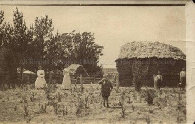
Photograph (Item), "Ellis Family Members Near Haystack At ""The Falls""", Malmsbury
People - "Ellis, Min (Nelson); Ellis, Em Jack Max And Hal" Buildings - "House, Haystack" Associated with - "Farm ""The Falls"" Malmsbury" -
 Malmsbury Historical Society
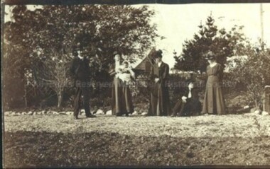
Photograph (Item), "Ellis, Vance And Townsend Family", Malmsbury c1900
... Buildings - House Associated with - "Farm ""The Falls"" Malmsbury"... Buildings - House Associated with - "Farm ""The Falls"" Malmsbury ...People - Ellis; Vance And Townsend Family Members Buildings - House Associated with - "Farm ""The Falls"" Malmsbury" -
 Malmsbury Historical Society
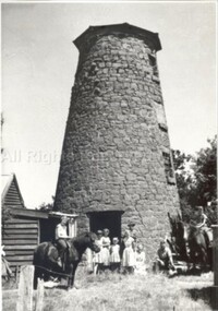
Photograph (Item), Old Stone Windmill At Windmill Farm Near Malmsbury, Malmsbury c1/1/1960
People - "Webster, J J" Buildings - Windmill Associated with - "Herald Sun, Herald Weekly Times" -
 National Wool Museum
Book, Belgenny Farm
... . History of the buildings of Belgenny Farm, part of the Camden Park..., 1988. History of the buildings of Belgenny Farm, part ..."Belgenny Farm" - Department of Planning, Sydney, 1988. History of the buildings of Belgenny Farm, part of the Camden Park Estate which was formerly owned by John and Elizabeth Macarthur.merino sheep - history sheep breeding - history sheep stations - history, macarthur, mr john macarthur, mrs elizabeth, belgenny farm, nsw, camden park estate, merino sheep - history, sheep breeding - history, sheep stations - history -
 Malmsbury Historical Society
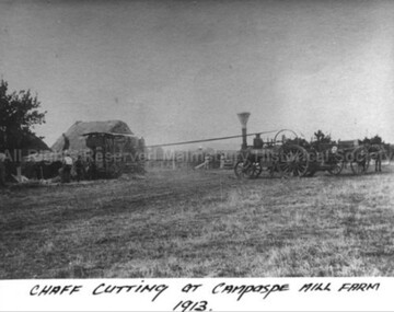
Photograph (Item), B/W Photo Of Chaff Cutting At Campaspe Mill Farm, Malmsbury 1913
Buildings - "Hay Stack, Chaff Cutter" People - "Ward, Betty (Mrs.)" -
 Malmsbury Historical Society
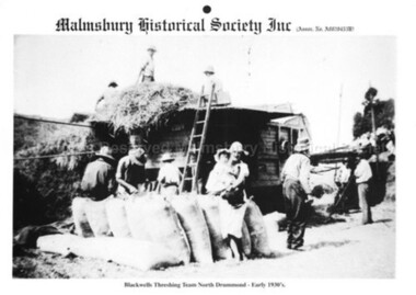
Photograph (Item), B/W Photo Of Threshing Team Blackwells Farm C1930, Malmsbury c1930
Associated with - Mhs Buildings - Threshing Machine People - Blackwell Family -
 Whitehorse Historical Society Inc.
Letter - Correspondence, Arlington, Blackburn Road, 26/04/1986 12:00:00 AM
Letter describing use of land 'Arlington',Letter describing use of land 'Arlington', Canterbury Road, Blackburn. Purchased in [1936] as a poultry farm and subdivided in 1947 into 7 shops and 5 building blocks.Letter describing use of land 'Arlington',pooley, beatrice, fred, arlington, canterbury road, blackburn south, land subdivision -
Whitehorse Historical Society Inc.
Article, Council moves on reserve, 2014
Plans for Healesville Freeway Reserve were changed by the Whitehorse Council.Plans for healesville Freeway Reserve were changed by the Whitehorse Council. The concept differs from the VicRoads draft , as a low-rise apartment building was removed.Plans for Healesville Freeway Reserve were changed by the Whitehorse Council. healesville freeway reserve, vicroads, nunawading community gardens, munroe, andrew, bennett, bill, carr, raylene, angus, neil, nadrasca farm, leane, shaun, barber, greg -
 Whitehorse Historical Society Inc.
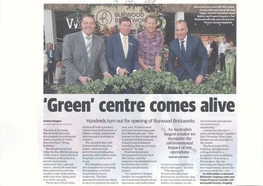
Article, 'Green' Centre Comes Alive, 09/12/2019
Burwood Brickworks has been officially opened as a living building.Burwood Brickworks has been officially opened as a living building with a 2000 sq. m. rooftop farm and 250 trees to cover the northern side of the centre & fruit trees lining each row of the car park.Burwood Brickworks has been officially opened as a living building. brickworks, shopping centre, environment, trees -
 Whitehorse Historical Society Inc.
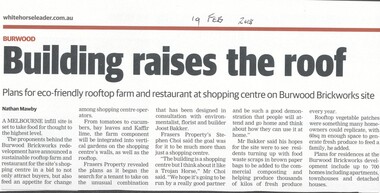
Article, Building Raises The Roof, 2018
The proponents of the Burwood Brickworks redevelopment have announced a sustainable rooftop farm and restaurant for the site's shopping centre.brickworks, burwood highway, burwood east, middleborough road, eley road, restaurants -
 Parks Victoria - Days Mill and Farm
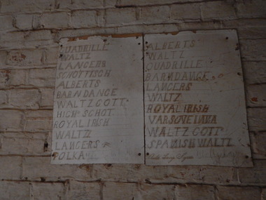
Document - Dance list
Local dances were held in the Mill buildings. This is one of two lists that survive from that time inside the mill. Handmade on property.Two pieces of cardboard nailed to the south wall. The sign contains a handwritten list of various dances. (see inscriptions for details)"QUADRILLE ALBERTS / WALTZ WALTZ / LANCERS QUADRILLE / SCHOTTISCH BARNDANCE / ALBERTS LANCERS / BARN DANCE WALTZ / WALTZ COTTN ROYAL IRISH / HIGH SCHOT VARSOVEINNA / ROYAL IRISH SPANISH WALTZ / LANCERS [copper plate] AULD LANG SYNE / POLKA"dancing, social gatherings -
 Parks Victoria - Days Mill and Farm
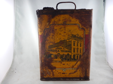
Container - Can
Found in an above ground rubbish pile at Days Mill and farm. The can was used to contain oil and probably used on site.Tall can with squared sides and wire handle at the top and a hole for pouring with intact cork. Yellow and red graphics with an image of a Victorian style building with early cars out the front. "RAMSAY & TREGANOWAN" and "XL OILS" written on the building yeswilliam day, ann day, joseph day, robert day -
 Ballarat Heritage Services
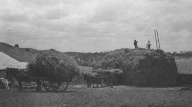
Photograph - Photograph - Black and White, Gervasoni Hay Stack at Yandoit Creek
Members of the Gervasoni Family building a haystack at their Yandoit Creek farm.gervasoni, yandoit creek, hay, hay stack, farm, farmers, agriculture -
 City of Ballarat Libraries
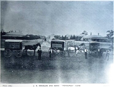
Postcard - Card Box Photographs, J.S. Douglas and Sons 'Roxburgh' Farm
... & 161 Chuck Photo Series. J.S. Douglas Roxburgh Farm Farming ...View from the Yard. Champion Jersey Bull 'Hero'. Ayrshire Stud. Milking Time. Plates 154, 155, 159, 160 & 161 Chuck Photo Series.j.s. douglas, roxburgh farm, farming, building, persons, costume, livestock -
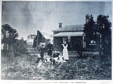 City of Ballarat Libraries
Postcard - Card Box Photographs, J. White's Ashford Vale Farm, Cardigan: The Homestead
Plate 177 Chuck Photo Series.j. white, ashford vale, farming, building, private dwelling, persons, costume -
 Whitehorse Historical Society Inc.
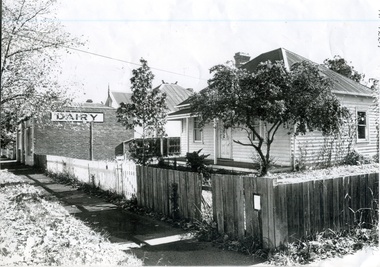
Photograph, Watts' Blackburn Dairy, c1929
The Watts family bought the dairy at 20 Albert St. in 1929 and increased the business from one to seven carts. From Albert St. they moved to Rialway Parade. In the beginning their milk came from a family dairy farm located in Moorabbin but after the Government required all milk to be pasteurised they obtained their milk from Crumps' dairy in Surrey Hills as was more efficientBlack and white photograph of the house and dairy belonging to the Watts family. House painted white and the dairy on the side of the brick building.dairies, watts' blackburn dairy, railway parade blackburn, watts don -
 Hume City Civic Collection
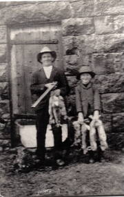
Photograph, Aitkens Gap Police Barracks, c1922
Frank Millett and his nephew Hopper Cahill are the two people standing by the building after spending the day shooting rabbits in 1922. They are standing in front of the Aitkens Gap Police Barracks. In the 1860s the gaol and stables were sold to George Millett and added to the Millett property. The Barracks and the new farm homestead were built by Mick Morrison. The Bald Hill Hotel at Aitkens Gap on the Bendigo Road (Calder Highway) was guilt by George Millett in 1854 and functioned until the gold began to run out after the Victorian Gold Rush of the 1850s. The Millett family continued to farm until 1967. The family also and operated hotels in the local area. A black and white photograph backed onto a white board of a man and a child holding some dead rabbits and standing in front of the doorway of a bluestone building. frank millett, george millett, aitkens gap gaol, hopper cahill -
 Ballarat and District Irish Association
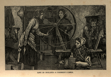
Image, Life in Ireland - A Farmer's Cabin, c1864
The tenant lived at the mercy of the resident landlord. Home was a one-roomed house, a chimney of wicker work plastered over with mud or just a hole in the roof. The walls might consist of mud too, or sods of grass. Any windows, were rarely glazed and would be open to the elements all year round. The Pig, if any, was kept in the house, the most valuable possession. Sold for cash at local market. The main items in the house were a potato pot and water bucket. As well as mother, father and children, there could well be grandparents all living in the same cramped conditions. The family would sleep on rushes or straw lain on the floor. Most tenants were tenants 'at will ', which meant they could be evicted at the 'will' of the landlord. Some had a lease for the life of the father and the eldest son, and this meant they were relatively safe from eviction as long as they could pay their rent. There was a tradition of passing on a portion of your land from father to each of the sons, who would build a small dwelling, and in turn pass a portion onto their own sons. This cycle of subdivision meant that many families were surviving on a tiny plot of land from which to derive a crop of potatoes for the year. Women worked hard in this environment, rearing children, cooking, cleaning, tending to any animals such a pigs or chicken and when needed, helping in the potato field. Life was dictated by the annual rent due to the landlord. Other typical expenses could be the Hearth Tax (actually charged by the number of fire places in a house) Turf, Hay (for any farm animals) and tithes. A tax known as the tithes were calculated at one tenth the value of everything saleable. Tithes were a bitter issue. They were for the support of the Church of Ireland, Protestant Bishops and Ministers, and a cess tax for the construction and maintenance of Protestant Church buildings. The problem being that the vast majority of those paying the Tax were Catholic and paying to support something that was contrary to their beliefs. Potatoes were the staple diet from September through to the end of Spring of the following year. But the summer months were months of hunger and hardship as they waited for the following harvest to come in Autumn. During these months people had to resort to eating anything they could find; turnips, cabbage, even wild grass, nettles, wild berries and dandelions. Those who lived close to the sea would collect seaweed and use it spread on their land as a form of manure. The dependency of so much of the population on the Potato as their sole source of food was to prove disastrous during the Famine years. [http://www.youririshroots.com/irishhistory/tenant.php, accessed 14 December 2013]A woman spins wools, while another cards fleece in preparation for spinning. I man smokes a pipe by an open fireplace, while a cow takes shelter in the cabin for warmth. ballarat irish, cabin, spinning, wool, cow -
Numurkah & District Historical Society
Ammunition Belt
Found inold shed on the farm we purchased. Could be Melville'sLeather ammunition belt -
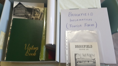 Numurkah & District Historical Society
Brookfield Tourist Farm: photos, visitor's book
Brookfield Homestead became a tourist farm in the 1970's Photo Album, pictures, visitor's book from Brookfield Tourist Farm brookfield homestead, tourism, farm, visitors, photos, -
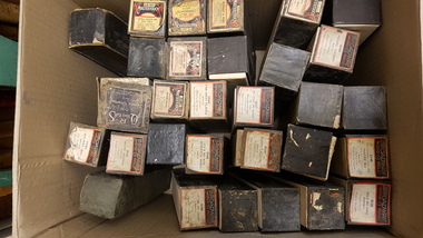 Numurkah & District Historical Society
Pianola Rolls
Pianola rolls belonged to Beverley Moss's paternal grandmother (Emily Moss, nee Tomlinson). Born approx. 1890 of Tallygaroopna, formerly of Katamatite. Farm selected at McKenzie Rd, by Henry Amos Moss70 x pianola rolls in original boxes Most have readable labels. Some damaged boxes pianola, piano, music, family entertainment -
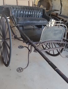 Numurkah & District Historical Society
Ladies Jinker
LADIES PONY GIG – circa early 1900’s) The gig was built by T Rose, North Melbourne. Australian coachbuilders adopted American designs and modified these to suit local conditions, eg mudguards added for muddy country roads. As roads improved, lighter and faster designs were made. These gigs were more comfortable than the normal farm cart / town cart (see nearby butcher’s cart), as they were often sprung for comfort rather than carrying heavy weights. (Donated by: Ivan & Gwen Russell, who purchased it from the Hogan Family, Tatura, in 1998) Ivan & Gwen Russell purchased this jinker from the Hogan Family at Tatura in 1998 "The only information we have is that it was built by T. Rose, North Melbourne. As it is in the original Condition we would like to donate it to the Numurkah Historical society to be displayed for others to enjoy. Black-painted ladies jinker (pony gig), with rubber tyred wheels, light hickory shafts, patterned black upholstery on seatT Rose Buildergig, jinker, horse-drawn vehicle, russell -
 Mt Dandenong & District Historical Society Inc.
Photograph, View Up Valley At Kalorama
John Lundy-Clarke grew up in the Kalorama/Mt Dandenong area and later in life (1972-74) began to write a comprehensive history of the area working from an original settlement map in an effort to cover all areas. The building in the centre of the photograph is 'Kia-Ora' guest house. Situated on Barber’s Road, ‘Kia-Ora’ was built in 1912 by George Barber. It was later leased by a Mrs Pemberthy. “Kia-Ora’ was one of four places connected when the telephone was brought into the district in 1912. The other places were ‘Mountjoy’, ‘Cherry Farm’ and ‘Callum House’. ‘Kia-Ora’ was burnt down in 1924. Black and White copy of section of a Rose Series postcard. Shows view up the valley at Kalorama with a decorative building centre middle of photograph. Handwritten description by John Lundy-Clarke on reverse.View up valley at Kalorama from near junction of Barbers and Doughty’s Rds. “Kia Ora” guest house in centre. Paynter’s “Iona” top left with “Kalorama” to its right. About 1912. Rose Series copied by JLC 1973.kalorama, kalorama valley, john lundy-clarke, barbers road, george barber, kia-ora, guest house, iona -
 Mt Dandenong & District Historical Society Inc.
Photograph, Walker's LOT 2
Harry Walker's property would have been run by his son William in 1922. When the CRB Road cut through the property William planted plum trees on the opposite side. These are visible in this photo. An extensive raspberry crop is in the foreground. The building over the road on the left hand side is the corn and produce store built by Edward John Price (son of Edward Joseph Price) to capitalise on the CRB Road cutting through the Price farm. John Lundy-Clarke grew up in the Kalorama/Mt Dandenong area and later in life (1972-74) began to write a comprehensive history of the area working from an original settlement map in an effort to cover all areas.Small black and white postcard showing a crop in foreground with a house to the right. A road passes through the centre with a house on the left on the opposite side of the road. A view to the ranges in the distance. A handwritten description on reverse by John Lundy-Clarke.View at Kalorama. View over LOT 2 (Walkers) 1922.harry walker, william walker, crb road, raspberry, edward john price, edward joseph price, produce store, store -
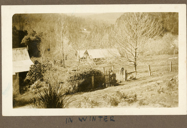
 Mt Dandenong & District Historical Society Inc.
Photograph, Erith Lane
Erith Lane would have been named after Eliza Erith, the wife of Thomas Hand of Mountain Grange. The house made of slabs and bark pictured (centre) is where the family lived before Mountain Grange was built. Mabel Hand, Thomas and Eliza's youngest daughter stated that she was born in the bark hut in 1881 and they moved into the new home the same year. Cherry Farm, the roof visible behind the centre building, was the home of William Hand, son of Thomas and Eliza. He lived here with hs wife, Harriet Toghill, before moving to live at Mountain Grange after 1905.Black and white photograph showing a scene under heavy snow. Two cottages and a rooftop visible. Snow laden vines forming the front fence. Taller trees visible in the background. Reverse of photograph has handwritten description by John Lundy-Clarke.Erith Lane under snow. House in passion fruit Ivory’s holiday home 1921. Building in centre was Hand’s 28’ by 22’ house of slabs and bark. The first house on top of the whole Dandenong Range built 1871. Large roof behind it was “Cherry Farm”.eliza erith, eliza hand, mabel hand, thomas hand, william hand, erith lane, kalorama, snow, mountain grange, cherry farm, harriet toghill -
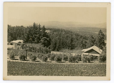
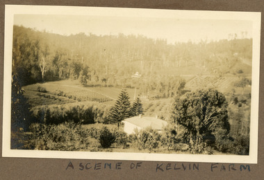 Mt Dandenong & District Historical Society Inc.
Photograph
Most likely a scene of 'Mt Calvin', the homestead built by John William (Willie) Richardson for his wife Jeanie Green of Wandin. The house was built c1898 The Rowse family purchased the house and 60 acres when Willie and Jeanie Richardson with their 3 children moved to Brisbane. The Rowse family farmed the 60 acres for 35 years and the house was demolished in 1938. The photograph is from the album of Ivy May Child. Ivy May Child (1910 – 1989) was the daughter of Arthur Edward (Ted) Child (1878 – 1964) and Ethel May Madden (1888 – 1970). Ted Child was the son of Matthew Francis Child (1839 – 1933) and Martha Jeeves (1857 – 1926). He was the grandson of one of the early pioneers Francis Child. Ivy grew up on the family property on Childs Road and took many photographs. Most of these are glued into her photo album. The album covered the years from c1927 – 1932. Ivy married Henry William Burgess (1906 – 1968) in 1944. The photographs remain in their original state in the album with individual copies made. Black and white photograph with a house in the foreground looking over cultivated fields with treed hills in the background. A building is visible in the centre in the distance.Written below the photograph in the album" A SCENE OF KELVIN FARMmt calvin, kelvin farm, calvin farm, richardson, rowse, jeanie richardson, john william richardson, willie richardson -
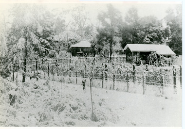
 Mt Dandenong & District Historical Society Inc.
Photograph
The photograph is from the album of Ivy Child. The buildings form part of the Child family farm where Ivy Child lived with her parents Ted and Ethel Child. The photograph is taken in winter with the trees devoid of leaves. Ivy May Child (1910 – 1989) was the daughter of Arthur Edward (Ted) Child (1878 – 1964) and Ethel May Madden (1888 – 1970). Ted Child was the son of Matthew Francis Child (1839 – 1933) and Martha Jeeves (1857 – 1926). He was the grandson of one of the early pioneers Francis Child. Ivy grew up on the family property on Childs Road and took many photographs. Most of these are glued into her photo album. The album covered the years from c1927 – 1932. Ivy married Henry William Burgess (1906 – 1968) in 1944. The photographs remain in their original state in the album with individual copies made. Sepia photograph showing a group of buildings - a homestead and sheds. There is a wire fence and gate at the front. A woman wearing a hat is about to go through the gate. She is carrying a suitcase. Trees and bushes surround the property and a cleared area and rooftop are visible in the distance.Handwritten below the photograph in album: IN SUMMERivy child, child, winter, ted child, ethel child -
 Mt Dandenong & District Historical Society Inc.
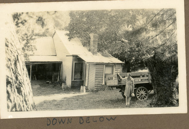
Photograph
Photograph is from the album of Ivy Child. The back view of the homestead is either the Kalorama homestead of Ivy's parents, Ted and Ethel Child or her grandfather, Matthew Francis Child. Ivy May Child (1910 – 1989) was the daughter of Arthur Edward (Ted) Child (1878 – 1964) and Ethel May Madden (1888 – 1970). Ted Child was the son of Matthew Francis Child (1839 – 1933) and Martha Jeeves (1857 – 1926). He was the grandson of one of the early pioneers Francis Child. Ivy grew up on the family property on Childs Road and took many photographs. Most of these are glued into her photo album. The album covered the years from c1927 – 1932. Ivy married Henry William Burgess (1906 – 1968) in 1944. The photographs remain in their original state in the album with individual copies made. Black and white close up photograph of the rear of a wooden building. A girl holding a sun hat is standing with her arm on the tray of an old truck.Handwritten below the photograph in album: DOWN BELOWivy child, kalorama, homestead, farm, matthew francis child, child, ted child -
 Mt Dandenong & District Historical Society Inc.
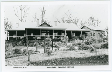
Photograph, Braco Park, c1913
Braco Park Guest House was owned by the aunts of Sir Keith Murdoch, Eliza and Grace. It became a Red Cross convalescent Home for nurses in 1918.It was sold to Mrs. Techow and renamed "Clovelly" in 1920. It had been the Murdoch sisters' guest house, Braco Park, that originally introduced Prime Minister Billy Hughes to the hills. Walter Murdoch's nephew Keith Murdoch, a young parliamentary reporter for the Age, took Hughes and several other politicians up there before the war. Keith's father had been a friend of the previous PM, Andrew Fisher. Keith Murdoch was sent to London as a reporter in 1915, and developed an influential relationship with Hughes who bought a small farm in Sassafras, and ran some of the business of government there during the war and after. Acquired by The Education Department about 1985, the Sherbrooke Community School was built, with the Clovelly house being stripped back to its frame and renovated to form the main building of the school. An existing cottage on the site is also used. B & W postcard showing the front view of Braco Park with another small building to the RHS. Newly planted garden in the front.The Rose Series P. 106. "BRACO PARK" SASSAFRAS, VICTORIA.braco park, clovelly, guest house, murdoch, sherbrooke community school -
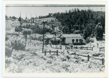
 Department of Health and Human Services
Photograph, Ararat Mental Hospital - Early landscape & farm land surrounding the main buildings of Ararat Mental Hospital "Aradale" - Black & White Photo