Showing 11205 items matching " historical series"
-
 Eltham District Historical Society Inc
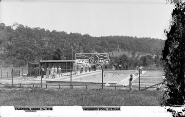
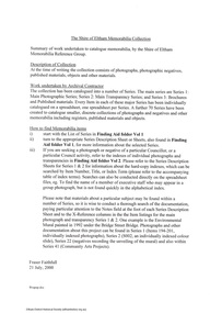
Negative - Photograph, The Rose Stereograph Company, Swimming Pool, Eltham, c.1939
Eltham swimming pool was opened in December 1936. It was located adjacent to Central Park. The small children's pool in the foreground was opened in November 1938. This glass plate negative was used to manufacture postcards (1:1 printing) for commercial sale by the Rose Sterograph Company and its subsidiaries. George Rose founded the Rose Stereograph Company in 1880 and was joined by Herbert (Bert) Cutts in the early 20th Century. The pair formed a lifetime working partnership and strong personal friendship. Assisted by George’s two sons, Herbert George and Walter, and later by Neil Cutts, the Rose Stereograph Company continued its operations for more than 140 years. The company was initially built on stereographs, but as cinema took over and stereographs fell out of fashion, the Rose Stereograph Company developed Australia’s first commercially viable photographic postcard business. Specialising in postcards of iconic historical moments and significant landmarks, The Rose Stereograph Company became a staple of the Australian travel industry.This remarkable collection of glass plate negatives, transparencies, and postcards – arguably Australia’s most significant photography collection outside of public hands – has been passed down through the generations, surviving war, relocation, and the harsh Victorian climate. The historic Rose Stereograph collection is the culmination of George Rose’s dream of capturing and preserving precious moments in time and remains the legacy of the Rose and Cutts families. It is with great sadness that the Cutts family says goodbye to a collection that spans five generations and 140 years. The Cutts family understands that for these historically important pieces to rest with one family is to deny others the pleasure of their custodianship.Glass Plate Negative Size: 9 x 13.9 cmSwimming Pool, Eltham, Valentine Series No. 3198, Copyrighteltham, postcard, travel, rose stereograph company, valentine series postcard, glass plate negative, central park, eltham central park, swimming pool, peter and elizabeth pidgeon collection -
 Eltham District Historical Society Inc
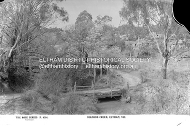
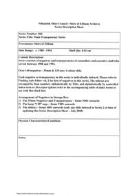
Negative - Photograph, The Rose Stereograph Company, Diamond Creek, Eltham, Vic, c.1919
Shows two bridge crossings over the Diamond Creek in Diamond Street, Eltham. The upper pedestrian crossing provided continual access for foot traffic during times of flood. The railway came to Eltham in 1901, the Eltham Railway Station is visible in the distance as well as a wooden bodied Tait (Red Rattler) First Class train carriage. The Tait train was first introduced in 1910 as a steam locomotive hauled carriage and in 1919 electric motor carriages were introduced however the line to Heidelberg was not electrified till 1921 and to Eltham in April 1923. The Railway General Store on Main Road is visible beyond the station and was built by Luther Haley in 1902. It was the first shop in the present day shopping centre. It was later known as lloyd's stopre (1917-1920) followed by a succession of six other owners until purchased by Eric Staff in 1939. This glass plate negative was used to manufacture postcards (1:1 printing) for commercial sale by the Rose Sterograph Company and its subsidiaries. George Rose founded the Rose Stereograph Company in 1880 and was joined by Herbert (Bert) Cutts in the early 20th Century. The pair formed a lifetime working partnership and strong personal friendship. Assisted by George’s two sons, Herbert George and Walter, and later by Neil Cutts, the Rose Stereograph Company continued its operations for more than 140 years. The company was initially built on stereographs, but as cinema took over and stereographs fell out of fashion, the Rose Stereograph Company developed Australia’s first commercially viable photographic postcard business. Specialising in postcards of iconic historical moments and significant landmarks, The Rose Stereograph Company became a staple of the Australian travel industry.This remarkable collection of glass plate negatives, transparencies, and postcards – arguably Australia’s most significant photography collection outside of public hands – has been passed down through the generations, surviving war, relocation, and the harsh Victorian climate. The historic Rose Stereograph collection is the culmination of George Rose’s dream of capturing and preserving precious moments in time and remains the legacy of the Rose and Cutts families. It is with great sadness that the Cutts family says goodbye to a collection that spans five generations and 140 years. The Cutts family understands that for these historically important pieces to rest with one family is to deny others the pleasure of their custodianship.Glass Plate Negative Size: 9 x 13.9 cmDiamond Creek, Eltham, Vic., The Rose Series P. 4314, Copyrighteltham, postcard, travel, rose stereograph company, glass plate negative, rose series postcard, tait train, eltham railway station, railway store, staffs general store, diamond creek, diamond street bridge, lloyd's general store, railway station, peter and elizabeth pidgeon collection -
 Eltham District Historical Society Inc
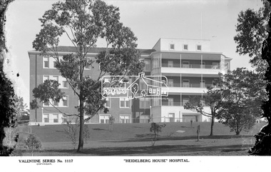
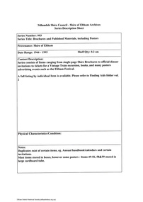
Photograph, The Rose Stereograph Company, "Heidelberg House" Hospital, c.1938
View looking across a treed landscape lawn towards the new 'Heidelberg House' at the Austin Hospital, which was opened in 1939. This glass plate negative was used to manufacture postcards (1:1 printing) for commercial sale by the Rose Sterograph Company and its subsidiaries. George Rose founded the Rose Stereograph Company in 1880 and was joined by Herbert (Bert) Cutts in the early 20th Century. The pair formed a lifetime working partnership and strong personal friendship. Assisted by George’s two sons, Herbert George and Walter, and later by Neil Cutts, the Rose Stereograph Company continued its operations for more than 140 years. The company was initially built on stereographs, but as cinema took over and stereographs fell out of fashion, the Rose Stereograph Company developed Australia’s first commercially viable photographic postcard business. Specialising in postcards of iconic historical moments and significant landmarks, The Rose Stereograph Company became a staple of the Australian travel industry.This remarkable collection of glass plate negatives, transparencies, and postcards – arguably Australia’s most significant photography collection outside of public hands – has been passed down through the generations, surviving war, relocation, and the harsh Victorian climate. The historic Rose Stereograph collection is the culmination of George Rose’s dream of capturing and preserving precious moments in time and remains the legacy of the Rose and Cutts families. It is with great sadness that the Cutts family says goodbye to a collection that spans five generations and 140 years. The Cutts family understands that for these historically important pieces to rest with one family is to deny others the pleasure of their custodianship.Glass Plate Negative Size: 9 x 14 cm"Heidelberg House" Hospital, Velentine Series No. 1117, Copyrightpostcard, travel, rose stereograph company, glass plate negative, ray trinham, austin hospital, heidelberg house, valentine series postcard, heidelberg, peter and elizabeth pidgeon collection -
 Eltham District Historical Society Inc
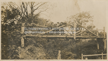
Photograph, "Curry, Byrne, McGeachy & self on rustic bridge, Eltham", 22 Oct 1919
The old Diamond Street bridge in Eltham had a raised section seen here and a lower section, the railings of which can just be seen. The upper pedestrian crossing provided continual access for foot traffic during times of flood. This photo is part of the Alice Broadhurst collection held by Yarra Plenty Regional Library, a series of 12 photo albums compiled by Alice Broadhurst (1896-1981), initially while working as a Voluntary Aid Detachment nurse with the Australian Red Cross at the Mont Park Military Hospital (No. 16 AGH) and subsequently as a nurse at the Royal Melbourne and Royal Women’s hospitals alongside many pioneering doctors of their fields. This photo depicts an outing with fellow VAD nurses McGeachy and Byrne and two patients of Mont Park, Curry and Caffery to Eltham in spring 1919 Digital file"Curry, Byrne, McGeachy & self on rustic bridge, Eltham, Oct 22, 1919"eltham, diamond creek, diamond street bridge, alice elizabeth broadhurst, byrne, caffery, curry, mcgeachy, nursing staff, mont park, 16 agh -
 Eltham District Historical Society Inc
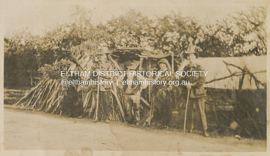
Photograph, "McGeachy, Curry, Byrne & Caffery with an old man who lives there at Eltham", 22 Oct 1919
This photo depicts an outing of VAD nurses Alice Broadhurst, McGeachy and Byrne and two patients of No. 16 AGH Macleod (Mont Park Military Hospital), Curry and Caffery to Eltham in spring 1919. Broadhurst's companions pose with an old timer from Eltham on the roadside verge with a large collection of sticks stacked vertically outside a cottage. This photo is part of the Alice Broadhurst collection held by Yarra Plenty Regional Library, a series of 12 photo albums compiled by Alice Broadhurst (1896-1981), initially while working as a Voluntary Aid Detachment nurse with the Australian Red Cross at the Mont Park Military Hospital (No. 16 AGH) and subsequently as a nurse at the Royal Melbourne and Royal Women’s hospitals alongside many pioneering doctors of their fields.Digital file"McGeachy, Curry, Byrne & Caffery with an old man who lives there at Eltham"eltham, alice elizabeth broadhurst, byrne, caffery, curry, mcgeachy, nursing staff, mont park, 16 agh, old timer, pioneer, cottage, wood pile -
 Eltham District Historical Society Inc
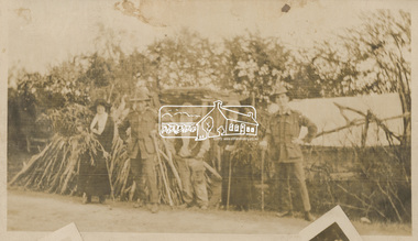
Photograph, "Same group with self instead of Byrne, Eltham", 22 Oct 1919
This photo depicts an outing of VAD nurses Alice Broadhurst, McGeachy and Byrne and two patients of No. 16 AGH Macleod (Mont Park Military Hospital), Curry and Caffery to Eltham in spring 1919. Broadhurst's companions pose with an old timer from Eltham on the roadside verge with a large collection of sticks stacked vertically outside a cottage. This photo is part of the Alice Broadhurst collection held by Yarra Plenty Regional Library, a series of 12 photo albums compiled by Alice Broadhurst (1896-1981), initially while working as a Voluntary Aid Detachment nurse with the Australian Red Cross at the Mont Park Military Hospital (No. 16 AGH) and subsequently as a nurse at the Royal Melbourne and Royal Women’s hospitals alongside many pioneering doctors of their fields.Digital file"Same group with self instead of Byrne, Eltham, Oct 22"eltham, alice elizabeth broadhurst, byrne, caffery, curry, mcgeachy, nursing staff, mont park, 16 agh, old timer, pioneer, cottage, wood pile -
 Eltham District Historical Society Inc
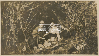
Photograph, Picnic at Eltham with Caffery, Curry, Byrne and McGeachy, 22 Oct 1919
This photo depicts an outing of VAD nurses Alice Broadhurst, McGeachy and Byrne and two patients of No. 16 AGH Macleod (Mont Park Military Hospital), Curry and Caffery to Eltham in spring 1919. Broadhurst's companions pose sitting on a creek bank around a open suitcase which containes their picnic spread. This photo is part of the Alice Broadhurst collection held by Yarra Plenty Regional Library, a series of 12 photo albums compiled by Alice Broadhurst (1896-1981), initially while working as a Voluntary Aid Detachment nurse with the Australian Red Cross at the Mont Park Military Hospital (No. 16 AGH) and subsequently as a nurse at the Royal Melbourne and Royal Women’s hospitals alongside many pioneering doctors of their fields.Digital fileeltham, alice elizabeth broadhurst, byrne, caffery, curry, mcgeachy, nursing staff, mont park, 16 agh, diamond creek, picnic -
 Eltham District Historical Society Inc
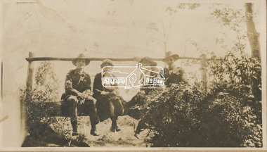
Photograph, "Resting, Eltham", 22 Oct 1919
This photo depicts an outing of VAD nurses Alice Broadhurst, McGeachy and Byrne and two patients of No. 16 AGH Macleod (Mont Park Military Hospital), Curry and Caffery to Eltham in spring 1919. Broadhurst's companions pose sitting on a log bridge. This photo is part of the Alice Broadhurst collection held by Yarra Plenty Regional Library, a series of 12 photo albums compiled by Alice Broadhurst (1896-1981), initially while working as a Voluntary Aid Detachment nurse with the Australian Red Cross at the Mont Park Military Hospital (No. 16 AGH) and subsequently as a nurse at the Royal Melbourne and Royal Women’s hospitals alongside many pioneering doctors of their fields.Digital fileeltham, alice elizabeth broadhurst, byrne, caffery, curry, mcgeachy, nursing staff, mont park, 16 agh, log bridge -
 Eltham District Historical Society Inc
Document - Series Listing, Fraser Faithfull et al, The Shire of Eltham Memorabilia Collection, 2000
The collection has been catalogued into a number of Series. The main series are Series 1: Main Photographic Series; Series 2: Main Transparency Series; and Series 3: Brochures and Published materials. Every Item in each of these major Series has been individually catalogued on a spreadsheet, one spreadsheet per Series. A further 70 Series have been created to catalogue smaller, discrete collections of photographs and negatives and other memorabilia including registers, published materials and objects. The completion of its transfer to the Society was noted in Newsletter No. 159 November 2004. Generally memorabilia items classified as part of Council 's art collection and negatives of historical photographs have been retained by the Council. The items now stored at our Local History Centre are quite diverse. They include many photographs of Council activities, Councillors and Council staff. There are Council brochures, calendars and other publications. All of these items are catalogued and stored in quality archival boxes. Also included is a large collection of old Council registers such as letter books, contract registers, cash books, etc. Many of these are large leather bound volumes, more of interest for their appearance than for their content. The first meeting of the Memorabilia Reference Group was held December 5, 1996. The aim of the group was to facilitate all actions required for the safekeeping of the Shire of Eltham memorabilia. The members of the group were Harry Gilham President of the Eltham District Historical Society (EDHS), Russell Yeoman EDHS Secretary and Chris Marks Curator of Collections at NSC.shire of eltham archives, series listing, memorabilia reference group -
 Eltham District Historical Society Inc
Document - Series Listing, Fraser Faithfull et al, Series 02: Main Transparency Series, 2000
Series consists of negatives and transparencies of councillors and executive staff who served between 1988 and 1994. Over 140 negatives - 35mm & 120 size; l colour slide.shire of eltham archives, series listing -
 Eltham District Historical Society Inc
Document - Series Listing, Fraser Faithfull et al, Series 03: Brochures and Published Materials, including Posters, 2000
Series consists of Items ranging from single-page Shire Brochures to official dinner invitations to tickets for a Vintage Train excursion, books, and many posters advertising events such as the Eltham Festival.shire of eltham archives, series listing -
 Eltham District Historical Society Inc
Document - Series Listing, Fraser Faithfull et al, Series 05: Council - Annual Framed Portraits of Individual Councillors, 2000
Series consists offramed settings of 9 individual portraits of each years' councillors. There are 8 items in total: I) 1987/88 2) 1988/89 3) 1989/90 4) 1990/91 5) 1991/92 6) 1992/93 7) 1993/94 8) 1994shire of eltham archives, series listing -
 Eltham District Historical Society Inc
Document - Series Listing, Fraser Faithfull et al, Series 06: Council Meeting September 1993, Shire President Pamela Sladden, 16 B&W photographs, 2000
Series consists of 16 black and white photographs taken at a Council meeting chaired by Councillor Pamela Sladden, Shire President. The images depict Shire President Sladden seated in chambers, and with her family. This series also includes shots of Cr Jim Connor with his partner.shire of eltham archives, series listing -
 Eltham District Historical Society Inc
Document - Series Listing, Fraser Faithfull et al, Series 07: Council Meeting September 1993, Shire President Pamela Sladden, 17 B& W photographic negatives, 2000
Series consists of 17 black and white 35mm photographic negatives taken at a Council meeting chaired by Councillor Pamela Sladden, Shire President. The images depict Shire President Sladden seated in chambers, and with her family. This series also includes shots of Cr Jim Connor with his partner.shire of eltham archives, series listing -
 Eltham District Historical Society Inc
Document - Series Listing, Fraser Faithfull et al, Series 08: Youth Art Award Presentations, 50 colour photographs, 2000
Series consists of 50 colour photographs taken at Youth Art Award Presentations, with Cr John Graves officiating. Photographs include shots of winners receiving certificates, artworks on display, members of the Y AA committee, a selection of prize-winning entries.shire of eltham archives, series listing -
 Eltham District Historical Society Inc
Document - Series Listing, Fraser Faithfull et al, Series 09: Youth Art Award Exhibits, 50 colour negatives, 2000
Series consists of 50 colour negatives depicting art works on display at a Youth Art Award.shire of eltham archives, series listing -
 Eltham District Historical Society Inc
Document - Series Listing, Fraser Faithfull et al, Series 10: Shire President Mary Grant receiving Chain, with her family at Council Meeting, black and white negatives, 2000
Series consists of one page of 39 black and white negatives, most of which were taken on the night of Cr Mary Grant's receiving the Shire President's chain. Includes 13 shots ofa council meeting and a number of shots of Cr Grant with her family, including her partner Doug Owens. A second page of 17 black and white negatives (of Shire Scenes and Council Stall) includes a number of shots of Cr Mary Grant and her family.shire of eltham archives, series listing -
 Eltham District Historical Society Inc
Document - Series Listing, Fraser Faithfull et al, Series 11: Eltham Festivals, photographic negatives and slides, 2000
Series consists of 1285 black & white and colour negatives and 44 colour slides depicting activities at annual Eltham Festivals. The series consists of the following: Eltham Festival 1988: 37 B&W negatives Eltham Festival 1989: 25 B&W negatives, 243 colour Eltham Festival 1990: 202 colour negatives Eltham Festival 1991: 115 colour negatives Eltham Festival 1992: 20 B&W negatives Eltham Festival 1993: 44 Colour slides, 36 B&W negatives, 52 colour negatives Eltham Festival, undated, 555 colour negativesshire of eltham archives, series listing -
 Eltham District Historical Society Inc
Document - Series Listing, Fraser Faithfull et al, Series 12: Councillors' Social Functions, 231 colour negatives, 2000
Series consists of 231 colour negatives documenting three Councillor social functions : Past Councillors Dinner 1990; End of Council Year Dinner 1990; Shire President's Dinner Dance (June?) 1991.shire of eltham archives, series listing -
 Eltham District Historical Society Inc
Document - Series Listing, Fraser Faithfull et al, Series 13: Eltham Shire Photograph Album 1985, 2000
Series consists of 174 colour and B&W photographs of sites and activities in the Shire of Eltham. Most shots are 150mm by 100, though there are a number of smaller shots laid out in montages, and 6 large (A4 size) colour shots. Subjects documented include the Eltham Library, Eltham Lower Park, Eltham Senior Citizens Centre, Housing Development, the Council Depot, Shire Offices, Eltham Child Care Centre, Miniature Railway, Community Centre, the Bike Track, a Citizenship Ceremony, Shillingham Cottage, Eltham Town Park and other sites.shire of eltham archives, series listing -
 Eltham District Historical Society Inc
Document - Series Listing, Fraser Faithfull et al, Series 14: Eltham Leisure Centre Extensions 1990-1991, 41 colour photographs, 2000
Series consists of 41 colour photographs recording work on extensions to the Eltham Leisure Centre as well as a number of shots of the completed building and shots taken at a function at the newly reopened centre.shire of eltham archives, series listing -
 Eltham District Historical Society Inc
Document - Series Listing, Fraser Faithfull et al, Series 15: Eltham Leisure Centre Extensions 1990-1991, industrial dispute, photographs, 2000
Series consists of colour photographs as follows: I) Two copies each of53 colour photographs measuring 175 x 125mm 2) Twenty colour polaroids of the site taken between 29/5/91 and 13/6/91 The photographs document work done on the site at the corner of Susan St and Brougham St, Eltham.shire of eltham archives, series listing -
 Eltham District Historical Society Inc
Document - Series Listing, Fraser Faithfull et al, Series 16: Eltham Leisure Centre Extensions 1990-1991 , industrial dispute, photographic negatives, 2000
Series consists of 26 colour negatives recording activity on the building site, including a visit by police officers.shire of eltham archives, series listing -
 Eltham District Historical Society Inc
Document - Series Listing, Fraser Faithfull et al, Series 17: Murphy's House, Panton Hill, 18 colour photographs, 2000
Series consists of 18 colour photographs of the interior and exterior of Murphy's House, a property purchased by Eltham Shire for community use.shire of eltham archives, series listing -
 Eltham District Historical Society Inc
Document - Series Listing, Fraser Faithfull et al, Series 18: Murphy's House, Panton Hill, 20 colour negatives, 2000
Series consists of 20 colour negatives of the interior and exterior of Murphy's House, a property purchased by Eltham Shire for community use.shire of eltham archives, series listing -
 Eltham District Historical Society Inc
Document - Series Listing, Fraser Faithfull et al, Series 19: Eltham Shire Offices, Entertainment Area Refurbishment, 16 colour photographs, 2000
Series consists of 16 colour photographs of contractors at work inside the Shire Offices. Includes photographs of CEO Rodney Roscholler and Cr Mary Grant.shire of eltham archives, series listing -
 Eltham District Historical Society Inc
Document - Series Listing, Fraser Faithfull et al, Series 20: Eltham Library construction, 350 photographic negatives, 2000
Series consists of I) 9 B&W negatives of the library under construction, with Librarian Linda McConnell on site. 2) 24 colour negatives depicting the interior of the new library. 3) A set of approximately 320 colour negatives documenting month-by-month progress in construction of the library. These negatives are arranged chronologically. 4) A supplementary page contains a number of negatives of sketch plans of the new library.shire of eltham archives, series listing -
 Eltham District Historical Society Inc
Document - Series Listing, Fraser Faithfull et al, Series 21: Eltham Library construction, 300 photographs, sketch plans, 2000
Series consists of I) 7 sepia toned photographs or Librarian Linda McConnell inspecting work on the site orthe new library. 2) 11 B& W, sepia and colour photographs or work on the site. 3) 3 laminated colour sketches: floor plan, roor plan & exterior 4) A set or approximately 280 colour snapshots documenting work on the construction site, arranged chronologically month-by-month. There are also 5 "panorama" panels or between 2-4 snapshots taped together. These have been mounted on acid-free card.shire of eltham archives, series listing -
 Eltham District Historical Society Inc
Document - Series Listing, Fraser Faithfull et al, Series 22: Environmental Mural Unveiling, 20 February 1992, 20 colour negatives, 2000
Series consists of 20 colour negatives taken on the occasion of the unveiling of the environmental mural under the Bridge Street bridge on 20 February 1992. Includes shots of Shire President John Cohen snipping the ribbon and talking with artist Megan Evans.shire of eltham archives, series listing -
 Eltham District Historical Society Inc
Document - Series Listing, Fraser Faithfull et al, Series 23: Statutory Council Meeting, August 1991 , 42 B&W negatives, 2000
Series consists of 42 B&W negatives depicting the swearing-in of new Councillors and the new Shire President Cr John Cohen. Includes a number of portraits of Cr Cohen.shire of eltham archives, series listing