Showing 1534 items
matching aerial photographs
-
 Forests Commission Retired Personnel Association (FCRPA)
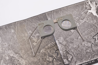
Pocket Stereoscope
... Small pocket stereoscope to interprete aerial photographs... and overlapping aerial photos as a single three-dimensional image ...This pocket stereoscope was used to view a pair of separate and overlapping aerial photos as a single three-dimensional image. It was small and could be easily used in the field. Larger, mirror stereoscope were also available in some offices. The aerial images were used to map forest types, timber stands, new roads and tracks, firebreaks, boundaries of timber harvesting, plantations, bushfires, insect and disease attack and so on In 1928, the Forests Commission undertook its first major aerial photography project over 15,000 acres of forest which is said to be the first of its kind in Australia. During the Second World War, large areas of Victoria were photographed by RAAF and used to produce orthophoto maps. By 1945 aerial photography of 13,000 square miles (3.4 M ha) was completed, including much of the inaccessible eastern forests. The Forests Commission started developing its own small format photography in the early 1970s. Simple, cheap and rapid methods of obtaining photographs using 70mm and 35mm cameras were developed Small pocket stereoscope to interprete aerial photographs in the field Adjustable lenses on foldaway wire legsSokkisha Tokyoforest measurement, surveying, forests commission victoria (fcv) -
 St Kilda Historical Society
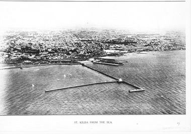
Photograph - Photograph Arial
... aerial photograph... Carlisle Street St Kilda melbourne aerial photograph St Kilda from ...aerial photographPhotograph black and white arial Copy of original. View of water, yachts in foreground and pier with Catani gardenes midground and rest of St kilda in distance.St Kilda from the Sea -
 Phillip Island and District Historical Society Inc.
Photograph
... Black & White Aerial Photograph showing the two bridges... Aerial Photograph showing the two bridges between Newhaven ...Photograph from The Herald and donated by Jack MorrisonBlack & White Aerial Photograph showing the two bridges between Newhaven and San Remo, the old and the new.local history, photography, photographs, slides, film, civil engineering, bridges, history of the phillip island bridge, black & white photograph, phillip island bridge -
Phillip Island and District Historical Society Inc.
Newspaper clippings, 23/05/1973
... Aerial photograph of Churchill Island and article... Aerial photograph of Churchill Island and article on history ...Article on prospective sale of Churchill & Elizabeth Islands. Short history of Islands and photographs of Churchill Island and Cairn to commemorate pioneer wheat growing 1801.Aerial photograph of Churchill Island and article on history of Churchill Island and Elizabeth Island and prospective sale of the Islands.local history, documents, newspapers, newspaper clipping, churchill island, elizabeth island, black & white newspaper clipping, churchill island, first wheat crop in australia, lt grant -
 Phillip Island and District Historical Society Inc.
Photograph, R.A.A.F, 1939
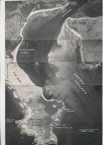
... aerial photograph...Aerial Photograph of eastern end of Phillip Island... Island local history photography aerial photograph eastern ...One of a collection of over 400 photographs in an album commenced in 1960 and presented to the Phillip Island & Westernport Historical Society by the Shire of Phillip IslandAerial Photograph of eastern end of Phillip Island and the Eastern Passage taken by the RAAF in 1939 at 13,000 feet.local history, photography, aerial photograph, eastern passage, cape woolamai, black & white photograph, coastline, r.a.a.f., john jenner, bryant west -
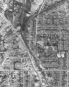
 Greensborough Historical Society
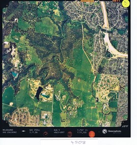
Aerial photograph, Qascophoto, Greensborough, 03/11/1986
... Aerial photograph...Colour aerial photograph QAS 2504c run 5 3/11/86 1:15,500... road Colour aerial photograph QAS 2504c run 5 3/11/86 1:15,500 ...Aerial survey of Plenty Gorge Park area, including Greensborough by-pass construction and Metropolitan Ring Road reservation.An historical view of developing GreensboroughColour aerial photograph QAS 2504c run 5 3/11/86 1:15,500 by Qascophotoplenty gorge park, greensborough bypass, metropolitan ring road -
Glenelg Shire Council Cultural Collection
Photograph - Photograph - Portland Smelter, c. 1980
... Framed aerial photograph of Portland Smelter taken... in offices at Smelter Portland Smelter Framed aerial photograph ...Previously displayed in offices at SmelterFramed aerial photograph of Portland Smelter taken in the 1980's. Image shows the town of Portland in the background.portland smelter -
Glenelg Shire Council Cultural Collection
Photograph - Photograph - Portland Smelter, c. 1980
... Framed aerial photograph of Portland smelter taken... in Offices at the Smelter. Portland Smelter Framed aerial photograph ...Previously displayed in Offices at the Smelter.Framed aerial photograph of Portland smelter taken in the 1980's. Image show's Lawrence Rocks in the background.portland smelter -
Glenelg Shire Council Cultural Collection
Photograph - Photograph -Reclamation and Canal work, 1959
... Black and white aerial photograph showing land reclamation..., pencil. Black and white aerial photograph showing land ...Port of Portland Authority ArchivesBack: November 1959 - Top right, black biro. Reclamation and canal work at southern end of botanic gardens - bottom left, pencil.port of portland archives, land reclamation, canal -
Glenelg Shire Council Cultural Collection
Photograph - Photograph - land reclamation, 1959
... Black and white aerial photograph showing land reclamation... November 1959 - typed. Black and white aerial photograph showing ...Port of Portland Authority ArchivesFront: Canal and Reclamation. Aerial view west November 1959 - typed.port of portland archives, land reclamation, canal, botanic gardens -
Glenelg Shire Council Cultural Collection
Photograph - Photograph - K. S. Anderson Wharf, n.d
... and surrounds. Aerial photograph taken from North East.... and surrounds. Aerial photograph taken from North East. Photograph ...Port of Portland Authorityport of portland archives, aerial photography, portland harbour -
Lakes Entrance Historical Society
Photograph, 14/04/2013 12:00:00 AM
... Aerial Photograph...Colour aerial photograph of Entrance at New Works showing... Entrance gippsland Aerial Photograph Waterways Topography New Works ...Colour aerial photograph of Entrance at New Works showing the sand transfer building Lakes Entrance VictoriaNew Worksaerial photograph, waterways, topography -
Stawell Historical Society Inc
Photograph - Aerial Photograph, Norwellan / AUNDE
... Aerial Photograph...Early Colour Aerial Photograph showing complete land... Colour Aerial Photograph showing complete land and infrastructure ...Textile Mill infrastructure when Norwellan North Western Woolen Mills became Norwellan Textiles then AUNDEEarly Colour Aerial Photograph showing complete land and infrastructure. Plastic frame imitating brown marble.industry -
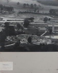 Federation University Historical Collection
Photographs - black and white, Ballarat College of Advanced Education, Aerial views of the Mt Helen campus from the north, not dated
... 2 black and white aerial photographs .1) Aerial view of Mt... black and white aerial photographs .1) Aerial view of Mt Helen ...2 black and white aerial photographs .1) Aerial view of Mt Helen campus from the north .2) Aerial view from the northmount helen campus, mount helen campus aerial, student residences -
 Ringwood and District Historical Society
Photograph, Aerial photograph of Ringwood - 1962
... Aerial photograph of Ringwood - 1962...Typed below photograph, "Aerial photograph of Ringwood... Road Ringwood North melbourne Typed below photograph, "Aerial ...Typed below photograph, "Aerial photograph of Ringwood. 1962. Old Ringwood Reserve now site Eastland can be seen top left-hand corner". -
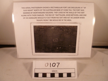 National Vietnam Veterans Museum (NVVM)
Photograph - Photograph, Suoi Nghe, 7RAR
... the photograph reads: This aerial photograph shows a rectangular fort...This aerial photograph shows a rectangular fort like... signals This aerial photograph shows a rectangular fort like ...A reprinted black and white Photograph of an area with a small rectangle area in the middle and the road goes down from below middle left side to near bottom on the right side. Above the photograph reads: This aerial photograph shows a rectangular fort like enclosure at "Ap Suoi Nghe" North of the Australian Base at Vung Tau. the fort was manned by Montagnard soldiers who lived with their families within the walls of the village. The RSO of 7 Battalion, John Methven, and one of his signalers would fly out from Nui Dat and act as liaison when troops from 7 BN would be in the area.This aerial photograph shows a rectangular fort like enclosure at "Ap Suoi Nighe" north of Australian base at Vung Tau. The fort was manned by montangard soldiers. They lived in the walls of the fort along with their families. The RSO of 7 Battalion, John Methven and one of his signalers would fly out from Nui Dat and act as liaison when troops from 7 BN woul be in the area.7 rar, 7 battalion map, john methven, montagnard, suoi nghe, signals -
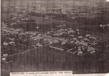
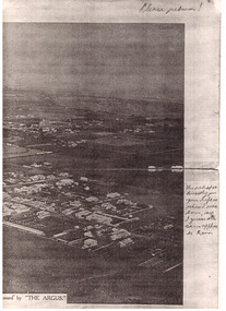
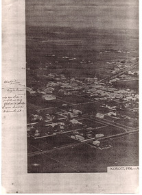 Koroit & District Historical Society
Koroit aerial shot
... photograph. Aerial photograph of Koroit 1936. Writing would probably... of a black and white photograph. Aerial photograph of Koroit 1936 ...PAR0001 to PAR0003 Photocopy of a black and white photograph. Aerial photograph of Koroit 1936. Writing would probably be by Rhoda Hindhaugh formerly Stevenson nee Barr. Souvenir aerial photograph taken by The Argus newspaper 1936. The buildings have been named in pen entered at a later date. -
Glenelg Shire Council Cultural Collection
Photograph - Photograph - Aerial shot of rock wall Dutton Way, n.d
... Photograph - Aerial shot of rock wall Dutton Way...Coloured aerial photograph of the rock wall & groynes... aerial photograph of the rock wall & groynes at Dutton Way. Taken ...Port of Portland Authority Archivesport of portland archives, dutton way -
Port Melbourne Historical & Preservation Society
Photograph - Aerial view of West Gate Bridge, Oct 1990
... Page from 1990 City of Melbourne Strategy Plan with aerial... photograph of West Gate Bridge and Fishermen's Bend Photograph Aerial ...Cut from the 1990 City of Melbourne Strategy PlanPage from 1990 City of Melbourne Strategy Plan with aerial photograph of West Gate Bridge and Fishermen's Bendtown planning, engineering - bridges -
Port Melbourne Historical & Preservation Society
Photograph - Aerial view over Yarra River and Port Melbourne, 18 Jun 1940
... Aerial photograph overlooking the Yarra River with Port... moore ltd north wharf south wharf nordfest Aerial photograph ...Aerial photograph overlooking the Yarra River with Port Melbourne in the middle. Background - Williamstown Road is visible at the top of the picture.piers and wharves - miscellaneous, built environment - commercial, malcolm moore ltd, north wharf, south wharf, nordfest -
Tatura Irrigation & Wartime Camps Museum
Photograph - aerial, Arthur J. Underwood, Kyabram, Tatura 1959, January 1959
... Photograph - aerial...Black and white aerial photograph of Tatura township taken... Press J. Underwood Black and white aerial photograph of Tatura ...J. Underwood was photographer for Kyabram Free PressBlack and white aerial photograph of Tatura township taken in 1959 by J. Underwood, Kyabram. Framed and under glass.j. underwood -
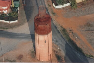 Rutherglen Historical Society
Photograph - Aerial Images, c2000
... Colour aerial photograph of the old Rutherglen water tower... on top to make it look like a wine bottle. Photograph Aerial ...The Rutherglen 'Big Wine Bottle', once a water tower to supply the town's water, is now kept as a tourist attraction.Colour aerial photograph of the old Rutherglen water tower with the structure on top to make it look like a wine bottle.water tower, water supply, rutherglen winebottle -
 Ballarat Heritage Services
Digital photographs, L.J. Gervasoni, Kew from the Air, c2014
... Colour aerial photograph of the Melbourne Suburb of Kew... aerial Colour aerial photograph of the Melbourne Suburb of Kew ...Colour aerial photograph of the Melbourne Suburb of Kew taken from an aeroplane coming into land at Tullamarine Airport, Melbourne. melbourne, kew, hawthorn, camberwell, landscape, aerial -
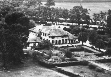 Stawell Historical Society Inc
Photograph, “Warranooke” Homestead in Glenorchy 1867 -- aerial view
... Black and white aerial photograph of building showing...” Homestead in Glenorchy 1867 -- aerial view Photograph ...Aerial View of “Warranooke” Homestead. “Warranooke” Homestead built 1867 enlarged 1926. Shows extensive gardens at front. A very early property in our district Warranooke The main names associated with the property Ayrey - Darnell - Nicoll, later Campbell. Mrs. Campbell built Charles Ayrey's daughter. The Campbells built up the station buildings. The homestead was virtually rebuilt in brick, making it one of the largest and most elaborate in the East Wimmera. Warranooke homestead built 1867, enlarged 1926 destroyed by fire 13th Feb. 1979.Black and white aerial photograph of building showing landscape around the homestead. The photo is on a card with some gold decorations.glenorchy -
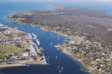 Lakes Entrance Historical Society
Photograph - McMillan Strait, 2005 c
... Aerial Photograph...Colour aerial photograph of McMillan Strait between...Aerial Photograph Township Colour aerial photograph ...Colour aerial photograph of McMillan Strait between Paynesville on left and Raymond Island on right on Gippsland Lakes Victoriaaerial photograph, township -
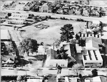 Stawell Historical Society Inc
Photograph, Stawell Technical School Aerial Photograph
... Stawell Technical School Aerial Photograph...Stawell Technical School Aerial Photograph...Stawell Technical School Aerial Photograph stawell ...Stawell Technical School Aerial Photographstawell education -
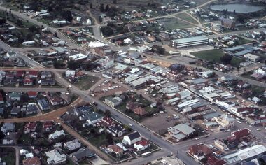 Stawell Historical Society Inc
Photograph - Slides, Ian McCann, Aerial View 1976, 1976 - 1984
... Aerial Colour Photograph of Stawell... grampians Aerial Colour Photograph of Stawell Aerial View 1976 ...Aerial Colour Photograph of Stawell -
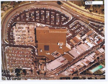 Greensborough Historical Society
Aerial Photograph, Greensborough Plaza Aerial View, 1979c
... Aerial Photograph...Early aerial photograph of Greensborough Plaza, 1970.... Plenty Lower Plenty melbourne Early aerial photograph ...Early aerial photograph of Greensborough Plaza, 1970.Colour photocopy of aerial survey, laminatedgreensborough plaza