Showing 16065 items
matching area
-
 Ringwood and District Historical Society
Research Folder, Collection of Sands MacDougall Directories (Digital), Ringwood area: Uncatalogued
Directory containing images of Sands & MacDougall Directories pages for Ringwood, Croydon, Ringwood east etc.: 1947, 1958, 1968, 1971, 1972, 1973, 1974 -
 Ringwood and District Historical Society
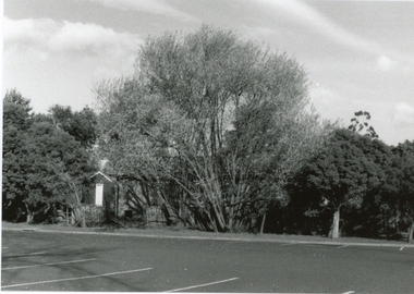
Photograph, Parking area at the rear of the old Ringwood Library in Pratt St, Ringwood on 10 September 1989
Digital photograph -
 Kiewa Valley Historical Society
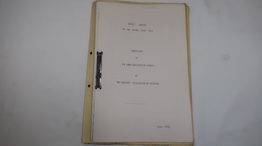
Folder - Cattle Grazing, Cattle Grazing in the Alpine Study Area
Cattlemen / Beef Farmers of the Kiewa Valley took their cattle up to the High Plains to graze during summer.Cover includes the heading 'National Parks Service' and is bound on the spine with black tape. This is followed by 'File Title' on yellow cardboard marked with column and lines. Inside: 35 pages printed on one side. Pages are bound by steel binder. Dated: June 1978J. Commins on cover page at the top.bogong high plains, cattle grazing, farmers of the kiewa valey, national parks -
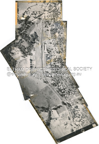
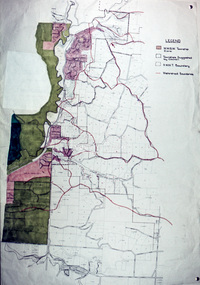
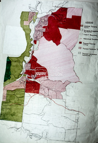
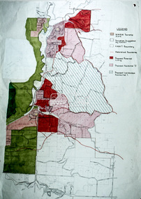
![Book - Map, Land Conservation Council, Melbourne Study Area Report, [December 1973]](/media/collectors/4f729f7b97f83e03086018a5/items/6469bc241d76dd4b008a829f/item-media/646b0013d841f8920fa4323c/item-fit-380x285.jpg) Eltham District Historical Society Inc
Eltham District Historical Society IncBook - Map, Land Conservation Council, Melbourne Study Area Report, [December 1973]
The Melbourne Study Report is a series of volumes describing the physical nature of the land and its environment, examines the likely forms of land use, and assesses the hazards associated with these uses. This is Volume 2 (coloured maps). The first page featues a black and white map described as "Shire of Diamond Valley" with public land marked in yellow. Followed by eight large fold out maps. Melbourne Study Area Public land and descriptive blocks, Population description, Geology, Physiography, topography and rainfall, vegetation and water supply. The Land Conservation Act 1970 established the Land Conservation Council whose functions is to "carry out investigations and make recommendations to the Minister with respect to the use of public land in order to provide for the balanced use of land in Victoria. This report sets out to describe and assess the natural resources of the public lands in the Melbourne area and provides a factual basis on which members of the community may base submissions to the [Land Conservation] Council of Victoria.A collection of eight large fold out coloured maps published in a bound book formnon-fictionThe Melbourne Study Report is a series of volumes describing the physical nature of the land and its environment, examines the likely forms of land use, and assesses the hazards associated with these uses. This is Volume 2 (coloured maps). The first page featues a black and white map described as "Shire of Diamond Valley" with public land marked in yellow. Followed by eight large fold out maps. Melbourne Study Area Public land and descriptive blocks, Population description, Geology, Physiography, topography and rainfall, vegetation and water supply. The Land Conservation Act 1970 established the Land Conservation Council whose functions is to "carry out investigations and make recommendations to the Minister with respect to the use of public land in order to provide for the balanced use of land in Victoria. This report sets out to describe and assess the natural resources of the public lands in the Melbourne area and provides a factual basis on which members of the community may base submissions to the [Land Conservation] Council of Victoria. maps, shire of diamond valley, population, geology, topography, rainfall, vegetation, water supply, land use, public lands -
 Eltham District Historical Society Inc
Document - Series Listing, Fraser Faithfull et al, Series 19: Eltham Shire Offices, Entertainment Area Refurbishment, 16 colour photographs, 2000
Series consists of 16 colour photographs of contractors at work inside the Shire Offices. Includes photographs of CEO Rodney Roscholler and Cr Mary Grant.shire of eltham archives, series listing -
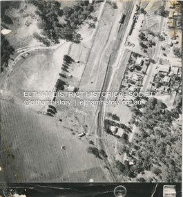
 Eltham District Historical Society Inc
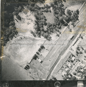
Photograph - Aerial Photograph, Main Road, Hurstbridge; Rose Road to Anzac Avenue including Railway Station area, 12 Apr. 1954
Victorian Railways Aerial Surveyshire of eltham archives, aerial photo, main road, anzac avenue, hursbridge, parker road, hurstbridge railway station, rose road -
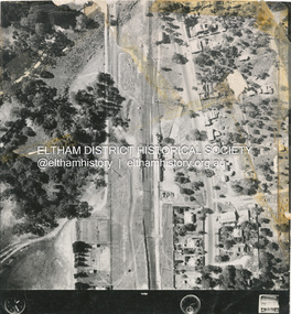
 Eltham District Historical Society Inc
Photograph - Aerial Photograph, Main Road and Railway Station area, Hurstbridge, 12 Apr. 1954
Victorian Railways Aerial Surveyshire of eltham archives, aerial photo, main road, anzac avenue, hursbridge, parker road, hurstbridge railway station, rose road -
 Eltham District Historical Society Inc
Photograph - Aerial Photograph, Main Road and Railway Station area, Hurstbridge, 12 Apr. 1954
Victorian Railways Aerial Surveyshire of eltham archives, aerial photo, main road, anzac avenue, hursbridge, parker road, hurstbridge railway station, rose road -
 Eltham District Historical Society Inc
Photograph - Aerial Photograph, Main Road and Railway Station area, Hurstbridge, 12 Apr. 1954
Victorian Railways Aerial Surveyshire of eltham archives, aerial photo, main road, anzac avenue, hursbridge, parker road, hurstbridge railway station, rose road -
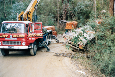
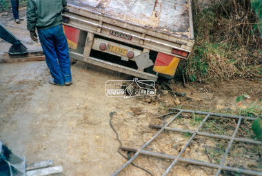
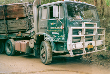 Eltham District Historical Society Inc
Photograph - Colour Print, Salvage operation in the Henley Road area Kangaroo Ground, c.1990
A truck operated by G.W. Glenn Road Transport Pty Ltd of Moama, NSW was transporting a load of sleepers and wood posts along Henley Road, Kangaroo Ground. As a result of signioficantly wet conditions, the truck became disabled when the trailer slipped off the verge of the unsealed muddy road whilst negotiating a hairpin bend. The load was removed from the trailer by Jet Cranes in order to facilitate pulling the trailer back on to the road.g.w. glenn road transport pty ltd, henley road, jet cranes, kangaroo ground, salvage operation, trucks, llc543 (vic. regn.), nv05ai (fedl hv regn.) -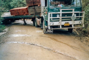
 Eltham District Historical Society Inc
Photograph - Colour Print, Unidentified, possibly Eltham area, c.1980
On reverse - Ex 5landscape, parks and gardens, unidentified -
 Eltham District Historical Society Inc
Slide - Photograph, Eltham Shire Council, Hurstbridge area, Melbourne Metropolitan Planning Scheme, Amendment No. 21, Melbourne and Metropolitan Board of Works, Apr 1972
35mm colour positive transparency blue Agfacolour Service plastic mountmap, melbourne metropolitan board of works, mmbw, planning proposals, shire of eltham, planning -
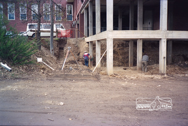 Eltham District Historical Society Inc
Photograph, Construction works to fit out lower area of Eltham Shire Offices, 895 Main Road, c.1986, 1986c
CEO office to right lunch room below bef 1987Roll of 35mm colour negative film, 4 strips Fuji 100-Seltham shire office, municipal offices, shire of eltham, shire offices, construction -
 Eltham District Historical Society Inc
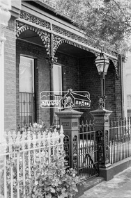
Photograph, George Coop, A day in Melbourne, a Victorian terrace building in the area of Cardigan Street, Carlton, November 1962, 1962
Digital TIFF file Scan of 35mm Ilford FP3 black and white transparencycardigan street, carlton, houses, melbourne, victorian terrace -
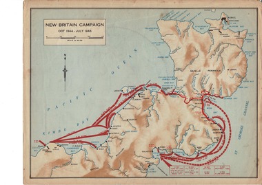 Lara RSL Sub Branch
Map, World War 2 Borneo Area, 1945
Military maps of Australian Campaigns in the Borneo area World War 2paper coloured maps from unknown bookMap 1 Centre section opened - North Borneo Campaign June - July 1945. Closed Side 1 - Tarakan Campaign 1 May - 21 June 1945. Side 2 Balikpapan Campaign July 1945 Map 2 Centre section opened - Aitape-Wewak Campaign Nov 1944 - Aug 1945. Closed Side 1 Bougainville Campaign Nov 1944 - June 1945 New Britain Campaign Oct 1944 - July 1945borneo new britain bougainville wewak maps ww2 -
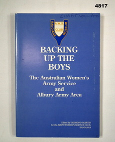 Bendigo Military Museum
Book - ARMY HISTORY, The Australian Women's Service Club, Backing Up The Boys: The Australian Women's Army Service and Albury Army Area, 1988
The book details the history of the Australian Women's Army Service and the Albury Army AreaBlue coloured soft cover with the title in white lettering. A blue and white crest with yellow lettering is located at the top centre of the front cover. A larger version of the same crest is located in the centre of the back cover. 143 pages with cut edges and black and white photographs and illustrations.non-fictionThe book details the history of the Australian Women's Army Service and the Albury Army Areaaustralian women's army service, bandiana museum, albury army area, major thomas b. williams, army history -
Federation University Historical Collection
Ballarat's Humffray Street Area
Foolscap photocopyhumffray street -
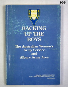 Bendigo Military Museum
Book, The Army Women's Service Club, Backling up the Boys. The Australian Women's Army Service and Albury Army Area, 1988
Book, soft cardboard cover, white colour print on front, AWS Club Bandiana Museum emblem on front & back, light blue colour background, 144 cut, plain pages, illustrated black & white photographs.women's service, books, military history -
Phillip Island and District Historical Society Inc.
Book, EDGECOMBE, Jean, Lord Howe Island, world heritage area, 1987
natural history, lord howe island, description, travel, history -
![Newspaper - Newspaper Clipping, Diamond Valley News; Diamond Valley Leader, Christmas services [Greensborough area 1995, 1999, 2003], 1995-2003](/media/collectors/4f729f5697f83e03086015b8/items/6614c893db03b3f80cf83482/item-media/6625f9e050484b6c0f120d91/item-fit-380x285.jpg) Greensborough Historical Society
Greensborough Historical SocietyNewspaper - Newspaper Clipping, Diamond Valley News; Diamond Valley Leader, Christmas services [Greensborough area 1995, 1999, 2003], 1995-2003
List of Christmas services in 1995, 1999 and 2003 in Diamond Valley churches, including times and places.Three newspaper clippings from Diamond Valley Leader and Diamond Valley News, Text and illustrations.christmas services, greensborough inter church council -
 Phillip Island and District Historical Society Inc.
Newspaper Clipping, PI: No Milk Board Area, 31/11/1968
Article from a collection of newspaper clippings from October 1968 to July 1971Article re councillors voting against Phillip Island's dairy farmers coming under the Milk Board.phillip island, phillip island dairy farmers, milk board, cr. hobbs -
![Newspaper Clipping - Digital Image, Area students join stage extravaganza [Greensborough Primary School Gr2062], 08/09/1999](/media/collectors/4f729f5697f83e03086015b8/items/5bb87f5f21ea6716dc3dfde3/item-media/5bb87fad21ea6716dc3e58fb/item-fit-380x285.jpg) Greensborough Historical Society
Greensborough Historical SocietyNewspaper Clipping - Digital Image, Area students join stage extravaganza [Greensborough Primary School Gr2062], 08/09/1999
Students from Greensborough Primary School participated in the Education Department performance 'Dreamscape'.Newspaper clipping, black and white text and colour image.greensborough primary school -
![Photograph - Digital image, Loyola Seminary 7 [Aerial view with Surrounding Area] 1934, 1934_](/media/collectors/4f729f5697f83e03086015b8/items/54b9eba92162f1091870c075/item-media/54b9ebf22162f1091870c374/item-fit-380x285.jpg) Greensborough Historical Society
Greensborough Historical SocietyPhotograph - Digital image, Loyola Seminary 7 [Aerial view with Surrounding Area] 1934, 1934_
Part of a collection of photographs of the Jesuit Seminary in Grimshaw Street Watsonia. Opened in 1934, this was a house of formation and study for the Society of Jesus. Loyola College (established 1980), now occupies the site and purchased the original building in 2002.Digital copy of black and white photograph.loyola seminary watsonia, loyola college -
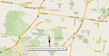 Greensborough Historical Society
Map, Overlay/comparison Map for 1868 Greensborough-Bundoora Geological Map area, 1868_
This map is a comparison to the map at Item 2518, questioning the location of "Sugar Loaf". Annotation by GHS member Ian Bryant.Map copied from Google maps.Annotation on map.sugarloaf hill, bundoora, greensborough - maps -
 Greensborough Historical Society
Photograph - Digital image, Frank Solomon, Pig Farm, Weidlich Road area: aerial view, 02/08/2009
An aerial view of the pig farm in Weidlich Road Greensborough, owned by Werner Hanusch. The land was used as a pig farm and quarry from 1954 and has now been subdivided into the Evelyn Way estate. This project of fifty, one double storey, dwellings was commenced on 2/8/2009 and completed on 6/2/2011.An example of the changing land use in Greensborough, from farming to residential.Digital copy of aerial photographwerner otto fritz hanusch, pig farm st helena, weidlich road greensborough, one evelyn way greensborough