Showing 1418 items
matching bending
-
 Eltham District Historical Society Inc
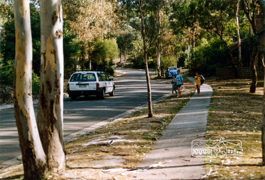
Photograph, Looking southwest along Dunstan Drive, Hurstbridge, c.1992, 1992c
Milton Way on the left and Carlysle Close on the right at the bend. Dunstan Reserve on right.Colour photographstreets, carlysle close, dunstan drive, dunstan reserve, hurstbridge, milton way -
 Eltham District Historical Society Inc
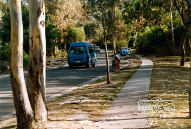
Photograph, Looking southwest along Dunstan Drive, Hurstbridge, c.1992, 1992c
Milton Way on the left and Carlysle Close on the right at the bend. Dunstan Reserve on right.Colour photographstreets, carlysle close, dunstan drive, dunstan reserve, hurstbridge, milton way -
 Eltham District Historical Society Inc
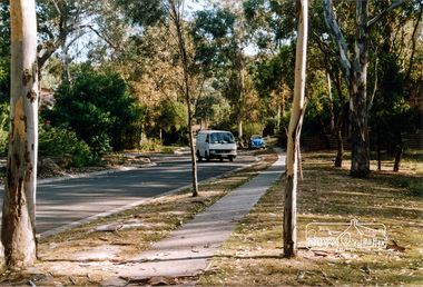
Photograph, Looking southwest along Dunstan Drive, Hurstbridge, c.1992, 1992c
Milton Way on the left and Carlysle Close on the right at the bend. Dunstan Reserve on right.Colour photographstreets, carlysle close, dunstan drive, dunstan reserve, hurstbridge, milton way -
 Eltham District Historical Society Inc
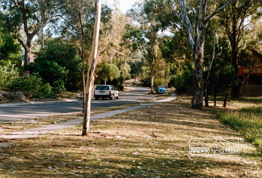
Photograph, Looking southwest along Dunstan Drive, Hurstbridge, c.1992, 1992c
Milton Way on the left and Carlysle Close on the right at the bend. Dunstan Reserve on right.Colour photographstreets, carlysle close, dunstan drive, dunstan reserve, hurstbridge, milton way -
 Moorabbin Air Museum
Booklet (item), Report SM.65: Temperature Measurements on a Beaufort Aircraft during Summer at Alice Springs and Melbourne
Previously owned by the technical library at Government Aircraft Factories, Fishermen's Bend, Melbourne -
![Outcasts, Mists and Shadows: a short history of institutional care around Yarra Bend, Melbourne / [by] Colin Briton](/media/collectors/550653872162f11fb04854aa/items/5ece5ebef36c2704c4f2a625/item-media/5ece5f9af36c2704c4f2a709/item-fit-380x285.jpg) Kew Historical Society Inc
Kew Historical Society IncBook, Colin Briton, Outcasts, Mists and Shadows: a short history of institutional care around Yarra Bend, Melbourne, 2019
History of institutional care in Yarra Bend Park and Studley Park by Colin Briton.[Northcote, Victoria] : Colin Briton, [2018] ©2018 v, 118 pages, 11 pages of plates : illustrations, maps ; 21 cm non-fictionHistory of institutional care in Yarra Bend Park and Studley Park by Colin Briton.institutional care -- victoria -- melbourne -- history., health facilities -- victoria -- melbourne -- history, asylums -- victoria -- melbourne -- history., reformatories for women -- victoria -- melbourne -- history. -
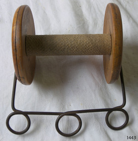 Flagstaff Hill Maritime Museum and Village
Functional object - String Dispenser, mid-19th century
This dispenser was most likely used for holding and dispensing string. It was used in the Cramond and Dickson store, which operated in Warrnambool from 1855 + 1974. John Glass Cramond and James Dickson migrated from Scotland to Melbourne where they opened a Cramond and Dickson store in St Kilda. They were inspired by the growth in Warrnambool after a visit and opened a second store there in 1855. The Cramond and Dickson store, grocers – drapery – ironmongery - chemist, was located on the corner of Liebig and Timor Streets, Warrnambool (now the site of a Mexican restaurant). Both Cramond and Dickson were involved in the business and social aspects of Warrnambool’s community. Cramond and Dickson closed in 1974. An advertisement placed by Cramond and Dickson in The Camperdown Chronicle, Saturday 6th April 1895, states them “showing the latest novelties for the coming winter season” … “import directly from English and Continental manufacturers” … “representatives in London … always in touch with the Newest Continental Fashions” ... “having been established for so many years we know the requirements of the Western District”… “allow 5 percent discount on goods paid for at the time of purchase”. [references: local historian John Lindsay, Warrnambool City Council’s CBD Heritage Trail leaflet, The Camperdown Chronicle, Facebook “Lost Warrnambool” site; WDHS Journal Volume 49 No2 2015] The string dispenser is significant for being used at the local historical Cramond and Dickson department store in Warrnambool It is also of significance as it is an example of office equipment used in many stores for the wrapping and securing of parcels.Dispenser for string; spindle, reel or spool with cylindrical axle in centre, a wooden disc at each end. A length of wire is attached to each end and bend into a 'U' shape, with three loops formed across the base of the 'U'. Item came from Cramond and Dickson store in Warrnambool and was possibly used for dispensing string, with the wire being used as a handle or for mounting.flagstaff hill, warrnambool, shipwrecked-coast, flagstaff-hill, flagstaff-hill-maritime-museum, maritime-museum, shipwreck-coast, flagstaff-hill-maritime-village, dispenser, string dispenser, cramond and dickson, department store, office equipment, commerce, packaging -
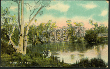 Kew Historical Society Inc
Postcard, AWR&Co, Scene at Kew, c.1907
Colourised pictorial postcard of the Zig-Zag Bridge at Kew. In the foreground is a rowboat in which a man is standing, behind whom are two women in hats and a young child. The man appears to be pushing the boat away from the Bank. In the distance is the wooden Zig-Zag Bridge, constructed in the 1870s to link the Yarra Bend and Kew Lunatic Asylums. [Destroyed by flood, 1929.]Text to Mrs Cooper from Grace ? inscription dated to 1907zig-zag bridge, yarra river -- kew (vic.), postcards -
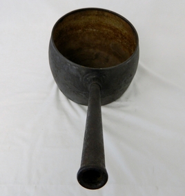
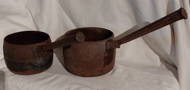 Mont De Lancey
Domestic object - Saucepans, C.Clark & Co, 1900's
This large deep pan (with a long handle) was used by pioneer families, mainly rural folk, that needed a pan which could cope with an open fire heat source, in or mainly outside the homestead. This pan was used in the early to late 1900's for the stews and other meals required by hard working stockmen and farmers that had irregular lunch and dinner or tea breaks under sometimes hard and gruelling conditions. Hot plates were normally not in use.Two vintage black sooted heavy cast iron cooking pots or saucepans with rounded sides and long straight fluted handles angled at approximately sixty degrees upwards. This angle ensured that both distance from flame intensity and least bending of knees when lifting is at a minimum. It was used on the open fire or on a wood fired stove, possible on the fire direct.'6 pints' has indecipherable inscription. On the back of the '4' pints one - 'C. Clark & Co. R 455279 - Best Quality'cooking equipment, cooking pots, cooking, saucepans, pots, kitchen equipment -
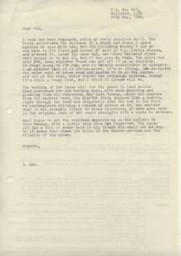 Ballarat Tramway Museum
Document - Letter/s, Dave Macartney, 24/05/1980 12:00:00 AM
Yields information about the construction of trackwork and other Museum infrastructure during 1980.Letter from Dave Macartney to Warren Doubleday, typed on the rear of an Association of Railway Enthusiasts foolscap size train tour booking form for the Albury to Culcairn tour for 20/5/1967. Letter dated 20 May 1980 updates Warren on progress of bending rail, track repairs, purchase of a new Second hand drill and building work.trams, tramways, btps, trackwork, museum -
 Melbourne Tram Museum
Document - Notice, Department of Aircraft Production - Beaufort Division, "Department of Aircraft Production - Beaufort Division", 22/02/1943 12:00:00 AM
Duplicated notice printed on foolscap paper by "Department of Aircraft Production - Beaufort Division", providing information on bus services (Melbourne & Metropolitan Tramways Bus) to Fisherman's Bend from Queens Bridge. Gives details of departure timing for the period 25 to 28th December 1942. Notice detailed 22 Dec. 1942, signed by G. O. Searle as Office Manger.trams, tramways, mmtb, world war 2, fisherman's bend, buses -
 Melbourne Tram Museum
Newspaper, The Age, "Call for $190m tram bridge at Docklands", 19/02/2016 12:00:00 AM
Newspaper clipping from The Age, 19/2/2016, written by Clay Lucas, titled "Call for $190m tram bridge at Docklands", about a report by Port Phillip Council, recommending a lifting bridge over the Yarra. Refers to a AECOMM report, increase in land values. The line would serve the Fisherman's bend area. Quotes the Councillor Mayor, Cr Vosstrams, tramways, bridges, docklands, fishermen's bend -
Moorabbin Air Museum
Album (item) - CAC Folder containing a range of documents - See Description for details
CAC Green Folder containing following articles, CAC Workforce 1936-1980. CAC Facility Locations. CAC Hawker De Havilland International Manufacturing Contracts. Some CAC Future Products & Contracts. CAC Typical Customer List. CAC Man Hours Lost 1978-1979 & 1980. CAC Prime Marketing Objectives. CAC Automatic Flight Control Systems. CAC Fishermans Bend Sector Sales Analysis Fixed 1986 Dollars CAC Active Ship Location By Major Type And Ocean Areas as April 30,1985 CAC Fishermans Bend Sales Revenue And Profit (After Tax) 1978-1986. CAC Fishermans Bend Workload Distribution 1984/5. CAC Fishermans Bend Sales Revenue Distribution 1984/85. CAC Effect Of Local Procurement On Initial Purchase Cost And Life Of Type Cost - Atar Engine. CAC Photo Composite Maintenance Trainer. CAC Product & Services Applicable to RAN New Submarine Programme. CAC Maintenance And Operational Training Task/Study Definition-Development-Fabrication/Manufacture Implementation/Management Infrastructure Ikara MH53E Maintenance Trainers F18A MDSLMP. CAC Torpedo Handling And Stowage System Mine Launch Handling Stowage System. CAC Airconditioning System (Environmental Control) -
 Eltham District Historical Society Inc
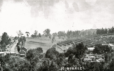
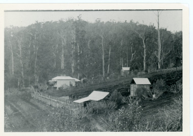
Photograph, Tom Prior, Research
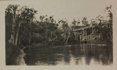
Taken north along Ingrams Road after turning the bend, the area was known for its orchards.The Reynolds family were early settlers in Research. The Reynolds/ Prior collection of photographs were taken by Tom Prior, the maternal uncle of Ivy Reynolds, around 1900 and the 60 photos in the album give a fine overview of many of the landmarks of Research and Eltham over 100 years ago. lvy lived in the family home for many years at 106 Thompson Cres Research. Ivy's father, Ernst Richard Reynolds and grandfather, Richard Reynolds, lived at the same address. Ivy's father Richard worked for Mr. Trail on his property in Research. Reynolds Road is named after the family. Mr Tom Prior (wife Eva) worked at the Melbourne zoo. He was very innovative and made his own camera, using the black cloth hood to exclude the light. The photographs are a reminder of the rural nature of Research and Eltham and its rich heritage. Black and white photograph mounted in an album, the Reynolds/Prior Photograph Collection, this being one of 53 reproduced black and white images of early Eltham.The Reynolds/Prior Photograph Collection, Presented to the Eltham District Historical Society, 14 June 2006 by Ross McDonald. A second copy was also presented to the Andrew Ross Museum, Kangaroo Groundingrams road, orchards, research (vic.), reynolds prior collection -
Moorabbin Air Museum
Document (Item) - Airworthy Certificate for RAAF Wirraway A20-539, Certificate of Safety for Flight
Certificate for A20-539 to declare it fit for its RAAF aceptance flight at Fishermens Bend, Victoria -
 Mt Dandenong & District Historical Society Inc.
Photograph, George Barber's Home Forest Edge after 1912 Looking South West, c1912
George Barber built a homestead later named Forest Edge on Barber's Road and lived there with his wife Sarah Ann (nee Richardson).Black and white photograph showing the side view of a house and three outbuildings. Reverse of photograph has handwritten description by John Lundy-Clarke.George Barber's home on bend of Barber's Road on Lot 25, Village Settlement. Showing passionfruit plantation. Buggy shed top right. Hay shed lower right. Stables, cart shed and men's quarters lower left about 1912. Photo copied by JLC in 1973.forest edge, george barber, sarah ann barber, kalorama, barber's road -
Port Melbourne Historical & Preservation Society
Film - CD-ROM, PMHPS Meeting, Presentation, Gems found at the Public Records Office Victoria, Steve Tserkezidis, 26 Jan 2015
PMHPS meeting 26.01.2015 Powerpoint presentation by Steve Tserkezidis on "gems found at the Public Records Office Victoria". Principally containing images and plans involving State Bank housing estates at Garden City, Fishermen's bend and the Dunstan estate. Images of the State Savings Bank building and Riall print have been separately extracted and entered on the database as cat nos 3468 to 3471 built environment - domestic, built environment - commercial, steve tserkezidis, state savings bank of victoria -
 Kew Historical Society Inc
Photograph - Flood, Zig-Zag, Kew, 1924
Henry Beater Christian (1886-1962) , was a descendant of one of the earliest settler families in Kew. Employed at the Kew Asylum as a 'public servant', he was a skilled amateur photographer, photographing numerous scenes in Kew and on his travels around Victoria. The majority of his photographs date from 1916 to 1929. His finest photographs are housed in two photograph albums. Digital copy of a photograph from page 5 of the 47-page photograph album containing 261 gelatinous silver images, loaned by Diane Washfold with permission given to digitise and hold a copy in our collection. This is a photograph of the river at Kew during a flood in January 1924. The bridge is the Zig-Zag Bridge that linked the Yarra Bend and Kew Asylums (built 1870s-demolished 1929)."Flood / Zig-Zag Kew / 1.24"henry beater christian (1886-1962), landscape photography, kew (vic.) — yarra river, christian-washfold collection, photograph albums, floods -- yarra river -- kew (vic.), zig-zag bridge -
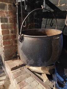 Mont De Lancey
Functional object - Large Boiler, Clark and Co, early 1900's
This large 10 gallon boiler would have been used over an open fire or placed on top of coals to boil clothes clean. They were first made in England during the 1700's and onwards.They were shipped to Australia and other British Empire countries to be purchased by early settlers. A large antique black oval cast iron Boiler Pot with small curved lifting handles for holding it on both sides. There is a large cast moveable carrying iron handle with a bend at the top for hooking onto an 'S' shaped hook or rod to hang over an open fire. This handle is attached on each side to thick iron loops. The Makers name is embossed on one side.Embossed on one side is 'Clarke and Co 10.GS' inside an oval shape (for gallons) There is a diamond shape too of a blacksmith at work. cast iron, cooking, boiling utensils -
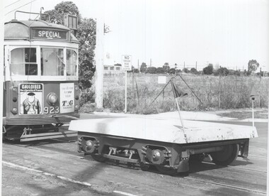 Melbourne Tram Museum
Photograph - Black & White Photograph/s, c1975
Black and White photograph of SW6 923 towing a Z class truck into Miller St tracks alongside Preston Depot - c1975. The truck has a cover over it and has been fitted with two red flags, one of which is bent. The tow bar itself also has a severe bend in it. The tram has adverts for Gauloises cigarettes and T& G Life insurance.trams, tramways, preston workshops, sw6 class, z class, testing, tram 923 -
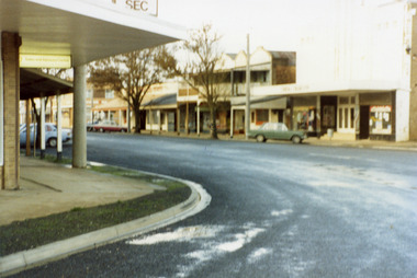 Charlton Golden Grains Museum Inc
Photograph, Charlton Shire, High Street Charlton 1987, c. 1987
Bend in High St looking towards cinema and shops. Charlton Shire High St series 1987Colour photo of High St corner looking towards the shops on the west end and south side of High St. Photo is slightly blurry. Green car parked in front of cinema. SEC sign on top of building at the top of the photo.charlton high st, charlton, rex theatre, business -
Moorabbin Air Museum
Document (Item) - (SP) CAC History Aviation Syndicate Minutes and Agendas 1936
These minutes are very relevant to the setting up of the aircraft manufacturing industry in Australia in Fishermen's Bend 17.2.36 to 28.9.36 -
 Kew Historical Society Inc
Photograph - Zig-Zag Bridge, 1924
Henry Beater Christian (1886-1962) , was a descendant of one of the earliest settler families in Kew. Employed at the Kew Asylum as a 'public servant', he was a skilled amateur photographer, photographing numerous scenes in Kew and on his travels around Victoria. The majority of his photographs date from 1916 to 1929. His finest photographs are housed in two photograph albums. Digital copy of a photograph from page 8 of the 47-page photograph album containing 261 gelatinous silver images, loaned by Diane Washfold with permission given to digitise and hold a copy in our collection. This photograph reveals how the photographer, Henry Christian, positioned himself to take the photograph from the angle in which he was interested. A skilled canoeist, an empty canoe is on the left of the photo that he apparently he used to access his vantage point. His subject, the Zig-Zag Bridge linked the grounds of the Yarra Bend and Kew Asylums. The wooden bridge was constructed in the 1870s and lasted through numerous floods until its destruction in 1929. A horizontal structure, one climbed steps to reach the higher Yarra Bend bank. At the Studley Park end, the bridge descended via a staircase to reach the much lower bank. "Zig-Zag Bridge"henry beater christian (1886-1962), landscape photography, kew (vic.) — yarra river, christian-washfold collection, photograph albums, zig-zag bridge -
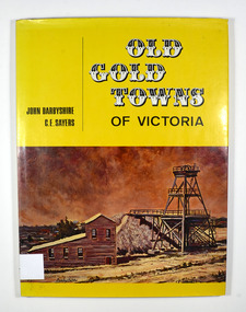 Marysville & District Historical Society
Book, Old Gold Towns of Victoria, 1970
Histories of the old gold towns in VictoriaHardback. Yellow dust cover. Front of jacket illustration-The Diggings, Ballarat. The poppet head, battery house, and mullock heap are typical of an old gold mine, and have been restored on Sovereign Hill over the old North Normandy mine. Back of jacket-The Bend in the Road, at Clunes. Inside both front and back cover is a drawn map of Victoria showing all the towns mentioned in the book. Stamp of the Marysville & District Historical Society Inc / P.O. Box 22 / Marysville 3779 Signature of H M Olivergold town, victoria, australia, history -
 Kiewa Valley Historical Society
Saucepan, circa mid to late 1900's
This large deep pan (with a long handle) was used by pioneer families, mainly rural folk, that needed a pan which could cope with an open fire heat source, in or mainly outside the homestead. This pan was used in the early to late 1900's for the "stews" and other meals required by hard working stock men and farmers that had irregular "lunch and dinner" breaks under sometimes hard and gruelling conditions. Hot plates were normally not in use.This "open fire" saucepan belonged, and was used by a Kiewa Valley, pioneer family, the Roper Family. This saucepan was moved from their Kiewa Valley property to their hut built on the Bogong High Plains. This saucepan was one of an array of "open fire" cooking utensils used in the "camp draft" grazing in the Bogong High Plains and this could take up to six weeks. This kettle belonged and was used by a Kiewa Valley, pioneer family, the Roper Family. This kettle was moved from their Kiewa Valley property to their hut built on the Bogong High Plains. A scientific study started in 1947 to study the impact of grazing cattle on the natural Alpine and sub Alpine vegetation found grazing cattle had an adverse affect on the natural Alpine and sub alpine vegetation, and grazing on the plains was stopped by the Victorian Government in 2005.This large (black, soot infused) cast iron saucepan has a "ten pint" holding capacity and was used on the "open fire", possible on the fire direct. It has a long all metal handle coming from the top half of the pot and angled at approximately sixty degrees upwards. This angle insures that both distance from flame intensity and least bending of knees when lifting is at a minimum.On bottom of pan (underside) "N0. 8 JSJ SIDDONS" on the other side "WEST BROMWICH 5 QUARTS"camp fire cooking utensils, hot plate, cast iron cooking appliance, drovers kitchen -
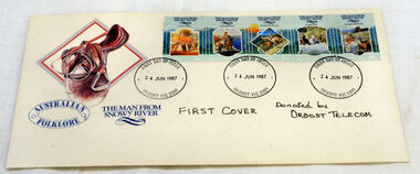 Orbost & District Historical Society
first day cover, Connell, Lee, June 1987
The Man from Snowy River" is a poem by Australian bush poet Banjo Paterson. It was first published in The Bulletin, an Australian news magazine, on 26th April 1890. The poem tells the story of a horseback pursuit to recapture the colt of a prizewinning racehorse that escaped from its paddock and is living wild with the brumbies (wild horses) of the mountain ranges. Eventually the brumbies descend a seemingly impassably steep slope, at which point the assembled riders give up the pursuit, except the young hero, who spurs his pony down the "terrible descent" to catch the mob.Two characters mentioned in the early part of the poem are featured in previous Paterson poems; "Clancy of the Overflow" and Harrison from "Old Pardon, Son of Reprieve".The town of Orbost is situated on the Snowy River and the town has always been "the heart of Snowy River country".A first day cover for "The Man From Snowy River" stamps. There is a picture of a saddle in the top left-hand corner. There is a strip 5 stamps on the envelope and it has been stamped at Orbost Post Office. This strip has 5 scenes based on the Banjo Patterson legendary poem by the same name. The stamps include: At The Station, Mountain Bend, The Terrible Descent, At Their Heels and Brought Them Back.first-day-cover man-from-snowy-river stamps philately -
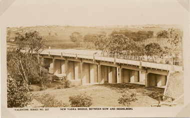 Kew Historical Society Inc
Postcard, Valentine Publishing Co Pty Ltd, New Yarra Bridge, Between Kew and Heidelberg, 1926-1930
Without bridges, Kew remained cut off from the City of Melbourne, only being accessible by Punt. Private and public bridges were constructed from the 1850s, beginning with the Hawthorn Bridge linking Bridge and Burwood Roads. A bridge across the Yarra at Burke Road was created as early as 1873. Since that first wooden bridge, a number of later bridges, typically on concrete pylons have been built, in 1926 and again during the 1970s.Angle view of the new Yarra bridge [ie. The Burke Road bridge] taken from the Kew side, showing the bridge’s structure. Trees line the river’s edge. In the distance can be seen a distant line of houses stretching to the horizon. The river appears to have an S-shaped bend beyond the bridge. The postcard, No. 227, was produced by the Valentine Publishing Co. Pty Ltd., of Queen Street, Melbourne.burke road bridge - kew (vic), bridges - kew (vic) -
Kew Historical Society Inc
Archive (Sub-series) - Subject File, Bowling Clubs, 1958
Various partiesReference, Research, InformationKHS OrderSubject file containing correspondence relating to the former Studley Park Bowling Club in Barry Street, Kew and its relocation to Yarra Bend Park. The file includes a photocopy of the letter by Nigel Lewis to the City of Kew, describing the historic importance of the Club (established c.1903) and the necessity of moving it before demolition. The file has information relating to the pavilion’s move and restoration as an art centre. [ KHS also holds the complete archives of the Auburn Heights Recreation Club (1904-98), the Kew Bowling Club (1880-1998) and the Kew Heights Sports Club (1998-2012). These are separate archives in Provenance Order].sports clubs - kew (vic.), studley park bowling club, urban conservation, heritage protectionsports clubs - kew (vic.), studley park bowling club, urban conservation, heritage protection -
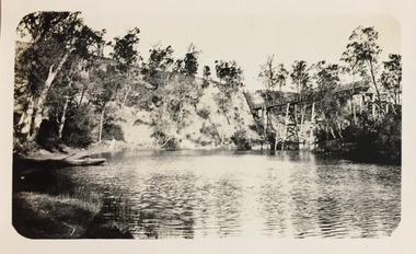
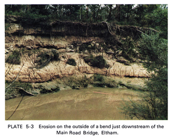 Eltham District Historical Society Inc
Work on paper (Sub-Item) - Photograph, Erosion on the outside of a bend just downstream of the Main Road Bridge, Eltham
Colour photograph of a muddy Diamond Creek (probably after a downpour) with siginificant water erosion apparent at the bend of the creek in Eltham.eltham, creek, vegetation, diamond creek, erosion -
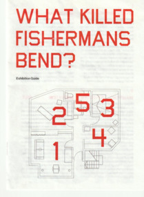 Port Melbourne Historical & Preservation Society
Pamphlet, Paul VAN HERK, What Killed Fishermans Bend?, May 2024
Exhibition guide 'What killed Fisherman Bend' created for Melbourne Design Week 24 May - 2 Jun 2024White folded pamphlet with red title and numbers.fishermans bend