Showing 5271 items
matching dwelling
-
 Bendigo Historical Society Inc.
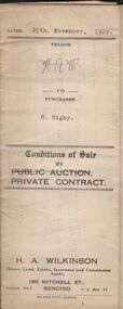
Document - H.A. & S.R. WILKINSON COLLECTION: CONDITION OF SALE
Conditions of sale by private contract dated 25th November, 1929 between H.A. Wilkinson (seller) and R. Rigby (buyer) for land situate corner Bray and Brown Streets, Long Gully, being the land described in miners right as residence area No. 31072, together with 5-roomed weatherboard dwelling and all sundry. Price 95 pounds.organization, business, h.a. & s.r wilkinson real estate -
 Bendigo Historical Society Inc.
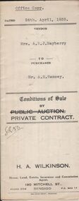
Document - H.A. & S.R. WILKINSON COLLECTION: CONTRACT OF SALE
Conditions of sale by private contract dated 24th April, 1935 between Mrs. A.E.J. Mayberry (seller) and Mr. A.E. Ramsey (buyer) for land situate Spring Gully, Bendigo being land described in certificate of registration residence area No. 33215, together with 5-roomed weatherboard dwelling and all sundry. Price 235 pounds.organization, business, h.a. & s.r wilkinson real estate -
 Bendigo Historical Society Inc.
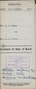
Document - H.A. & S.R. WILKINSON COLLECTION: CONDITION OF SALE
Contract of sale of land dated 28th November, 1952 between Mrs. M.M. Goyne (seller) and Mr. H.A. Pitson (buyer) for land situate No. 140 Lily Street, Bendigo being allotment 21 section 39B described in right to occupy residence area No. 4775, together with weatherboard dwelling and all sundry. Price 1,075 pounds.organization, business, h.a. & s.r wilkinson real estate -
 Bendigo Historical Society Inc.
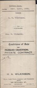
Document - H.A. & S.R. WILKINSON COLLECTION: CONDITION OF SALE
Conditions of sale by private contract dated 23rd April, 1936 between S.R. Wilkinson (seller) and Mrs E. Richards (buyer) for land situate no. 80 Booth Street Golden Square being the land described in right to occupy residence area No. 322, together with 4-roomed weatherboard dwelling and all sundry. Price 220 pounds.organization, business, h.a. & s.r wilkinson real estate -
 Bendigo Historical Society Inc.
Document - H.A. & S.R. WILKINSON COLLECTION: CONDITION OF SALE
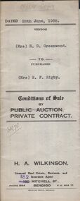
Conditions of sale by private contract dated 28th June, 1938 between Mrs H.D. Greenwood (seller) and Mrs E.F. Rigby (buyer) for land situate No.87 Langston Street, Bendigo, land described in right to occupy residence area No. 179, together with 6-roomed weatherboard dwelling and all sundry. Price 225 poundsorganization, business, h.a. & s.r wilkinson real estate -
 Bendigo Historical Society Inc.
Document - JOAN LEVERSHA COLLECTION: BENDIGO SEWERAGE AUTHORITY PLAN HOUSE DRAINAGE
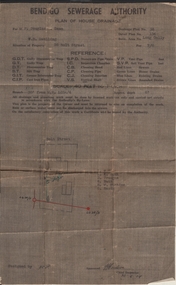
Bendigo Sewerage Authority plan of house drainage for Mr Douglas Dean, situation of property: weatherboard dwelling, 26 Bolt Street, Long Gully. Drainage plan no.35, Detail plan No. 134, retic. area No. long Gully. fee 7/6. Scale 40 feet to 1 inch. Dated 30/08/1954.organisation, government, bendigo sewerage authority -
 Bendigo Historical Society Inc.
Photograph - HARRY BIGGS COLLECTION: THOMAS' BATTERY
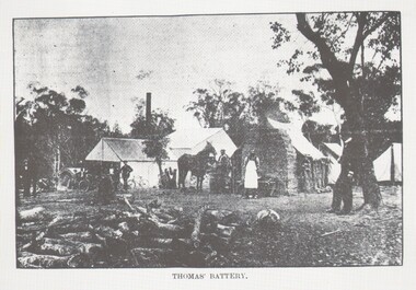
Photograph (proof 74) Thomas' Battery at Wilson's Hill, date unknown. Shows the Battery in the middle distance, there is a very rough timber dwelling with a wide, low, chimney at the end of it and tents to the right of these. A male wearing a white apron is standing in front of the chimney and there is a group of males in front of the Battery building, several bicycles are leaning against the building.topic, mining, battery, thomas battery, wilson's hill, mining -
 Lakes Entrance Historical Society
Photograph - Historic House, 1999
Building reputed to be part of Mrs Carstairs Boarding House at New Works, dismantled and transported to present site.Colour photograph of a timber dwelling at 12 Hunter Street. With hip roof across building, gable at right angles at western.front room. Iron roof, bull nose veranda. Simple timber fringe under veranda roof, timber brackets connect fringe to square veranda posts with lathed pattern in centre. Lakes Entrance Victoriahouses, heritage study -
 Eltham District Historical Society Inc
Slide, Old Eltham Bakery and cottage, cnr of York Street and Main Road, Eltham, c.Jul 1974
The old weatherboard building, possibly dating from the 1860s, comprised a dwelling with a shop in the front room opening off a timber verandah deck which directly fronted the Main Road footpath. At the rear was a brick building of much later date which was for many years used for the bakery. The buildings were demolished in 1979 for construction of flats.35 mm colour positive transparency (x5) Mount - Kodak Kodachrome CardProcessed Jul 1974bakery, eltham, main road, york street -
 Eltham District Historical Society Inc
Slide, Old Eltham Bakery and cottage, cnr of York Street and Main Road, Eltham, c.Jul 1974
The old weatherboard building, possibly dating from the 1860s, comprised a dwelling with a shop in the front room opening off a timber verandah deck which directly fronted the Main Road footpath. At the rear was a brick building of much later date which was for many years used for the bakery. The buildings were demolished in 1979 for construction of flats.35 mm colour positive transparency Mount - Kodak Kodachrome CardProcessed Jul 1974bakery, eltham, main road, york street -
 Greensborough Historical Society
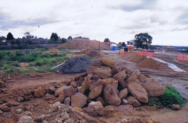
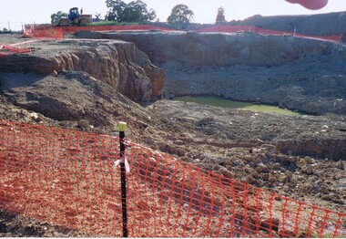
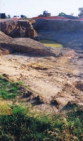
Photograph - Digital image, Frank Solomon, Development of pig farm to residential blocks, 1, 02/08/2009
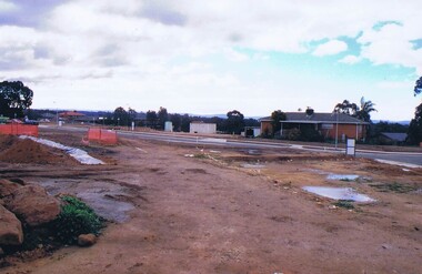
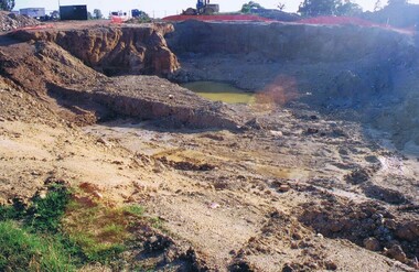
A view of the redevelopment of the pig farm in Weidlich Road Greensborough, owned by Werner Hanusch. The land was used as a pig farm and quarry from 1954 and this photo shows early stages of the land being subdivided into the Evelyn Way estate. This project of fifty, one double storey, dwellings was commenced on 2/8/2009 and completed on 6/2/2011.An example of the changing land use in Greensborough, from farming to residential.Digital copy of colour photographwerner otto fritz hanusch, pig farm st helena, weidlich road greensborough, one evelyn way greensborough -
 Greensborough Historical Society
Photograph - Digital image, Frank Solomon, Development of pig farm to residential blocks, 2, 02/08/2009
A view of the redevelopment of the pig farm in Weidlich Road Greensborough, owned by Werner Hanusch. The land was used as a pig farm and quarry from 1954 and this photo shows early stages of the land being subdivided into the Evelyn Way estate. This project of fifty, one double storey, dwellings was commenced on 2/8/2009 and completed on 6/2/2011.An example of the changing land use in Greensborough, from farming to residential.Digital copy of colour photographwerner otto fritz hanusch, pig farm st helena, weidlich road greensborough, one evelyn way greensborough -
 Greensborough Historical Society
Photograph - Digital image, Frank Solomon, Development of pig farm to residential blocks, 3, 02/08/2009
A view of the redevelopment of the pig farm in Weidlich Road Greensborough, owned by Werner Hanusch. The land was used as a pig farm and quarry from 1954 and this photo shows early stages of the land being subdivided into the Evelyn Way estate. This project of fifty, one double storey, dwellings was commenced on 2/8/2009 and completed on 6/2/2011.An example of the changing land use in Greensborough, from farming to residential.Digital copy of colour photographwerner otto fritz hanusch, pig farm st helena, weidlich road greensborough, one evelyn way greensborough -
 Greensborough Historical Society
Photograph - Digital image, Frank Solomon, Development of pig farm to residential blocks, 4, 02/08/2009
A view of the redevelopment of the pig farm in Weidlich Road Greensborough, owned by Werner Hanusch. The land was used as a pig farm and quarry from 1954 and this photo shows early stages of the land being subdivided into the Evelyn Way estate. This project of fifty, one double storey, dwellings was commenced on 2/8/2009 and completed on 6/2/2011.An example of the changing land use in Greensborough, from farming to residential.Digital copy of colour photographwerner otto fritz hanusch, pig farm st helena, weidlich road greensborough, one evelyn way greensborough -
 Greensborough Historical Society
Photograph - Digital image, Frank Solomon, Development of pig farm to residential blocks, 5, 02/08/2009
A view of the redevelopment of the pig farm in Weidlich Road Greensborough, owned by Werner Hanusch. The land was used as a pig farm and quarry from 1954 and this photo shows early stages of the land being subdivided into the Evelyn Way estate. This project of fifty, one double storey, dwellings was commenced on 2/8/2009 and completed on 6/2/2011.An example of the changing land use in Greensborough, from farming to residential.Digital copy of colour photographwerner otto fritz hanusch, pig farm st helena, weidlich road greensborough, one evelyn way greensborough -
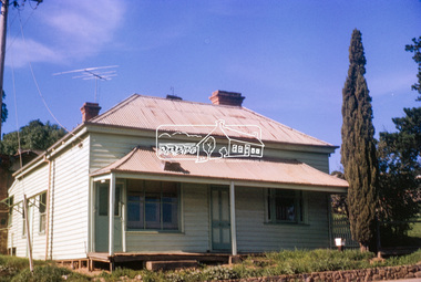
 Eltham District Historical Society Inc
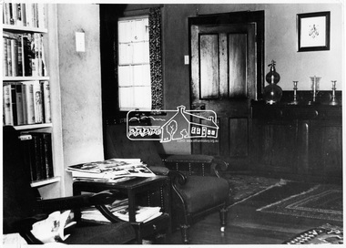
Photograph, Eltham - Interior of the living room at Sweeney's, 1971
Sweeney's, originally Culla Hill, a former homestead, located on a site bought from the crown in 1842 by Irishman Thomas Sweeney. The cottage is important in the history of Eltham and of architectural interest as an example of a Colonial Style dwelling. The Living room shows a wooden door and floor with rug. A window to the left, two seats and a book case. This was the home of V.C. Burston.This photo forms part of a collection of photographs gathered by the Shire of Eltham for their centenary project book, "Pioneers and Painters: 100 years of the Shire of Eltham" by Alan Marshall (1971). The collection of over 500 images is held in partnership between Eltham District Historical Society and Yarra Plenty Regional Library (Eltham Library) and is now formally known as 'The Shire of Eltham Pioneers Photograph Collection.' It is significant in being the first community sourced collection representing the places and people of the Shire's first one hundred years.Digital imagesepp, shire of eltham pioneers photograph collection, eltham, sweeney's cottage, v.c. burston -
 Eltham District Historical Society Inc
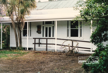
Photograph, Allwood House, Hurstbridge
"Allwood", Hurstbridge, built about 1894 as the second home of the pioneer Hurst family. Frances Hurst married William Gray in 1897. The Grey family would later live in the house. Grey operated Allwood Nurseries. Allwood House, a Victorian-style dwelling is one of the oldest houses in Hurstbridge and now operates as Allwood Neighbourhood House.Colour photograph of Allwood House (now Allwood Neighbourhood House Inc. Community Centre), Hurstbridgeallwood house, hurstbridge, community centres, allwood neighbourhood house -
 Kew Historical Society Inc
Photograph - 264 Cotham Road, 1988
The dwelling is representative of the development of the Georgian Revival style in the 1920s and 30s and its popularity amongst the upper-middle classes as a result of the work of William Hardy Wilson and Professor Leslie Wilkinson. It is of importance as a fine and largely intact designer/builder example of the Georgian Revival style, with American Georgian Revival influences. The dwelling embodies the principal characteristics of the style. American Georgian Revival influences are noted in the deep eaves with modillions, central broken pediment, brick quoins and presentation of the central porch. The garden wall, with arched opening, in the side setback appears to be an early or original landscape feature, based on the comparable brick work detail construction with that of the house. Considering this, it is the only early landscape feature extant which assists in providing some understanding of the original landscape layout of the property. (Criteria D and E) (Boroondara Planning Scheme)Colour photographic positive of 264 Cotham Road, Kew. The residence was constructed in 1931 for the Howitt family. 264 Cotham Road, Kew (HO813) is an individually listed building of significance under Amendment C294 of the Boroondara Planning Scheme. 264 cotham road -- kew (vic.) -
 The Beechworth Burke Museum Research Collection
Card (Series) - Index Card, George Tibbits, 9 Bridge Street, Beechworth, 1976
George Tibbits, University of Melbourne. Faculty of Architecture, Building and Town & Regional PlanningIndex system that support the research for Beechworth : historical reconstruction / [by] George Tibbits ... [et al]Arranged by street names of BeechworthEach index card includes: street name and number of property, image of property, allotment and section number, property owners and dates of ownership, description of the property according to rate records, property floor plan with dimensions.beechworth, george tibbitsbeechworth, george tibbits -
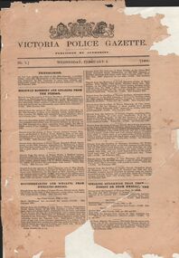 Bendigo Historical Society Inc.
Document - VICTORIA POLICE GAZETTES COLLECTION: GAZETTE FROM FEBRUARY 1881
Victoria Police Gazette No. 5 dated Wednesday, February 2, 1881, containing notices about: incendarism, highway robbery and stealing from the person, housebreaking and stealing from dwelling houses, stealing otherwise than from person or from dwellings, miscellaneous information, horses and cattle, property lost, inquests, murder, deserters from H.M. Service, property found, deserters from merchant vessels, extracts from the South Australian Police gazette, extracts from the Queensland Police gazette, extracts from the New Zealand police gazette and extracts from the New South Wales Police gazette. Also a list of prisoners reported as discharged during the week ending 31st January, 1881. All pages are detached and in very poor condition.essential services, police, victoria police gazette -
 Ringwood and District Historical Society
Photograph, Edwin G. Adamson A.R.P.S, Back grocery, corner Adelaide St Ringwood 1963 (Eastland Litigation Photo) (2 views), May 1963
This series of SS0380 photos are part of the "Eastland Litigation" launched in 1962 by the Whitehorse Traders Co-operative Association (WTCA), against the Ringwood Council's Interim Development Order of 1960. WTCA sought "orders from the Supreme Court of Victoria that the planning scheme was invalid" - See "The Eastland Litigation" chapter in "From Horse Shoes to High Heels - Ringwood Shopping Centre and Eastland 1858-2008" by Richard Carter, Bounce Books 2009.Written on back of photograph 2826-2, 'Back grocery, corner Adelaide St.' Stamped on back, 'Edwin G. Adamson... [and samped] In the Supreme Court 13 Aug 1963'. On back of 2826-1 (similar photo at different time): Photo of the shop and dwelling ordered to be demolished - north-eastern corner of Adelaide St and Maroondah Hwy. -
 City of Kingston
Photograph - Colour, 29 January 1993
Bonbeach, Carrum and Patterson Lakes are suburbs in the City of Kingston. Bonbeach and Carrum were holiday destinations in early 20th century and over time the housing has converted to permanent residential structures. In Patterson Lakes, the area consists predominantly of newer housing developments and the tidal canal system which is accessible to many dwellings joins Port Phillip Bay.Bonbeach, Carrum and Patterson Lakes were previously part of the extensive Carrum Carrum Swamp. The area was once a source of fish and eels for the Mayone-Bulluk clan of the Bunurong people. Over time the area was drained and this allowed farming at Carrum and Bonbeach, although the area was prone to flooding. In the early 1920s and 30s the land was converted to residential dwellings. In 1973 investigations commenced nearby to Bonbeach and Carrum into the development of a unique residential area comprising canals and waterways. It was originally proposed to be known as "Gladesville". Circa 1974, the area was rezoned from rural to residential and named Patterson Lakes. Development has been continuous since the 1970s with staged construction of the waterways, residential housing, and supporting infrastructure and facilities.Laminated colour aerial photograph of the Bonbeach, Carrum and Patterson Lakes region within City of Kingston. This 1993 image includes Bonbeach High School prior to demolition, Bonbeach Primary School and Patterson River Golf Club. Sections of Patterson Lakes are not yet developed, including Rhode and Staten Islands. Long Island Point appears to be a recent development with many spare blocks and new houses under construction. The Patterson River marina is prominent and the river mouth as it meets Port Phillip Bay. The Carrum railway station is visible.Black type on white adhesive sticker: No. 6661 Black type on white adhesive sticker: 26E/6661, 29/1/93, 4.25 pm Black type on white adhesive sticker 29-1-93 Yellow circular adhesive stickerbonbeach, carrum, patterson lakes, patterson river, carrum carrum swamp, canals and waterways -
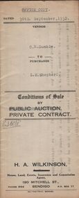 Bendigo Historical Society Inc.
Document - H.A. & S.R. WILKINSON COLLECTION: CONTRACT OF SALE
Conditions of sale by private contract dated 30th September, 1932 between C.R.Dumble (seller) and L,M. Shepherd (buyer) for land situate No.211 Forest Street, Bendigo being part of Crown allotment 367, section K described in certificate of title volume 2540 folio 507813, together with weatherboard dwelling and all sundry. Price 160 pounds.organization, business, h.a. & s.r wilkinson real estate -
 Bendigo Historical Society Inc.
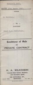
Document - H.A. & S.R. WILKINSON COLLECTION: CONTRACT OF SALE
Conditions of sale by private contract dated 27th March, 1941 between J. Whitley (seller) and Mrs. L.A. Schleiger (buyer) for land situate 243 Queen Street, Bendigo being land described in right to occupy residence area right No. 7313, together with 4-roomed weatherboard dwelling and all sundry. Price 250 pounds. Vendor's copy.organization, business, h.a. & s.r wilkinson real estate -
 Bendigo Historical Society Inc.
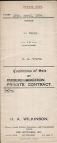
Document - H.A. & S.R. WILKINSON COLLECTION: CONTRACT OF SALE
Conditions of sale by private contract dated 18th April, 1934 between G. Every (seller) and G.A. Tyers (buyer) for land situate White Hills Road, White Hills being part of Crown allotment 8 section 19, described in deed of conveyance No. 426 book No. 497, together with weatherboard dwelling and all sundry. Price 500 pounds.organization, business, h.a. & s.r wilkinson real estate -
 Bendigo Historical Society Inc.
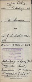
Document - H.A. & S.R. WILKINSON COLLECTION: CONDITION OF SALE
Contract of sale of land dated 3rd May 1954 between Mr.. A. Bruns( seller) and Mr. L.S. Osborne, for land being part of allotment 17 section 129C situate No39 Wattle street, Bendigo described in certificate of title volume 6296 folio 1259099, together with 6-roomed weatherboard dwelling and all sundry. Price 3,925 pounds.organization, business, h.a. & s.r wilkinson real estate -
 Bendigo Historical Society Inc.
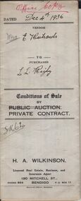
Document - H.A. & S.R. WILKINSON COLLECTION: CONDITION OF SALE
Conditions of sale by private contract dated 4th December 1936 between Mrs Elizabeth Richards (seller) and Leslie Lorraine Rigby (buyer) for land situate no. 80 Booth Street Golden Square being the land described in right to occupy residence area No. 322, together with 4-roomed weatherboard dwelling and all sundry. Price 175 pounds.organization, business, h.a. & s.r wilkinson real estate