Showing 1135 items matching " east kew"
-
 Kew Historical Society Inc
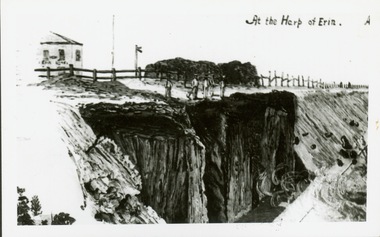
Print, At the Harp of Erin
... the Harp of Erin in Kew East during construction of the Outer...Reverse: " Sketch of blasting near Harp of Erin Hotel, East... Reverse: " Sketch of blasting near Harp of Erin Hotel, East Kew ...Reproduction of newspaper drawing of earthworks near the Harp of Erin in Kew East during construction of the Outer Circle railway.Reverse: " Sketch of blasting near Harp of Erin Hotel, East Kew about 1889 -
 Melbourne Tram Museum
Slide - Set of 2, Warren Doubleday, 9/03/1970 12:00:00 AM
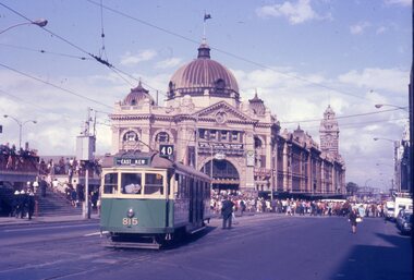
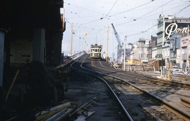
... East Kew... - W5 815 (East Kew, route 40) shunting alongside the Gas...Trams tramways W5 class Route 40 East Kew Flinders St ...Set of 2 Colour slides- Anscochrome plastic mount taken on 9-3-1970 of the shunting of trams for the Moomba Parade Flinders St with the Flinders St Station in the background. .1 - W5 815 (East Kew, route 40) shunting alongside the Gas and Fuel building. An inspector is standing behind the tram. .2 - SW6 939 (North Balwyn, Route 48), shunting in Flinders St with many people alongside. Has adverts for Astoria Rental cars and Houghtons blinds.Has slide number written on itemtrams, tramways, w5 class, route 40, east kew, flinders st, moomba, parades, flinders st station, route 48, north balwyn, tram 815, tram 939 -
 Kew Historical Society Inc
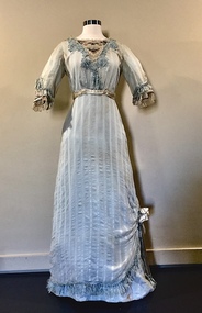
Clothing - Pale Blue Muslin, Silk, & Lace Dress, 1910-14
... east kew presbyterian church... Church [ie the East Kew Presbyterian Church]. Lilian's daughter... Church [ie the East Kew Presbyterian Church]. Lilian's daughter ...The dress was in the cupboard of Muriel Kerr, the donor's recently deceased mother. The donor remembers being shown it and trying it on in the late '70s or early '80s and being told that it belonged to her great-grandmother, Lilian Armstrong Ballantine (nee Power) [1887-1967]. Lilian Ballantine lived at 31 Harp Road (now the site of the Leo Baeck Centre) from the early 1920s to 1967. Lilian's married Archibald Dill Ballantine [1883-1947], in 1910. He was a member of the Monumental firm of A&G Ballantine, responsible for the Kew War Memorial (and possibly the Springthorpe Memorial). Lilian was highly involved with the Finlay McQueen Memorial Church [ie the East Kew Presbyterian Church]. Lilian's daughter, Mary (the donor's grandmother) married Alan McQueen, the son of Finlay McQueen, the first Minister of the East Kew Church. Mary Macqueen lived at 1 Oswin Street; she was a well-known artist. The dress is significant due to its associations with a family with strong connections, through a number of generations, to Kew East and its spiritual institutions. The garment's integrity and design also contribute to its aesthetic significance as a representative item of women's outerwear during the first decades of the twentieth century.Pale blue striped muslin single-piece dress with lace, tulle and embroidery at the neck and on the cuffs. The lace at the neck and cuffs is embroidered with coloured flowers, and edged with tulle. Bordering the v-neckline is a deeper blue guipure lace (possibly added later). There is a satin flower on the right side of the skirt which gathers the hem, exposing the deeper blue cotton underskirt. The dress has a narrow band of blue satin at the high waist. The cotton underskirt is attached by thread in places to the outer layer. Both the outer and under layers are attached with metal hooks and eyes. Edging the cuffs and hem of the dress is blue commercial fringing. The exterior of the dress has a slight brown tinge which is not apparent on the inside hem, suggesting that it has been discoloured through exposure. There are minor stains.women's clothing, edwardian dresses, lilian ballantine, australian fashion - 1910s, mary macqueen, finlay mcqueen memorial church, east kew presbyterian church, alan mcqueen, kew war memorial, archibald dill ballantine, leo baeck centre, 31 harp road -- kew (vic.), a&g ballantine, women's clothing -- 1900s, fashion - 1900s, fashion design -
 Melbourne Tram Museum
Ephemera - Timetable/s, Melbourne & Metropolitan Tramways Board (MMTB), "MMTB bus Timetables", 1970
... East Kew... Collins St. Melbourne. 1 - East Kew - Box Hill - Doncaster - May.... Melbourne. 1 - East Kew - Box Hill - Doncaster - May 1970 - no route ...Set of two bus timetables for specific routes, day of week giving information on tram times at specific time points, route map, sections and fares and organisation address - 616 Little Collins St. Melbourne. 1 - East Kew - Box Hill - Doncaster - May 1970 - no route numbers given. 2 - Fishermen's Bend - City via three different routes - August 1970 Yields information about two MMTB 1970 bus routes.Set of 2 MMTB Tram timetables, folded sheets, 10 sections on white paper.trams, tramways, mmtb, timetables, melbourne, fares, east kew, doncaster, fishermen's bend -
 Kew Historical Society Inc
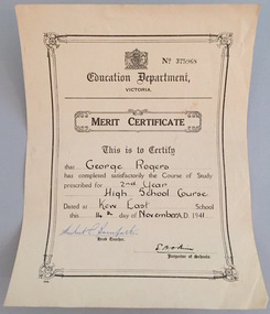
Certificate - School Certificate, Education Department (Victoria), Merit Certificate, George Rogers, Kew East School, 1941, 1941
... Merit Certificate, George Rogers, Kew East School, 1941... prescribed for 2nd Year High School Course, date dat Kew East School... prescribed for 2nd Year High School Course, date dat Kew East School ...George Rogers of Park Crescent, Kew, was the brother of John Rogers, the donor, and the son of Dorothy Rogers.This work forms part of the collection assembled by the historian Dorothy Rogers, that was donated to the Kew Historical Society by her son John Rogers in 2015. The manuscripts, photographs, maps, and documents were sourced by her from both family and local collections or produced as references for her print publications. Many were directly used by Rogers in writing ‘Lovely Old Homes of Kew’ (1961) and 'A History of Kew' (1973), or the numerous articles on local history that she produced for suburban newspapers. Most of the photographs in the collection include detailed annotations in her hand. The Rogers Collection provides a comprehensive insight into the working habits of a historian in the 1960s and 1970s. Together it forms the largest privately-donated collection within the archives of the Kew Historical Society.Education Department of Victoria Merit CertificateEducation Department of Victoria - This is to Certify that George Rogers has completed satisfactorily the course of study prescribed for 2nd Year High School Course, date dat Kew East School this 14th of November A.D. 1941merit certificate, george rogers, education, certificate -
 Kew Historical Society Inc
Plan - Subdivision Plan, Harvest Home Estate, 1919
... subdivision plans - east kew... a subdivision in East Kew. Now, Campbell and Owen Streets on which... of the City of Melbourne. Most of these are of Kew, Kew East ...Pru Sanderson, in her groundbreaking ‘City of Kew Urban Conservation Study : Volume 2 - Development History’ (1988), summarised the periods of urban development and subdivisions of land in Kew. The periods that she identified included 1845-1880, 1880-1893, 1893-1921, 1921-1933, 1933-1943, and Post-War Development. These periods were selected as they represented periods of rapid growth or decline in urban development. An obvious starting point for Sanderson’s groupings involved population growth and the associated economic cycles. These cycles also highlighted urban expansion onto land that was predominantly rural, although in other cases it represented the decline and breakup of large estates. A number of the plans in the Kew Historical Society’s collection can also be found in other collections, such as those of the State Library of Victoria and the Boroondara Library Service. A number are however unique to the collection.The Kew Historical Society collection includes almost 100 subdivision plans pertaining to suburbs of the City of Melbourne. Most of these are of Kew, Kew East or Studley Park, although a smaller number are plans of Camberwell, Deepdene, Balwyn and Hawthorn. It is believed that the majority of the plans were gifted to the Society by persons connected with the real estate firm - J. R. Mathers and McMillan, 136 Cotham Road, Kew. The Plans in the collection are rarely in pristine form, being working plans on which the agent would write notes and record lots sold and the prices of these. The subdivision plans are historically significant examples of the growth of urban Melbourne from the beginning of the 20th Century up until the 1980s. A number of the plans are double-sided and often include a photograph on the reverse. A number of the latter are by noted photographers such as J.E. Barnes.The ‘Harvest Home Estate’ was advertised as being a subdivision in East Kew. Now, Campbell and Owen Streets on which the allotments were located are classed as being in Kew. The Estate included 11 residential allotments abutting the Outer Circle Railway line [at the end of Owen Street]. Understandably, the vendors focused on the availability of transport by tram, noting that the Estate was near the High Street tram terminus at the Harp of Erin. A small note on the subdivision advises that the Cotham Road tram was only 3 minutes away. The location – ‘The most elevated position in lovely Kew’ – was also promoted as an advantage.subdivision plans - east kew, harvest home estate -
 Kew Historical Society Inc
Plan - Subdivision Plan, Violet Farm Estate, 1927
... harp road -- kew east (vic.)... blocks’ on either side of Violet Grove, Kew East. Violet Grove... of the City of Melbourne. Most of these are of Kew, Kew East ...Pru Sanderson, in her groundbreaking ‘City of Kew Urban Conservation Study : Volume 2 - Development History’ (1988), summarised the periods of urban development and subdivisions of land in Kew. The periods that she identified included 1845-1880, 1880-1893, 1893-1921, 1921-1933, 1933-1943, and Post-War Development. These periods were selected as they represented periods of rapid growth or decline in urban development. An obvious starting point for Sanderson’s groupings involved population growth and the associated economic cycles. These cycles also highlighted urban expansion onto land that was predominantly rural, although in other cases it represented the decline and breakup of large estates. A number of the plans in the Kew Historical Society’s collection can also be found in other collections, such as those of the State Library of Victoria and the Boroondara Library Service. A number are however unique to the collection.The Kew Historical Society collection includes almost 100 subdivision plans pertaining to suburbs of the City of Melbourne. Most of these are of Kew, Kew East or Studley Park, although a smaller number are plans of Camberwell, Deepdene, Balwyn and Hawthorn. It is believed that the majority of the plans were gifted to the Society by persons connected with the real estate firm - J. R. Mathers and McMillan, 136 Cotham Road, Kew. The Plans in the collection are rarely in pristine form, being working plans on which the agent would write notes and record lots sold and the prices of these.The subdivision plans are historically significant examples of the growth of urban Melbourne from the beginning of the 20th Century up until the 1980s. A number of the plans are double-sided and often include a photograph on the reverse. A subdivision plan for nineteen ‘bonny, airy building blocks’ on either side of Violet Grove, Kew East. Violet Grove runs between High Street and Harp Road. Like many other subdivisions in Kew and East Kew, older houses (Lots 1 and 13) were often included in the subdivision. Such houses were in some instances the original properties that were subdivided, or in the case of the Violet Grove subdivision, new houses such as the weatherboard villa on lot 13. This villa is advertised as having a tiled roof, 5 rooms, panelled hall, double doors (Rooms 14 x 12 ft. 6 in. (2) 14 x 12, 12 x 11, 13 x 11). A bricked front verandah, a tiled stove recess and existing sewerage connection added to its saleable potential. Water, electric light and power, and gas were all offered as part of the deal. Violet Grove now has about 35 houses, which indicates that the 19 lots of the subdivision were to be further subdivided by purchasers. [A similar plan is in the Batten & Percy Collection of the State Library of Victoria.]subdivision plans - east kew, violet farm estate, violet grove -- kew (vic.), boorool road -- kew (vic.), harp road -- kew east (vic.) -
 Uniting Church Archives - Synod of Victoria
Photograph, c. 1977
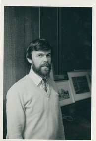
... presbytery; presbyterian minister; uniting church minister; east kew...; East Kew 1970-1976; Stated Clerk Presbyterian Assembly...; then went to New Town Tas 1967-1970; East Kew 1970-1976; Stated ...B 1936 Glasgow arr in Australia 1950 Ordained 1963 First appointment Corryong 1963-1967; then went to New Town Tas 1967-1970; East Kew 1970-1976; Stated Clerk Presbyterian Assembly Of Victoria 1976-1977;Assoc Sec Synod of Victoria 1977-1980; Evangelism Officer Div Field services Synod of Vic 1981-02/87; Interim Exec Sec Field services 03/87-01/89; Presbytery Officer Western Port Presbytery 02/89- 06/95, Executive Secretary VCC 07/95B&W gloss waist length photograph of the Rev. Hamish Christie-Johnston, wearing a jumper and tie. christie-johnston, hamish; synod of victoria; western port presbytery; presbyterian minister; uniting church minister; east kew presbyterian/uniting church; stated clerk presbyterian assembly victoria -
 Uniting Church Archives - Synod of Victoria
Photograph, c. 1970s
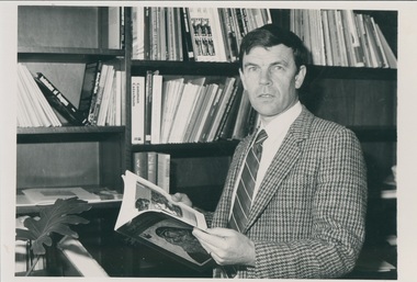
... presbytery; presbyterian minister; uniting church minister; east kew...; East Kew 1970-1976; Stated Clerk Presbyterian Assembly...; then went to New Town Tas 1967-1970; East Kew 1970-1976; Stated ...B 1936 Glasgow arr in Australia 1950 Ordained 1963 First appointment Corryong 1963-1967; then went to New Town Tas 1967-1970; East Kew 1970-1976; Stated Clerk Presbyterian Assembly Of Victoria 1976-1977;Assoc Sec Synod of Victoria 1977-1980; Evangelism Officer Div Field services Synod of Vic 1981-02/87; Interim Exec Sec Field services 03/87-01/89; Presbytery Officer Western Port Presbytery 02/89- 06/95, Executive Secretary VCC 07/95B & W waist length photograph of Rev. Hamish Christie-Johnston seated at a desk, holding an open book. christie-johnston, hamish; synod of victoria; western port presbytery; presbyterian minister; uniting church minister; east kew presbyterian/uniting church; stated clerk presbyterian assembly victoria -
 Kew Historical Society Inc
Photograph - View from the Verandah of 52 Frater Street, Kew
... 52 Frater Street -- Kew East(Vic.)...View from 52 Frater Street, Kew East ... the second half of the 1940s. 52 Frater Street -- Kew East(Vic ...52 Frater Street was the home of the Coade family from the second half of the 1940s. View from 52 Frater Street, Kew East 52 frater street -- kew east(vic.), coade family -
 Kew Historical Society Inc
Plan - Subdivision Plan, Eastlawn Estate, 1914
... subdivision plans - east kew... pleasant Suburb than East Kew for the busy business man. When... and household gardens. subdivision plans - east kew eastlawn estate ...Subdivision plans are historically important documents used as evidence of the growth of suburbs in Australia. They frequently provide information about when the land was sold on which a built structure was subsequently constructed as well as evidence relating to surveyors and real estate and financial agents. The numerous subdivision plans in the Kew Historical Society's collection represent working documents, ranging from the initial sketches made in planning a subdivision to printed plans on which auctioneers or agents listed the prices for which individual lots were sold. In a number of cases, the reverse of a subdivision plan in the collection includes a photograph of a house that was also for sale by the agent. These photographs provide significant heritage information relating house design and decoration, fencing and household gardens.The ‘Eastlawn Estate’ was surveyed and ready for auction in March 1914, three months before the outbreak of World War I. Sixty-six allotments, created on the ‘order of Mr & Miss Preston’ surrounded the mansion of Woodlands in Harp Road. Woodlands formed part of the Estate, being advertised as lot 1. The allotments faced High, Station and Wright Streets, Harp and Normanby Roads, and Woodlands Avenue. Pru Sanderson in the Kew Conservation Study (Vol.2, 1988) wrote that the Eastlawn Estate ‘covered the western half of the failed Harp of Erin Estate’. Contemporary advertisements promoted the Eastlawn Estate as: ‘There will be no more convenient district nor pleasant Suburb than East Kew for the busy business man. When the Electric Tram is laid, he will be able to journey quickly and pleasantly direct from Collins Street to his home in the Eastlawn Estate in about 20 minutes’. The actual plans of subdivision were included in advertisements in The Argus and in the local newspapers.subdivision plans - east kew, eastlawn estate -
 Kew Historical Society Inc
Plan - Subdivision Plan, J R Mathers & McMillan, Willsmere Park Estate, c.1940
... subdivision plans - east kew... and East Kew. The balance of the Estate, and the largest proportion... of the City of Melbourne. Most of these are of Kew, Kew East ...Pru Sanderson, in her groundbreaking ‘City of Kew Urban Conservation Study : Volume 2 - Development History’ (1988), summarised the periods of urban development and subdivisions of land in Kew. The periods that she identified included 1845-1880, 1880-1893, 1893-1921, 1921-1933, 1933-1943, and Post-War Development. These periods were selected as they represented periods of rapid growth or decline in urban development. An obvious starting point for Sanderson’s groupings involved population growth and the associated economic cycles. These cycles also highlighted urban expansion onto land that was predominantly rural, although in other cases it represented the decline and breakup of large estates. A number of the plans in the Kew Historical Society’s collection can also be found in other collections, such as those of the State Library of Victoria and the Boroondara Library Service. A number are however unique to the collection.The Kew Historical Society collection includes almost 100 subdivision plans pertaining to suburbs of the City of Melbourne. Most of these are of Kew, Kew East or Studley Park, although a smaller number are plans of Camberwell, Deepdene, Balwyn and Hawthorn. It is believed that the majority of the plans were gifted to the Society by persons connected with the real estate firm - J. R. Mathers and McMillan, 136 Cotham Road, Kew. The Plans in the collection are rarely in pristine form, being working plans on which the agent would write notes and record lots sold and the prices of these. The subdivision plans are historically significant examples of the growth of urban Melbourne from the beginning of the 20th Century up until the 1980s. A number of the plans are double-sided and often include a photograph on the reverse. A number of the latter are by noted photographers such as J.E. Barnes. In 1910, the Willsmere Park Estate Dairy was lauded in the Box Hill Reporter as ‘an object lesson in dairying’. Ten years later, in 1923, it was to be sold. The first subdivision of the Estate included 77 grand allotments with frontages to Belford and Kilby Roads, Elm and Willow Groves, and Acacia Avenue. Every lot was claimed to be ‘high and dry’, and with panoramic views of Kew and East Kew. The balance of the Estate, and the largest proportion of allotments was to be subdivided and sold from 1940. This second sale included 109 lots fronting Kilby Road and Elm and Willow Groves. Annotations on the plan indicate that the more expensive lots faced Belford Road opposite the Kew Golf Links. Two of these sold for £310. Lots further to the west in Willow Grove were sold for £60 less. Many of the houses to be built on these 109 allotments after the War faced Government restrictions on building materials and the dimensions of each house due to postwar shortages.subdivision plans - east kew, willsmere park estate -
 Melbourne Tram Museum
Slide - Set of 4, John Webster, 16/11/1959 12:00:00 AM
... East Kew... of the first stage of construction. Tram has the destination of East... Bridges W2 class East Kew Route 40 W5 class Route 48 Tram Stops ...Set of four Colour slides, Kodak, white cardboard of trams using the Flinders St overpass of King St, 16-11-59. .1 - W2 538 descending the temporary track over King St as part of the first stage of construction. Tram has the destination of East Kew Route 40. .2 - ditto at the base of the bridge. Tram has adverts for Uncle Toby's Oats, .3 - W5 725 entering the temporary track near Queen St. Tram has destination of Spencer St, route 48 and adverts for 3AW, Pimms No. 1 and Penfolds Wine. On the far right is a MMTB Mk III bus to Kew - Earl St. .4 - ditto with the Yarra Family Hotel in the background. Note the tram stop sign. .In the background are adverts for Penfolds Wines, Bushels, the Flinders St viaduct, Nestles Milk, Girlings Store and the Cafe / Milk bar that was under the viaduct.Hand writing on rear in ink; .1 - 16-11-59 - Melbourne Vic. .2 - ditto ..3 and .4 - 16-11-59 Tram 725 entering temporary track in Flinders St Melbourne Vic.trams, tramways, trackwork, flinders st, king st, track construction, bridges, w2 class, east kew, route 40, w5 class, route 48, tram stops, tram 538, tram 725 -
 Bendigo Military Museum
Administrative record - Intergraph Maintenance Programme for Project "Newhart", Intergraph, Suite 6, 1401 Burke Rd, Kew East 3102, 28 August 1992
... Intergraph, Suite 6, 1401 Burke Rd, Kew East 3102... "Newhart" Intergraph, Suite 6, 1401 Burke Rd, Kew East 3102 ...Intergraph Maintenance by Replacement Proposal (MBR) is the Terms and conditions for the implementation of "Project Newhart" ad the ongoing maintenance of the Automap 2 System. The Document was prepared by Intergraph's Account Manager, Norman John McMurtrie and addressed to LtCol R McHenry, CO Army Survey Regiment.A4 Booklet, Plastic cover, Blue front cover and white rear, Plastic ring binder, RASvy Badge and Text "Intergraph". Pages inserted loose and not secured, includes diagrams and text.royal australian survey corps, rasvy, fortuna, army survey regiment, army svy regt, asr -
 Kew Historical Society Inc
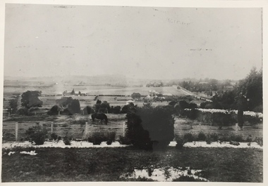
Photograph, Kew looking East to Deepdene, c.1905
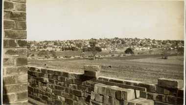
... Kew looking East to Deepdene...Kew looking east towards Deepdene. Before 1909. The reverse... farming (kew) deepdene Kew looking east towards Deepdene. Before ...Kew looking east towards Deepdene. Before 1909. The reverse of the photograph includes an analysis of the photo and the places that can be seen within it (eg Deepdene Station, first Deepdene School, Burke Road etc)farming (kew), deepdene -
 Melbourne Tram Museum
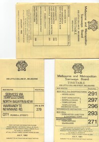
Ephemera - Timetable/s, Melbourne & Metropolitan Tramways Board (MMTB), "MMTB Bus Timetables", 1981 - 1984
... East Kew... East Doncaster, North Balwyn, Kew, Warrandyte, City... East Doncaster, North Balwyn, Kew, Warrandyte, City ...Timetables for specific routes, day of week giving information on tram times at specific time points, route map, sections and fares and organisation address - 616 Little Collins St. Melbourne. All printed on yellow paper. .1 - Timetable for Box Hill via Shoppingtown and Templestowe, Doncaster bus services, dated July 1981 - routes 291, 297, 296, 293 and 271. .2 - Services via Templestowe, North Balwyn and Kew, Warrandyte and Newmans Rd - routes 276, 278 and 279 - July 1982 .3 - Services via East Doncaster, North Balwyn, Kew, Warrandyte, City, Shoppingtown - routes 277, 280, 281 and 268 - dated Jan. 1983 .4 - ditto as above, including Park Orchards and Donvale - routes 265, 262, 261, 260, 266 and 264 - dated Feb. 1983 .5 - North Altona - City Route 232 - April 1984 - issued by Metropolitan Transit with their logo. 6 - Garden City, Port Melbourne - City - Sept 1982 - routes 201, 202 7 - Sunshine - Footscray - City - Routes 230 and 231 - Jan. 1982 8 - North Altona - City - MMTB logo, route 232 - Nov. 1982 9 - East Kew, Box Hill, Doncaster - Express bus - Box Hill to City - routes 284, 270, 300 - April 1982 10 - Ringwood - Warrandyte, Park Orchards, Mitcham - routes 313, 31, 315 and 316 - Jan. 1983Yields information about MMTB Bus services early 1980s and 1 The Met badged item.Set of 9 MMTB and 1 MTA Bus timetables, folded sheets, 8 sections.trams, tramways, mmtb, timetables, melbourne, fares, east kew, box hill, doncaster, north altona, route 232, route 201, route 202, route 220, route 231, route 284, route 270, route 300, route 313, route 314, route 315, route 316 -
 Kew Historical Society Inc
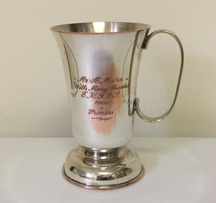
Award - Silver Plate Trophy Cup, 1958-9
... Inscribed East Kew Club premiership trophy cup... / E.K.S.B.T 1960 / Premiers Inscribed East Kew Club premiership trophy ...Arthur Henry Miers played for cricket, football and baseball teams in Kew for a number of decades in the first half of the twentieth century. He was born on 22 November 1901, the son of Rodolph Theophilus Miers (1874-1951) and Margaret Frances (Margaretta) Fry (1875-1958). He had two brothers, Rodolph Cecil Miers (1904-80) and Charles Wilfred Miers (1906-88), and a sister Marjorie Elizabeth Miers (1911-84). Arthur Miers died in Kew on 25 January 1966, and after his body was cremated, his body was interred in the Mausoleum of Boroondara General (Kew) Cemetery.Inscribed East Kew Club premiership trophy cupMr A Miers / With many thanks / E.K.S.B.T 1960 / Premiersarthur henry miers, trophies -
 Kew Historical Society Inc
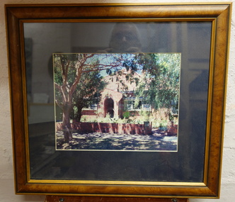
Photograph - Framed Photograph, Red Brick House
... houses - kew - kew east... in Kew or Kew East... houses - kew - kew east Nil Framed and glazed small photograph ...Unidentified house. KHS welcomes viewers to identify the locationFramed and glazed small photograph of a red brick house in Kew or Kew EastNilhouses - kew - kew east -
 Kew Historical Society Inc
Photograph - Yarra Valley at Kew, 1912
... Verso: "Willsmere / East Kew / 1912"...: "Willsmere / East Kew / 1912" Real-photo postcard of the farmland ...During the nineteenth century, the land abutting the south side of the Yarra in Kew was devoted to dairy farming. In the twentieth century, before and after the construction of the Eastern Freeway, much of this low-lying area was used as golf courses and public parks.Real-photo postcard of the farmland in the Yarra Valley in what is believed to be North Kew in 1912. Verso: "Willsmere / East Kew / 1912"yarra river, yarra valley, farming -- kew (vic.) -
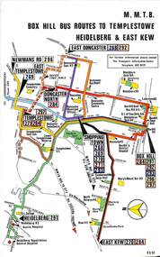 Melbourne Tram Museum
Map, Melbourne & Metropolitan Tramways Board (MMTB), Set of 8 bus route maps, 1977 to 1979
... East Kew... and East Kew, includes Doncaster, Shoppingtown and Newmans Road... Hill Templestowe Doncaster East Kew Heidelberg Clifton Hill ...Series of colour route maps for various bus or groups of tram lines for the MMTB. Some have the Transport Information Centre telephone printed on them, others have a label stuck on. Some are finished with a plastic laminate finish on either one or both sides. Show the major cross streets, parks, schools, other tram routes, major stop numbers and railway lines. .1 - Box Hill bus routes to Templestowe - R38/82, Heidelberg and East Kew, includes Doncaster, Shoppingtown and Newmans Road. .2 - Clifton Hill - R2/79 - Elsternwick, Point Ormond and St Kilda Junction .3 - Footscray, Sunshine, Deer Park, Nth Altona, Fishermen's Bend, Highpoint and Williamstown Road - R2/79. .4 - Bulleen - City - Port Melbourne - Garden City Bus Route, including Kew, Collingwood - R6/78 .5 - City - Warrandyte and East Doncaster including Newmans Road, Templestowe, East Doncaster, Donvale, Shopping town, and Kew. R3/82. .6 - West Heidelberg, La Trobe University, Northland - R3/81 .7 - Box Hill, Ringwood to East Doncaster and Warrandyte, Park Orchards, North Blackburn R3/82. .8 - Geelong - Herne Hill, Rollins Road, Donnybrook Rd, North Shore and Corio Villagetrams, tramways, maps, route guide, route numbers, routes, buses, box hill, templestowe, doncaster, east kew, heidelberg, clifton hill, point ormond, elsternwick, footscray, sunshine, deer park, north altona, fishermen's bend, highpoint, williamstown rd, bulleen, kew, collingwood, port melbourne, garden city, warrandyte, donvale, la trobe university, northland, ringwood, park orchards, mitcham, blackburn, geelong -
 Kew Historical Society Inc
Plan - Subdivision Plan, Boulevard Estate - Boulevard Section, 1930-1936
... Munro Road -- Kew East (Vic.)... of the City of Melbourne. Most of these are of Kew, Kew East ...Pru Sanderson, in her groundbreaking ‘City of Kew Urban Conservation Study : Volume 2 - Development History’ (1988), summarised the periods of urban development and subdivisions of land in Kew. The periods that she identified included 1845-1880, 1880-1893, 1893-1921, 1921-1933, 1933-1943, and Post-War Development. These periods were selected as they represented periods of rapid growth or decline in urban development. An obvious starting point for Sanderson’s groupings involved population growth and the associated economic cycles. These cycles also highlighted urban expansion onto land that was predominantly rural, although in other cases it represented the decline and breakup of large estates. A number of the plans in the Kew Historical Society’s collection can also be found in other collections, such as those of the State Library of Victoria and the Boroondara Library Service. A number are however unique to the collection.The Kew Historical Society collection includes almost 100 subdivision plans pertaining to suburbs of the City of Melbourne. Most of these are of Kew, Kew East or Studley Park, although a smaller number are plans of Camberwell, Deepdene, Balwyn and Hawthorn. It is believed that the majority of the plans were gifted to the Society by persons connected with the real estate firm - J. R. Mathers and McMillan, 136 Cotham Road, Kew. The Plans in the collection are rarely in pristine form, being working plans on which the agent would write notes and record lots sold and the prices of these. The subdivision plans are historically significant examples of the growth of urban Melbourne from the beginning of the 20th Century up until the 1980s. A number of the plans are double-sided and often include a photograph on the reverse. This plan shows a subdivision with two sections: the ‘Boulevard Section’ and the ‘Riverside Section’. The first of these sections bordered Burke Road between Kilby Road and the farm beside the Yarra. Kilby Road, Munro Road, Burke Road and Old Burke Road bordered the 102 lots in the Boulevard Section of the plan. The streets within the Section included Walbundry Avenue, Inverness Way, Riverside Avenue, Cascade Street and Kyora Parade. These street names, at least in this subdivision plan linked the two Sections of the subdivision. At a later date, the City of Kew decided to alter the street names. Walbundry, Inverness, Riverside, Cascade and Kyora were all renamed as ‘Drives’ (e.g. Kyora Drive). The subdivision plan is of interest in that it names High Street in Kew as Doncaster Road. It also shows the location of the wooden church that was later removed to Yarraville on the corner of Kilby Road and High Street. The plan predates later developments such as the S. E. Dickens Supermarket.subdivision plans - east kew, boulevard estate, munro road -- kew east (vic.), kilby road -- kew east (vic.), burke road -- kew east (vic.), walbundry avenue -- kew east (vic.), inverness way -- kew east (vic.), riverside avenue -- kew east (vic.), cascade drive -- kew east (vic.), nyora parade -- kew east (vic.) -
 Greensborough Historical Society
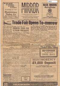
Newspaper, Diamond Valley Mirror, Diamond Valley Mirror: September 14, 1960, 14/09/1960
... East Kew ...This edition of The Diamond Valley Mirror was given to GHS as an example of local news and advertising in 1960.An example of mid-20th century newspaper4p., incomplete.newspapers, diamond valley, mirror -
 Greensborough Historical Society
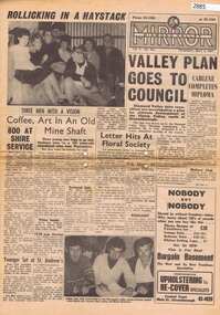
Newspaper, Elliott Provincial newspapers Pty Ltd, Diamond Valley Mirror May 4, 1965, 04/05/1965
... 1407 Burke Road , East Kew, Victoria, Australia ...Contains article "Valley plan goes to Council", discussing the development of the Plenty Valley, north of Greensborough.Early plan submitted to Diamond Valley Council in 19658 p.greensborough -
 Melbourne Tram Museum
Photograph - Set of 7 Black & White Photograph/s, Melbourne & Metropolitan Tramways Board (MMTB), 1966
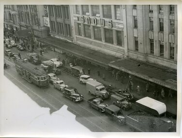
... East Kew... cart and a SW6 (East Kew) with dash canopy lighting. .6... Route 27 Route 28 East Kew Richmond Route 48 William St Safety ...Series of 7 black and white photographs of the traffic congestion in the CBD during 1951. .1 - Flinders St from Flinders St Station office looking northwest with a W2 317 Richmond route 28 and many cars. Has "32" on rear in pencil. Has Snows and the SEC building in the view. .2 - Spencer St bridge, looking north with Fish Market/Cool Stores and the VR Head Office in the view. Has Taylor and ? General Carriers and Nestle's truck in the view. .3 - William St? with passengers waiting at a safety zone - has the Dennys Lascelles building in the background. .4 - Flinders St looking north east with Snows, the SEC, a Hotel and Hearnes sign showing. Has a W2 436? route 27 Hawthorn eastbound. Typed on rear "Enlargement of No. 76, Sheet No. 28 (report P25/1/8), "Spare" written in pencil and "For Testing Engrs 1/11/51" in ink. .5 - looking north with a horse drawn cart and a SW6 (East Kew) with dash canopy lighting. .6 - looking north - with Hearnes Provisions, Olympia Inn and Coffee Lounge and Young & Jacksons Hotel. Has a W2 partly in the photo about to enter the Safety Zone. ..7 - similar to .1 - with Snows, W2 route 48 North Balwyn and a Pattons Dry Cleaning van. See also Reg 4519 for another 7 photos of the same series.trams, tramways, traffic control, congestion, flinders st, spencer st, route 27, route 28, east kew, richmond, route 48, william st, safety zone, hawthorn, tram 317, tram 436 -
 Melbourne Tram Museum
Ephemera - Timetables - MMTB Buses - set of 13, Melbourne & Metropolitan Tramways Board (MMTB), 1971 to 1973
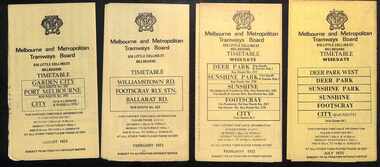
... East Kew... - routes 256, 251, 253, 254, 252 and 255 August 1972 8 - East Kew... - routes 256, 251, 253, 254, 252 and 255 August 1972 8 - East Kew ...Timetables - provide information on ticketing, fares, timing points, with a description of the route and a map. Not all services had been allocated a route number at the time. 1 - Garden City - Port Melbourne - City - routes 201, 202 - August 1972 2 - Williamstown Road - Footscray - Ballarat Rd - Route 223, Feb. 1972 3 - Deer Park, Sunshine Park, Sunshine, Footscray - City - routes 217, 219, 220, 229, 231 and 218 - Feb. 1972 4 - Deer Park West, Sunshine Park, Sunshine, Footscray - City - July 1973 5 - Fishermen's Bend - City - routes 233, 235 and 237 - March 1972 6 - Clifton Hill - Esternwick - Point Ormond - routes 246, 247 and 248 - August 1972 7 - Latrobe Uni - Northland - West Heidelberg - City - routes 256, 251, 253, 254, 252 and 255 August 1972 8 - East Kew, Box Hill, Doncaster, Shoppingtown - routes 284, 285 and 270 - July 1972 9 - Box Hill, Mitcham, East Doncaster, Ringwood - routes 287, 286, 288, 282, 283, and 272 - July 1972 10 - Box Hill - North Blackburn, route 290, printed on white paper - Sep. 1971 11 - Box Hill - Doncaster, Shoppingtown, Heidelberg, Templestowe, Serpells Rd and Lower Templestowe - routes 293, 296, 297, 271 - July 1972 12 Deer Park, Sunshine Park, Sunshine, Footscray - City - routes 217, 219, 220, 229, 231 and 218 - Saturdays and Sundays, printed on green paper - Feb. 1972 13 - Fishermans Bend - City - routes 233, 235 and 237 - June 1973 Yields information about MMTB Bus services during the 1970s. Set of twelve MMTB Bus timetables - multifolded printed on yellow paper, unless noted otherwise. timetable, mmtb, buses, port melbourne, garden city, williamstown rd, footscray, ballarat rd, sunshine, deer park, fisherman's bend, clifton hill, esternwick, point ormond, la trobe university, northland, west heidelberg, east kew, box hill, doncaster, shoppingtown, mitcham, ringwood, blackburn, templestowe, lower templestowe, fishermans bend -
 Kew Historical Society Inc
Archive (Sub-series) - Subject File, Belford Farm (Kew East), 1958
... Belford Farm (Kew East)... into the Wade family. Belford Farm (Kew East) Archive Subject File ...Various partiesReference, Research, InformationKHS OrderSubject file containing genealogical research material on the Wades of Belford Farm, all photocopied. One item was prepared for a reunion of the descendants of Peter Robert & Mary Ann Mansergh (Blair) and James & Maria Mullins (Dartnell) who arrived in the Colony on the Sailing Ship ‘China’ on 1 May 1840. The item includes lists of passenger names and the names of their descendants. The other item is an inquiry from Elvania Balcombe, which includes her own research into the Wade family.wade family - kew (vic.), farming -- kew (vic)wade family - kew (vic.), farming -- kew (vic) -
 Kew Historical Society Inc
Photograph - Former Chandler Highway Bridge, 2001
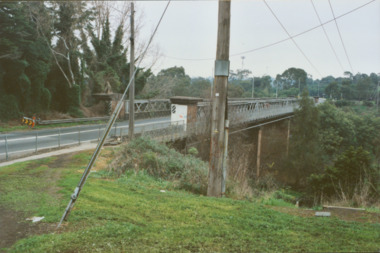
... between East Kew and Fairfield stations. In the 1930s... to bridge the Yarra River between East Kew and Fairfield stations... for the Outer Circle Railway to bridge the Yarra River between East Kew ...The heritage listed Fairfield Bridge was originally constructed for the Outer Circle Railway to bridge the Yarra River between East Kew and Fairfield stations. In the 1930s it was converted for vehicular traffic. In the 2010s a new concrete bridge was erected beside it to increase vehicular capacity. Original colour print positive of the (former) Chandler Highway bridge in 2001. The point of view is from the Fairfield side of the river looking towards Kew. The heritage listed bridge was originally constructed for the Outer Circle Railway to bridge the Yarra River between East Kew and Fairfield stations. In the 1930s it was converted for vehicular traffic. In the 2010s a new concrete bridge was erected beside it to increase vehicular capacity. Ink inscription on reverse: "Chandler Highway bridge / (Originally Outer Circle Railway Bridge) / From Fairfield side towards Kew / July 2001"bridges -- kew (vic), fairfield bridge, chandler highway bridge, outer circle railway viaduct -
 Kew Historical Society Inc
Plan - Subdivision Plan, Goldthorns Hill Estate, 1925
... Goldthorns Avenue -- Kew East (Vic.)... of the City of Melbourne. Most of these are of Kew, Kew East ...Pru Sanderson, in her groundbreaking ‘City of Kew Urban Conservation Study : Volume 2 - Development History’ (1988), summarised the periods of urban development and subdivisions of land in Kew. The periods that she identified included 1845-1880, 1880-1893, 1893-1921, 1921-1933, 1933-1943, and Post-War Development. These periods were selected as they represented periods of rapid growth or decline in urban development. An obvious starting point for Sanderson’s groupings involved population growth and the associated economic cycles. These cycles also highlighted urban expansion onto land that was predominantly rural, although in other cases it represented the decline and breakup of large estates. A number of the plans in the Kew Historical Society’s collection can also be found in other collections, such as those of the State Library of Victoria and the Boroondara Library Service. A number are however unique to the collection.The Kew Historical Society collection includes almost 100 subdivision plans pertaining to suburbs of the City of Melbourne. Most of these are of Kew, Kew East or Studley Park, although a smaller number are plans of Camberwell, Deepdene, Balwyn and Hawthorn. It is believed that the majority of the plans were gifted to the Society by persons connected with the real estate firm - J. R. Mathers and McMillan, 136 Cotham Road, Kew. The Plans in the collection are rarely in pristine form, being working plans on which the agent would write notes and record lots sold and the prices of these. The subdivision plans are historically significant examples of the growth of urban Melbourne from the beginning of the 20th Century up until the 1980s. A number of the plans are double-sided and often include a photograph on the reverse. The Goldthorns Hill Estate subdivision was first put up for auction in 1925. The subdivision took its name from the mansion ‘Goldthorns’, shown on the plan between Normanby Road and Lady Loch’s Drive. Contemporary advertisements describe forty-three home sites being fro sale, yet only forty-one appear on this plan. Buyers were lured by the prospect of the proposed extension of the Burke Road tram to High Street. Discerning buyers were advised that only one house could be built per allotment, and that houses needed to be constructed of brick, stone or concrete and have a slate or tiled roof.goldthorns avenue -- kew east (vic.), lady loch drive -- kew east (vic.), argyle road -- kew east (vic.), lady brassey drive -- kew east (vic.), campbell street -- kew east (vic.), goldthorns -- kew (vic.), subdivisions -- kew east (viv.), goldthorns hill estate -
 Robin Boyd Foundation
Book, Rodney Bennett, The Romance of Reading Book 2 - Treasure Trove, 1950
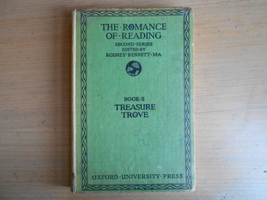
... "Mandy Boyd, 72 Riversdale Rd East Kew"... "Mandy Boyd, 72 Riversdale Rd East Kew" Hardcover, No Dust Jacket ...Hardcover, No Dust Jacket"Mandy Boyd, 72 Riversdale Rd East Kew"adult fiction short story collection, walsh st library -
Kew Historical Society Inc
Booklet - Old Kew Golf Links Estate, 1926
... Subdivisions -- Kew East (Vic)... East Primary School, the former Kew Golf Club clubhouse....) Subdivisions -- Kew East (Vic) Chipperfield's Boathouse Kew East ...Subdivision plans and real estate flyers/brochures reveal a number of aspects of urban development and history. The Kew Historical Society's collection of these plans, as well as advertisements extracted from magazines, cover key aspects of community development and architectural history of Kew and Kew Eat as well as surrounding suburbs. While most of the plans in the collection were gifted to the Society by the former City of Kew, a number of other plans and advertisements have been donated by individuals, of which this is an example.8-page brochure advertising 80 residential home sites for sale in a subdivision called the 'Old Kew Golf Links Estate'. These sites had historic importance in Kew's history as they had previously belonged to Kodak Pty Ltd who were refused permission by Kew Council to use the land for industrial development. The estate, advertised was advertised as being within five miles of Melbourne. The brochure is notable as it includes photographs of Kew East Primary School, the former Kew Golf Club clubhouse, and 'The Moorings' Boathouse (aka Chipperfield's Boat House). The aerial photograph, overlaid with names of notable sites, on the final page is of interest as it shows the area before the intrusion of the Eastern Freeway, which resulted in changing the course of a section of the Yarra River. old kew golf links estate, subdivision -- kew (vic.), subdivisions -- kew east (vic), chipperfield's boathouse, kew east primary school, kew golf club