Showing 1938 items
matching flood
-
 Orbost & District Historical Society
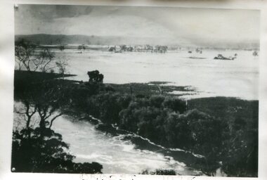
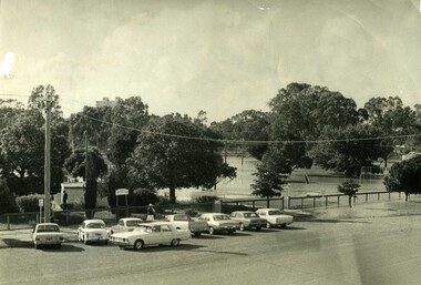
black and white photograph, February 1971
This photograph was taken near the Snowy River Bridge on the the old Princes Highway in Orbost, near the caravan park. The 1971 flood was the the worst flood on record. At Jarrahmond it was at least 11 metres and up to one and a half kilometres wide on the flats causing enormous damage to the flood plain. Records say that "The brown floodwater stain in Bass Strait could be seen from passing airliners." Considerable damage was done to railway infrastructure, roads and farms. More information from the APRIL, 2008 newsletter by John Phillips. (see orbosthistory.com.au)This is pictorial evidence of a significant local event. Floods have been an integral part of Orbost's history for hundreds of years.A black / white photograph of debris, fallen power lines, a tree across the highway and floodwaters across the road.on front at bottom - handwritten in upper case print - " 1971 FLOOD PRINCES HIGHWAY NEAR SNOWY BRIDGE"floods-orbost-1971 -
 Orbost & District Historical Society
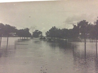
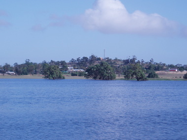
Photograph - Flood, Snowy River, Orbost 1978
The Snowy River can flood over its floodplain at Orbost/Newmerella. There have been wet periods when floods were frequent and covered the floodplain, sometimes causing great disruption to crops and farming, and also to transport. The 1970s was a wet decade with many floods, the largest one in 1971. This photograph was taken in 1978. Evidence of flood on the Snowy River in 1978. A b/w photograph of a flood scene with trees and the river in the front, a river bank, and a vast area of water in the background. This photograph has been pasted onto a rough cardboard backing. Written below the photograph: Orbost 1978floods, snowy river, orbost -
 Port Melbourne Historical & Preservation Society
Photograph - Children playing in flood waters, Ingles Street, Port Melbourne, 1940 - 1959
Small black and white photo of flood and children playing in the water. Factory CP Consolidated Pneumatic. House 39 Ingles Street 1954(?)built environment - domestic, flood, families, denise flannery o'connor, ingles street -
 Chelsea & District Historical Society Inc
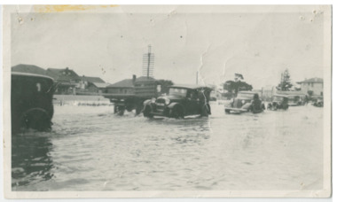
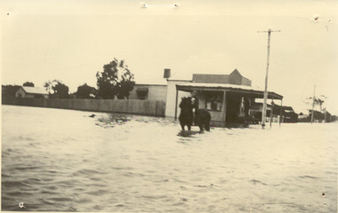
Photograph - Chelsea Flood December 1934, Point Nepean Road (Nepean Highway)
In December 1934, 700 houses were inundated with water, when the Dandenong Creek and Patterson River broke their banks.Black and white photo of flood waters across Point Nepean Road (now Nepean Highway). Cars and trucks are driving through the water.flood, chelsea, dandenong creek, nepean highway, point nepean road -
 Greensborough Historical Society
Photographs, Christmas Day 2011 Hail Storm, 25/12/2011
Christmas Day 2011 started out fine and sunny but by mid afternoon, storms - which brought with them huge hailstones, torrential rain and flash flooding swept through Melbourne suburbs. These photographs show some of the hail and flooding in the Greenhills area of Greensborough.Original photographs taken by residents of the area.21 coloured photographs, 4 black and white copies of photos (A4). Each depicts an aspect of the Christmas Day 2011 hail storm and floods in Greensborough.christmas day 2011, floods, greenhills, greensborough, hailstorms -
 Orbost & District Historical Society
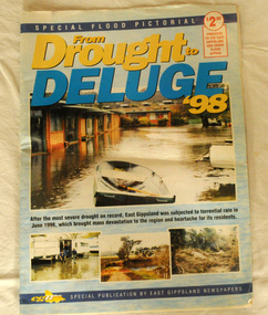
pictorial magazine, From Drought to Deluge '98, 1998
This magazine cost $2.50 and was produced to support the East Gippsland Red Cross Flood Appeal. Following heavy rain in East Gippsland in June, 1998, major flooding occurred in the Mitchell, Nicholson, Tambo, Snowy, Brodribb and Bemm Rivers. Other streams in the region also experienced high flows during this time. Probably the most severe direct impacts of the floods were to the rural sector.This magazine is a contemporary record of a significant local event.Two copies of a magazine pictorial of the floods of 1998. Photos are black and white. They are of Bairnsdale, Orbost, Lakes Entrance, Raymond Island, Bemm River, Bruthen , Tambo and Cabbage Tree. flood-1998 flood-east gippsland disaster-floods -
 Greensborough Historical Society
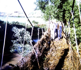
Slide - Photographic Slide, Swing bridge Greensborough, 1974
View of swing bridge Greensborough following 1974 Plenty River flood. Includes Diamond Valley Council clean-up crew of Lindsay Millington and M. SmeadKodachrome colour photographic slideHandwritten on mount: "Swing bridge Greensboroiugh; 1974 flood; L Millington; M Smead"plenty river flood, swing bridge greensborough, lindsay millington -
 Lakes Entrance Historical Society
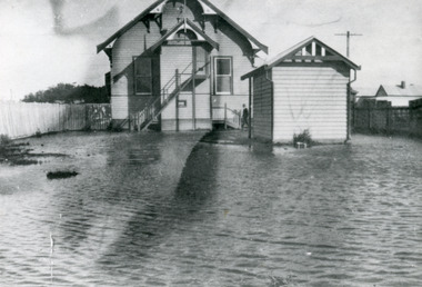
Photograph - Floods, 1934
Severe flooding all over Gippsland in August 1934. All low lying areas of Lakes Entrance flooded.Black and white photograph of flood waters around the Mechanics Hall. Shows external stairway to bio-box addition for film projector. Mr Syd Allen projectionist seen at lobby steps. Lakes Entrance VictoriaOn Back Old Cat No 77floods, halls, houses, roads and streets -
 Melbourne Tram Museum
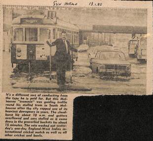
Newspaper, Herald Sun, Newspaper clipping re flooding in South Melbourne, 13-1-1980
Newspaper cutting about flooding in South Melbourne disabling a tram and a "trammie" conductor or driver, directing traffic. Tram W7 1019, route 10.Yields information about the type of delays that can occur on a big tram system.Newspaper cutting from the Herald Sun 13-1-1980 about flooding in South Melbourne and delaying tram W7 1019"Sun Herald 13.1.80"trams, tramways, tramcars, flooding, floods, south melbourne, w7 1019, route 10, crews -
 Charlton Golden Grains Museum Inc
Photograph, c.August 1909
Floods 1909, High Street, Charlton. The flooding occurred in August 1909.Black and white photo, not mounted and with no boarder.flood, charlton, business, high street -
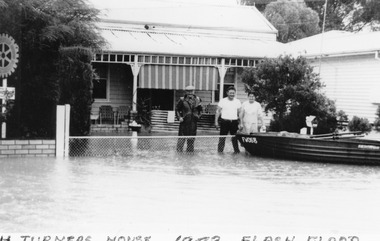 Charlton Golden Grains Museum Inc
Photograph - Photocopy
The 1973 Flood. Picture of H Turner's house in High Street with his boat tethered to the fence.Poor copy of original Photo originally used in Charlton Tribune February 23 1973 P4flood, turner -
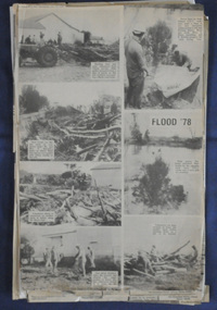 Orbost & District Historical Society
newspaper clippings, June 1978
Orbost has been subject to major floods throughout its history, such as those which left the town isolated in 1934, 1952, 1971 and 1978. It is recorded that the Snowy River broke its banks and flooded the flats 104 times between 1884 and 1978. Extensive flooding in Eastern Victoria during June 1978, caused widespread damage to roads, road closures and hazards to traffic, particularly over the Queen's Birthday holiday weekend. These newspaper articles are contemporary records of a significant event in Orbost history.A collection of black/white newspaper clippings relating to the 1978 flood in Orbost. Some are original articles. others are photo-copies. They appear to be from the Snowy River Mail newspaper.floods-orbost-1978 newspaper-articles -
Port Melbourne Historical & Preservation Society
Plan - Proposed bridge under Hobsons Bay railway at Clarendon Street, Emerald Hill, 1854 - 1884
Plan of proposed bridge under Hobson's Bay Railway at Clarendon Street, Emerald Hill, affecting Sandridge railway and Sandridge Road. Flood level re Sandridge line is shown.transport - railways, flood, emerald hill, town planning -
 Port of Echuca
A black and white postcard, 1906. or. 1916
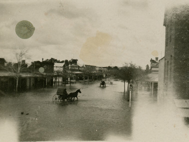
The postcard is significant because it shows the extent of the flood in the early 20th Century. The bridge crosses the Southern Cross channel which had been built as part of the Murray Darling irrigation system. There is a vehicle on the bridge either being towed by bullocks or horses. Floodwaters cover the whole view.The postcard is significant because it shows the extent of the flood in the early 20th Century. The bridge crosses the Southern Cross channel which had been built as part of the Murray Darling irrigation system. It is also near the water filtration plant which filters the town's water supply. There is a vehicle on the bridge either being towed by bullocks or horses. Floodwaters cover the whole view.A black and white postcard showing Goulburn Road, Echuca East, in either the 1906, or 1916 floods.Printed on the back are the words; W. Grimwood Echuca. POST CARD. Correspondence Address Only Kodak Australia. Hand written on the back are the words 1906 or 1916? Southern Cross bridge near filtration plant. Goulburn Road, Echuca East.floods, goulburn road, echuca east, pullicino, j, postcard, southern cross channel, water filtration plant -
 Orbost & District Historical Society
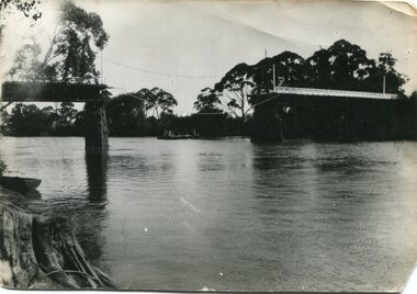
black and white photograph, January 1934
Damage estimated at £500,000 was caused by the 1934 floods in the Orbost district. This 1934 flood was devastating, destroying a section of the 1922 Orbost bridge, wrecking fences, bridges and roads, dumping silt and debris on the rich river flats and drowning cattle. The centre span of the Orbost Bridge was washed away. This item is a pictorial record of the 1934 floods, a significant part of Orbost's history.A black / white photograph showing the flood damage to the Snowy River Bridge. There is a gap in the bridge where the centre span has been washed away. In the background is a punt.orbost-floods-1934 natural-disasters-floods snowy-river-bridge -
 Wycheproof & District Historical Society Inc.
Photograph, Len Storey, Cooroopajerrup Creek 2011, 17/1/2011 (exact)
On Monday January 17th 2011,Wycheproof residents awoke to see the township surrounded by water. Record flooding on the Avoca River had forced the flood water up the semi-mythical Cooroopajerrup Creek. Digital colour photograph of the Cooroorajerrup Creek, depicting the flood-waters of 2011 surrounding Mount Wycheproof. The dwelling in the foreground is the home of Francis and Denise Dillon, barely visible to the left is the Public Hospital.cooroopajerrup creek, mount wycheproof, 2011, flood waters -
 Chelsea & District Historical Society Inc
Photograph - Chelsea Flood December 1934, Corner of Sherwood Avenue and Fowler Street
In December 1934, 700 houses were inundated with water, when the Dandenong Creek and Patterson River broke their banks.Black and white photo of water inundating a shop on the corner of Sherwood Avenue and Fowler Street, Chelsea. A person is on course back riding through the flood waters.flood, chelsea, dandenong creek, fowler street, sherwood avenue -
 Hume City Civic Collection
Photograph
The series of photographs were taken after exceptional heavy rain had fallen in Sunbury in the early 1990s. Jackson's Creek overflowed its banks and the surrounding flood plain area was under water.A coloured photograph of Jackson's Creek in flood taken near the footbridge in Macedon Street. The Nook area and Goonawarra Vineyard are in the background.floods, weather patterns, jacksons creek, george evans collection -
 Hume City Civic Collection
Photograph
The series of photographs were taken after exceptional heavy rain had fallen in Sunbury in the early 1990s. Jackson's Creek overflowed its banks and the surrounding flood plain area was under water.A coloured photograph of Jackson's Creek in flood. The floodwaters have almost reached the top of the arch of the Macedon Street stone bridge.floods, weather patterns, jacksons creek, george evans collection -
 Clunes Museum
Photograph, FLOODS 1934
AFTER HEAVY RAINS - CRESWICK CREEK IN CLUNES TOWNSHIP FLOODED, OVER FLOWING ITS BANKS, NEAR BY AREAS WERE SUBMERGED.BLACK AND WHITE SMALL PHOTOGRAPH OF CLUNES FLOODS IN 1934. CLUNES QUEEN'S PARK WITH FOUNTAIN UNDER WATER - TREES IN THE BACKGROUND AND A FEW FLOWERS IN THE FOREGROUND.local history, queen's park garden., floods 1934 -
 Victorian Interpretive Projects Inc.
Photograph - Colour, Clare Gervasoni, Rain Inundation on the corner of Armstrong Street (south) and Eyre Streets, Ballarat, 2011, 22/10/2011
The flooded area is on the part of Ballarat known as the escarpmentrain, ballarat, flood -
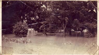
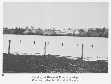 Eltham District Historical Society Inc
Work on paper (Sub-Item) - Photograph, Flooding at Diamond Creek Township
Black and white photograph of the Diamond Creek in flood at Diamond Creek township in 1934. In 1934 extensive flooding of the Yarra River and Diamond Creek set new records for flood plain level (Eltham Chronology EDHS) Nillumbik Historical Society collectionflood, diamond creek, flooding, nillumbik historical society -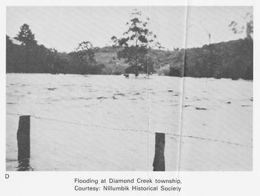
 Kew Historical Society Inc
Photograph - Flooding of the Yarra Valley at Kew East, 1974
Flooding of the Yarra Valley, including that section of the Yarra bordering Kew and Kew East in the north and west of the municipality, was a regular occurrence. Extreme flood events of the Yarra River are recorded to have occurred in 1891, 1901, 1916, 1923 and 1934. The Municipality of Kew's response to these floods was to enact planning decisions restricting residential development in flood prone areas following the floods of 1916, 1921 and 1934. While floods continued after the development of the Upper Yarra Reservoir (construction 1948-57), the regularity and extent of these inundations diminished. During the nineteenth century, the land abutting the south side of the Yarra in Kew was devoted to dairy farming. In the twentieth century, before and after the construction of the Eastern Freeway, much of this low-lying area was used as golf courses and public parks.Late example of the capacity of the Yarra Valley at Kew to flood, even though drainage works and the Upper Yarra Reservoir had reduced their regularity.Original black and white print photograph of Hay's Paddock under floodwater on 16 May 1974. The vantage point of the photographer is Keystone Crescent looking east. Flooding was caused by overflowing water in Glass' Creek and the River Yarra. Annotation verso: "Keystone Cr looking east / 16 May 1974 11.50am"hays paddock, floods, yarra river, glass' creek -
 Charlton Golden Grains Museum Inc
Photograph, Cameron, Ian, 01/02/1973
Taken by the editor of The Charlton Tribune Ian Cameron. Of the 1973 flood at Gordon Park and Croquet Club. Highest flood since 1956, 25 feet 1 1/2 at the bridge, 4 inches of rain fell in the catchment. Road damage after the flood was estimated to be $74,800.Large sepia photograph unframed, creased in top RH corner, surface torn on left edge. Unmountedflood, gordon park, croquet club, charlton -
 Kew Historical Society Inc
Photograph - Flooding of the Yarra Valley at Kew East, 1974
Flooding of the Yarra Valley, including that section of the Yarra bordering Kew and Kew East in the north and west of the municipality, was a regular occurrence. Extreme flood events of the Yarra River are recorded to have occurred in 1891, 1901, 1916, 1923 and 1934. The Municipality of Kew's response to these floods was to enact planning decisions restricting residential development in flood prone areas following the floods of 1916, 1921 and 1934. While floods continued after the development of the Upper Yarra Reservoir (construction 1948-57), the regularity and extent of these inundations diminished. During the nineteenth century, the land abutting the south side of the Yarra in Kew was devoted to dairy farming. In the twentieth century, before and after the construction of the Eastern Freeway, much of this low-lying area was used as golf courses and public parks.Late example of the capacity of the Yarra Valley at Kew to flood, even though drainage works and the Upper Yarra Reservoir had reduced their regularity.Original black and white print photograph of the low-lying land at East Kew under floodwater on 16 May 1974. The vantage point of the photographer is Lister Street. Flooding was caused by overflowing water in Glass' Creek and the River Yarra. Annotation verso: "Lister St looking same as No.3 / 16 May 1974 11.30"floods, yarra river, glass' creek, lister street -
 Orbost & District Historical Society
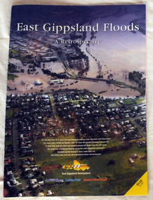
pictorial magazine, East Gippsland Floods A Retrospective, 2007
This magazine pictorial was produced by East Gippsland News as a record of the Floods of June/July 2007.This is a contemporary record of a local event.A magazine pictorial with photos of the June/July East Gippsland flood event in 2007. Photos are of Bairnsdale, Lakes Entrance, Lake Tyers, Orbost, Linenow, Metung, Eagle Point and Paynesville.floods-east gippsland disasters-flood -
 Charlton Golden Grains Museum Inc
Photograph, Charlton Tribune, B/W Photograph of 1973 Flooded Avoca River, February 1973
1973 Flooded Avoca River in Charlton Victoria at the Paterson Bridge. Water Level 25ft 1 1/2 inches - all local waterunframed 1973 Flooded Avoca River in Charlton Victoria at the Paterson Bridge. Water Level 25ft 1 1/2 inches - all local waterflood charlton victoria, james paterson bridge, local water -
 National Wool Museum
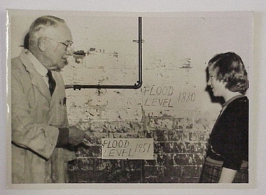
Photograph
Photograph, of two people looking at the flood levels 1880 and 1951, marked on a wall. The photograph is possibly of the Godfrey Hirst and Co Pty Ltd mill c1951Photograph, of two people looking at the flood levels 1880 and 1951, marked on a wall. The photograph is possibly of the Godfrey Hirst and Co Pty Ltd mill c1951.W C Meyer Photographer/ 233 Myers Street/ East Geelong. Phone 3289textile mills - history textile mills - staff, godfrey hirst and co. pty ltd excelsior woollen and worsted mills, textile mills - history, textile mills - staff -
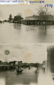 Charlton Golden Grains Museum Inc
Photograph, August c.1909
1909 Flood - Cricket Club cnr and High Street. The flood occurred in August of 1909 Black and White double photo. The top half shows the Cricket Hotel the bottom half shows a view down High Street Charltoncricket cub hotel, 1909 flood, flood, charlton, business