Showing 375 items
matching horse trainer
-
 Victorian Harness Racing Heritage Collection at Lord's Raceway Bendigo
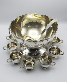
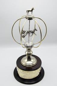
Memorabilia - Silver trophy, Adelaide Direct, 1917 New Zealand Cup
Adelaide Direct (10 yo mare at the time) won the 1917 New Zealand Trotting Cup over 2 miles starting from a 7 second handicap. She ran a New Zealand race winning record time of 4 minutes 27.8 seconds. She defeated Cathedral Chimes 2nd by 4 lengths with Author Dillon 3rd. She was Owned/Leased, Trained and Driven by Manny Edwards.Two Handled Cup shaped Trophy with a LidNew Zealand Metropolitan Trotting Club / Presented by / Mr Chas Louisson / President / to / M Edwards / Owner of "Adelaide Direct" Time 4 min 27 4/5 sec / Winner of N.Z. Cup Race NovR 1917trophy, harness horse, new zealand metropolitan trotting club, adelaide direct, 1917, new zealand cup, nz cup, mr chas louisson, manny edwards -
 Victorian Harness Racing Heritage Collection at Lord's Raceway Bendigo
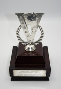
Memorabilia - Gold, Silver trophy, Mother Courage, 1999 Australian Oaks
Mother Courage (Stoneridge Scooter Imp P 1.50.8 - Talk To Me Vic P 1.59.6 (What's Next)) Bay Mare. Foaled 1995 (3rd Foal) Breeder/Owner: Castle Family Pty Ltd. Trainer B Morgan. Mother Courage raced from 1998 (2yo) through to 2003 (7yo). Career: 30 wins 19 seconds 9 thirds 81 starts $462,520 1.56.9 Winning Drivers: JJ Caldow (27) BR Gath (3). Won on 8 Tracks: Moonee Valley (14) Ballarat (6) Bendigo (2) Horsham (2) Maryborough (2) Kilmore (2) Hamilton (1) Mildura (1)Mother Courage won the 1999 Australian Oaks at Moonee Valley over 2060m at a mile rate of 1.58.6. Driven by JJ Caldow. Defeating Frosty Lady 2nd and Ok Rock NZ 3rd.Punch Bowl Set TrophyAustralian Oaks / Moonee Valley / Saturday 7 August 1999 / "Mother Courage"trophy, harness horse, mother courage, australian oaks, 1999, moonee valley, jj caldow, john caldow, bruce morgan, b morgan -
 Victorian Harness Racing Heritage Collection at Lord's Raceway Bendigo
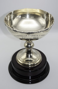
Memorabilia - Silver trophy, Mother Courage, 1999 Victoria Oaks
Mother Courage (Stoneridge Scooter Imp P 1.50.8 - Talk To Me Vic P 1.59.6 (What's Next)) Bay Mare. Foaled 1995 (3rd Foal) Breeder/Owner: Castle Family Pty Ltd. Trainer B Morgan. Mother Courage raced from 1988 (2yo) through to 2003 (7yo). Career: 30 wins 19 seconds 9 thirds 81 starts $462,520 1.56.9 Winning Drivers: JJ Caldow (27) BR Gath (3). Won on 8 Tracks: Moonee Valley (14) Ballarat (6) Bendigo (2) Horsham (2) Maryborough (2) Kilmore (2) Hamilton (1) Mildura (1) Mother Courage won the 1999 Victoria Oaks at Ballarat over 2170m at a mile rate of 1.58.7. Driven by JJ Caldow. Defeating Lombo Rapida 2nd and Jilliby Magic 3rd. Cup Shaped Trophy on a Wooden BaseCampbells Cash & Carry / Victoria Oaks / Ballarat / Saturday 1 May 1999 / Won by "Mother Courage"trophy, harness horse, mother courage, 1999, victoria oaks, ballarat, jj caldow, john caldow, bruce morgan, b morgan -
 Victorian Harness Racing Heritage Collection at Lord's Raceway Bendigo
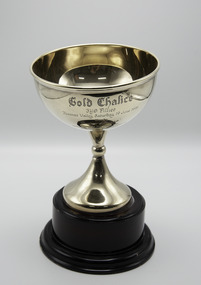
Memorabilia - Gold trophy, Mother Courage, 1999 Gold Chalice 3yo Fillies
Mother Courage (Stoneridge Scooter Imp P 1.50.8 - Talk To Me Vic P 1.59.6 (What's Next)) Bay Mare. Foaled 1995 (3rd Foal) Breeder/Owner: Castle Family Pty Ltd. Trainer B Morgan. Mother Courage raced from 1998 (2yo) through to 2003 (7yo). Career: 30 wins 19 seconds 9 thirds 81 starts $462,520 1.56.9 Winning Drivers: JJ Caldow (27) BR Gath (3). Won on 8 Tracks: Moonee Valley (14) Ballarat (6) Bendigo (2) Horsham (2) Maryborough (2) Kilmore (2) Hamilton (1) Mildura (1)Mother Courage won the 1999 Gold Chalice 3yo Fillies race at Moonee Valley over 2060m at a mile rate of 2.04.5. Driven by JJ Caldow. Defeating Jilliby Magic 2nd and Dame Rainbow 3rd.Cup Shaped Trophy on a Wooden BaseGold Chalice / 3yo Fillies / Moonee Valley Saturday 19 June 1999 / Won by / "Mother Courage" / Proudly donated by the / Victorian Standardbred Breeders & / Studmasters Associationtrophy, harness horse, mother courage, 1999, moonee valley, gold chalice, 3yo fillies, victorian standardbred breeders & studmasters association, jj caldow, john caldow, bruce morgan, b morgan -
 Victorian Harness Racing Heritage Collection at Lord's Raceway Bendigo
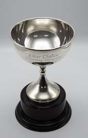
Memorabilia - Silver trophy, Mother Courage, 2000 Silver Chalice
Mother Courage (Stoneridge Scooter Imp P 1.50.8 - Talk To Me Vic P 1.59.6 (What's Next)) Bay Mare. Foaled 1995 (3rd Foal) Breeder/Owner: Castle Family Pty Ltd. Trainer B Morgan. Mother Courage raced from 1998 (2yo) through to 2003 (7yo). Career: 30 wins 19 seconds 9 thirds 81 starts $462,520 1.56.9 Winning Drivers: JJ Caldow (27) BR Gath (3). Won on 8 Tracks: Moonee Valley (14) Ballarat (6) Bendigo (2) Horsham (2) Maryborough (2) Kilmore(2) Hamilton (1) Mildura (1)Mother Courage won the 2000 Silver Chalice at Moonee Valley over 2060m at a mile rate of 1.59.1. Driven by JJ Caldow. Defeating Lombo Rapida 2nd and Jilliby Magic 3rd.Cup Shaped Trophy on a Wooden BaseSilver Chalice / Moonee Valley 4 March 2000 / Won by / "Mother Courage" / Proudly donated by the / Victorian Standardbred Breeders & Studmasters Associationtrophy, harness horse, mother courage, moonee valley, victorian standardbred breeders & studmasters association, 2000, silver chalice, jj caldow, john caldow, bruce morgan, b morgan -
 Victorian Harness Racing Heritage Collection at Lord's Raceway Bendigo
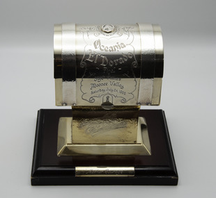
Memorabilia - Silver trophy, Mother Courage, 1999 Oceania El Dorado 3yo Fillies Final
Mother Courage (Stoneridge Scooter Imp P 1.50.8 - Talk To Me Vic P 1.59.6 (What's Next)) Bay Mare. Foaled 1995 (3rd Foal) Breeder/Owner: Castle Family Pty Ltd. Trainer B Morgan. Mother Courage raced from 1998 (2yo) through to 2003 (7yo). Career: 30 wins 19 seconds 9 thirds 81 starts $462,520 1.56.9 Winning Drivers: JJ Caldow (27) BR Gath (3). Won on 8 Tracks: Moonee Valley (14) Ballarat (6) Bendigo (2) Horsham (2) Maryborough (2) Kilmore (2) Hamilton (1) Mildura (1)Mother Courage won the 1999 Oceania El Dorado 3yo Fillies Final at Moonee Valley over 2060m at a mile rate of 2.00.1. Driven by JJ Caldow. Defeating Surstromming 2nd and Pumpkin 3rd.Chest Shaped Trophy on a Wooden BaseOn Chest: Oceania El Dorado Final 3yo Fillies / Moonee Valley / Saturday 24, 1999 On Stand: El Dorado On Base: Mother Courage trophy, harness horse, mother courage, moonee valley, 1999, oceania el dorado, jj caldow, john caldow, bruce morgan, b morgan -
 Victorian Harness Racing Heritage Collection at Lord's Raceway Bendigo
Memorabilia - Glass trophy, Mother Courage, 1999 SB&SA Award
Mother Courage (Stoneridge Scooter Imp P 1.50.8 - Talk To Me Vic P 1.59.6 (What's Next)) Bay Mare. Foaled 1995 (3rd Foal) Breeder/Owner: Castle Family Pty Ltd. Trainer: B Morgan. Mother Courage raced from 1998 (2yo) through to 2003 (7yo). Career: 30 wins 19 seconds 9 thirds 81 starts $462,520 1.56.9 Winning Drivers: JJ Caldow (27) BR Gath (3). Won on 8 Tracks: Moonee Valley (14) Ballarat (6) Bendigo (2) Horsham (2) Maryborough (2) Kilmore (2) Hamilton (1) Mildura (1)1999 SB&SA Award won by Mother Courage and Breeder: Castle Family Pty Ltd Silver V Shaped Trophy on a Wooden Base"Mother Courage" / 1999 Australian Oaks G.1 / 1999 Victoria Oaks G.1 / Breeder: Castle Family Pty Ltd trophy, harness horse, mother courage, 1999, sb&sa, castle family pty ltd, jj caldow, john caldow, bruce morgan, b morgan -
 Victorian Harness Racing Heritage Collection at Lord's Raceway Bendigo
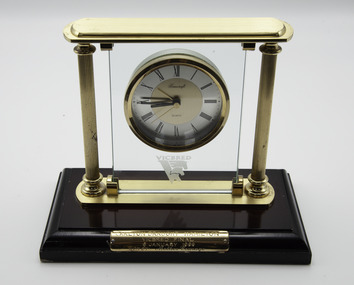
Memorabilia - Glass trophy, Mother Courage, 1999 Hamilton Vicbred Final
Mother Courage (Stoneridge Scooter Imp P 1.50.8 - Talk To Me Vic P 1.59.6 (What's Next)) Bay Mare. Foaled 1995 (3rd Foal) Breeder/Owner: Castle Family Pty Ltd. Trainer B Morgan. Mother Courage raced from 1998 (2yo) through to 2003 (7yo). Career: 30 wins 19 seconds 9 thirds 81 starts $462,520 1.56.9 Winning Drivers: JJ Caldow (27) BR Gath (3). Won on 8 Tracks: Moonee Valley (14) Ballarat (6) Bendigo (2) Horsham (2) Maryborough (2) Kilmore (2) Hamilton (1) Mildura (1) Mother Courage won the 1999 Hamilton Vicbred Final (Won Heat at Horsham) at Hamilton over 2150m at a mile rate of 2.00.2. Driven by JJ Caldow. Defeating Childers Next 2nd and Magic Maiden 3rd. Glass Clock Trophy on a Wooden BaseVicbred / Carlton Draught Hamilton / Vicbred Final / 6 January 1999 / Won by Mother Courage trophy, harness horse, mother courage, 1999, vicbred, carlton draught hamilton, jj caldow, john caldow, bruce morgan, b morgan -
 Victorian Harness Racing Heritage Collection at Lord's Raceway Bendigo
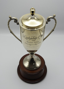
Memorabilia - Gold trophy, Mother Courage, 2002 Ladyship Cup
Mother Courage (Stoneridge Scooter Imp P 1.50.8 - Talk To Me Vic P 1.59.6 (What's Next )) Bay Mare. Foaled 1995 (3rd Foal) Breeder/Owner: Castle Family Pty Ltd. Trainer B Morgan. Mother Courage raced from 1998 (2yo) through to 2003 (7yo). Career: 30 wins 19 seconds 9 thirds 81 starts $462,520 1.56.9 Winning Drivers: JJ Caldow (27) BR Gath (3). Won on 8 Tracks: Moonee Valley (14) Ballarat (6) Bendigo (2) Horsham (2) Maryborough (2) Kilmore (2) Hamilton (1) Mildura (1)Mother Courage won the 2002 Ladyship Cup at Moonee Valley over 1609m at a mile rate of 1.56.9. Driven by JJ Caldow. Defeating Candyrama 2nd and Her Sparky Self 3rd. Two Handled Cup Shaped Trophy with Lid on a Wooden BaseLadyship Cup / Moonee Valley / Saturday 4 May 2002 / Mother Courage trophy, harness horse, mother courage, 2002, ladyship cup, moonee valley, jj caldow, john caldow, bruce morgan, b morgan -
 Victorian Harness Racing Heritage Collection at Lord's Raceway Bendigo
Memorabilia - Gold trophy, Mother Courage, 2002 Bendigo Pacing Cup
Mother Courage (Stoneridge Scooter Imp P 1.50.8 - Talk To Me Vic P 1.59.6 (What's Next)) Bay Mare. Foaled 1995 (3rd Foal) Breeder/Owner: Castle Family Pty Ltd. Trainer B Morgan. Mother Courage raced from 1998 (2yo) through to 2003 (7yo). Career: 30 wins 19 seconds 9 thirds 81 starts $462,520 1.56.9 Winning Drivers: JJ Caldow (27) BR Gath (3). Won on 8 Tracks: Moonee Valley (14) Ballarat (6) Bendigo (2) Horsham (2) Maryborough (2) Kilmore (2) Hamilton (1) Mildura (1)Mother Courage won the 2002 Bendigo Pacing Cup at Bendigo over 2415m at a mile rate of 1.59.4. Driven by JJ Caldow. Defeating Wally Walton 2nd and All For One 3rd. Two Handled Cup Shaped Trophy on a Wooden Base2002 / Moama Bowling Club / Bendigo / Pacing Cup / Saturday 23 March 2002 / Won by Mother Courage trophy, harness horse, mother courage, 2002, bendigo, pacing cup, jj caldow, john caldow, bruce morgan -
 Victorian Harness Racing Heritage Collection at Lord's Raceway Bendigo
Memorabilia - Gold, Silver trophy, Mother Courage, 1998 Vicbred Super Series 2yo Fillies Final
Mother Courage (Stoneridge Scooter Imp P 1.50.8 - Talk To Me Vic P1.59.6 (What's Next)) Bay Mare. Foaled 1995 (3rd Foal) Breeder/Owner: Castle Family Pty Ltd. Trainer B Morgan. Mother Courage raced from 1998 (2yo) through to 2003 (7yo). Career: 30 wins 19 seconds 9 thirds 81 starts $462,520 1.56.9 Winning Drivers: JJ Caldow (27) BR Gath (3). Won on 8 tracks: Moonee Valley (14) Ballarat (6) Bendigo (2) Horsham (2) Maryborough (2) Kilmore (2) Hamilton (1) Mildura (1)Mother Courage won the 1998 Vicbred Super Series 2yo Fillies Final (Group 2) at Moonee Valley over 1940m at a mile rate of 2.04.9. Driven by BR Gath. Defeating Lombo Adreamin 2nd and Skips Daughter 3rd. Gold and Silver Trophy on a Wooden BaseVicbred / Super Series / Final / 2yo Fillies / Moonee Valley / Saturday 8 August 1998 / Won by Mother Courage trophy, harness horse, mother courage, 1998, vicbred super series, moonee valley, 2yo fillies, jj caldow, john caldow, bruce morgan, br gath, brian gath, b gath -
 Victorian Harness Racing Heritage Collection at Lord's Raceway Bendigo
Clothing - Race colours, Jack Hargreaves, 13/8/21
... , Hughie, was a successful driver and trainer who raced horses all..., Hughie, was a successful driver and trainer who raced horses all ...Jack Hargreaves drove Adaptor to win the 1969 Bendigo Cup. Jack Hargreaves, who died on December 6 at the Bendigo Hospital aged 77, trained and drove countless winners during a 34-year harness racing career in which he became one of the true icons of the sport. Born John Henry Hargreaves in Wedderburn on December 3, 1926, harness racing was always in his blood. His father, Hughie, was a successful driver and trainer who raced horses all over Victoria. Jack drove his first winner at the age of 16 at Woodend. He lived on the family farm at Kuracca, near Wedderburn, until the age of 22, when he then married Elvie Stephenson from Fentons Creek. He and Elvie went on to have four children - Helen (now 53), Judi (51), Roslyn (49) and John (45). They are grandparents of 15 and great-grandparents of two. After spending two years at Tallarook where he worked on a sheep property, Jack and Elvie then moved to Korong Vale, where Jack set up his own training stable. He kept about 20 horses at a time at his Korong Vale stable, training and racing all of them for 26 years at his property. His greatest moment was the 1969 Miracle Mile, when he drove Adaptor to victory. Adaptor would later be sold to America for the then highest figure paid for an export horse - about $250,000. He also notched up many wins in country pacing cups, including Bendigo, Geelong, Maryborough, Kilmore and St Arnaud. During his career, Jack built a reputation of being a fine judge of pace and he consistently brought out the best in some difficult horses. His natural ability led to him being crowned Bendigo's leading driver for the season on two occasions. But an accident at Mildura on November 26, 1976 - just days before his 50th birthday - led to his driving career being cut short prematurely. Jack sustained head injuries after he was trampled by another horse after being tipped out of his sulky while driving Go Ned. He was regaining his senses and sitting up in the middle of the track when the horse went straight over him. The hoof of the horse came down between his left ear and skullcap, shattering that part of his skull. In the weeks following the accident, Jack underwent lengthy operations in Melbourne, to firstly clear splinters of bone from his brain. He then had a piece of bone removed from one of his ribs to cover a hole in his skull. He was left with injuries that were described as being similar to those of a person who had suffered a stroke. Months of physiotherapy and speech therapy followed in Melbourne and later Bendigo, before he was finally allowed to go hone in August, 1977 - almost one year after the accident. After losing part of his speech in the accident, Jack learned to communicate using his hands. "It became second-nature to us that we could read his hand signals and most of the people in the harness racing world could, too," Jack's daughter, Judi Bond, said."He learned his own way to communicate with people."While Jack was no longer able to continue his passion of driving competitively, he would still take the reins at the training track when given a chance to by his fellow drivers.He also continued to breed horses. "He was a skilled horseman, a good farrier and horses were the love of his life," Judi said. Two years after the accident, Jack and Elvie built a house in Wedderburn, directly above the trotting track. "That was so in the early days after his accident he could still see what was going on at the track," Judi said. "Everyday, he would watch the trainers . . . he'd watch what they were up to on the track."Jack was able to sit in his loungeroom and look out through large glass doors with a "grandstand" view of Leg 5 races, trials and training at the trotting track. Jack's love of harness racing filtered through to his children, with both Judi and John having careers as drivers. Judi drove for 10 years, finishing in 1978, but she continues to breed horses. Judi won the first women's race where bets were allowed to be made when she drove Youdini to victory at the Melbourne Showgrounds track in 1974.Blue with yellow vertical panelbendigo cup, adaptor, horse, jack hargreaves, bhrc, bendigo harness racing club, lords raceway, j hargreaves -
 Victorian Harness Racing Heritage Collection at Lord's Raceway Bendigo
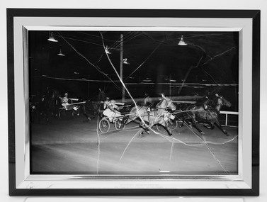
Photograph - Framed photo finish, Kalama's Peak, 17 December 1965
Photo Finish shows Kalama's Peak winning the Penrith Handicap (2.19 or better) at Harold Park NSW on 17 December 1965 defeating Smart Set (2nd) and Tradran (3rd). Driven by Merv Adams. Distance 13 furlongs 98 yards. Started from a 24 yard handicap. Mile Rate 2.10.0. Kalama's Peak won the Bendigo Pacing Cup on the 8 March 1965 defeating Future Raider (2nd) and Chief Cloud (3rd). Driven by JP Moore. Kalama's Peak was owned by RJ Webster, was trained and driven in Australia by JP Moore, K Raw and M Adams. Kalama's Peak raced from 1962 (2YO) through to 1966 then raced in US from 1966 until 1968 (8YO). Career: 23 wins 8 seconds 6 thirds 88 starts.One large black and white photo in a black and white frame. Nilbendigo harness racing club, horses, race, winner, bendigo trotting club, pacing cup, driver, trainer, owner, kalama's peak, rj webster, m adams, jp moore, harold park, keith raw, jack moore, merv adams, ke raw, k raw, j moore -
 Victorian Harness Racing Heritage Collection at Lord's Raceway Bendigo
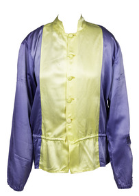
Clothing - Race colours, Don Dove
DON DOVE – 2016 Victorian Harness Racing Hall of Fame inductee A highly successful trainer-driver, Don Dove had something that most colleagues never had – his own sire. After making his mark early on as a driver, Don began training and driving the progeny of Dignus, a grand-son of Light Brigade he had purchased. Many of its 57 winners he trained and drove himself. The most memorable of these of course was his best-ever pacer, a 1966 colt he named Monara. It won successive A. G. Hunter Cups in 1973 and 74, and many other races – so often with this brilliant beginner going to the lead and then Don playing cat-and-mouse tactics out in front before dashing this son of Dignus away and holding off all comers. Those who may remember the 1972 Inter Dominion Final when Don was having a little holiday, will agree Monara was something beaten into second place that night. Don won many races on his brother Eric’s trotter Just Money, along with Nelson’s Report, Lauries Legacy and Kara Miss, and filled in well when winning the 1965 Warragul Cup driving the great little Macaree, and the 1967 Victoria Derby driving Kelly Kid. When the Victorian Trainers and Drivers Association formed in 1968, he was elected to its first committee. Don is also the father of Trevor and Stephen, both well known horsemen of a few seasons back. In retirement, Don Dove moved to Queensland in 1998 and it was there he passed away in 2014 at the age of 86.Yellow, with green crossed sashesdon dove, d dove, monara, amlin, bendigo harness racing club, bhrc, bendigo, horses, race colours, trotting, pacing, harness racing, dv dove -
 Victorian Harness Racing Heritage Collection at Lord's Raceway Bendigo
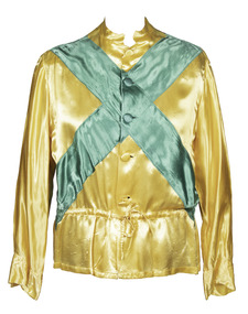
Clothing - Race Colours, Charlie Robertson
Charlie Robertson Jnr. Charlie Robertson, a Boort district farmer and trainer-driver, won his first race driving a horse called Black Spot in 1912 when he was 16. He drove many winners in the 1920s and 1930s, some of them trained by his father Charles Snr who had raced horses from the 1890s. He had a top trotter in Fair Admiral, who won the 1929 Victoria Trotters Derby among other races. As his career flourished, Charlie Jnr won with such horses as Lee Voyage, Royal Bronte, Johnnie Bronte, Betty Direct, Bonnie Heather and Leading Style. He was given the Globe Derby stallion New Derby to train by owner Jack King of Quambatook. He travelled to Tasmania and Western Australia with New Derby. In Tasmania in 1935, New Derby won the Hobart and Launceston Cups and in WA in 1936 won two heats of the inaugural Inter Dominion. Among New Derby’s wins were the 1932 and 1933 Ascot £500. He left 147 winners when standing at stud at Quambatook. During World War II one of the few venues for harness racing was Wayville in Adelaide. During this period Charlie made many trips across the border to race. On the commencement of night trotting, Robertson won many at the Royal Melbourne Showgrounds with Something New, Village Derby and Midnight News, New Gold, Canargo and Tennessee Derby. A bad race smash on Tennessee Derby nearly ended Charlie’s life, but he recovered. In the 1960s Charlie stood the stallion Convivial, who provided him with many winners. He retired from race driving aged 68 and died aged 87 after more than 60 years in trotting.Yellow with cream starscharlie robertson, c robertson, charlie robertson jnr, c robertson jnr -
 Victorian Harness Racing Heritage Collection at Lord's Raceway Bendigo
Photograph - Hand coloured portrait, New Derby
Large hand colour photograph depicting a driver on his sulky and horse.New Derby / Globe Derby New - Zealand Greta / Owner L. King - Trainer and Driver C. Robertson Jnr / Winner of Ascot £500 Trot 1932trotting, new derby, boort, jack king, globe derby, new zealand greta, ascot, 1932, charlie robertson jnr, c robertson jnr, charlie robertson, c robertson -
 Victorian Harness Racing Heritage Collection at Lord's Raceway Bendigo
Photograph - Portrait, horse and jockey, George Daniel, Val Rosa, Pacer
From the collection of Morris Hesse, grandson of trainer/rider George DanielWon 1932 Bendigo Jockey Club Open, 1923 Boort CupLarge Silver framed photo of George Daniel riding the pacer Val RosaVal Rosa, George Daniel. Val Rosa by Le Rosier NZ from Mimbric Queentrotting, george daniel, val rosa, bendigo trotting, g daniel -
 Victorian Harness Racing Heritage Collection at Lord's Raceway Bendigo
Clothing - Race colours, Jim O'Sullivan, 2017
Bendigo Pacing Cup, 1988, Jim OSullivan, Driver, TrainerPink, dark blue V, Green sleevesjim o'sullivan, j o'sullivan, quite famous, margaret shannon, bendigo harness racing club, bhrc, bendigo, horses, race colours, trotting, pacing, harness racing -
 Victorian Harness Racing Heritage Collection at Lord's Raceway Bendigo
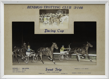
Photograph - Framed photo finish, Greg Matthews Photo, Sweet Trip, 11 January 1966
Sweet Trip won the Bendigo Pacing Cup on the 11 January 1966, followed by Fosmar and Macaree. Sweet Trip owned by I & K McLean, was trained and driven by BK Coram. Sweet Trip raced from 1963 (3YO) through to 1967 then raced in US from 1968 until 1969 (9YO). Career: 18 wins 34 seconds 19 thirds 140 starts.Two colour photographs, one small one large in a white frame. At the top: Bendigo Trotting Club 11-1-66/ Pacing Cup At the bottom: Left corner: Distance 2600 metres/ Mile rate 2.7-1/5 / Greg Matthews Photo Centre: Sweet Trip (Ribands - Graceful Spring) / Fosmar 2nd / Macaree 3rd Right corner: Owned by- I & K McLean/ Trained and driven by - BK Corambendigo harness racing club, horses, race, winner, bendigo trotting club, pacing cup, driver, trainer, owner, sweet trip, bk coram, i & k mclean, 1966, fosmar, macaree, bruce coram -
 Victorian Harness Racing Heritage Collection at Lord's Raceway Bendigo
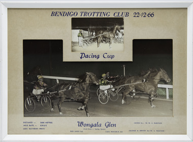
Photograph - Framed photo finish, Greg Matthews Photo, Wongala Glen, 22 December 1966
Wongala Glen won the Bendigo Pacing Cup on the 22 December 1966, followed by Bon Adios and Tara Monarch. Wongala Glen owned by Mr WA McKenzie, was trained and driven by WA McKenzie. Two colour photographs, one small one large in a white frame. At the top: Bendigo Trotting Club 22-12-66/ Pacing Cup At the bottom: Left corner: Distance 2600 metres/ Mile rate 2.9-2/5 / Greg Matthews Photo Centre: Wongala Glen (Lord Kara - Spring Queen) / Bon Adios 2nd / Tara Monarch 3rd Right corner: Owned by- Mr WA McKenzie/ Trained and driven by - WA McKenziebendigo harness racing club, horses, race, winner, bendigo trotting club, pacing cup, driver, trainer, owner, 1966, wongala glen, wa mckenzie, bon adios, tara monarch, bill mckenzie -
 Victorian Harness Racing Heritage Collection at Lord's Raceway Bendigo
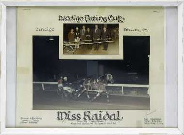
Photograph - Framed photo finish, Miss Raidal, 5 January 1971
Miss Raidal won the Bendigo Pacing Cup on the 5 January 1971, followed by Allegiance Choice and Gallymont Road. Miss Raidal owned by A & M Perry, was trained by A Perry, driven by B Morse. Miss Raidal raced from 1969 (3yo) through to 1974 (8yo). Career: 15 wins 11 seconds 8 thirds 123 starts.Two colour photographs, one small one large in a white frame. At the top: Bendigo Pacing Club Bendigo 5th Jan 1971 At the bottom: Left corner: Owner A & M Perry/ Trainer A Perry/ Driver B Morse Centre: Miss Raidal (Alcoran - Cissy Raider) / Allegiance Choice 2nd / Gallymont Road 3rd Right corner: Dist 13 furlongs/Time 3.26.2/5/Mile Rate 2.7.1/5bendigo harness racing club, horses, race, winner, bendigo trotting club, pacing cup, driver, trainer, owner, miss raidal, b morse, a perry, a & m perry, 1971, allegiance choice, gallymont road, brian morse -
 Victorian Harness Racing Heritage Collection at Lord's Raceway Bendigo
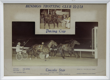
Photograph - Framed photo finish, Greg Matthews Photo, Lincoln Star, 22 February 1978
Lincoln Star won the Bendigo Pacing Cup on the 22 February 1978, followed by Mark Radium and Diamond Charger. Lincoln Star owned by Mr & Mrs RB Conroy, was trained and driven by RB Conroy. Lincoln Star raced from 1974 (2yo) through to 1979 (7yo). Career: 29 wins 15 seconds 19 thirds 139 starts. Refer to Identifier 15.178 (Media) for Full Career Performance Record.Two colour photographs, one small one large in a white frame. At the top: Bendigo Trotting Club 22-2-78/ Pacing Cup At the bottom: Left corner: Distance 2700 metres/ Mile rate 2.5 / Greg Matthews Photo Centre: Lincoln Star (Royal Dollar - Flora Scott) / Mark Radium 2nd / Diamond Charger 3rd Right corner: Owned by- Mr & Mrs RB Conroy/ Trained and driven by - RB Conroybendigo harness racing club, horses, race, winner, bendigo trotting club, pacing cup, driver, trainer, owner, 1978, lincoln star, mr & mrs rb conroy, mark radium, diamond charger, rb conroy, bob conroy, r conroy -
 Victorian Harness Racing Heritage Collection at Lord's Raceway Bendigo
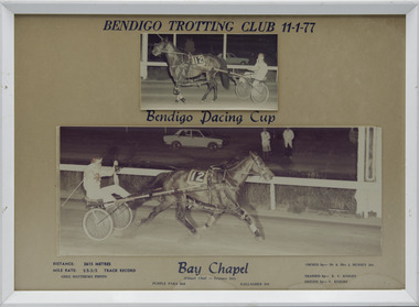
Photograph - Framed photo finish, Greg Matthews Photo, Bay Chapel, 11 January 1977
Bay Chapel won the Bendigo Pacing Cup on the 11 January 1977, followed by Purple Para and Gallagher. Bay Chapel owned by Mr & Mrs J Hussey Jnr, was trained by RV Knight, driven by V Knight. Bay Chapel raced from 1973 (2yo) through to 197 (8yo). Career: 23 wins 14 seconds 17 thirds 132 starts. Refer to Identifier 15.035 (Media) for Full Career Performance Record.Two colour photographs, one small one large in a white frame. At the top: Bendigo Trotting Club 11-1-77/ Bendigo Pacing Cup At the bottom: Left corner: Distance 2615 metres/ Mile rate 2.5.3/5 /Track Record / Greg Matthews Photo Centre: Bay Chapel (Chapel Chief - Princess Del) / Purple Para 2nd / Gallagher 3rd Right corner: Owned by- Mr & Mrs J Hussey Jnr/ Trained by RV Knight/ Driven by - V Knightbendigo harness racing club, horses, race, winner, bendigo trotting club, pacing cup, driver, trainer, owner, 1977, bay chapel, rv knight, mr & mrs j hussey jnr, purple para, gallagher, vj knight, vin knight, bob knight -
 Victorian Harness Racing Heritage Collection at Lord's Raceway Bendigo
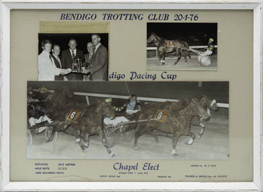
Photograph - Framed photo finish, Greg Matthews Photo, Chapel Elect, 20 January 1976
Chapel Elect won the Bendigo Pacing Cup on the 20 January 1976, followed by King's Mead and Thoron. Chapel Elect owned by MJ Tate, was trained and driven by K Pocock. Chapel Elect raced from 1974 (3yo) through to 1978 (7yo). Career: 17 wins 9 seconds 8 thirds 79 starts.Three colour photographs, two small one large in a white frame. At the top: Bendigo Trotting Club 20-1-76/ Bendigo Pacing Cup At the bottom: Left corner: Distance 2615 metres/ Mile rate 2.7.2/5 / Greg Matthews Photo Centre: Chapel Elect (Chapel Chief - Lady Pat) / King's Mead 2nd / Thoron 3rd Right corner: Owned by- MJ Tate/ Trained and driven by - K Pocockbendigo harness racing club, horses, race, winner, bendigo trotting club, pacing cup, driver, trainer, owner, 1976, chapel elect, mj tate, king's mead, thoron, ken pocock, ke pocock, k pocock, a robinson, alan robinson -
 Victorian Harness Racing Heritage Collection at Lord's Raceway Bendigo
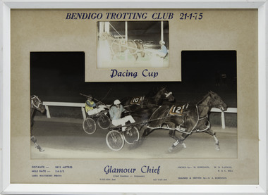
Photograph - Framed photo finish, Greg Matthews Photo, Glamour Chief, 21 January 1975
Glamour Chief won the Bendigo Pacing Cup on the 21 January 1975, followed by Yallara and Go Van. Glamour Chief owned by M Robinson, WR Lanyon, B & C Hill, was trained and driven by RA Robinson. Glamour Chief raced from 1970 (2yo) through to 1976 (8yo). Career: 29 wins 9 seconds 4 thirds 59 starts. Refer to Identifier 15.127 (Media) for Full Career Performance Record. Two colour photographs, one small one large in a white frame. At the top: Bendigo Trotting Club 21-1-75/ Pacing Cup At the bottom: Left corner: Distance 2615 metres/ Mile rate 2.6.2/5 / Greg Matthews Photo Centre: Glamour Chief (Chief Rainbow - Dainmont) / Yallara 2nd / Go Van 3rd Right corner: Owned by- M Robinson, WR Lanyon, B & C Hill/ Trained and driven by - RA Robinsonbendigo harness racing club, horses, race, winner, bendigo trotting club, pacing cup, driver, trainer, owner, 1975, glamour chief, ra robinson, m robinson, wr lanyon, b & c hill, yallara, go van, rex robinson -
 Victorian Harness Racing Heritage Collection at Lord's Raceway Bendigo
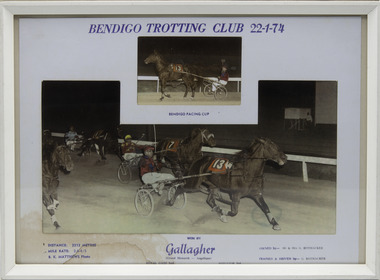
Photograph - Framed photo finish, BK Matthews Photo, Gallagher, 22 January 1974
Gallagher won the Bendigo Pacing Cup on the 22 January 1974, followed by Royal Gaze and Agitator. Gallagher owned by Mr & Mrs G Rothacker, was trained and driven by G Rothacker. Gallagher raced from 1972 (2yo) through to 1978 (8yo). Career: 38 wins 19 seconds 29 thirds 139 starts. Refer to Identifier 15.117 (Media) for Full Career Performance Record.Two colour photographs, one small one large in a white frame. At the top: Bendigo Trotting Club 22-1-74/ Bendigo Pacing Cup At the bottom: Left corner: Distance 2212 metres/ Mile rate 2.9.4/5 / BK Matthews Photo Centre: Won by Gallagher (Grand Monarch - Angelique) / Royal Gaze 2nd / Agitator 3rd Right corner: Owned by- Mr & Mrs G Rothacker/ Trained and driven by - G Rothackerbendigo harness racing club, horses, race, winner, bendigo trotting club, pacing cup, driver, trainer, owner, 1974, gallagher, mr & mrs g rothacker, g rothacker, royal gaze, agitator, gordon rothacker, gw rothacker -
 Victorian Harness Racing Heritage Collection at Lord's Raceway Bendigo
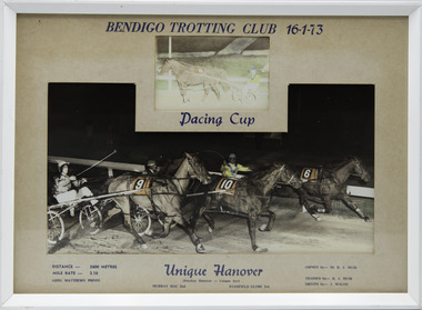
Photograph - Framed photo finish, Greg Matthews Photo, Unique Hanover, 16 January 1973
Unique Hanover won the Bendigo Pacing Cup on the 16 January 1973, followed by Murray Mac and Stanfield Globe. Unique Hanover owned by Mr KJ Muir, was trained by KJ Muir, driven by S Walsh. Unique Hanover raced from 1971 (3yo) through to 1975 (7yo). Career: 17 wins 10 seconds 10 thirds 81 starts.Two colour photographs, one small one large in a white frame. At the top: Bendigo Trotting Club 16-1-73/ Pacing Cup At the bottom: Left corner: Distance 2600 metres/ Mile rate 2.10 / Greg Matthews Photo Centre: Unique Hanover (Smokey Hanover - Unique Ayr) / Murray Mac 2nd / Stanfield Globe 3rd Right corner: Owned by- Mr KJ Muir/ Trained by KJ Muir/ Driven by - S Walshbendigo harness racing club, horses, race, winner, bendigo trotting club, pacing cup, driver, trainer, owner, 1973, unique hanover, kj muir, s walsh, murray mac, stanfield globe, stan walsh, kevin muir -
 Victorian Harness Racing Heritage Collection at Lord's Raceway Bendigo
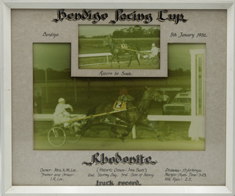
Photograph - Framed photo finish, Rhodonite, 11 January 1972
Rhodonite won the Bendigo Pacing Cup on the 11 January 1972, followed by Stormy Day and Son of Nancy. Rhodonite owned by Mrs KM Lee, was trained and driven by IR Lee. Rhodonite raced from 1969 (2yo) through to 1974 (7yo). Career: 21 wins 23 seconds 15 thirds 124 starts. Refer to Identifier 15.236 (Media) for Full Career Performance Record. Two colour photographs, one small one large in a white frame. At the top: Bendigo Pacing Cup/ Bendigo 11-1-72/ Return to Scale At the bottom: Left corner: Owner: Mrs KM Lee/Trainer and Driver IR Lee Centre: Rhodonite (Historic Crown - Ima Scott) / Stormy Day 2nd / Son of Nancy 3rd/ Track Record Right corner: Distance 13 furlongs/Margin 15 yds/Time 3.23/Mile Rate 2.5bendigo harness racing club, horses, race, winner, bendigo trotting club, pacing cup, driver, trainer, owner, 1972, rhodonite, ir lee, mrs km lee, stormy day, son of nancy, dick lee -
 Victorian Harness Racing Heritage Collection at Lord's Raceway Bendigo
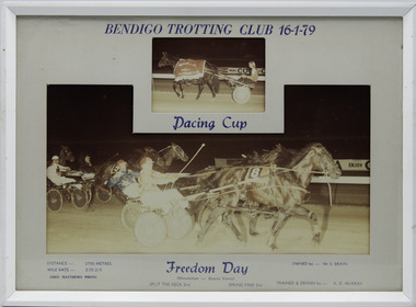
Photograph - Framed photo finish, Greg Matthews Photo, Freedom Day, 16 January 1979
Freedom Day won the Bendigo Pacing Cup on the 16 January 1979, followed by Split The Deck and Spring Find. Freedom Day owned by Mr S Brain, was trained and driven by KD Murray. Freedom Day raced from 1976 (2yo) through to 1982 (8yo). Career: 23 wins 25 seconds 16 thirds 175 starts.Two colour photographs, one small one large in a white frame. At the top: Bendigo Trotting Club 16-1-79/ Pacing Cup At the bottom: Left corner: Distance 2700 metres/ Mile rate 2.05-2/5 / Greg Matthews Photo Centre: Freedom Day (Minuteman - Beauty Vance) / Split The Deck 2nd / Spring Find 3rd Right corner: Owned by- Mr S Brain/ Trained and driven by - KD Murraybendigo harness racing club, horses, race, winner, bendigo trotting club, pacing cup, driver, trainer, owner, 1979, freedom day, kd murray, mr s brain, split the deck, spring find, kevin murray -
 Victorian Harness Racing Heritage Collection at Lord's Raceway Bendigo
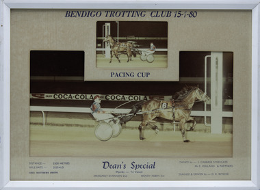
Photograph - Framed photo finish, Greg Matthews Photo, Dean's Special, 15 January 1980
Dean's Special won the Bendigo Pacing Cup on the 15 January 1980, followed by Margaret Shannon and Wendy Robin. Dean's Special owned by J Cabbage Syndicate, Mr E Holland & Partners, was trained and driven by DR Ritchie. Dean's Special raced from 1978 (3yo) through to 1984 (9yo). Career: 27 wins 11 seconds 2 thirds 80 starts. Refer to Identifier 15.304 (Media) for Full Career Performance Record.Two colour photographs, one small one large in a white frame. At the top: Bendigo Trotting Club 15-1-80/ Pacing Cup At the bottom: Left corner: Distance 2300 metres/ Mile rate 2.03-4/5 / Greg Matthews Photo Centre: Dean's Special (Pipiriki - Tri Vance) / Margaret Shannon 2nd / Wendy Robin 3rd Right corner: Owned by- J Cabbage Syndicate, MR E Holland & Partners/ Trained and driven by - DR Ritchiebendigo harness racing club, horses, race, winner, bendigo trotting club, pacing cup, driver, trainer, owner, 1980, dean's special, dr ritchie, j cabbage syndicate, mr e holland & partners, margaret shannon, wendy robin, des ritchie