Showing 575 items
matching landscape view
-
 Villa Alba Museum
Photograph - Vestibule, Villa Alba, 2011
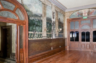
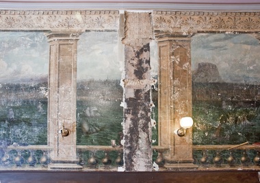
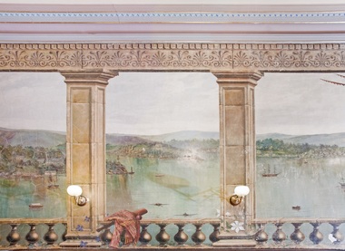
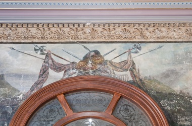
Built between 1882 and 1884 for the banker William Greenlaw and with interior decoration by the Paterson Brothers, a number of elements of the the interior design scheme reference Greenlaw’s Scottish origins. Following his death in 1895, from 1897 the house was leased and owned by a succession of owners including the Fripp family, the Royal Women’s Hospital and the Mount Royal Hospital before being sold to the Society of Jesus for Xavier College. In 2004 the title was transferred to Villa Alba Museum Inc., and the western section of the garden leased to Xavier College for 99 years. The photograph is one of a series of views of the interior commissioned from the photographer Russell Winnell by the Board of Management of Villa Alba Museum in 2011.villa alba museum, interior design - 19th century, paterson brothers - decorators - melbourne, russell winnell photography, vestibules - 19th century, ballrooms - 19th century, landscape murals - 19th century -
 Villa Alba Museum
Photograph - Vestibule, Villa Alba, 2011
Built between 1882 and 1884 for the banker William Greenlaw and with interior decoration by the Paterson Brothers, a number of elements of the the interior design scheme reference Greenlaw’s Scottish origins. Following his death in 1895, from 1897 the house was leased and owned by a succession of owners including the Fripp family, the Royal Women’s Hospital and the Mount Royal Hospital before being sold to the Society of Jesus for Xavier College. In 2004 the title was transferred to Villa Alba Museum Inc., and the western section of the garden leased to Xavier College for 99 years. The photograph is one of a series of views of the interior commissioned from the photographer Russell Winnell by the Board of Management of Villa Alba Museum in 2011.villa alba museum, interior design - 19th century, paterson brothers - decorators - melbourne, russell winnell photography, vestibules - 19th century, ballrooms - 19th century, landscape murals - 19th century -
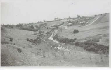
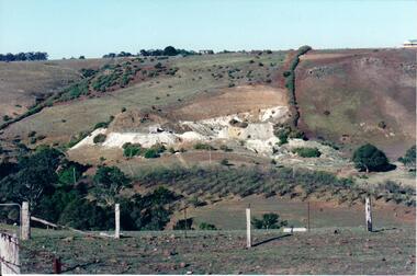 Hume City Civic Collection
Photograph, c Early 1990's
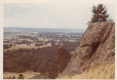
The Kaolin quarries at Bulla were an important industry in the district and supplied clay products to the Cornwell and Hoffman companies in Brunswick. The Kaolin deposits were found in the 1850's and were considered to be some of the largest in the colony.A landscape photograph of a valley with a post and wire fence and a partial view of a farm gate in the immediate foreground. A clump of native trees are on the LHS and a small grove of almond trees has been planted on the river flat. Kaolin quarry is on the hillside and two buildings can be seen on the hill top. High tension pylons are in the distance near the skyline.kaolin quarries, almond groves, bulla township, deep creek, hoffmans kaolin mine, hoffmans potteries, cornwell potteries, george evans collection -
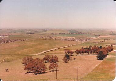 Hume City Civic Collection
Photograph, 1980s
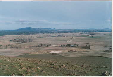
The photograph was taken above Reservoir Road on the lower slopes of Mt. Holden. It is looking south down Wilson's Lane towards some of the early Sunbury developments which grew around the Gap Road area in the early 1980s.A landscape coloured photograph with rounded corners. It is a panoramic view of Sunbury taken from the southern slopes of Mt. Holden. In the foreground there is a small cluster of trees and in the middle distance there is some evidence of housing development. Bald Hill can be seen on the skyline.wilson's lane, mt. holden, bald hill, sunbury, george evans collection -
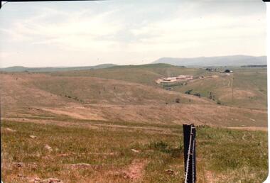 Hume City Civic Collection
Photograph, early 1980s
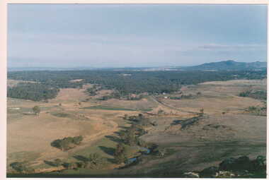
The Sunbury Tip was transferred from the end of Reservoir Road as housing development spread in that area to a site on the NW side of Mt. Holden near Riddell Road in the early 1980s.A landscape coloured photograph with rounded corners. It is a panoramic view of open country NW of Sunbury near Riddell Road. There is a fence post with barbed wire hanging from it in the immediate foreground and Macedon Ranges and part of the Western Highlands can be seen across the skyline.macedon ranges, mt. macedon, camel's hump, sunbury municipal tip, george evans collection -
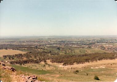 Hume City Civic Collection
Photograph, early 1980s
The Headland Estate housing development began in the early 1980s. It was situated west of Sunbury and was bounded by Elizabeth Drive, Reservoir Road, Phillip Drive and Stewart's Lane.A coloured landscape photograph with rounded corners of a view of Sunbury overlooking the Headland Estate before its development. There is a rocky outcrop on the LHS of the photograph and a lightly timbered area in the middle distance. Sunbury can be seen in the distance.headland estate, mt. holden, sunbury township, george evans collection -
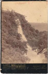 Hume City Civic Collection
Photograph
A mounted b/w photograph of a view of a waterfall (possibly at Craiglee).Printed on front: L. Davis / PORTRAIT AND LANDSCAPE ARTISTdavis, artists, waterfalls, craiglee, george evans collection -
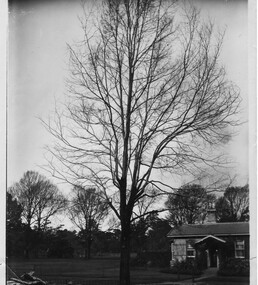 University of Melbourne, Burnley Campus Archives
Photograph - Black and white print, Garden View, Unknown
Note by T.H. Kneen,19 November 1991, " Not Burnley. Could be Fitzroy Gardens."Black and white photograph. A brick house in a garden or park settingfitzroy gardens, landscape design, park -
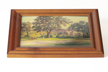 Chiltern Athenaeum Trust
Painting - Artwork, Fanny Bartley, Bartley's Brewery
Bartley's Brewery, Howlong Road, Chiltern (photograph of a painting by Fanny Bartley) Property owned by Benjaming Jackson Bartley 1834-1899Australian Impressionism, Naturalism, Colonial Art, Folk ArtA small, rectangular painting with a wood frame in a basic relief styleSignature in bottom right corner of paintingaustralian landscape, landscape, farm -
 Clunes Museum
Photograph
... history photography photographs clunes landscape VIEW OF THE CREEK ...VIEW OF THE CREEK AT CLUNESlocal history, photography, photographs, clunes, landscape -
 Clunes Museum
Photograph
VIEW OF THE CREEK AT CLUNES (CRESWICK CREEK - TULLAROOP)THE CREEK AT CLUNESlocal history, photography, photographs, clunes, landscape -
 Clunes Museum
Photograph
... history photography photographs clunes landscape COLOURED ...COLOURED PANORAMIC VIEW TAKEN FROM MT. GRENOCH LOOKING S.W.local history, photography, photographs, clunes landscape -
 Clunes Museum
Photograph
... history photography photographs clunes landscape COLOURED ...COLOURED PANORAMIC VIEW - TAKEN FROM MT.GRENOCK LOOKING SOUTHlocal history, photography, photographs, clunes landscape -
 Clunes Museum
Photograph
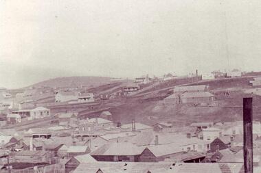
EARLY CLUNES BUILDINGSPHOTOCOPY OF EARLY CLUNES VIEWS OF BUILDINGS CHIMNEY STACKlocal history, photography, photographs, clunes landscape & buildings -
 Clunes Museum
Photograph, CIRCA 1879
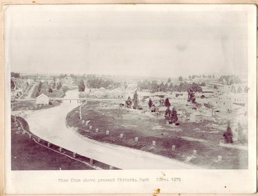
... history photography photographs bridges - buildings and landscape ...PHOTOGRAPH OF CLUNES TOWNSHIP, SHOWING THE TWO BRIDGES ACROSS THE CREEK.VIEW FROM ABOVE PRESENT VICTORIA PARK.local history, photography, photographs, bridges - buildings and landscape of clunes -
 Clunes Museum
Photograph
... history photography photographs clunes landscape COLOUR PHOTOGRAPH ...COLOUR PHOTOGRAPH PANORAMIC VIEW TAKEN FROM MT. BECKWORTHlocal history, photography, photographs, clunes landscape -
 Nillumbik Shire Council
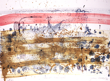
Mixed media: Liz NETTLETON, Liz Nettleton, Respite and Repose, 2010
... / Framing this view of the landscape is a pattern (topographical... in the foreground / Framing this view of the landscape is a pattern ...Nettleton creates an image of peace and tranquility after the violence felt from the 2009 Black Saturday bush fires / At the Arthurs Creek cemetery Nettleton found the grave of Reg Evans and Angela Brunton, friends who had perished in the fires / Nettleton sat on the edge of their joint grave and photographed their view / It was only after examining the photos more closely that she realized Mount Sugarloaf had burnt almost to the valley / Sugarloaf is always in an indigo haze. This work is by a local contemporary artist and encompasses themes dealing with the 2009 Black Saturday bushfires. Mixed media (acrylic paint, acrylic ink and indian ink) on board / Landscape painting of Mount Sugarloaf and green pastures after the 2009 Black Saturday bushfires / Mount Sugarloaf is depicted in an indigo haze in the background / A line of trees bathed in light border the mountain's edge / Lines of trees parallel to each other jut out diagonally in the foreground / Framing this view of the landscape is a pattern (topographical maps of the Nillumbik area), which suggest the vast extent of the devastated area of landscape. In black marker 'LIZ NETTLETON' + artist signature '2011' on back - middle right side nettleton, respite and repose, landscape, painting, mixed media, black saturday, mount sugarloaf -
 Nillumbik Shire Council
Print (Lithograph): John Olsen (b.1928 NSW), John Olsen, Tropical Rain Shower from The Bodford Terrace Suite, 1978
A typical Olsen painting combines an implied aerial view with an ambiguous and seemingly unpremeditated figuration. His characteristically quizzical line and irregular squiggles and dots deftly render countless organisms, large and minute. Their environment is conjured through loosely brushed and stained expanses of colour (on canvas or hardboard) and lines which sometimes read as geological mappings. In Olsen's work there is no foreground/ middle ground/ background, nor any sign of European landscape's concern with "human scale." Instead he employs simultaneously the contrary vantages of naturalist and geographer. 'Tropical Rain Shower' by John Olsen forms one of the eight artworks represented in the Bodford Terrace Suite. Eight of Australia's finest artists were brought together to create a folio of lithographic prints to celebrate the restoration of historic Bodford Terrace. Printed at the Druckma Press by John Robinson under the supervision of master printer Jock Abbott. The folio edition was limited to 300 signed and numbered folios. The lithographs were printed on special heavy weight french Arche's paper in accordance with the tradition of this artistic medium. Lithographic print on paper.Signed John Olsen '78, lower right hand corner. Edition 179/300bodfford terrace collection, john olsen, tropical rain shower -
 Nillumbik Shire Council
Mixed Media (installation): John R. NEESON (b.1956 AUS), John R Neeson, Riverbend Project, 2015
John R Neeson was a Laughing Waters Artist in Residence in 2015. During his residency Neeson made site specific trompe-l’oeil paintings and time based videos that referenced the changes of light upon the Knox architecture and the environment of Laughing Waters.Wooden easel holding an oil on board painting of the Yarra River and surrounding landscape at Laughing Waters (detailed view). Behind the painting and easel is a digital photograph of the painting and easel in situ in the landscape. The photograph is printed on aluminium. No inscriptions and markingsekphrasis 2016, neeson, easel, oil painting, yarra river, digital photograph, landscape, in situ, site specific, riverbend -
 Nillumbik Shire Council
Painting: Jodi WILEY, Afternoon Light, 2014
N/AJodi Wiley is a local artist who works in acrylic to create detailed images of trees found in urban and suburban environments. “Trees are ordinary features of our everyday landscape. And yet when the light hits them at certain times of the day, the colours and textures that are illuminated can make us gasp in awe if we are truly paying attention". 'Afternoon Light' was highly commended in the 2015 Nillumbik Prize, judged by Melinda Martin, Director of Linden New Art, Melbourne.Detailed, cropped view of a tree trunk, warm earth colours and tonesWhite, hand painted 'J' in bottom right cornerwiley, acrylic, art, painting, trees, landscape -
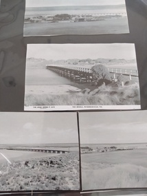 Peterborough History Group
Photograph - Four copies of photographs of the Peterborough Old Bridge
... connection to the East side of the river. A view of the landscape... to the East side of the river. A view of the landscape at that time ...Varying views of the old bridge, which was a valuable connection to the East side of the river. A view of the landscape at that time.Historic views of the town and bridge 4 photocopied reproductions of different aspects of the Old bridge at Peterborough, including one which is a copy of The Rose Series Postcards No P2470.peterborough, peterborough old bridge, curdies river bridge, rose series postcards, rose series p2470 -
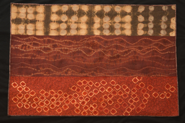 National Wool Museum
Quilt, Carolyn Sullivan, Out There, 2012
Entered for, and winner of, 2012 Expression: The Wool Quilt Prize. Artists statement: "Out there" refers to the wide view of the undulating land extending from our home acreage towards the escarpment and the coast. There are also the millions of small organisms that live out there. As well, out there is the vast Australian landscape which I find thrilling"Wool quilt in landscape orientation with three distinct design patterns, primarily orange/brown/red in colour. Top panel is a light brown background with paler circles inset. Middle panel is an ochre colour with horizontal uneven lines. Bottom panel is an orange colour with pale bordered square shapes. Artists panel on back bottom right corner. -
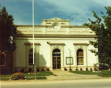 Stawell Historical Society Inc
Photograph, Stawell Shire Hall 1866 c1980s -- Coloured
Colour Photo Stawell Shire Hall built 1866, c1980. The Shire Hall is in Longfield Street Stawell and has had many changes since 1866. Ronald Campbell, the Shire's second president laid the foundation of the hall on 28th April 1866. The contractors were Hutchings and Delbridge. The first Hall and office were the front part of the existing building. These rooms consisted of two 18 ft square rooms with an entrance hall separating them. The facade was almost the same as it is today. The building cost 502 pounds.Colour photograph of Stawell Shire Hall 1866. Very similar view to 0084 the photo clearly showing the two windows and arched entrance door. Landscaping outside the building is exactly the same as in 0084. stawell -
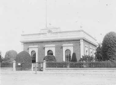 Stawell Historical Society Inc
Photograph, Stawell Shire Hall 1866
Stawell Shire Hall built 1866 Hewitt Photo. A professional photograph of the Shire Hall showing the road and footpath in front of the building. The view shows three side windows and two at the front opf the building with four urn shaped decorations on top of the building. A flag post can be seen behind the central building decoration on the roof above the entrance doorway. The landscape around the building is well manicured with tall to medium sized shrubs. Stawell Shire Hall built 1866. Black & white photograph showing a front and side view of the building. This photo shows three side windows compared to an earlier photo, 84.2 where only one side window can be seen.Stawell Photographic Co. Close Railway Station C. HEWITT, Managerstawell -
 Stawell Historical Society Inc
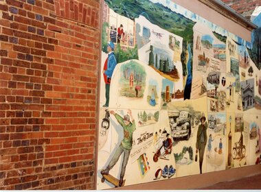
Photograph, Pioneer Walk -- 3 Photos
Three colour photos of Pioneer Walk located between Main & Church Streets Stawell, photos taken in November 1992. One photo is of Big Hill and the other two of people and scenes and mining in Stawell.Three colour photos of collages decorating a walkway. The scenes are of people, building and landscapes. Copies also found in Album 4, p.49-50.151 Stawell History Mural, eft panel. Nov. 1992 151 Stawell Mural in Pioneer Walk Nov/92 151.1 Stawell Mural, center section Big Hill view. Nov.1992stawell -
 Stawell Historical Society Inc
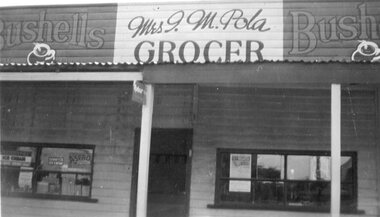
Photograph - Shop Front, Mrs I.M. Pola - Grocer
Stawell BusinessB/W Landscape - Shop front of Mrs I.M Pola advertisments in window Bushells ads eithe rside of propietors name. weatherboard with iron roof Bushells Mrs I.M. Pola Bushells Grocer On Rear written in blue: Front view of shop 117 Patrick Street Stawell, Owned by Mr T May. Then by Mr P.A. Pola, left in will to mrs I.A. Pola in 1945stawell shops businesses streetscape -
 Latrobe Regional Gallery
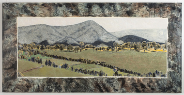
Painting, Fifteen Views of Gippsland, 1978
... gippsland Gippsland views landscape Not signed. Not dated. Synthetic ...Synthetic polymer paint on canvasNot signed. Not dated.gippsland, views, landscape -
 Whitehorse Historical Society Inc.
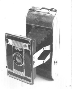
Equipment - Camera, C1939
Purchased by Ted Arrowsmith in 1940 from chemist at 596 Station Street Box Hill, when he lived at 35 Cambridge Street Box Hill. Used by him until the 1960s. Carried throughout Australia and the South West Pacific War Zone in the R.A.A.F between 1942 and 1946.Black folding bellows camera.AGFA 127. Folds back into a narrow case with handle. Instruction book included.|Agfa - Bilinar lens - aperture f11to f22. Two view finders one Portrait and other Landscape. Fixed speed of 1/30th second plus time exposure.AGFA - Bilinar. Made in germany.photography, cameras