Showing 1773 items
matching maps and plans
-
 Bendigo Historical Society Inc.
Map - PART PARISHES OF MANDURANG AND SANDHURST, No date visible
Map: Section of Parish plan of Bendigo covering Mandurang, Diamond Hill, and Quarry Hill, ( number 147 in Map Cupboard 1).Map 11map, bendigo, city streets, parish of mandurang, parish of sandhurst, diamond hill , quarry hill -
Bendigo Historical Society Inc.
Map - BENDIGO WEST IRRIGATION SETTLEMENT, 27/07/1910
Map: bendigo West Irrigation Settlement, Parish of Sandhurst, County of Bendigo. Parish plan ( number 193 in Map Cupboard 1)map, bendigo, irrigation settlement, bendigo west irrigation settlement -
Bendigo Historical Society Inc.
Map - BENDIGO WEST IRRIGATION SETTLEMENT, 13/02/1909
Map: Bendigo West Irrigation Settlement, Parish of Sandhurst, County of Bendigo. Parish plan. ( number 191 in Map Cupboard 1)map, bendigo, irrigation settlement, bendigo west irrigatioon settlement -
Bendigo Historical Society Inc.
Map - BENDIGO, October 1st 1893
Map: Bendigo, Plan of the whole county of Bendigo showing areas now available for selection (number 256 in map cupboard 1)map, bendigo, lands available for selection, bendigo, land available for selection -
Bendigo Historical Society Inc.
Map - TOWNSHIP OF HEAHCOTE SHEET 1, 29/07/1935
Map: Township of Heathcote sheet 1, parish of Heathcote, County of Dalhousie. Parish plan (number 253 in map cupboard 1)map, dalhousie, township, heathcote, conty of dalhousie -
Bendigo Historical Society Inc.
Map - PARISH OF EGERTON, 19/03/1894
Map: Parish of Egerton, Settlement on Lands Act 1893, County of Bendigo. Parish plan ( number 245 in Map Cupboard 1)map, bendigo, settlement on lands act 1893, egerton, settlement on lands act 1893. -
Bendigo Historical Society Inc.
Map - SANDHURST (PART), Circa 1880's
Map: Parish plan showing an area from McKenzie/View streets to Long Gully ( number 232 in Map Cupboard 1)map, bendigo, parish plan, sandhusrt, mckenzie street , view street, long gully -
Bendigo Historical Society Inc.
Map - LOCKWOOD, November 25th 1855
Map: Garden Allotments within the Town Reserve of Lockwood on the Bullock Creek. Parish plan (number 273 in map cupboard 1)map, bendigo, parish plan, lockwood, garden allotments, bullock creek -
Lakes Entrance Historical Society
Book, Town and Country Planning Board Melbourne, Gippsland Lakes Strategy, 1978
A strategy plan to guide future development of the Gippsland Lakes in a rational manner, to benefit all residents and visitors to the area. Contains plans and mapsgovernment, community facilities, recreation -
 Phillip Island and District Historical Society Inc.
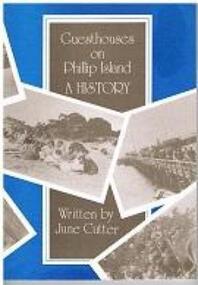
Book - Book, softcover, Guesthouses on Phillip Island : a history, 1987
Historical169 p. : ill., facsims., maps, plans ; 25 cm. ISBN 0731600088 phillip island, accomodation, guesthouses, history, housing, julie cutter, 1987, broadwater guesthouse cowes phillip island, carisbrooke guesthouse cowes phillip island, bayview house, osbourne park guesthouse phillip island, erehwon guesthouse, isle of wight hotel -
Federation University Historical Collection
Booklet, Buninyong Heritage Walks and other Interesting Cycle Rides and Scenic Drives, 2008
Blue soft covered book, with maps, plans and photographs relating to Buninyong, Victoria. buninyong, de soza park, buninyong tannery, buninyong railway station, eagle hotel, old buninyong library, hastie's hill, buninyong town hall, hastie's spring, crown hotel, buninyong post office, bowen tree, aborigines, buninyong primary school, buninyong cemetery, gold monument, mount buninyong, lal lal falls -
 Bendigo Historical Society Inc.
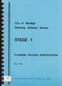
Book - CITY OF BENDIGO PLANNING SCHEME REVIEW STAGE 1, 1978
City of Bendigo Planning Scheme Review Stage 1. 101 pages, with maps.Meldrum Burrows & Partnersbendigo, planning, policies, bendigo, planning, planning scheme. -
 Bendigo Historical Society Inc.
Map - JACK FLYNN COLLECTION: TARNAGULLA SHEET 4, 25/11/1926
Map: Parish of Tarnagulla Sheet 4, Counties of Gladstone and Bendigo. Parish plan.Photo-Lithographed at the Department of lands and Survey, Melbourne by W. J. Butson. 25.11.26map, gladstone, parish plan, tarnagulla sheet 4 -
 Bendigo Historical Society Inc.
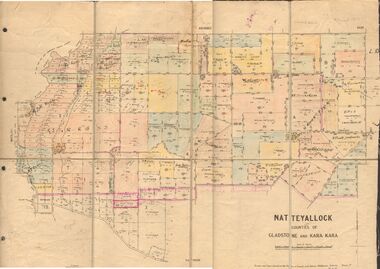
Map - JACK FLYNN COLLECTION: NATTE YALLOCK, 22/06/1937
Map: Parish of Natte Yallock, Counties of Gladstone and Kara Kara. Parish plan.By Authority H.J. Green Government Printer Melbourne. Drawn and Reproduced at the Depart., of Lands and Survey, Melbourne, Victoria.map, gladstone, parish plan, natte yallock -
 Bendigo Historical Society Inc.
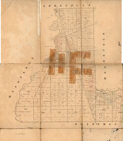
Map - JACK FLYNN COLLECTION: LAANACOORIE, No date visible
Map: Parish of Laanacoorie, County of Bendigo. Parish plan. Half of the sheet is missing.By Authority H.J. Green. Govt, Printer.map, bendigo, parish plan, laanacoorie -
 Bendigo Historical Society Inc.
Map - JACK FLYNN COLLECTION: VILLAGE OF BETLEY, 30/06/1874
Map: Village of Betley, on the Bet Bet Creek, Parish of Dunolly. Parish plan.Photo Lithographed at the Department of Lands and Survey Melbourne by J. Noone 30.6.74map, gladstone, village, betley, bet bet creek, dunolly -
 Bendigo Historical Society Inc.
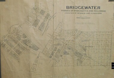
Map - JACK FLYNN COLLECTION: BRIDGEWATER, 10/09/1931
Map: Bridgewater, Parishes of Bridgewater and Inglewood, Counties of Bendigo and Gladstone. Parish plan.map, bendigo, parish plan, bridgewater inglewood -
Bendigo Historical Society Inc.
Map - NERRING SHEET 3, 1/12/1894
Map:Neriing sheet 3. parish plan ( number 188 in Map Cupboard 1)map, bendigo, parish plan, nerring -
University of Melbourne, Burnley Campus Archives
Article - Photocopy, Gardens of the Horticultural Society, 1867
Newpaper article about progress of the gardens, plus Yarra Planning Scheme mapgardens -
Clunes Museum
Map, F.W. NIVEN 34 STURT ST. BALLARAT & EMBOSSER
... MAPS ...SCROLL - SURVEVOR MAP AND PLAN OF NEW CRESWICK GOLD FIELDS SURFACE LEVELSlocal history, document, maps, mining - maps -
Koorie Heritage Trust
Book, Osborn, Betty et al, Maryborough, a social history, 1854-1904, 1985
The authors have given a picture of Maryborough from the earliest rough life on the diggings when a full-scale rebellion was narrowly averted over an incident at Tipperary Hill, to life at the turn of the century when a more sophisticated society had developed. Maryborough-History-1854-1904. Aborigines, Australian-Maryborough-Jajowurrong. (Dja Dja Wurrung); Aborigines-poisoningxx, 420 p. : ill., facsims., maps, plans, ports. ; 24 cm.The authors have given a picture of Maryborough from the earliest rough life on the diggings when a full-scale rebellion was narrowly averted over an incident at Tipperary Hill, to life at the turn of the century when a more sophisticated society had developed. Maryborough-History-1854-1904. Aborigines, Australian-Maryborough-Jajowurrong. (Dja Dja Wurrung); Aborigines-poisoningmaryborough (vic.) -- history. -
Whitehorse Historical Society Inc.
Map, Melbourne Metropolitan Planning Scheme. Map No 39, c1950
... maps ...Map of central Melbourne showing planning zones with gardens and principal buildings marked.Map of central Melbourne showing planning zones with gardens and principal buildings marked.Map of central Melbourne showing planning zones with gardens and principal buildings marked.maps, city of melbourne, city of fitzroy, city of south melbourne, city of collingwood -
 Whitehorse Historical Society Inc.
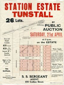
Pamphlet - Document, Station Estate Tunstall, 1923
Land Plan for auction of estate at Tunstall.Land Plan for auction of estate at Tunstall. Original in Haughton Maps, Latrobe LibraryLand Plan for auction of estate at Tunstall. auctions, station estate tunstall, s. s. sergeant (agent) -
 Kew Historical Society Inc
Book, Helen Baker, Historic Buildings: Windsor and Richmond, 1967
[Sydney], 1967 67 p. : illus., facsims., maps, plans ; 26 cm. non-fictionhistoric buildings - windsor (nsw), historic buildings - richmond (nsw) -
 Bendigo Historical Society Inc.
Map - KANGAROO FLAT ?, Circa 1880
Map: Parish plan showing area from Kangaroo Flat to Spring Gullymap, bendigo, parish plan, kangaroo flat, spring gully -
Bendigo Historical Society Inc.
Map - CAMPBELL COLLECTION: BENDIGO AND DISTRICT MAPS, 23-4-29
Map. Whirrakee, Parish of Whirrakee, Total area 4419 acres, scale 20 chains to 1 inch. Unused water race in centre of map. Eucalypt Oil Distillery, bottom of map. Prepared in W.P.B. from Assessor's Plan and Parish Plan. G.W.Latimer 23-4-29. (number 385 in map cupboard 1)G.W.Latimermap, bendigo, agricultural lands -
 Bacchus Marsh & District Historical Society
Map, Maddingley Township, Parish of Parwan, County of Grant, 1856
Maddingley is a locality or township within the broader township area of Bacchus Marsh. This map is dated 1856 but is based on an earlier survey in 1843. The main area of Maddingley shown on this map is an area bounded by Bacchus Street, Moore Street, Griffith Street and Franklin Street. Other streets visible are Inglis Street, Labilliere Street, McCrae Street. The area to the east of Franklin Street is not sub-divided and is described as an 'alluvial flat. A single page paper map showing land allotments, streets, and natural watercourses in the township of Maddingley. The map is pasted into a bound volume containing 76 maps or plans in total. Two inscriptions: 1. A.J. Skene Surveyor, 1843. ; 2. Surveyor-General's Office Melbourne, Sept 6, 1856. (Lithographed by R. Meikle)bacchus marsh victoria maps, maddingley victoria maps, land use, maddingley victoria history -
Whitehorse Historical Society Inc.
Legal record - Land Title, Musk Street, Blackburn
Land Titles referring to No. 1 Musk Street, BlackburnLand Titles referring to No. 1 Musk Street, Blackburn : 1. Vol. 542 Fol. 108222, James William Barnes, 1872; 2. Vol. 1877, Fol. 375367, Freehold Investment and Banking Company of Australia Limited, 1886; 3. Transfer 1507851 to John Thomas Williams, 1932; 4. Vol. 8109 Fol. 997 William Henry Rogers, 1955, with Plan of Subdivision CP 21670; 5. cadastral map, AMA zone 55, Sep 2000.Land Titles referring to No. 1 Musk Street, Blackburn musk street, blackburn, no. 1, maple street, blackburn, lawson street, blackburn, elder street, blackburn, barnes, james william, freehold investment and banking company of australia ltd, springfield road, blackburn, whitehorse road, blackburn, barnes estate -
Bendigo Historical Society Inc.
Map - CAMPBELL COLLECTION: BENDIGO & DISTRICT MAPS, 14-6-29
Map. Eppalock, Sedgwick and Strathfieldsaye. Scale 20 chains to 1 inch. Total area 3972 acres. Prepared in W.P.B. from Assessment Plan and Parish Plans. H.A. Darby. (number 378 in map cupboard 1)H.A.Darbymap, bendigo, agricultural lands -
 Warrnambool and District Historical Society Inc.
Letter Book 3, 1901 - 1908, 1900
This letter book has letters, plans and maps and dates from 1901 to 1908. It came from the office of John William Crawley, Junior, an engineer, architect and surveyor in private practice in Warrnambool and also the engineer for the Shire of Warrnambool from 1895 to 1935. His father, brother and son were also engineers and worked in that capacity or as the Shire Secretary for the Shire of Warrnambool, with the Crawley family recording a total of 132 years of service to the Shire. The letter book was passed on to John Crawley’s son, Rolf, engineer for the Shire of Warrnambool from 1935 to 1968. The letter book then came into the possession of Michael Hand who took over the private surveying business of Rolf Crawley in Warrnambool. The Warrnambool and District Historical Society has acquired the letter book, one of several Crawley ledgers, from the Michael Hand estate. The Shire of Warrnambool existed from 1863 to 1994. This letter book is of considerable significance as it contains maps, plans and letters produced by John William Crawley Junior, the engineer for the Shire of Warrnambool for 40 years. It will be very useful for research. This is a hard cover letter book of 717 pages. It has a black cover with brown leather binding on the cover edges and spine. The leather is worn away in places. The letter book contains an alphabetical index, handwritten letters, sketch plans and maps. There is a mauve stamp on the inside front cover. ‘3’ ‘Letter Book 1901 to 1908’ ‘Letter Book J.Wm. Crawley’ ‘Rolf L. Crawley, Civil Engineer, Drainage and Water Supply Engineer, Licensed Surveyor, Registered Architect, Warrnambool’ john william crawley junior, warrnambool, rolf crawley, warrnambool, history of warrnambool