Showing 1007 items
matching paddocks
-
 Bendigo Historical Society Inc.
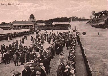
Postcard - BASIL WATSON COLLECTION: THE PADDOCK, BROOKLANDS UK
Black and white postcard. On top of card:' The Paddock, Brooklands' Image shows large amount of people, mainly men, standing in area near racetrack. Large pavilion in background.Valentine's Seriesevent, sports, brooklands racetrack, weybridge, uk -
 Tatura Irrigation & Wartime Camps Museum
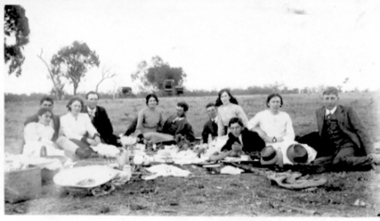
photo, Picnic c1920s
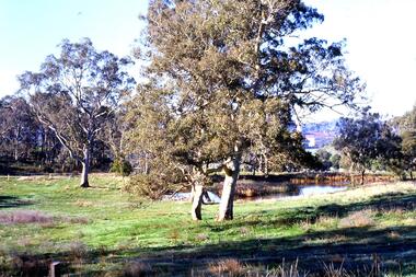
Picnic in a paddock near Tatura c1920s.|Same group of people, see photo no.10121|Maybe same group of people in photo no.10122|Second copy of this photo, no.10123tatura, picnic, costume, female, male -
 Tatura Irrigation & Wartime Camps Museum
photo, Picnic c1920s
Picnic in a paddock near Tatura c1920s.|Same group of people, see photo no.10121|Maybe same group of people in photo no.10122|Second copy of this photo, no.10120tatura, picnic, costume, female, male -
 Southern Sherbrooke Historical Society Inc.
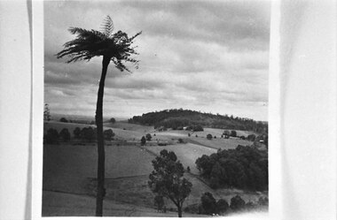
Photograph, Cotswold Valley, Menzies Creek
B&W photo showing the Cotswold Valley, Menzies Creek. It shows fenced paddocks, trees and hedges dotted around. A tall treefern in the foreground. A wooded hill in the background. -
 Sunbury Family History and Heritage Society Inc.
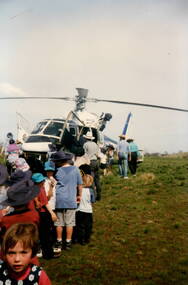
Photograph, Police Helicopter, c Early 1990s
The police flew the helicopter and landed in the Bulla Primary School ground. On that occasion a policeman spoke to the students and informed them about the role of the police helicopter and also outlined the physical aspects of the craft. In this photograph the children were lined up so that each one was able to see inside the helicopter. The children gained an understanding of the importance of the Police Rescue Helicopter in safety. A non-digital coloured photograph of children lined up to see inside the helicopter that has landed in an open paddock. A number of adults are supervising as the children file past the helicopter.policemen, police helicopters, bulla primary school -
 Lakes Entrance Historical Society
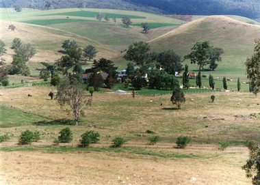
Photograph - Buchan Station, Tambo Shire, 1994 c
Also second identical copyColour photograph of Buchan Station, shows farming buildings situated among trees, both cultivated and uncultivated paddocks around property, forested hills in background. Buchan Victoriaagriculture, animals, topography -
 Lakes Entrance Historical Society
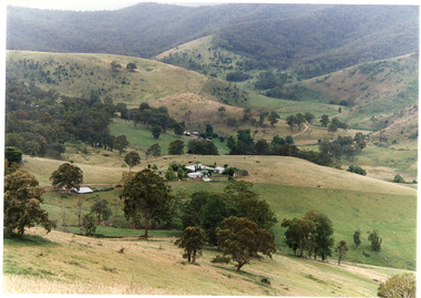
Photograph - Gillingal Station, Tambo Shire, 1994 c
Also second identical copyColour photograph of Gillingal Station, showing the farm buildings situated on a hillside and surrounded by rising hill country and fertile valleys, cattle grazing in home paddock. Buchan Victoriaagriculture, primary industry -
 University of Melbourne, Burnley Campus Archives
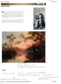
Photograph - Web page, Sue Murphy et al, The Survey Paddock 1861, 1861-2011
Copy of Scan of photograph of painting in the National Gallery of Australia collection, "The Survey Paddock 1861" by Nicholas Chevalier. Donated by Sue Murphy (FOBG Committee) 17 March 2011.painting, national gallery of australia, the survey paddock, 1861, nicholas chevalier, sue murphy, fobg, survey paddock -
 Greensborough Historical Society
Slide - Photograph, John Ramsdale, Plenty River flood plain: Slide 95, 1990s
Photograph shows water over paddocks; Plenty River flood plain.Part of the John Ramsdale collection of slides and audio visual material.Colour photograph scanned from slide.No maker's marks. No caption on slide.plenty river, plenty river flood -
Glenelg Shire Council Cultural Collection
Photograph, n.d
Sourced from Casterton Town Hall (former Shire of Glenelg)Black and white photograph showing erosion of gully near Casterton. Roots of trees visible in banks, old shed and cows in paddock, hills behind. Similar to 7219, different angle. -
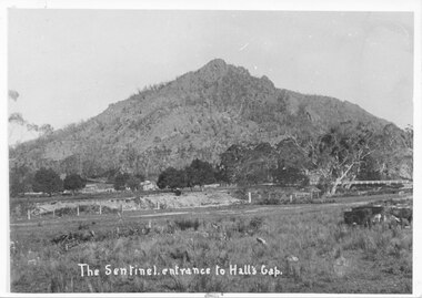 Halls Gap & Grampians Historical Society
Photograph, C 1910s
This is a picture of Sentinal Peak, showing Delley's Bridge and Delley's house. This is the second bridge built over Fyans Creek in 1911. The house is Delley's Inn, which became a regular stop-off for thirsty travellers.The photo shows a rocky peak. In the middle distance, in front of the peak, is a house on the left and on the right a wooden bridge can be seen crossing a creek. In the foreground is the creek with a fenced paddock in front of it.access routes, roads, scenery, peaks -
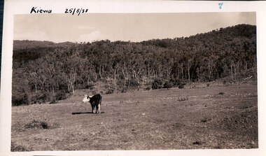 Kiewa Valley Historical Society
Black and white photograph of farmland, Kiewa, 25/8/38, circa 1938
This photograph was taken in August, 1938, some eight years prior to the establishment of Mt. Beauty a a township. The area was still being used for grazing, and the land was eventually acquired from the local land owners by the State Electricity Commission. The construction of the road, from Tawonga to the High Plains, was commenced in April, 1938 and this photograph was taken August, 1938. This allowed men and heavy equipment to be transported to the work sites for the construction of the Kiewa Hydro Electric Scheme. Prior to this access was by bridle trail, either on horse back or on foot. By 1946 housing construction had commenced for the new town of Mt. Beauty and by 1948 street construction in the southern part of the town was completed as far as Hill Street.This photograph is important as it shows the upper Kiewa Valley as it was before the establishment of the town of Mt. Beauty. The land has been cleared of natural vegetation to allow grazing of cattle. Black and white photograph of grazing farmland with one animal standing in the paddock. The area could possibly be where the golf course now stands with the road to the high plains not yet commenced.Handwritten in the upper left hand corner 'Kiewa 25/8/38'. The number 7 has been stamped in the upper right hand corner. It is part of a set of 8 photographs. On the back are the words Velox repeated several times, indicating the type of photographic papergrazing, kiewa, mt. beauty, secv -
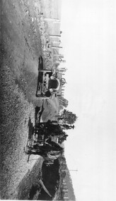 Kiewa Valley Historical Society
Photo: Making of Kiewa Valley Highway at Tawonga
The Kiewa Valley Highway was/is a major road along the Kiewa River ending at Mt Beauty the site of the S.E.C.V. town built for the construction of the K.H.E.S.Black and white photo with roofless old car beside two horses pulling a cart with man behind the cart. All coming towards the photographer on a road with paddocks on each side.kiewa valley highway, road building -
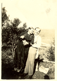 Federation University Historical Collection
Photograph - Black and White, Scott's, Sarah and Alex? Wright (at Sewell's?), circa 1930
Alex Wright travelled to England in 1930 and was known as the Prince of Mimic although his stage name was Navarre. He died in an air raid in the Hippodrome Birmingham in 1940. Alex was the brother of Frank Wright who was a renown resident of Smeaton, where he was born. He lived at Laura Villa, and attended Smeaton State School. His father William was a gold miner and his mother's name was Sarah. Their family won many singing and instrumental awards. Frank was tutored by Percy Code and was awarded a gold medal for the highest marks in the ALCM examinations in the British Colonies at the age of seventeen years. He became the Australian Open Cornet Champion by the age of eighteen. A year later, Frank conducted the City of Ballarat Band, and later the Ballarat Soldiers’ Memorial Band. He formed the Frank Wright Frisco Band and Frank Wright and his Coliseum Orchestra. These bands won many South Street awards, and Frank as conductor won many awards in the Australian Band Championship contest. In 1933 Frank Wright sailed to England to conduct the famous St Hilda’s Band and was later appointed Musical Director of the London County Council, where he organized many amazing concerts in parks, in and around the London district. He was made Professor of Brass and Military Band Scoring and conducted at the Guildhall of Music and Drama. Frank was often invited to adjudicate Brass Band Championships around Europe, in Australia, including South Street and in New Zealand. The Frank Wright Medal at the Royal South Street competition is awarded to an individual recognized as making an outstanding contribution to brass music in Australia.Black and white photograph of a man in shirt, trousers and braces hugging a woman in a dark frock. They are standing in front of a fence with trees and a paddock in the background. They are Sarah Wright and her son Alex?.Printed on back - Printed at Scott's, Veloxsarah wright, alex wright, frank wright, navarre, smeaton, ballarat -
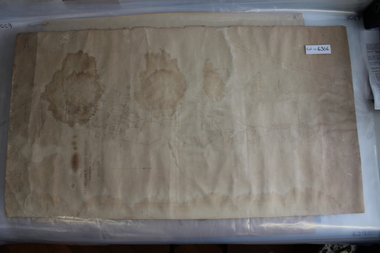 Coal Creek Community Park & Museum
Mine Map
6306.1 - Map of Outtrim mining area, with modification where damage/erasure has occurred. Shows tunnels, faults, tramways, boreholes, surface roads and (apparently) paddock boundaries and a creek. -
 Clunes Museum
Photograph, 2006
16 COLOURED PHOTOGRAPHS OF POWDER MAGAZINE, SITUATED IN A PADDOCK ON SMEATON ROAD APPROX, 2KM FROM TOWNSHIP ON LEFT HAND SIDE. IN DISTANCE TREES IN THE FOREGROUND SOME BOULDERS SHOWN.local history, photography, photographs, mining -
Whitehorse Historical Society Inc.
Article, Team digs discovery, 2007
Relics from Whitehorse's pioneering past found in paddock adjoining Schwerkolt Cottage & Museum Complex.Relics from Whitehorse's pioneering past found in paddock adjoining Schwerkolt Cottage & Museum Complex. Photos of Society President Judith Fry and members Valda Arrowsmith & Ian Nethercote.Relics from Whitehorse's pioneering past found in paddock adjoining Schwerkolt Cottage & Museum Complex. schwerkolt cottage & museum complex, fry, judith, arrowsmith, valda, nethercote, ian, manufactured objects -
Whitehorse Historical Society Inc.
Document, Finger's Paddock, 8/10/1902 12:00:00 AM
Copy of subdivision Auction Sale of Finger's Paddock, Doncaster by T. R. B. Morton & Coghill.Copy of subdivision Auction Sale of Finger's Paddock, Doncaster by T. R. B. Morton & Coghill. Blocks 3, 4, & 5 purchased by Frank Petty (grandfather of Bob Petty).Copy of subdivision Auction Sale of Finger's Paddock, Doncaster by T. R. B. Morton & Coghill. petty, frank, t. r. b. morton & coghill -
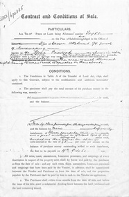 Whitehorse Historical Society Inc.
Document, Contract and conditions of sale, 1909
Copy of contract dated 19 April 1909 between the Freehold Investment and Banking Company of Australia Ltd and Julius Draeger. Portion of land allotment 94 known as Glebe Paddock.non-fictionland subdivision, glebe paddock, draeger, carl julius otto, freehold investment and banking company of australia ltd, t. r. b. morton & son -
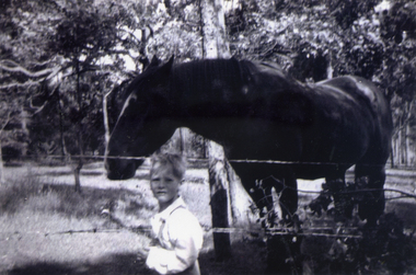 Whitehorse Historical Society Inc.
Photograph, Antonio Park - Mark with 'Clumpy Jim', C1960
The photo is part of a set provided by Robin Harris of his early life (1953-1962) in 'The Shack' at Antonio Park. See ND5241 for his story 'When Antonio Park was home'.)Black & white photograph of Mark Coleclough feeding 'Clumpy Jim'. The horse belonged to a neighbour. The paddock later became part of the Antonio Park Primary School. See ND5241 for history.antonio park mitcham, coleclough. mark, whitehorse road, mitcham, no. 627, bushfire - 1962 -
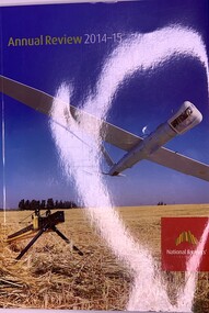 Beechworth Honey Archive
Publication, National Farmers' Federation Annual Review 2014-15, 2015
Soft Cover A4 size, front cover is of blue sky over a crop with a crop plane in the air. Back page is of a couple of farmers talking at a fence in a paddock 142 pages -
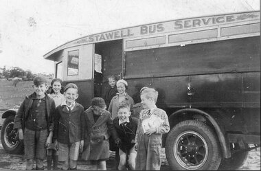 Stawell Historical Society Inc
Photograph, Our school Bus
Early school bus 4 boys in short pants, 1 in overalls with patterned jumper holding (unidentified), middle boy with cap and buttoned coat has mittens B/W Landscape Group Portrait 8 Children 6 Boyys, 2 Girls ( 4 Boys in uniform 2 with caps) In front of School bus Paddock behind bus Stawell Bus Servicetransport, education, stawell bus service -
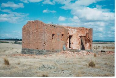
 Clunes Museum
Photograph, KODAK, C1800'S
VIEW OF POWDER MAGAZINE USED IN MINING DAYS TO STORE EXPLOSIVES. BUILDING MATERIALS - SOLID BRICKPOWDER MAGAZINE USE TO STORE EXPLOSIVES DURING THE DEEP LEAD GOLD MININGCOLOURED PHOTOGRAPH OF POWDER MAGAZINE EXTERIOR. SITUATED IN A PADDOCK ON SMEATON ROAD APPROX. 2 KM. FROM TOWNSHIP ON LEFT HAND SIDE. IRON POST AND WIRE FENCE IN FOREGROUND.powder magazine, photograph, local history -
 Clunes Museum
Photograph, KODAK, 1999
VIEW OF POWDER MAGAZINE USED IN MINING DAYS AT CLUNES TO STORE EXPLOSIVES. BUILDING MATERIALS SOLID BRICKCOLOURED PRINT OF POWDER MAGAZINE, SITUATED IN A PADDOCK ON SMEATON ROAD APPROX. 2 KM FROM TOWNSHIP ON THE LEFT HAND SIDE. IN DISTANCE TREES IN THE FOREGROUND SOME BOULDERS SHOWN.local history, photography, photographs, mining -
 Greensborough Historical Society
Slide - Photograph, John Ramsdale, Lower Plenty with Odyssey House in background: Slide 103, 1990s
Photograph shows gum trees in paddock. This is in Lower Plenty with Odyssey House in background.Part of the John Ramsdale collection of slides and audio visual material.Colour photograph scanned from slide.No maker's marks. No caption on slide.lower plenty, odyssey house -
 Greensborough Historical Society
Slide - Photograph, John Ramsdale, Looking towards Bulleen brickworks; Slide 126, 1990s
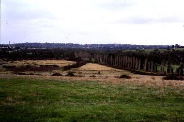
Photograph shows a rural view with paddocks and trees, looking towards Bulleen brickworks.Part of the John Ramsdale collection of slides and audio visual material.Colour photograph scanned from slide.No caption. Printed maker's mark on slide "Kodak Kodachrome Slide"bulleen -
Federation University Historical Collection
Plan, Ballarat Common, c 1890
Hand drawn ink plan or field notes for a survey on faintly ruled foolscap paper. Field notes or survey depicting Ballarat Commons, Ballarat Botanical Gardens, Police Paddock and Ballarat Cattle Yards Railways area. 'R.W.' at bottom, Verso 'Ballarat' with various calculations. -
 Orbost & District Historical Society
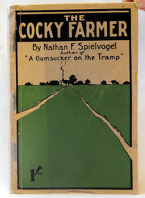
book, The Cocky Farmer, 1907
Nathan Frederick Spielvogel (1874-1956), teacher, writer and historian, was born on 10 May 1874 at Ballarat, Victoria. as well as his stories he published a number of Books about the history of Ballarat. Nathan Frederick Spielvogel (1874–1956) was a teacher, writer and historian. As a country schoolteacher, he traveled widely in the eastern Australian outback and also made a journey to London. Spielvogel gained distinction as one of the only Australian Jewish writers of his time. Many of his early books were best-sellers. A paper back book with 146 pp.written by Nathan Spielvogel. On the front cover is a drawing of a farm-house in a green paddock. The book is about school life and farming at Sale, Stawell, and the Wimmera district. the-cocky-farmer spielvogel-nathan literature -
 Bendigo Military Museum
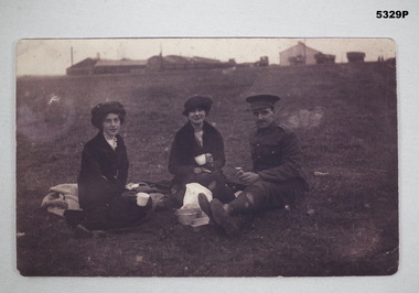
Photograph - PHOTGRAPH, WW1, c 1914-1919
Refers to the Service of Albert Edwards No, 5471 (English).This is a modern photocopy of a WW1 Group Portrait. It shows 2 young ladies and a British Uniformed soldier having a picnic on a grass paddock. In the background are numerous large buildings and vehicles of some sort.ww1, photo -
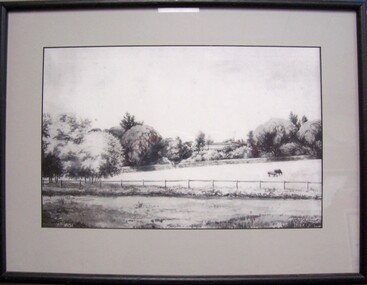 Glenelg Shire Council Cultural Collection
Drawing - Drawing - "Burswood", 1890
Displayed in History HousePen and ink sketch of a house partially obscured by trees. In foreground are two paddocks, with two horses grazing at centre right. Mounted in grey matt in black wooden frame, under glassFront: C G Darvall/Jan 1890