Showing 464 items
matching parcels
-
 Eltham District Historical Society Inc
Photograph, Liz Pidgeon, Heritage Excursion; East of Eltham, 6 Sep 2014, 20 May 2017
Newsletter No. 218, September 2014 September Excursion - East of Eltham Walk In Newsletter No. 197, March 2011, there was a brief history of Crown Allotment 15 Section 5 Parish of Nillumbik (CA 15) a parcel of land of a quarter of a square mile extending from Eucalyptus Road to Reynolds Road at the eastern extremity of Eltham. From the 1940s it was known as Stokes orchard. In later years it has been subdivided for residential purposes but leaving significant areas as power line and water supply reserves and bushland reserves that are habitat for the threatened For our excursion on 6th September we intend to walk through CA 15 to a bushland reserve east of Reynolds Road. The walk will traverse the boundary between suburban Eltham and the non-urban areas to the south and east. This is a pleasant walk through residential areas and bushland. Along the way we will discuss the early and more recent history of CA 15 as well as local natural history and geology. This walk is about 3.5 km in length and will take 2 to 2.5 hours. It will start at 2pm at the corner of Eucalyptus Road, Pitt Street and Nyora Road.Born Digitaleltham east, eltham district historical society, heritage excursion, activities, nyora road, reynolds road, gum tree road reserve, diosma road, stokes orchard, eucalyptus road -
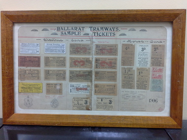 Ballarat Tramway Museum
Ephemera - Framed tickets, Electric Supply Co. of Vic (ESCo), "Ballarat Tramways - Sample tickets", 1906, 1966
Demonstrates and yields information about the ESCo tickets of 1906, shows the variety of tickets and passes used.Framed - wooden surround, glass, set of 26 actual tickets and two sketches of passes, timber backing board with the title "Ballarat Tramways - Sample tickets", dated 1906. Sets out the various tickets used by ESCo at the time and most likely used as a training aid for new conductors on both the electric and horse trams. Not to be displayed in light or hung up, that is display with care as fading is likely. See history of the object for details of the frame etc. Image i1 - as received from the City of Ballarat i2 - as repaired by by Kosnar's Picture framing. i3 - close up on the writing on the rear of the backing sheet i4 - detailed (1200dpi) image of the tickets. - 26.6 M i5 - image of the rear as received i6 - ditto - 600 dpi (Suitable for e-mail) - 7.2Mb See Reg Item 1846 for the newspaper clipping of Les Denmead handing the framed set of tickets to the City of Ballarat on 21/9/1971. Tickets comprise: Electric Tram Top Row: 2d - white - letter H - strip ticket requiring a trip ticket of the same value to be issued. 1 1/2d - white letter D - strip ticket requiring a trip ticket of the same value to be issued. 3d - off white, number 000,021 - Cash Adult - Up 2d - off white, number 000011 - Cash Adult - Up 2nd row 2d - check ticket - light red paper - number 000,011 - Up 1 1/2d - off white paper, number 000,011 - Up 3d - off white, number 000,021 - Cash Adult - Down 2d - off white, number 000011 - Cash Adult - Down 3rd row 2d - check ticket - off white paper - number 000,021 - Down 1 1/2d - check ticket - off white paper - number 000,021 - Down 1d - off white - number 000009 cash - child Up ticket 2d - off white - number 000021 cash - child Up ticket 4th row Employees only ticket - yellow, strip ticket School ticket - off white strip ticket - No. 6 1d - off white - number 000021 cash - child Down ticket 2d - off white - number 000021 cash - child Down ticket 5th row Drawing of Employees Bronze Medallion Drawing of pass issued to City Councillors and Officers of the Company Parcel ticket - No. 1 - 3d - to be attached to the parcel Parcel ticket - No. 1 - 3d - issued to the sender Horse Tram tickets 1st row 4d - off white paper - 36050 3d - white paper - 79701 2d - off white paper - 46401 2nd row 1 1/2d - off white - 81901 1d - off white - 99933 two 1 1/2 strip ticket - red two 4d daily return ticket - blue paper strip ticket 3rd row Monthly School ticket Sheet dated 6-9-06 with the initials SHS. "on the inside of the frame object was "Restored (?) and framed by Keith Russell Anderson, SEC Ballarat 26 Aug.1966"trams, tramways, tickets, esco, city of ballarat -
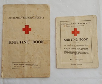 Mont De Lancey
Booklet - Knitting Patterns, Australian Red Cross, Australian Red Cross Society Knitting Book, c.1940's
Two Australian Red Cross knitting pattern booklets for home knitters, c.1940's. They were used by Ms Dorothy Hunter. These booklets were collected over 15 years and were used for exhibition at Memo, Gallery Healesville Friday 23rdOct to 18th November 2015.Two copies of Australian Red Cross Society Knitting Book, one small and one larger. The front cover shows the name of the society, a large red cross with the title Knitting Book underneath. The smaller book has information about the purpose of the Australian Red Cross Society in war times, Price: Threepence. Second Edition. The back cover has information regarding free carriage on S.A Railways and by Adelaide Steamship Company. It also has a 5 inches ruler on the left edge of the back cover.The larger book has the same title with the addition of Parcels addressed "Australian Red Cross" are carried free over the railways. On the back cover is printed Copies of this knitting book may be obtained upon application to any Red Cross Emergency Service Company in Victoria. Inside are various patterns for clothing - caps, sleeveless pullover, waistcoat muffler, armlets, man's socks and mittens, kneecaps, hot water bottle covers and scarves. non-fictionTwo Australian Red Cross knitting pattern booklets for home knitters, c.1940's. They were used by Ms Dorothy Hunter. These booklets were collected over 15 years and were used for exhibition at Memo, Gallery Healesville Friday 23rdOct to 18th November 2015.knitting, knitting patterns, knitting equipment -
 Eltham District Historical Society Inc
Photograph, 13 Stokes Place, Eltham, December 1980, 1980
Stokes Place was part of the Stokes Orchard Estate which was developed from the break-up of the the orchard owned by Frank Stokes who lived on the northeast corner of Nyora Road and Eucalyptus Road. His daughter Beryl advised that the Shire had levied a rate assessment on individual parcels of land within the orchard which became unaffordable resulting in its sub-division and sell off. The Stokes Orchard Estate was developed by Macquarie Builders in two stages starting with stage 1 in 1976. Stokes Place was part of Stage 2 in 1979. The Estate was bounded between Nyora Road, Eucalyptus Road, Diosma Road and Stokes Place. The original orchard only just reached the left most portions of Stokes Place and did not go fully up to Diosma, rather to just beyond the extant of Stokes Place. Stokes Place was known within the family as "The Oats" as that is where they grew oats. Frank Stokes moved to Eltham c.1945 after visiting Harold Bird to view his orchard, located diagonally opposite Stokes Orchard from the intersection of Eucalyptus Road, Pitt Street and Nyora Road. It was on Harold Bird's recommendation that Frank purchased the land.The Stokes Orchard Estate collection is typical of housing developments of the late 1970s and 1980s. It was one of the earliest estates in Eltham following the nearby Woodridge Estate development.Digital filestokes place, eltham, stokes orchard, stokes orchard estate, streets, houses -
 Rutherglen Historical Society
Photograph - Image, 1970s
Greatly relieved by his son’s safe return from war, John Richard Stanton (1872-1955) buys a parcel of productive farming land for his son John Charles “Jack” Stanton (1895-1989) to give him a “good start in life”. Jack’s wife Ethel Capper, devised the name “Gracerray” for the property to honour her sister Grace and the nearby Murray River. After the First World War, fourth generation Jack Stanton (1895-1989) with the help of his father started building a new winery (at the current site of the winery and cellar door) called ‘Gracerray’ named after his wife’s sister Grace and the Murray River. It is pronounced “Grah-sair-ray”. Jack built Gracerray around some existing cement open top vats from a winery that was demolished after phylloxera ravaged the region in the late 1890s. He used second hand materials from the defunct Great Southern gold mine and propped up the roof with huge tree trunks. Jack only made fortified wine up until the 1960s when he and his son-in-law Norman Killeen started making red wine to meet changing Australian tastes.Black and white portrait photograph of a mature man in suit and tie.On back of photo: "145% [upper case E in small circle] J.C. Stanton" wineries, north east victoria, wine industry, j c stanton, stanton & killeen winery, jack stanton -
 Bendigo Military Museum
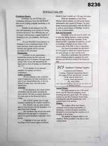
Work on paper - NEWSLETTER BRSL 1999, January 1999
This newsletter published in January 1999 by the President Bendigo RSL Alan Holmes is basically an Annual report of the Sub Branch in 1998. The 22 sub headings cover all aspects of the Sub Branch. The one photograph shows Norm Smart with his Life Membership Certificate on the left, on the right is Jack Barnes, Norm was the Treasure BRSL and Jack was the Secretary. Some of the main points are: Membership total 1998 being 797, 40 members had passed on, award of the French Legion of Honour to Jack Locket 108 years old, Anzac Day was a high standard with guest Speaker Ray Wheeler, Annual dinner guest speaker being Warick Johanson, Life Membership awarded to Norm Smart, 97 parcels had been delivered to Members in Care, Appreciation to Jack Barnes, Norm Smart & Peter Ball, 19 Bendigo RSL Members win the Edinburg Bowls Sheild, Museum report by Curator Peter Ball, Appeals report by Malcolm Angus raising in the two Appeals, ANZAC $29,223.35, POPPY $22565.20, List of the full Committee 1998 & next AGM to be February 8th 1999, the first Sandakan service and B.B.Cue to be held on Sunday March 7th at 11.00Newsletter, paper, 4 pages each folded, all print B &W, there are 22 sub headings, two advertisements and one large article re Whats on at the Bendigo & District Servicemen's Club, heading on first page is simply "Newsletter 1999" underlined, one photo showing two RSL Members.brsl, smirsl, newsletter, 1999 -
 Ballarat Tramway Museum
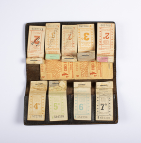
Functional Object - Ticket Wallet with 9 blocks of tickets, State Electricity Commission of Victoria (SECV), late 1960's
Demonstrates the method of dispensing tickets by conductors, how the tickets could be arranged, although the arrangement may not exactly represent the 1958-1963 arrangements of a ticket wallet. Yields information about the style and printing of tickets used in Ballarat and Bendigo tramways and how they were presented. Has a strong association with Travis Jeffery.Ticket wallet with a set of nine 1950-60's Ballarat tram tickets set up to represent a typical conductor's set of tickets by Travis Jeffrey, though these may not exactly line up with the fares at any one period - 1958 to 1963 following the introduction of concession tickets. Does not have a 3d City Section Ticket. 4000 - Sheet of leather, approx. 2mm thick, stained brown with four pockets formed on each side with another sheet of leather, stitched on all sides to form pockets to hold eight blocks of tickets. Stitching is a light cream or white colour cotton. The stitching on one side that forms the pockets has been removed, possibly by Travis, to present the tickets. 3992 - 7d black 3993 - 6d teal 3994 - 5d green 3995 - 4d brown 3996 - 4d Parcel check 3997 - 2d Red 3998 - 3d orange 3999 - 2d concession - red 4001 - 3d concession - orange 4002 - 2d City Section - red See Alan Bradley's notes "Fares in Ballarat"trams, tramways, secv, tickets, conductors -
 Rutherglen Historical Society
Letter, Goff Buchan, 28/02/1918 (Exact)
Found in a tobacco tin by David Gillespie in a house near the water tower. Not known who Goff Buchan was. Goff Buchan has now been identified. See comment below.Pencil written letter, one page on one side on yellowing lined paper and tobacco tin in which it was found. Tin contained at one time Happy Thoughts TobaccoLetter: "Palestine / 28 Feb 1918 / Alick / Your welcome card just arrived. Pleased to hear you are doing well. That's not a very appropriate card to send to a fellow out on this desert where he never sees a woman. But it caused some fun. Well Jack Old Boy, I am in hospital at present with a crook knee caused through that gentle sport called football, but will soon be out. I didn't get that parcel [Dougie?] sent. I would have liked to have got it too, but never mind, better luck next time. Well, remember me to all the boys. Give my love to all at home. / Your Loving Brother / Goff Buchan"letter from soldier, goff buchan, world war 1, godfrey buchan, 3rd lighthorse, 8th lighthorse, alexander buchan, alick buchan, buchan family, world war i, ww1, wwi -
 Bendigo Military Museum
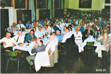
Photograph - BENDIGO RSL ANNUAL DINNERS, C.1998 - 2000
The photos are of one of the last Annual Bendigo RSL Dinners held in the SMI, this is most likely 1998/2000. The Dinners moved to the Bendigo District RSL Sub Branch Inc at Havilah Road about 2001. There are a number of easily identifiable members in the photos. .1) Centre Table, Fred Addlem, Kevin Purdon, Kell Howard, Peter Ball. .2) LH table, Joe Boulton, Ernie Jackman, Jack Fay. Fred Addlem, Refer Cat No 8128P for Committee history, he was also a dedicated Museum guide from 1998 to 2003. Kevin Purdon, has been a Museum Guide since 2009 to current, Appeals for many years and delivery to and pick up from schools. Laurie schilling committee member 1992 to 2000, museum guide from 1998 tp 2015. Kell Howard committee member 1976 to 1981, 1985 to 1990. Peter Ball, refer Cat No 8071.3 Joe Boulton, committee member 1999 to 2000, Appeals Officer with his wife Lyn from 2004 to 2012. Ernie Jackman, committee member 1961 to 1962, 1973, Welfare Sub Committee 15 years, Welfare Officer 1997 to 1978, Appeals Officer 1960 to 1994, organised the distribution of parcels to homes and hospitals at Xmas, made a Life Member 1986. Jack Fay, refer Cat No 8129PTwo Colour photographs re Bendigo RSL Annual Dinners taken from different angles showing 3 lines of tables set up. These photos are one of the last Annual Dinners held in the Soldiers Memorial Institute. The photos show the Museum memorabilia around the walls.brsl, smirsl, annual dinner -
 Bendigo Military Museum
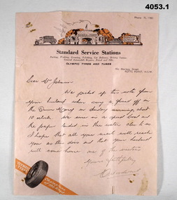
Letter - LETTERS WW2, 2) 20.10.1940
Harold James Thomas Johnson TX3956 enlisted on 25.7.1940, aged 37. Served with the 7th Division Ammunition Supply Coy A.A.S.C as a driver. He was discharged om 30.11.1945 with the rank of L/Cpl. .1) Letter is to 'Dear Mrs Johnson". The contents of the note relate to the writer picking up the note which was thrown over the side of the Queen Mary and they picked it up form the water and later posted it on. .2) Note torn in half from "TX3956 B Section 7 DIV AMN COY 2nd AIF ABROAD" To "Mrs H. JOHNSON HOLLAND HOUSE WILMOT ST BURNIE TASMANIA, Husband on Queen Mary Everything okay, Love Harold". This is believed to be the note thrown overboard in .1). .3) The letter from H, Johnson is to "Brooks McGlashan & ?? PTY LTD", thanking them for parcels received VIA the Aust. Comforts Fund. Point .1) on the rear has three handwritten names in pencil: "TX3930, Thomas Charles Munn, 7th AFG Brighton" "TX3422, Pte. K.V. Smith 6th Rfts I.T.D Brighton" "30337 AC1 Sayer Group 37 - Ascot Vale" All three enlisted in 1940. Munn was discharged 23.6.1946 in 8 Div AASC Smith was discharged 12.11.1945 in 2/8 Fld Regt. Sayer was discharged 9.11.1945 in 7 AIRCRAFT Depot (RAAF) Refer to Cat. No. 4052.7P for photos. .1) Letter, pink paper, letterhead, "STANDARD SERVICE STATIONS" with drawing above, tyre at bottom, letter written in ink. .2) Letter, yellowed, ruled lines, map of Australia with Red Shield centre "The Salvation Army". Note written in pencil. Note has been torn from rest of page. .3) Letter, yellowed paper, hand written in ink from H. Johnson.letters, 7th, aasc -
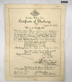 Bendigo Military Museum
Certificate - DISCHARGE CERTIFICATE WW2, 8.12.1944
William Graham GOODMAN VX11397 enlisted in the 2nd AIF on 27.3.1940 age 33 years 2 months. 8.4.1940 posted to 2/5th Batt. 14.4.1940 embarked for the Middle East. 22.5.1940 hospitalised with Otitis Media (ear infection). Rejoined unit 27.5 1940. 14.6.1940 hospitalised with a throat infection. Rejoined unit 16.6.1940. 27.7.1940 transferred to 6th Division ASC. From here he served in Ammunition and Composite Coy’s in 6th Div ASC and graded Group 2 Mechanic MT. 24.3.1941 embarked for Greece. 5.6.1941 reported as missing. 15.12.1941 officially reported as POW in Stalag V111B. 17.5.1944 as part of a POW exchange he embarked from Barcelona to Algiers then Alexandria arriving on 2.6.1944. He is admitted to No 5 NZ GH with Dyspepsia and discharged on 9.6.1944. 28.8.1944 embarked for Australia as a medical casualty. 29.9.1944 arrived Sydney. Hospital again with Dysentry and is medically down graded to D. 6.12.1944 marched out to GDD for discharge. 18.2.1945 discharged from the Army. A document in his records that he supplied details states his POW No 24198. He was captured on 1.6.1941 on Crete and they were on rear guard action at their post when the Island capitulated. It also details living conditions, clothing issue, food, sanitary, treatment, parcels etc. Ref Reg No's 3768, 3569, 3570, 3571, 3572, 3573. A4 certificate, yellowed, folded 8 times. Certificate of Discharge for VX11397 William Graham GOODMAN, Certificate No 151615. AIF Royal Park 8.12.1944.certificate, discharge, aif -
 Eltham District Historical Society Inc
Document, 14 Stokes Place, Eltham: Building plans and contracts, 1979c
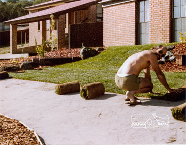
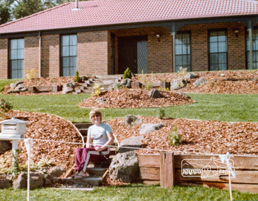
14 Stokes Place was the home of Peter and Carla Vermey. The land was purchased in May 1979 and the home built by Peter and Carla Vermey after the developer, Macquarie Builders went bankrupt. Sold October 2017 by Morrison and Kleeman Real Estate. Stokes Place was part of the Stokes Orchard Estate which was developed from the break-up of the the orchard owned by Frank Stokes who lived on the northeast corner of Nyora Road and Eucalyptus Road. His daughter Beryl advised that the Shire had levied a rate assessment on individual parcels of land within the orchard which became unaffordable resulting in its sub-division and sell off. The Stokes Orchard Estate was developed by Macquarie Builders in two stages starting with stage 1 in 1976. Stokes Place was part of Stage 2 in 1979. The Estate was bounded between Nyora Road, Eucalyptus Road, Diosma Road and Stokes Place. The original orchard only just reached the left most portions of Stokes Place and did not go fully up to Diosma, rather to just beyond the extant of Stokes Place. Stokes Place was known within the family as "The Oats" as that is where they grew oats. Frank Stokes moved to Eltham c.1945 after visiting Harold Bird to view his orchard, located diagonally opposite Stokes Orchard from the intersection of Eucalyptus Road, Pitt Street and Nyora Road. It was on Harold Bird's recommendation that Frank purchased the land.The Stokes Orchard Estate collection is typical of housing developments of the late 1970s and 1980s. It was one of the earliest estates in Eltham following the nearby Woodridge Estate development.Digital file30 digital files scanned from documents provided on loan by Peter and Carla Vermeystokes place, eltham, stokes orchard, stokes orchard estate, streets, houses, peter and carla vermey -
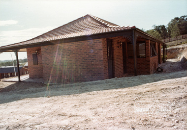
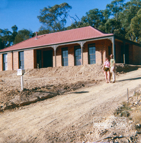 Eltham District Historical Society Inc
Photograph, 14 Stokes Place, Eltham, April 1980, 1980
14 Stokes Place was the home of Peter and Carla Vermey. The land was purchased in May 1979 and the home built by Peter and Carla Vermey after the developer, Macquarie Builders went bankrupt. Sold October 2017 by Morrison and Kleeman Real Estate. Stokes Place was part of the Stokes Orchard Estate which was developed from the break-up of the the orchard owned by Frank Stokes who lived on the northeast corner of Nyora Road and Eucalyptus Road. His daughter Beryl advised that the Shire had levied a rate assessment on individual parcels of land within the orchard which became unaffordable resulting in its sub-division and sell off. The Stokes Orchard Estate was developed by Macquarie Builders in two stages starting with stage 1 in 1976. Stokes Place was part of Stage 2 in 1979. The Estate was bounded between Nyora Road, Eucalyptus Road, Diosma Road and Stokes Place. The original orchard only just reached the left most portions of Stokes Place and did not go fully up to Diosma, rather to just beyond the extant of Stokes Place. Stokes Place was known within the family as "The Oats" as that is where they grew oats. Frank Stokes moved to Eltham c.1945 after visiting Harold Bird to view his orchard, located diagonally opposite Stokes Orchard from the intersection of Eucalyptus Road, Pitt Street and Nyora Road. It was on Harold Bird's recommendation that Frank purchased the land.The Stokes Orchard Estate collection is typical of housing developments of the late 1970s and 1980s. It was one of the earliest estates in Eltham following the nearby Woodridge Estate development.Digital fileScanned from a print contained in owner's photo album (81 prints in total digitised)stokes place, eltham, stokes orchard, stokes orchard estate, streets, houses, peter and carla vermey -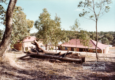
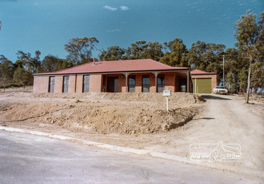
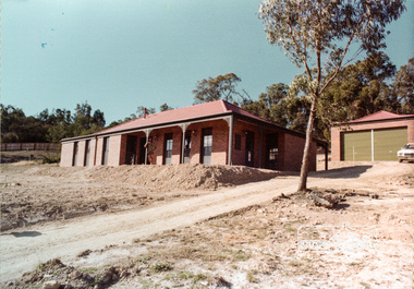
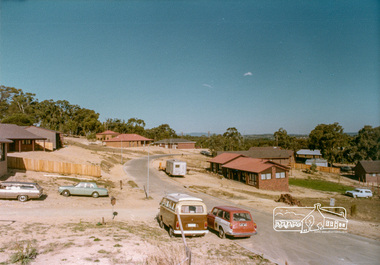 Eltham District Historical Society Inc
Photograph, Stokes Place, Eltham, April 1980; viewed from near no. 10 looking southeast, 1980
14 Stokes Place was the home of Peter and Carla Vermey. The land was purchased in May 1979 and the home built by Peter and Carla Vermey after the developer, Macquarie Builders went bankrupt. Sold October 2017 by Morrison and Kleeman Real Estate. Stokes Place was part of the Stokes Orchard Estate which was developed from the break-up of the the orchard owned by Frank Stokes who lived on the northeast corner of Nyora Road and Eucalyptus Road. His daughter Beryl advised that the Shire had levied a rate assessment on individual parcels of land within the orchard which became unaffordable resulting in its sub-division and sell off. The Stokes Orchard Estate was developed by Macquarie Builders in two stages starting with stage 1 in 1976. Stokes Place was part of Stage 2 in 1979. The Estate was bounded between Nyora Road, Eucalyptus Road, Diosma Road and Stokes Place. The original orchard only just reached the left most portions of Stokes Place and did not go fully up to Diosma, rather to just beyond the extant of Stokes Place. Stokes Place was known within the family as "The Oats" as that is where they grew oats. Frank Stokes moved to Eltham c.1945 after visiting Harold Bird to view his orchard, located diagonally opposite Stokes Orchard from the intersection of Eucalyptus Road, Pitt Street and Nyora Road. It was on Harold Bird's recommendation that Frank purchased the land.The Stokes Orchard Estate collection is typical of housing developments of the late 1970s and 1980s. It was one of the earliest estates in Eltham following the nearby Woodridge Estate development.Digital fileScanned from a print contained in owner's photo album (81 prints in total digitised)stokes place, eltham, stokes orchard, stokes orchard estate, streets, houses, peter and carla vermey -
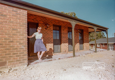 Eltham District Historical Society Inc
Photograph, 14 Stokes Place, Eltham, April 1980, 1980
14 Stokes Place was the home of Peter and Carla Vermey. The land was purchased in May 1979 and the home built by Peter and Carla Vermey after the developer, Macquarie Builders went bankrupt. Sold October 2017 by Morrison and Kleeman Real Estate. Stokes Place was part of the Stokes Orchard Estate which was developed from the break-up of the the orchard owned by Frank Stokes who lived on the northeast corner of Nyora Road and Eucalyptus Road. His daughter Beryl advised that the Shire had levied a rate assessment on individual parcels of land within the orchard which became unaffordable resulting in its sub-division and sell off. The Stokes Orchard Estate was developed by Macquarie Builders in two stages starting with stage 1 in 1976. Stokes Place was part of Stage 2 in 1979. The Estate was bounded between Nyora Road, Eucalyptus Road, Diosma Road and Stokes Place. The original orchard only just reached the left most portions of Stokes Place and did not go fully up to Diosma, rather to just beyond the extant of Stokes Place. Stokes Place was known within the family as "The Oats" as that is where they grew oats. Frank Stokes moved to Eltham c.1945 after visiting Harold Bird to view his orchard, located diagonally opposite Stokes Orchard from the intersection of Eucalyptus Road, Pitt Street and Nyora Road. It was on Harold Bird's recommendation that Frank purchased the land.The Stokes Orchard Estate collection is typical of housing developments of the late 1970s and 1980s. It was one of the earliest estates in Eltham following the nearby Woodridge Estate development.Digital fileScanned from a print contained in owner's photo album (81 prints in total digitised)stokes place, eltham, stokes orchard, stokes orchard estate, streets, houses, peter and carla vermey -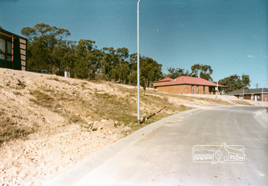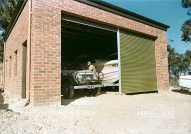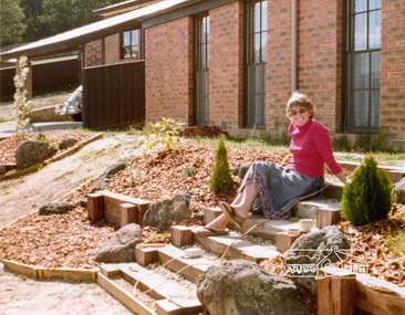
 Eltham District Historical Society Inc
Photograph, 14 Stokes Place, Eltham, April 1980, 1980
14 Stokes Place was the home of Peter and Carla Vermey. The land was purchased in May 1979 and the home built by Peter and Carla Vermey after the developer, Macquarie Builders went bankrupt. Sold October 2017 by Morrison and Kleeman Real Estate. Stokes Place was part of the Stokes Orchard Estate which was developed from the break-up of the the orchard owned by Frank Stokes who lived on the northeast corner of Nyora Road and Eucalyptus Road. His daughter Beryl advised that the Shire had levied a rate assessment on individual parcels of land within the orchard which became unaffordable resulting in its sub-division and sell off. The Stokes Orchard Estate was developed by Macquarie Builders in two stages starting with stage 1 in 1976. Stokes Place was part of Stage 2 in 1979. The Estate was bounded between Nyora Road, Eucalyptus Road, Diosma Road and Stokes Place. The original orchard only just reached the left most portions of Stokes Place and did not go fully up to Diosma, rather to just beyond the extant of Stokes Place. Stokes Place was known within the family as "The Oats" as that is where they grew oats. Frank Stokes moved to Eltham c.1945 after visiting Harold Bird to view his orchard, located diagonally opposite Stokes Orchard from the intersection of Eucalyptus Road, Pitt Street and Nyora Road. It was on Harold Bird's recommendation that Frank purchased the land.The Stokes Orchard Estate collection is typical of housing developments of the late 1970s and 1980s. It was one of the earliest estates in Eltham following the nearby Woodridge Estate development.Digital fileScanned from a print contained in owner's photo album (81 prints in total digitised)stokes place, eltham, stokes orchard, stokes orchard estate, streets, houses, peter and carla vermey