Showing 12310 items
matching railway
-
 Melton City Libraries
Photograph, Melton Railway Bridge, c.1884
"The Melton Viaduct, opened in 1886, is of State heritage significance as a very large and visually distinctive wrought iron, lattice girder trestle bridge over the Werribee River (now Melton Reservoir). It comprises 18.3 and 9.1 metre spans, in a generally alternate arrangement, of total length 375 metres, and standing 38 metres over the Werribee River. Wrought iron small section iron was used to build tension trussed trestle legs, which supported four lines of rivetted wrought-iron deck-type double lattice trusses. It has bluestone abutments and pier bases of coursed rock-faced bluestone with drafted margins. The larger half-piers, now usually submerged in the Melton Reservoir have sharp tapered cutwaters and curved coping at the tops. While designed to carry two rail tracks it has only ever been used as a single track line. Despite several alterations to its deck structure, it remains an outstanding example of a lighter structural design employing open metal trestle supports and metal truss girders. The direct Melbourne to Ballarat railway link of which the Melton viaduct was the major engineering work contributed significantly to the history and development of Victoria. This new link reflected Ballarat’s diversifying economy as well as the commercial and political influence of the metropolis. Construction of the bridge, and the associated large workers camp, were extensively photographed, documenting an important episode in local history. The railway enabled the development of new industries in the Melton area, notably the timber industry and a chaff industry of national importance, greatly facilitated the later transition of the Shire from a pastoral to a farming economy, and struck a major blow to Melton township’s era as a wayside town servicing Ballarat road (especially coach) traffic". Melton Railway Bridge being built across the Werribee Rivertransport -
 Eltham District Historical Society Inc
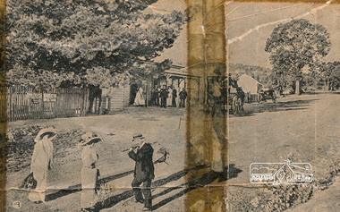
Newspaper clipping, 4. The mail coach leaving for Kangaroo Ground.; New Railway Line: Eltham to Hurst's Bridge; The Weekly Times, 24 Feb 1912, p27, 1912
Pages from a scrapbook belonging to Heather Jenkins (nee Sargeant) who lived as a child in the Police Residence at 728 Main Road, Eltham in the 1920s. Images featured are 1. A peep on the road, nearing Research. 2. The Main Road at Eltham (opposite Railway Station). 3. A part of the new railway line. 4. The mail coach leaving for Kangaroo Ground.Heather Sargeant was the daughter of Constable W.C. Sargeant, the local police officer in residence at Eltham, 1922-1927Detail from large newspaper clipping (half page), very aged and fragile with sticky tape holding it together with 4 images of early Elthameltham, heather jenkins (nee sargeant), railway, railway line, mail coach, eltham railway station -
 Ringwood and District Historical Society
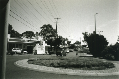
Photograph-B&W, Joan Walker, East Ringwood 2000- Roundabout in Railway Avenue cnr Wenwood Street looking West (railway line on right hand side), 2000
East Ringwood 2000- Roundabout in Railway Avenue cnr Wenwood Street looking West (railway line on right hand side)- B&W Photo from Album 6501 -
 Greensborough Historical Society
Newspaper Clipping, Eltham Railway: loan, deviation and compensation, 21/05/1900
Relates to the disagreement between advocates of the original surveyed route and the proposed "deviation" for the Heidelberg to Eltham railway extension, 1900.6 p. transcripts of newspaper reports from the Age 21/05/1900 and Mercury and Weekly Courier 13/07/1900 regarding discussions on the route to be taken by the Heidelberg to Eltham railway extensionrailways, hurstbridge rail line -
 Otway Districts Historical Society
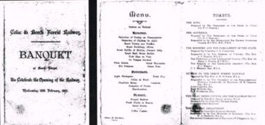
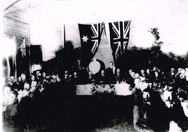
Photograph, Banquet, Opening of Colac-Beech Forest Railway, 1902, 26 Feb 1902
The official opening of the Colac-Beech Forest railway took place on Wednesday, 26th February, 1902. On a typical Beech Forest wet day the train halted at the bottom of Gardner Hill for the opening party led by the State Governor, Sir George Sydenham Clarke, to walk up to the Ditchley Park Hotel for the official banquet in the adjoining hall. The menu of four courses plus coffee was assembed by the caterer, Chas. D. Straker. The toast list was led as usual by a toast to the King, followed by 18 toasts concluded by the Acting Commissioner of Railways.B/W. The menu and toast list at the opening of the Colac-Beech Forest Railway on Wednesday, 26th February, 1902, at Beech Forest. 128mm x 264mm actual -
 Stawell Historical Society Inc
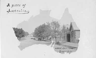
Postcard, Railway Hotel in Lower Main Street Stawell c1900 -- Postcard
Postcard with Australia outline Wooden Railway Hotel Lower Main Street Stawell c1900 with Cattle on roadway near rail crossing. By the "Merle Studio" Main Street Stawell.Postcard with Australia outline Wooden Railway Hotel Lower Main Street Stawell c1900 with Cattle on roadway near rail crossing. By the "Merle Studio" Main Street Stawell.stawell -
 Wodonga & District Historical Society Inc
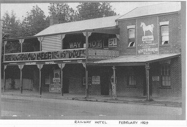
Photograph - Murray River "Railway" Hotel, Wodonga
Located in High Street, Wodonga, this hotel underwent many modifications and name changes. It was built c1859 by James Bambrick close to the intended rail terminal in Huon Street. The site of the rail terminal actually changed but the name remained. James Bambrick served three terms as Wodonga Council president and was it was commonly referred to as “Bambrick’s Hotel”. It included 30 rooms as well as dining facilities. James Bambrick ran the hotel until 1902 when it was sold to J. Donnelly for £3,000. In 1912, whilst operated by T. J. Weller, the residential section of the hotel was almost completely destroyed by fire but only the ceiling of the bar was damaged and it continued to operate. Over the ensuing years the licensee changed hands frequently. By 1952, John Perry, owner of the “Stump” Junction Hotel also had the freehold of the Railway Hotel At some stage in the mid 1980’s the hotel was renamed as the “Murray River Hotel”, but still displayed the sign of the Railway Hotel. In 2009, it was closed for a short time whilst renovations took place to convert it into O’Maille’s Irish Hotel. It was demolished in 2020. These images document changes to an important local building first established c1868. It was an important meeting place and also the location of the earliest Council meetings in Wodonga.A set of photos both black and white and colour depicting changes to the Railway Hotel, Wodonga over timeA variety of names and advertising signsjames bambrick wodonga, bambrick's hotel, railway hotel wodonga, murray river hotel wodonga, o'maille's hotel, -
 Stawell Historical Society Inc
Map, Rupunyup and Marnoo Railway Construction District 1900, 11/06/1908
Map Shows Rail Lines. Glenorchy Lubeck Rupunyup Marnoo Murtoa MinyipMap Showing line to be Constructed from Rupunyup to Newall's Corner Marnoo.Marnoo Railway Trustrailways -
 Kiewa Valley Historical Society
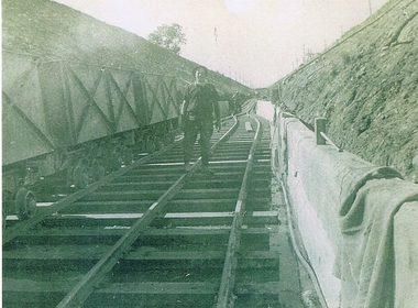
Photograph KHS Rail, Kiewa Hydroelectric Scheme Railway, Circa1940s
This photograph shows part of the railway constructed and used for the removal of soil and rocks from the tunnels bored out of the mountains for the pipeline servicing the Hydro Electricity power stations in the Kiewa Hydroelectric Scheme. This photo details an era when there were 4,000 construction workers located in two main accommodation camps, Mount Beauty (the larger one) and Bogong village. These accommodation sites were constructed and maintained as a secured or gated residential area with access only available by a special pass authorised by the Kiewa Hydroelectric Scheme. All the power used by the rail system was from electric motors connected to batteries. Overhead power poles seen on either side of the embankment details that electricity from the Scheme was in use. This use was cleaner and more environmentally friendly than the coal still used by large locomotives from city to country railways. The worker shown is not however wearing protective head and hand coverings. This is also an era where there was a lack of health and safety legislation covering workers in dangerous working conditions.Scanned photo of original black and white photo on Kodak XtraLife II paper. Picture is of a section of railway track servicing the tunnels of the Hydroelectric scheme during the 1940s - 1950sOn back of photo "Kodak XtraLife II paper"railway in kiewa electric scheme, tunneling -
 Otway Districts Historical Society
Photograph, Doug McLean, Gellibrand: Kanyana Special to Beech Forest, 1 March 1959
On the 1st March, 1959, the first special train was organized by the Australian Railways Historical Society in conjunction with the Kanyana Festival Committee of Colac, Victoria. It proved so popular that additional trains were later organized. Temporarily in storage at Newport railway yards eight NBH excursion carriages were transferred to Colac which ran on the special trains until early-1962. A A.R.H.S. "Kanyana" special excursion locomotive G41, an NC guard's van and NBH excursion carriages at halts at Gellibrand while the fireman attends to the engine requirements (or 'ER' in railways' parlance). The passengers are milling outside the excursion carriages while two are talking to the driver. Houses are in the background. B/W.gellibrand; railways; kanyana special; colac; beech forest; loco g41; -
 Stawell Historical Society Inc
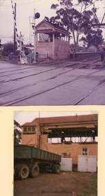
Photograph, Railway Signal Box No.1 being Demolished in Seaby Street- 2 Photos -- Coloured
Railway Signal Box No1 under Demolition situated by boom gates Seaby Street Stawell.Another two coloured views of the Railway signal box being demolished. One a close up with windows removed. The other a distant view with a brick building in front of the signal box and 2 people in front of the brick building. stawell -
 Kew Historical Society Inc
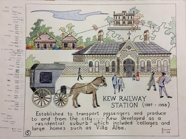
Work on paper, Joy Stewart, 5. Kew Railway Station (1887-1958), 1988
Kew Tapestry The eight panels depict the history of Kew. This was a 1988 Australian Bi-Centennial Project carried out under the auspices of City of Kew Council and the Kew Historical Society Incorporated. Nearly 600 citizens including many children participated in the production by adding a few or more stitches. A book records their names and the panels upon which they worked. Artist: Joy Stewart Co-ordinator: Dorothy BenyeiSydney Joy (Joy) Stewart was born in Melbourne 1925. She studied at Swinburne Technical College Art School from 1941-1945, then the National Gallery Art School 1946-1948. Her career included employment positions as a display artist, designer/painter, gallery assistant, and art teacher. Joy relocated to Cairns in 1981. Solo exhibitions in Melbourne and Cairns, including 'Done By Me' at Cairns Regional Gallery in 1999. Group exhibitions at Cairns Regional Gallery, 'The Fish John West Regrets, 1993' and 'Facets of Life' 1994. Joy Stewart died in Cairns in 2018.5. Kew Railway Station (1887-1958). A Handcoloured cartoon created by the artist Joy Stewart as a template for the fifth of a series of embroidered panels depicting the history of Kew. Wool colour codes at left. Inscription: "KEW RAILWAY STATION (1887-1958). Established to transport passengers and produce too and from the city ... Kew developed as a residential suburb which included cottages an dlarge homes such as Villa Alba". Signed by the artist "(c) JStewart, 1988"bicentennial project (kew), joy stewart -
 Melbourne Tram Museum
Document - Report, The Parliamentary Standing Committee on Railways, "Report - Darling - Glen Waverley" and Outer Eastern Suburbs Connecting Railway, "Proposed Kew to Doncaster Electric Railway Extension", "Keilor and Bulla Districts Connecting Railway", "Proposed Expenditure under railway loan application Act - provision of connecting lines between Glenroy and Albion and Melbourne Goods Yard", 1923
Set of six reports from the "The Parliamentary Standing Committee on Railways" .1 - Report - 12 pages + plan printed stapled titled "Report - Darling - Glen Waverley" - includes connexion between Camberwell to Ferntree Gully and Oakleigh. Dated 30/6/1926 .2 - Report - 16 pages - "Report - Outer Eastern Suburbs Connecting Railway or Tramway (Doncaster, Templestowe and Warrandyte)"- 8/7/1925. .3 - Report - 24 pages - "Doncaster and Warrandyte Districts Connecting Railway" - 13/12/1928 - 2 copies held. .4 - Report - 12 pages - Proposed Kew to Doncaster Electric Railway Extension" - 4/12/1930 - 3 copies held - see also Reg Item 414. .5 - Report - 16 pages including plan - "Keilor and Bulla Districts Connecting Railway" - 1926. .6 - Progress Report - 12 pages including plans - "Proposed Expenditure under railway loan application Act - provision of connecting lines between Glenroy and Albion and Melbourne Goods Yard" - 30/6/1926. Includes a circular letter dated 24/7/1926, enclosing reports 5 and 6 from the Secretary of the Metropolitan Town Planning Commission. Note: All these documents are available as a pdf on the Parliament of Victoria website..2 - has "Manager" stamped and "Mr. Murdoch" and a date in the top right hand corner.. .3 - copy 2 - has "Mr. Lormer" as for .4trams, tramways, railways, parliament, darling, glen waverley, doncaster, templestowe, warrandyte, keilor, essendon -
 Stawell Historical Society Inc
Photograph, Railway Station Stawell used as a Bus Station 1995 --2 Photos -- Coloured
Two colour photographs Stawell Railway Station when used as Bus Station Feb 1995Two Colour Photographs of the Stawell Railway Stationone with the station in the distance, the other from th efront of the sttion with a sign reading Stawell Bus Station other signs visable but unclear there is a red flag hanging from one of the verandah ploes.Stawell Bus Stationstawell railways transport -
 City of Kingston
Pamphlet - Colour, Duffus Bros, Railway Reserve Highett, c. 1923
Sales plan for land in the suburb of Highett, titled Railway Reserve, incorporating properties along Wolseley Street, Livingston Street, Highett Road and Worthing Road. The developing urban area of Highett within the City of Kingston. This land sale pamphlet illustrates the subdivision of land within the municipality and the changing demographic of the district as new houses and shops are constructed close to infrastructure.Colour pamphlet advertising thirty eight shop and villa sites for sale at the Railway Reserve, Highett. Incorporates a map of the reserve with properties available on Wolseley Street, Livingston Street, Highett Road and Worthing Road. Handwritten in grey pencil: assumed sale price recorded on subdivisions 1-7, 10, 22, 23 and 34 Handwritten in grey pencil on subdivision 4: C. Nevill / City of Melbourne bank Handwritten in grey pencil across subdivision 7: 49' Handwritten in grey pencil across subdivision 21 and 22: 134' Handwritten in grey pencil across subdivision 25 and 26: 200' Handwritten in grey pencil across subdivision 36 and 37 and both top and bottom: 120' Hand drawn in blue pencil: outline of subdivision 4 Hand drawn in blue pencil: outline of subdivisions 7, 23, 28, 37, 38 along left hand side, subdivisions 38, 37 and 36 on Wolseley Street, subdivisions 30 and 29 along Wolseley Street, subdivisions 29 and 24 along the middle of the plan, subdivisions 24 and half of 25 along Livingston Street, half of subdivision 20 along the middle of the plan, subdivisions 21 and 22 along the Right of Way between Livingston Street and Highett Road, and along the right hand border of subdivision 7. Handwritten in ink adjacent to the subdivision plan, updside down, in the bottom right hand corner: 276 / 54 / 280 / 45 / 320 / 202 / 200 / 134 / horizontal line / 11/14 Handwritten in ink adjacent to the subdivision plan, updside down, in the bottom right hand corner: 1714)2200(15 / 1714 / horizontal line / 486land sales, highett -
 Wycheproof & District Historical Society Inc.
Railway Book, Wycheproof Railway, 2004
Friday, September 28, 1883 was a memorable date for Wycheproof as on that day was the long-awaited official opening of the railway. It was recorded that no less than 23 parishes would act as feeder to the rail line. The Railway Station closed in December 1990 but the building was renovated in 2010 with plans for a community focus and cultural events.The arrival of rail opened up the Mallee. Local farmers began sending wheat, sheep and wool by rail. Improvements to transport stock was ongoing and the eventual rail extension north of the town, resulted in a well patronised passenger service for years. Railway families and workers added to the culture of the town.Display Book of A3 size with 20 pockets of Wycheproof Rail information. It includes a collection of newspaper and magazine articles, photos, rail drawings, train calendar, paint colour legend and other rail references.sea lake, railway, rail-drawing, last-passenger- train, centenary- train, train - calendar, steaming- up- broadway, wycheproof - rail -
 Orbost & District Historical Society
magazines, Atlas Press Pty Ltd, East Gippsland & Railway Extension, 10 September 1908
Orbost and East Gippsland Railway League had proposed a railway extension through East Gippsland in 1908, which aimed to develop an isolated part of the country. At the time, construction of a railway could be considered a beneficial investment for the country as it could increase the population in the region. The proposed railway length in 1908 was about 140 miles and the cost was estimated £800,000. The line was proposed to proceed from Bairnsdale by way of the Lower Nicholson to Bruthen. “After crossing the Tambo River, it would be carried to near Nowa Nowa; the head of Lake Tyers, forward to Orbost. From Orbost it would proceed in a north-easterly way to the New South Wales border. There were different suggested routes between Orbost and the New South Wales border, the first was through Bendoc, another by the Cann River and another which is located between these two. This item is associated with the history of the Orbost-Bairnsdale railway line and therefore reflects the role that the rail line played in the social and economic history of Orbost. The Bairnsdale-Orbost railway was opened in 1916 to serve the agricultural and timber industry. Because of the decline in traffic and heavy operating costs, the line was finally closed in August, 1987. Two small magazines showing the railway extension through East Gippsland. 678.1 has a dark maroon cover with gold print writing. It contains b/w photographs. 678.2 has a red cover with black print writing. Both are bound. 678.1 - inside front cover - M. Beattie ???????? Newmerella 678.2 - inside front cover - Gordon Fisher Orbosteast-gippsland-railway-league railway -
 Orbost & District Historical Society
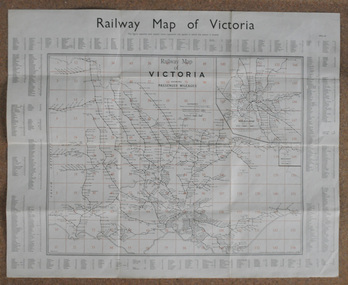
map, Railway Map of Victoria, 1.8.1965
The Bairnsdale-Orbost railway was opened in 1916 to serve the agricultural and timber industry. Because of the decline in traffic and heavy operating costs, the line was finally closed in August, 1987.This item is associated with the history of the Orbost-Bairnsdale railway line and therefore reflects the role that the rail line played in the social and economic history of Orbost.A large rectangular shaped paper map of all railway stations in Victoria. It is dated 1st August 1965. It is divided into grids. Stations are listed around the map. A key is provided and each station has a grid reference.map-railway victorian-railways -
 Stawell Historical Society Inc
Photograph, Railway Signal Box No.1 being Demolished in Seaby Street -- 2 Photos -- Coloured
Railway Signal Box No1 under Demolition situated by boom gates Seaby Street.Two coloured photographs of the railway signal box being demolished. The photo shows men working beside and on the building. A large tree can be seen in the background. The second photo shows a large trailer parked around the other side of the rail line and signal box. stawell -
Whitehorse Historical Society Inc.
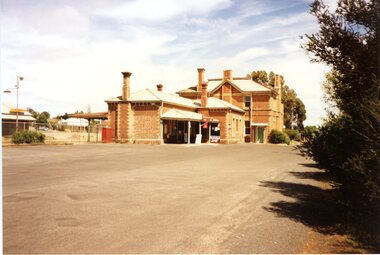
Photograph - Illustration, Mitcham Railway Station
Photos of Mitcham Railway Station in 1966 and 1975, from Australian Railway Enthusiast.Photos of Mitcham Railway Station in 1966 and 1975, from Australian Railway Enthusiast.Photos of Mitcham Railway Station in 1966 and 1975, from Australian Railway Enthusiast.mitcham railway station, 1966 -
 St Kilda Historical Society
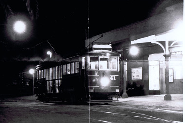
Photograph, Victorian Railway Tram, c. 1950s?
black and white photograph (2 identical, unmounted)St Kilda Railway Station with Victorian Railway Tram. From St Kilda to Brighton Beach. -
 Clunes Museum
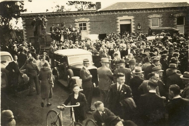
Photograph, 1939
THIS PHOTOGRAPH WAS TAKEN AT CLUNES RAILWAY STATION , CROWD ARRIVING FOR EASTER CENTENARY 1939ORIGINAL PHOTOGRAPH OF CLUNES RAILWAY STATION & CROWD SCENE. EASTER CENTENARY 1939.CLUNES RAILWAY STATION 1939local history, photography, photographs, events and celebrations, back to clunes [railway station] -
 Otway Districts Historical Society
Photograph, Knox Collection, Opening banquet, Colac-Beech Forest railway line, 1902, 27 February 1902
While the first train arrived at Beech Forest on 17 February, 1902, as a special train for a race meeting at Beech Forest Turf Club, two special trains ran for the official opening of the railway by the State Governor, Sir George Sydenham Clarke, KCMG, R.E., F.R.S., that took place on 27 February, 1902. After seeing round the area the guests attended a celebration of the opening at a banquet at Beech Forest. The menu included four impressive courses, coffee and cognac, and included a number of toasts - The King, the Governor, the Minister and the Parliament of the State, Success to the Beech Forest Railway, the Colac Shire Council and the Railway Trust, and the Railway Department, a total of 19 people speaking. The official guests then returned to Colac.B/W. Opening banquet for the Colac-Beech Forest railway line in 1902. The State Governor, Sir George Sydenham Clarke, KCMG, the Premier of Victoria, Hon. A.J. Peacock, MLA, and a number of other important people seated at the top table, with other guests seated to the left and right.beech forest; railways; banquet; colac; -
 Federation University Historical Collection
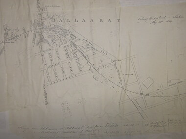
Plan, Ballarat Railway Plan, 1860, 29/05/1860
This plan was created by the Railway Department, Victoria.Photocopy of the Melbourne to Ballarat via Geelong Railway plan. The section is the area adjoining Bakery Hill, Ballarat. The plan shows the Yarrowee River, central Ballarat, Government Camp, Imperial Hotel, Union Hotel, Crown hotel, electric Telegraph line, Eureka Lead, Black Hill Lead, Ballaarat Old Cemetery., Bank of Australasia.ballarat railway, ballarat -
 Surrey Hills Historical Society Collection
Photograph, At Surrey Hills - Railfan tour to Belgrave for the South Pacific Electric Railway Group, 1 October 1966
We have an original copy donated by Iam Barkla and a larger one copied by Ken Hall. The Barkla original has a sticker with his reference details on the back. The occasion was a Railfan tour for the South Pacific Electric Railway Group to Belgrave. Photo taken on 1 October 1966. A black and white photo of an electric train near the Surrey Hills railway station. The shops in Union Road, the pedestrian overpass at the station and houses in Windsor Crescent can be seen in the background.surrey hills railway station, railfan tour, south pacific electric railway group, 1966, union road shops, windsor crescent -
 Bendigo Military Museum
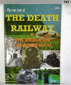
Book, The True Story of the Death Railway & the Bridge on the River Kwai
Book is organised by "J.P".Softcover with collage of photos on cover. Photos are of railway locomotives, a bomber, railway bridges and a soldier.Inside front cover "Donated by Trevor Knight"books, military history -
 Whitehorse Historical Society Inc.
Photograph - Black and white photograph, Railway Parade, Blackburn. 1923, c. 1923
Used by donor in 'Blackburn - a picturesque history'Black & white photo of Railway Parade from Blackburn Railway Station to the Estate 1923.railway parade, blackburn -
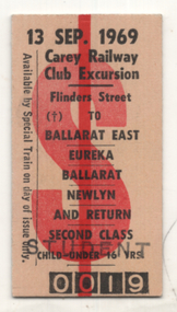 Ballarat Tramway Museum
Ephemera - ticket, Carey Railway Club Excursion, Sept. 1969
Ticket used by a group of Carey Grammar students and friends on 13 Sep. 1969, to Ballarat tour riding the trams, Eureka siding and Newlyn - ticket number 0019.Yields information about a tour by a Carey Grammar group to Ballarat.Edmondson type card railway ticket - printed for Carey Railway Club Excursion 1969stamped "Student" on both sides.tours, carey, ballarat, railways, tramways, eureka -
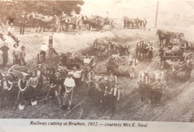 Lakes Entrance Historical Society
Photograph - Railway Cutting Bruthen, Bruthen Victoria, 1912
Sepia toned photograph of workmen with horses and drays working on railway cutting at Bruthen Victoria. Also a black and white photograph of a goods train on bridge at Bruthen 1920 cRailway cutting at Bruthen 1912 - courtesy Mrs E Nealpublic works, railway -
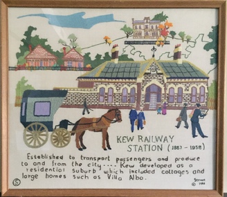 Kew Historical Society Inc
Textile - Bicentennial tapestry, 5. Kew Railway Station (1887-1958), 1988
This is one of eight embroidered panels, completed during the 1988 Australian Bi-Centennial, and carried out under the auspices of City of Kew Council and the Kew Historical Society. Nearly 600 residents, including many children, participated in their production by adding a few or more stitches. A book records their names and the panels upon which they worked. Artist: Joy Stewart / Co-ordinator: Dorothy Benyei.5. Kew Railway Station (1887-1958). A framed embroidery created by adults and children of the City of Kew as a Bicentennial project, based on a design by the artist Joy Stewart. Other completed embroideries created in the project are/were displayed in the Kew Library. Inscription: "KEW RAILWAY STATION (1887-1958). Established to transport passengers and produce too and from the city ... Kew developed as a residential suburb which included cottages and large homes such as Villa Alba". Embroidered signature of the artist "(c) JStewart, 1988"bicentennial project (kew), joy stewart, australian bicentennial, kew railway station