Showing 7613 items matching " road development"
-
 Flagstaff Hill Maritime Museum and Village
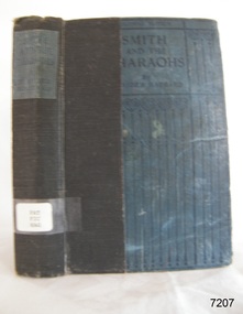
Book - Novel, H Rider Haggard, author, Smith and the Pharaohs and other tales, 1920
H. Rider Haggard (1856-1925) (Sir H. Rider Haggard), was a British author of fiction and non-fiction works and had letters and articles published in newspapers and journals. The page opposite the book's Fly page lists some of the topics Rider Haggard covered; Parliamentary Blue Book, political history, works on agriculture, country life, social history, travel, novels and romances. This edition of the book was published for Laurie's Colonial Library by the firm T. Werner Laurie Limited of London. It was made specifically for the British Colonies and India. This book is part of Flagstaff Hill's Pattison Collection.This edition of the book was published by T Werner Laurie as part of Laurie's Colonial Library, books destined only for the British Colonies and India, The book has additional importance for its connection to the Pattison Collection, which, along with other items at Flagstaff Hill Maritime Village, was originally part of the Warrnambool Mechanics' Institutes’ Collection. The Warrnambool Mechanics’ Institute book collection has historical and social significance for its strong association with the Mechanics Institute movement and its important role in people's intellectual, cultural and social development throughout the latter part of the nineteenth century and the early twentieth century. The collection of books is a rare example of an early lending library and its significance is enhanced by the survival of an original collection of many volumes. The Warrnambool Mechanics' Institute’s publication collection is of both local and state significance.Smith and the Pharaohs and other tales Author: H Rider Haggard Publisher: T Werner Laurie Ltd Date: 1st published 1920 Inscriptions include a label, stickers, stamp and a handwritten inscription. This book is part of the Pattison Collection.Label: "PAT FIC HAG" Sticker: "Warrnambool Mechanics Institute and Free Library" covered by a sticker"Corangamite Regional Library Service" Stamp: "Warrnambool Mechanics Institute" Handwritten: "1301" Fly page note: "COPYRIGHT EDITION / ALL RIGHTS RESERVED / This Edition is issued for sale and circulation in the British Colonies and India, and must not be imported into the Continent of Europe or the United States of America." flagstaff hill, flagstaff hill maritime museum and village, warrnambool, maritime museum, maritime village, great ocean road, shipwreck coast, pattison collection, ralph eric pattison, warrnambool mechanics’ institute, mechanics’ institute library, warrnambool library, free library, corangamite regional library service, smith and the pharaohs and other tales, smith and the pharohs, h rider haggard, sir h rider haggard, t werner laurie ltd, laurie's colonial library, british colonial books, 1950 -
 Flagstaff Hill Maritime Museum and Village
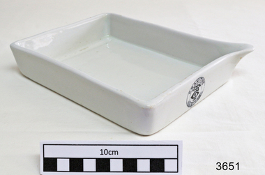
Functional object - Developing Tray, Early 20th century
This was the earliest system of developing photographs, and was still in use well into the 20th century. The negative was placed in a dish with the developing solution, the photographer judged when development was complete by holding the plate to a safelight. To compensate for wrong exposure or lack of contrast it was normal, at the time, for the constituents of the developer to be altered during development, based on how the image was appearing. This developing tray or dish was used for developing film plates or rolls of film. The tray was donated to Flagstaff Hill Maritime Village by the family of Doctor William Roy Angus, Surgeon and Oculist. It is part of the “W.R. Angus Collection” that includes historical medical equipment, surgical instruments and material once belonging to Dr Edward Ryan and Dr Thomas Francis Ryan, (both of Nhill, Victoria) as well as Dr Angus’ own belongings. It was probably used by Dr. T. F. Ryan in conjunction with his state-of-the-art X-Ray machine. The Collection’s history spans the medical practices of the two Doctors Ryan, from 1885-1926 plus that of Dr Angus, up until 1969. ABOUT THE “W.R.ANGUS COLLECTION” Doctor William Roy Angus M.B., B.S., Adel., 1923, F.R.C.S. Edin.,1928 (also known as Dr Roy Angus) was born in Murrumbeena, Victoria in 1901 and lived until 1970. He qualified as a doctor in 1923 at University of Adelaide, was Resident Medical Officer at the Royal Adelaide Hospital in 1924 and for a period was house surgeon to Sir (then Mr.) Henry Simpson Newland. Dr Angus was briefly an Assistant to Dr Riddell of Kapunda, then commenced private practice at Curramulka, Yorke Peninsula, SA, where he was physician, surgeon and chemist. In 1926, he was appointed as new Medical Assistant to Dr Thomas Francis Ryan (T.F. Ryan, or Tom), in Nhill, Victoria, where his experiences included radiology and pharmacy. In 1927 he was Acting House Surgeon in Dr Tom Ryan’s absence. Dr Angus had become engaged to Gladys Forsyth and they decided he would take time to further his studies overseas in the UK in 1927. He studied at London University College Hospital and at Edinburgh Royal Infirmary and in 1928, was awarded FRCS (Fellow from the Royal College of Surgeons), Edinburgh. He worked his passage back to Australia as a Ship’s Surgeon on the on the Australian Commonwealth Line’s T.S.S. Largs Bay. Dr Angus married Gladys in 1929, in Ballarat. (They went on to have one son (Graham 1932, born in SA) and two daughters (Helen (died 12/07/1996) and Berenice (Berry), both born at Mira, Nhill ) Dr Angus was a ‘flying doctor’ for the A.I.M. (Australian Inland Ministry) Aerial Medical Service in 1928 . The organisation began in South Australia through the Presbyterian Church in that year, with its first station being in the remote town of Oodnadatta, where Dr Angus was stationed. He was locum tenens there on North-South Railway at 21 Mile Camp. He took up this ‘flying doctor’ position in response to a call from Dr John Flynn; the organisation was later known as the Flying Doctor Service, then the Royal Flying Doctor Service. A lot of his work during this time involved dental surgery also. Between 1928-1932 he was surgeon at the Curramulka Hospital, Yorke Peninsula, South Australia. In 1933 Dr Angus returned to Nhill where he’d previously worked as Medical Assistant and purchased a share of the Nelson Street practice and Mira hospital from Dr Les Middleton one of the Middleton Brothers, the current owners of what was once Dr Tom Ryan’s practice. Dr L Middleton was House Surgeon to the Nhill Hospital 1926-1933, when he resigned. [Dr Tom Ryan’s practice had originally belonged to his older brother Dr Edward Ryan, who came to Nhill in 1885. Dr Edward saw patients at his rooms, firstly in Victoria Street and in 1886 in Nelson Street, until 1901. The Nelson Street practice also had a 2 bed ward, called Mira Private Hospital ). Dr Edward Ryan was House Surgeon at the Nhill Hospital 1884-1902 . He also had occasions where he successfully performed veterinary surgery for the local farmers too. Dr Tom Ryan then purchased the practice from his brother in 1901. Both Dr Edward and Dr Tom Ryan work as surgeons included eye surgery. Dr Tom Ryan performed many of his operations in the Mira private hospital on his premises. He too was House Surgeon at the Nhill Hospital 1902-1926. Dr Tom Ryan had one of the only two pieces of radiology equipment in Victoria during his practicing years – The Royal Melbourne Hospital had the other one. Over the years Dr Tom Ryan gradually set up what was effectively a training school for country general-practitioner-surgeons. Each patient was carefully examined, including using the X-ray machine, and any surgery was discussed and planned with Dr Ryan’s assistants several days in advance. Dr Angus gained experience in using the X-ray machine there during his time as assistant to Dr Ryan. Dr Tom Ryan moved from Nhill in 1926. He became a Fellow of the Royal Australasian College of Surgeons in 1927, soon after its formation, a rare accolade for a doctor outside any of the major cities. He remained a bachelor and died suddenly on 7th Dec 1955, aged 91, at his home in Ararat. Scholarships and prizes are still awarded to medical students in the honour of Dr T.F. Ryan and his father, Dr Michael Ryan, and brother, John Patrick Ryan. ] When Dr Angus bought into the Nelson Street premises in Nhill he was also appointed as the Nhill Hospital’s Honorary House Surgeon 1933-1938. His practitioner’s plate from his Nhill surgery states “HOURS Daily, except Tuesdays, Fridays and Saturday afternoons, 9-10am, 2-4pm, 7-8pm. Sundays by appointment”. This plate is now mounted on the doorway to the Port Medical Office at Flagstaff Hill Maritime Village, Warrnambool. Dr Edward Ryan and Dr Tom Ryan had an extensive collection of historical medical equipment and materials spanning 1884-1926 and when Dr Angus took up practice in their old premises he obtained this collection, a large part of which is now on display at the Port Medical Office at Flagstaff Hill Maritime Village in Warrnambool. During his time in Nhill Dr Angus was involved in the merging of the Mira Hospital and Nhill Public Hospital into one public hospital and the property titles passed on to Nhill Hospital in 1939. In 1939 Dr Angus and his family moved to Warrnambool where he purchased “Birchwood,” the 1852 home and medical practice of Dr John Hunter Henderson, at 214 Koroit Street. (This property was sold in1965 to the State Government and is now the site of the Warrnambool Police Station. ). The Angus family was able to afford gardeners, cooks and maids; their home was a popular place for visiting dignitaries to stay whilst visiting Warrnambool. Dr Angus had his own silk worm farm at home in a Mulberry tree. His young daughter used his centrifuge for spinning the silk. Dr Angus was appointed on a part-time basis as Port Medical Officer (Health Officer) in Warrnambool and held this position until the 1940’s when the government no longer required the service of a Port Medical Officer in Warrnambool; he was thus Warrnambool’s last serving Port Medical Officer. (The duties of a Port Medical Officer were outlined by the Colonial Secretary on 21st June, 1839 under the terms of the Quarantine Act. Masters of immigrant ships arriving in port reported incidents of diseases, illness and death and the Port Medical Officer made a decision on whether the ship required Quarantine and for how long, in this way preventing contagious illness from spreading from new immigrants to the residents already in the colony.) Dr Angus was a member of the Australian Medical Association, for 35 years and surgeon at the Warrnambool Base Hospital 1939-1942, He served as a Surgeon Captain during WWII1942-45, in Ballarat, Victoria, and in Bonegilla, N.S.W., completing his service just before the end of the war due to suffering from a heart attack. During his convalescence he carved an intricate and ‘most artistic’ chess set from the material that dentures were made from. He then studied ophthalmology at the Royal Melbourne Eye and Ear Hospital and created cosmetically superior artificial eyes by pioneering using the intrascleral cartilage. Angus received accolades from the Ophthalmological Society of Australasia for this work. He returned to Warrnambool to commence practice as an ophthalmologist, pioneering in artificial eye improvements. He was Honorary Consultant Ophthalmologist to Warrnambool Base Hospital for 31 years. He made monthly visits to Portland as a visiting surgeon, to perform eye surgery. He represented the Victorian South-West subdivision of the Australian Medical Association as its secretary between 1949 and 1956 and as chairman from 1956 to 1958. In 1968 Dr Angus was elected member of Spain’s Barraquer Institute of Barcelona after his research work in Intrasclearal cartilage grafting, becoming one of the few Australian ophthalmologists to receive this honour, and in the following year presented his final paper on Living Intrasclearal Cartilage Implants at the Inaugural Meeting of the Australian College of Ophthalmologists in Melbourne In his personal life Dr Angus was a Presbyterian and treated Sunday as a Sabbath, a day of rest. He would visit 3 or 4 country patients on a Sunday, taking his children along ‘for the ride’ and to visit with him. Sunday evenings he would play the pianola and sing Scottish songs to his family. One of Dr Angus’ patients was Margaret MacKenzie, author of a book on local shipwrecks that she’d seen as an eye witness from the late 1880’s in Peterborough, Victoria. In the early 1950’s Dr Angus, painted a picture of a shipwreck for the cover jacket of Margaret’s book, Shipwrecks and More Shipwrecks. She was blind in later life and her daughter wrote the actual book for her. Dr Angus and his wife Gladys were very involved in Warrnambool’s society with a strong interest in civic affairs. Their interests included organisations such as Red Cross, Rostrum, Warrnambool and District Historical Society (founding members), Wine and Food Society, Steering Committee for Tertiary Education in Warrnambool, Local National Trust, Good Neighbour Council, Housing Commission Advisory Board, United Services Institute, Legion of Ex-Servicemen, Olympic Pool Committee, Food for Britain Organisation, Warrnambool Hospital, Anti-Cancer Council, Boys’ Club, Charitable Council, National Fitness Council and Air Raid Precautions Group. He was also a member of the Steam Preservation Society and derived much pleasure from a steam traction engine on his farm. He had an interest in people and the community He and his wife Gladys were both involved in the creation of Flagstaff Hill, including the layout of the gardens. After his death (28th March 1970) his family requested his practitioner’s plate, medical instruments and some personal belongings be displayed in the Port Medical Office surgery at Flagstaff Hill Maritime Village, and be called the “W. R. Angus Collection”. The W.R. Angus Collection is significant for still being located at the site it is connected with, Doctor Angus being the last Port Medical Officer in Warrnambool. The collection of medical instruments and other equipment is culturally significant, being an historical example of medicine from late 19th to mid-20th century. Dr Angus assisted Dr Tom Ryan, a pioneer in the use of X-rays and in ocular surgery. Developing Tray, white porcelain tray, dish or tank with pouring lip, part of the W. R. Angus Collection. Maker’s Mark is circle with “GRANITINE” on top and symbol of buckled belt on bottom, letters “T T C” intertwined in centre of ring. Early 20th century. Maker’s Mark is circle with “GRANITINE” on top and symbol of buckled belt on bottom, letters “T T C” intertwined in centre of ring.flagstaff hill, warrnambool, shipwrecked coast, flagstaff hill maritime museum, maritime museum, shipwreck coast, flagstaff hill maritime village, great ocean road, dr w r angus, dr ryan, surgical instrument, t.s.s. largs bay, warrnambool base hospital, nhill base hospital, mira hospital, flying doctor, medical treatment, medical history, developing tray, developing tank, developing dish, photographic equipment, historic photographic equipment, historic medical equipment, spiral loading developing tank -
 Flagstaff Hill Maritime Museum and Village
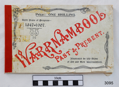
Book, Warrnambool Past & Present, 1907
This is the original book “Warrnambool Past & Present Sixty Years of Progress 1847-1907” that was published in 1907. It features photos of Warrnambool, taken by Edward Vidler in 1907, who matches them with some earlier prints. Vidler had a photographic studio in Liebig Street Warrnambool. Compiled by Edward A. Vidler, Secretary, Warrnambool Chamber of Commerce and Manufacturers, and Warrnambool and District Progress League The front cover of this little but significant book of photographs, advertisements and commentary reads “Warrnambool Past & Present. Sixty Years of Progress – 1847-1907. Illustrated by 100 views of Old and New Warrnambool. Price : One Shilling.” The title page of the book states “Warrnambool : Past and Present. The Metropolis of the Western District. Compiled from contemporary records by Edward A. Vidler, Secretary, Warrnambool Chamber of Commerce and Manufacturers, and Warrnambool and District Progress League. Illustrated. Printed by The Thompson Printing Co., Koroit Street Warrnambool.” In 1984 a facsimile reproduction of Vidler's publication was printed by the 'Osburne Group'. (The Group was named after Richard Osburne who owned the first newspaper in Warrnambool, called The Examiner. The donor of this book was another member of the three people who formed the Osburne Group). This newer book is an A4 portrait style format with Vidler's publication on the top of each page, and a matching 1984 photograph with contemporary comments on the lower half of the page. This book is significant record of the development and changes of Warrnambool therough the years since it was first settled to more recent times.Warrnambool Past & Present. Compiled by Edward D. Vidler. Sixty Years of Progress 1847-1907. Cream, soft cover, A5 landscape orientation, black and white print book, apart from front cover's title, which is red print. Printed by The Thompson Printing Co. Koroit Street, Warrnambool. Original 1907 publication. Includes photographs, advertisements and commentary on Warrnambool and the Western District of Victoria. Price was One Shilling. flagstaff hill, warrnambool, shipwrecked coast, flagstaff hill maritime museum, maritime museum, shipwreck coast, flagstaff hill maritime village, great ocean road, warrnambool history book, vidler’s warrnambool past & present, warrnambool historical photographs, edward a. vidler, pictorial work of warrnambool -
 Flagstaff Hill Maritime Museum and Village
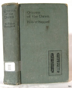
Book - Novel, H Rider Haggard, author, Queen of The Dawn, 1925
H. Rider Haggard (1856-1925), a British author, wrote fiction and non-fiction works and had letters and articles published in newspapers and journals. His novel 'Queen of the Dawn' was published in 1935. Thenovel's cover and Fly page display hieroglyphics, which suggest that this story was set in Egypt. The book is part of Flagstaff Hill's Pattison Collection. The book was published by the British firm Hutchinson & Co. operated for almost 100 years 1887-1985, before it underwent several mergers. The book has additional importance for its connection to the Pattison Collection, which, along with other items at Flagstaff Hill Maritime Village, was originally part of the Warrnambool Mechanics' Institutes’ Collection. The Warrnambool Mechanics’ Institute book collection has historical and social significance for its strong association with the Mechanics Institute movement and its important role in people's intellectual, cultural and social development throughout the latter part of the nineteenth century and the early twentieth century. The collection of books is a rare example of an early lending library and its significance is enhanced by the survival of an original collection of many volumes. The Warrnambool Mechanics' Institute’s publication collection is of both local and state significance.Queen of The Dawn: A love tale of old Egypt Author: H Rider Haggard Publisher: Hutchinson & Co 1st Published in 1925 Green hardcover book with hieroglyphics on the cover, inscriptions on the label and stamps. Part of the Pattison Collection. Label text: "PAT FIC HAG" Stamp, red ink: "W'bool Public Library" Sticker: "Corangamite Regional Library Service" Handwritten: "1298" Hieroglyphics, two, with translations: "Beautiful ascendress of pyramids" and "Great mistress of the dawn"flagstaff hill, flagstaff hill maritime museum and village, warrnambool, maritime museum, maritime village, great ocean road, shipwreck coast, pattison collection, ralph eric pattison, warrnambool mechanics’ institute, mechanics’ institute library, warrnambool library, free library, corangamite regional library service, h. rider haggard, 1925, hutchinson & co., queen of the dawn -
 Flagstaff Hill Maritime Museum and Village
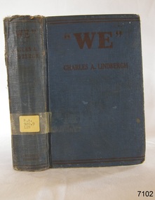
Book, We
Pattison Collection This item is from the ‘Pattison Collection’, a collection of books and records that was originally owned by the Warrnambool Mechanics’ Institute, which was founded in Warrnambool in 1853. By 1886 the Warrnambool Mechanics’ Institute (WMI) had grown to have a Library, Museum and Fine Arts Gallery, with a collection of “… choice productions of art and valuable specimens in almost every branch and many wonderful national curiosities are now to be seen there, including historic relics of the town and district.” It later included a School of Design. Although it was very well patronised, the lack of financial support led the WMI in 1911 to ask the City Council to take it over. In 1935 Ralph Pattison was appointed as City Librarian to establish and organise the Warrnambool Library as it was then called. When the WMI building was pulled down in 1963 a new civic building was erected on the site and the new Warrnambool Library, on behalf of the City Council, took over all the holdings of the WMI. At this time some of the items were separated and identified as the ‘Pattison Collection’, named after Ralph Pattison. Eventually, the components of the WMI were distributed from the Warrnambool Library to various places, including the Art Gallery, Historical Society and Flagstaff Hill. Later some were even distributed to other regional branches of Corangamite Regional Library and passed to and fro. It is difficult now to trace just where all of the items have ended up. The books at Flagstaff Hill Maritime Village generally display stamps and markings from Pattison as well as a variety of other institutions including the Mechanics’ Institute itself. RALPH ERIC PATTISON Ralph Eric Pattison was born in Rockhampton, Queensland, in 1891. He married Maude Swan from Warrnambool in 1920 and they set up home in Warrnambool. In 1935 Pattison accepted a position as City Librarian for the Warrnambool City Council. His huge challenge was to make a functional library within two rooms of the Mechanics’ Institute. He tirelessly cleaned, cleared and sorted a disarrayed collection of old books, jars of preserved specimens and other items reserved for exhibition in the city’s museum. He developed and updated the library with a wide variety of books for all tastes, including reference books for students; a difficult task to fulfil during the years following the Depression. He converted all of the lower areas of the building into a library, reference room and reading room for members and the public. The books were sorted and stored using a cataloguing and card index system that he had developed himself. He also prepared the upper floor of the building and established the Art Gallery and later the Museum, a place to exhibit the many old relics that had been stored for years for this purpose. One of the treasures he found was a beautiful ancient clock, which he repaired, restored and enjoyed using in his office during the years of his service there. Ralph Pattison was described as “a meticulous gentleman whose punctuality, floorless courtesy and distinctive neat dress were hallmarks of his character, and ‘his’ clock controlled his daily routine and his opening and closing of the library’s large heavy doors to the minute.” Pattison took leave from 1942 to 1945 to serve in the Royal Australian Navy, Volunteer Reserve as Lieutenant. A few years later he converted one of the Museum’s rooms into a Children’s Library, stocking it with suitable books for the younger generation. This was an instant success. In the 1950’s he had the honour of being appointed to the Victorian Library Board and received more inspiration from the monthly conferences in Melbourne. He was sadly retired in 1959 after over 23 years of service, due to the fact that he had gone over the working age of council officers. However, he continued to take a very keen interest in the continual development of the Library until his death in 1969. The Pattison Collection, along with other items at Flagstaff Hill Maritime Village, was originally part of the Warrnambool Mechanics' Institute’s collection. The Warrnambool Mechanics’ Institute Collection is primarily significant in its totality, rather than for the individual objects it contains. Its contents are highly representative of the development of Mechanics' Institute libraries across Australia, particularly Victoria. A diversity of publications and themes has been amassed, and these provide clues to our understanding of the nature of and changes in the reading habits of Victorians from the 1850s to the middle of the 20th century. The collection also highlights the Warrnambool community’s commitment to the Mechanics’ Institute, reading, literacy and learning in the regions, and proves that access to knowledge was not impeded by distance. These items help to provide a more complete picture of our community’s ideals and aspirations. The Warrnambool Mechanics Institute book collection has historical and social significance for its strong association with the Mechanics Institute movement and the important role it played in the intellectual, cultural and social development of people throughout the latter part of the nineteenth century and the early twentieth century. The collection of books is a rare example of an early lending library and its significance is enhanced by the survival of an original collection of many volumes. The Warrnambool Mechanics' Institute’s publication collection is of both local and state significance. We Author: Charles A Lindbergh Publisher: Cornstalk Publishing Co Date: 1927 The label on the spine with typed text RA 920.9 LIN Pastedown front endpaper has a sticker from Warrnambool Mechanics Institute and Free Library book, we, charles a lindbergh, pattison collection, warrnambool library, warrnambool mechanics’ institute, ralph eric pattison, corangamite regional library service, warrnambool city librarian, mechanics’ institute library, victorian library board, warrnambool books and records, warrnambool children’s library, great ocean road, shipwrecked-coast, flagstaff-hill, flagstaff-hill-maritime-museum, warrnambool, maritime-museum, shipwreck-coast, flagstaff-hill-maritime-village, shipwrecked-artefact -
 Ringwood and District Historical Society
Newspaper Cuttings, Local Ringwood Development newspaper cuttings 1989-2009, 1938 +
Newspaper cuttings about local development from Judity Learhey.Newspaper cuttings about local development from Judity Learhey. Manila folder dated 1989 and 2009. +Additional Keywords: Learhey, Judith -
Ringwood and District Historical Society
Pamphlets, Vic Roads, Pamphlets about Ringwood Bypass development, and one map. 1991-96, 1991-1996
Pamphlets about Ringwood Bypass development. Qty 6. With one map. -
Ringwood and District Historical Society
Collection of photocopies, Cadbury Schweppes, History and photographs of the development of Cadbury Schweppes in Ringwood between 1967-1975, 1967-1975
Letter to Gerry Robinson and some history and photographs of the development of Cadbury Schweppes in Ringwood between 1967-1975.10 pages with photographs pages 1-10; 1 page "The Road Ahead" page11; 1 page Cadbury newsletter February 1975, page 12; 1 letter to Gerry Robinson, page 13 +Additional Keywords: Robinson, Gerry -
Ringwood and District Historical Society
Documents, Court Recordings Services Pty Ltd, Eastland Development - Supreme Court Case transcripts 1963, 1963
Transcript of the court case in the Supreme Court of Victoria between 12 plaintiffs from the Ringwood Community and the defendants, the Mayor, Councillors and citizens of the City of Ringwood before Mr Justice Gillard. Started on 29-Jul-1963 and continued for several days.5 bundles of typed foolscap pages - transcript of the court case in Supreme Court of Victoria in 1963 pertaining to the development of Eastland. 4 bundles in faded green folders Vol.1-4. +Additional Keywords: Gillard, Mr Justice -
Ringwood and District Historical Society
Notebook, Burnside, Marie, Ringwood - Short Notes on its Development 1857-1963: Original manuscript and photos by Mrs. M Burnside, >1963
Notes made by Marie Burnside with the co-operation of the R.H.R.G. for the book entitled 'Ringwood - Short notes on it's development 1857 - 1963.'1. Stenographers notebook 15pp used. Lemon coloured cover with red printing.; 2. Patterned covered book - with pasted in typewritten pages and pictures. +Additional Keywords: Burnside, Marie -
Ringwood and District Historical Society
Collected Papers, Collection of varied handwritten and typed notes on the development of Ringwood. 1924-1981, 1924-1981
Collection of varied handwritten and typed notes on the development of Ringwood. -
Ringwood and District Historical Society
Pamphlets, Council Annual Reports, 1956 to Ringwood Ratepayers and 1976 to Citizens of Ringwood, and Invitation to Maroondah Trade and Industry Development Group Luncheon, 1974, 1. 25-Oct-1974|2. Jan 1956|3. 3-Nov-1976
Three pamphlets relating to Ringwood's Development and notices to ratepayers.1. Invitation. Orange coloured bifold with black printing; 2. Report. White four page foolscap. Black printing. Borough Crest on front page.; 3. Report. Cream bifold with blue printing. Map with 5 photos. +Additional Keywords: Kelly, Alfred (Town Clerk) / Smart G.R.B. (Mayor)1.Trade and Industry development group - Maroondah.; 2. Ringwood Council Annual Report to the ratepayers.; 3. A report to the citizens of Ringwood. -
Ringwood and District Historical Society
Document, History of development of the Ringwood Courthouse. (undated)
History of development of the Ringwood Courthouse. Includes a light-hearted paragraph. 1 Page. -
Ringwood and District Historical Society
Newspaper Cutting, The Sun, Ringwood Development article (Sun Newspaper) 23 Aug 1960, 23-Aug-60
Article about land 'frieze' of the 16 acres of land for the proposed development site for Eastland.Article about Ringwood development in Sun newspaper. Double page. +Additional Keywords: Lavis, A.G., Mayor / Dwerryhouse, F.P., Town ClerkLand 'Frieze' at Ringwood. -
Ringwood and District Historical Society
Envelope, Packet: Ringwood Borough Council Newspaper Articles 1909-1959; Correspondence re Borough Development
Borough Council:; Newspaper cuttings 1909 - 1957; Correspondence - Borough Development -
Ringwood and District Historical Society
Newspaper Cutting, Maroondah Journal, Ringwood Primary School to Federation Estate Development - Cutting. 1998, 1998
Ringwood Primary School was closed in 1996 and building redevelopment commenced. The Federation Estate was created and became a home to community groups including the Eastern Volunteer Resource Centre.Article about Ringwood Primary School being developed into Federation Estate. Cutting from Maroondah Journal. +Additional Keywords: Gurr, Peter (Councillor)School gains new lease of life -
Ringwood and District Historical Society
Booklet, Feasibility Study of Town Hall Complex, Maroondah Hwy Ringwood - 1970
Used in the development of the Civic centre - pamphlets 1968. Feasibility study and report of the existing town hall complex at the corner of Maroondah Highway and Civic Place, Ringwood, April 19701. Report and feasibility study. Black 2-hole bound book with 22 inserted pages typrwritten.; 2. Bifold pamphlets with dark brown/sepia picture on front. Other pages printed. +Additional Keywords: Marshall, B R / Dwerryhouse, F P (Town Clerk) -
 Ringwood and District Historical Society
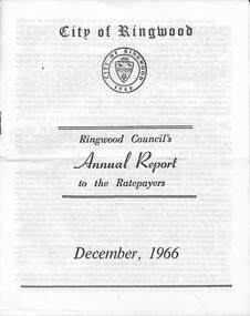
Pamphlet, F.P. Dwerryhouse, Town Clerk and Treasurer, Ringwood Council's Annual Report To The Ratepayers - December 1966, 1966
City of Ringwood community information annual report for 1966, including sections covering Finance, Sanitary Service Charge, Municipal Library, Memorial Clock Tower, Reserves, Civic Centre, Maroondah Highway Reconstruction, Other Road Works, Building Activity and Development - Education, MacRobertsons Pty. Ltd. & Travellers' Facilities (Ringwood Station), Appreciation - Decimal Currency Conversion, Annual Special Clearance of Refuse, Garbage Removal, Fly Control, Immunisations, Infant Welfare Centres, Retention of Native Flora, Home Help Service, Dogs, Horse Riding, Fire Hazards and Burning Off, Secondary School Grants, and list of Council Representatives.rinx -
 Ringwood and District Historical Society
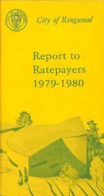
Booklet, City of Ringwood Report to Ratepayers 1979-1980, 1979
Yellow covered community information booklet for Ringwood residents covering Council and Parliamentary contact details, Council Meeting Dates, Justices of the Peace, Council Finances, Immunizations, Major Works, Planning (Live Theatre/Functions Centre, including Floor Plan), Health and Community Services, Christmas Holiday Play Centres, Lord Mayor's Children's Camp, Rates, Municipal Elections, Dogs, Rubbish Tip, Overhanging Foliage, Vandalism, Building By-laws, Ringwood Library (28 Warrandyte Road), Golf Course, Fred Dwerryhouse Swimming Centre, Netball Complex, Growth of Ringwood Commercial Centre, McAlpin's Reserve Development Plan, Netball Complex, Citizenship Ceremonies, Mini Bikes, School Crossing Supervision, Family Fun Day, Highland Carnival. Includes three City of Ringwood Free Tipping Vouchers valid until the end of 1980 and list of tip charges from October, 1979.Mayor's Message - Cr. P. Gotlib. Inside front cover - Green tinted photograph of Ringwood Memorial Tower captioned: Ringwood - "A Happening Community". Back cover - Green and yellow diagram of Ringwood Civic Centre Development, Stage 2. Floor Plan and description of Theatre and Functions Centre expected to be completed by early 1980.rinx -
 Ringwood and District Historical Society
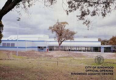
Booklet, City of Ringwood Official Opening Ringwood Aquatic Centre, 1986
Official Opening Programme of Ringwood Aquatic Centre incorporating the Fred Dwerryhouse Swimming Centre by Cr. Bill Wilkins, J.P., Mayor, on Sunday 27th July, 1986. Includes colour photographs and separate double-sided A4 public information brochure advertising facilities and opening hours.Summary of facility development from Mayor's opening address: These pools were originally built in 1970 and the complex was named in honour of the Town Clerk of Ringwood for many years - Fred Dwerryhouse Swimming Centre. In 1980 the pools were heated and in 1985 Ringwood Council decided to enclose the main pool, install air conditioning, add a diving area, heat the main pool all year, and generally upgrade the entire complex.rinx -
 Ringwood and District Historical Society
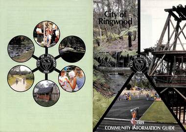
Booklet, City of Ringwood 1989 Community Information Guide, 1989
Community information booklet issued by City of Ringwood for 1989 - covering the facilities and activities of the Ringwood Council and other local organisations and associations. Cover photographs: Front - Fern Gully at Ringwood Lake, Poppett Head at rear of Lake, Athletics Track. Back - Highland Carnival, Wombalano Park, Miners Cottage at Ringwood Lake, Bike Path, Water Cascade at rear of Lake.CONTENTS: (page no.) 1. COUNCIL SERVICES After School Activities Programme 29 Aged Services 31, 32 & 33 Aquatic Centre 20 & 21 Budget 14 Building Information 16 By-Laws 26 Chief Executive's Message 9 Children's Services 29 Civic Centre 4 Committees of Council 5 Common Questions 36 Community Plan 10 & 11 Council Meeting Dates 4 Council Representatives 8 Councillors 6 & 7 Dogs 26 Dual Occupancy 12 Emergency Telephone Numbers 63 Family Day Care 29 Fire Hazards 27 Garbage 34 & 35 Golf Course 24 Home Handyman Services 31 Home Help 31 Incinerators 26 Knaith Road Child Care Centre 29 Library 23 Maternal and Child Health 28 Mayoral Message – Cr. R. Gardini 3 Meals on Wheels 31 Members of Parliament 62 Parks and Gardens 18 Rates 25 Residential Development Provisions 12 & 13 Ringwood Bypass Road 13 Ringwood Convention Centre & Performing Arts Centre 22 Ringwood District Centre 14 Staff 10 Town Planning 17 Works Depot 30 Youth Outreach Worker 33 2. LOCAL COMMUNITY SERVICES Accommodation 37 Alcoholism 37 Birthright 38 Blind 38 Care Force 39 Catholic Family Welfare Bureau 39 Central Ringwood Community Centre 39 Childbirth and Parenting Association 39 & 40 Churches 40 & 41 Community Services Victoria 42 Day Centres and Drop In Centres 43 Do Care 43 Drugs 43 Elderly Day Care 44 Emergency Housing 45 Family Planning Services 45 Financial Counselling 46 Hearing Aid Service 47 Hospitals 47 Housing 48 Information 48 Legal 49 Literacy 50 Lone Parents 50 Marriage Celebrants 50 Maroondah Social Health Centre 51 Neighbourhood Mediation Centre - Outer East 51 North Ringwood Community House 52 Nursing 52 Optometric Services 52 Playgroups 53 Podiatry 53 Pre-Schools 54 Red Cross 55 Retirement 55 Ringwood Croydon Advisory Service 55 Schools 56 & 57 Senior Citizens' Centres 58 Transport 59 Twins 59 Unemployment 60 Volunteering 60 Youth Accommodation Project (Maroondah). 60 Youth Emergency Accommodation Services... 60 rinx -
 Ringwood and District Historical Society
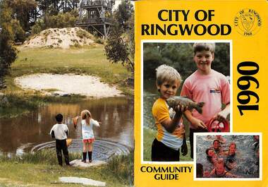
Booklet, City of Ringwood 1990 Community Guide, 1990
Community information booklet issued by City of Ringwood for 1990 - covering the facilities and activities of the Ringwood Council and other local organisations and associations.CONTENTS: (page no.) 1. COUNCIL SERVICES After School Programme 33 Aged Services 33, 34,35 Aquatic Centre 15,16,17 Aquatic Centre Bonus Vouchers 17 Biological Wasp Control 24 Budget 13,14 Building information 26 By-Laws 29 Chief Executive's Message 9 Children's Services 44 Citizenship 35 Civic Centre 4 Committees of Council 5 Common Questions 39 Council Meeting Dates 4 Council Representatives 8 Councillors 6,7 Dogs 29 Emergency Telephone Numbers 67 Family Day Care 32 Fire Hazards 29 Garbage 37 Golf Course 19 Health and Environmental Services 24 Home Handyman Services 54 Home Help 33 Immunisation 25 incinerators 29 Knaith Road Child Care Centre 32 Library 22 Library Service Senior Citizens 34 Maternal and Child Health 31 Mayoral Message - Cr. Lillian Rosewarne 3 Meals on Wheels 33 Members of Parliament 40 Parks and Gardens 22,23 Rates 28 Residential Development Provisions 12 Ringwood Bypass Road 11 Ringwood Convention Centre & Performing Arts Centre 20 Ringwood District Centre 13 Ringwood Festival 21 Shopping Bus 34 Staff 10 Town Planning 26 Works Depot 36 Youth Outreach Worker 36 2. LOCAL COMMUNITY SERVICES Accommodation 42 Aged Accommodation 42 Alcoholism 42 Arthritis Foundation 43 Arts and Crafts 43 Blind 43 Care Force 43 Catholic Family Welfare Bureau 43 Central Ringwood Community Centre 43 Childbirth and Parenting Association 44 Churches 45 Community Services Victoria 47 Day Centres and Drop-in Centres 48 Disabled Facilities 49 Do Care 50 Drugs 50 Elderly Day Care 50 Emergency Housing 51 Family Planning Services 51 Financial Counselling 52 Hearing Aid Service 53 Hospitals 54 Housing 54 Information 55 Legal 55 Literacy 55 Lone Parents 57 Marriage Celebrants 57 Maroondah Social Health Centre 57 Neighbourhood Mediation Centre - Outer East 57 North Ringwood Community House 53 Nursing 59 Optometric Services 59 Playgroups 60 Pre-Schools 60 Red Cross 61 Retirement 62 Ringwood Croydon Advisory Service 62 Schools 63 Senior Citizens' Centres 65 Transport 66 Twins 66 Unemployment 66 Volunteering 66 Youth Accommodation Project (Maroondah) 67 Youth Emergency Services 67 rinx -
 Ringwood and District Historical Society
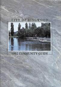
Book, City of Ringwood, City of Ringwood 1992 Community Guide, 1992
Community information book issued by City of Ringwood for 1992 - covering the facilities and activities of the Ringwood Council and other local organisations and associations. Includes two Aquatic Centre entry vouchers valid until June 30th, 1992.CONTENTS: (page no.) 1991/92 COUNCIL REPRESENTATIVES 4 1992 CALENDAR 51 AQUATIC CENTRE 8 AQUATIC CENTRE VOUCHERS 49 CHIEF EXECUTIVE'S REPORT 6 CIVIC CENTRE TELEPHONE INDEX — DIRECT DIALLING 53 COMMUNITY DIRECTORY 35-47 COMMUNITY SERVICES 17-19 COUNCIL & COMMITTEE CYCLES 4 COUNCIL FINANCES & 1991/92 RATES 16 COUNCILLORS 3 FUNCTIONAL RESPONSIBILITIES 15 HISTORY OF RINGWOOD 5 HOUSING & RESIDENTIAL DEVELOPMENT 29-30 INFRASTRUCTURE 34 LOCAL, STATE & FEDERAL GOVERNMENT ELECTIONS 32 MANAGEMENT TEAM 14 MAYORAL MESSAGE – Cr. Max Williams 1 NEIGHBOURHOOD MAP 26-27 NOTES 52 PAPER & CARDBOARD COLLECTION SERVICE 22 PARKS & RESERVES — PUBLIC FACILITIES 31 PROTECTING OUR COMMUNITY 23-24 PROTECTING THE ENVIRONMENT 20-21 RINGWOOD FESTIVAL & HIGHLAND CARNIVAL 13 RINGWOOD GOLF COURSE 7 STRATEGIC BIKE PLAN 11 STREET INDEX A-L 25 STREET INDEX L-Z 28 THE LIBRARY 12 THE RINGWOOD CONVENTION & PERFORMING ARTS CENTRE 10 TRAFFIC MANAGEMENT 33 YOUR PERSONAL DIRECTORY 50 rinx -
 Ringwood and District Historical Society
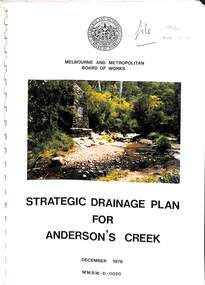
Book, Strategic Drainage Plan For Anderson's Creek, 1978
Melbourne and Metropolitan Board of Works 1988 report on physical characteristics of Anderson's Creek and development of management strategies formulated in consultation with Cities of Croydon, Doncaster & Templestowe, and Ringwood, in which the Anderson's Creek Basin is located. Foreword by Alan H. Croxford, M.M.B.W. Chairman. -
 Ringwood and District Historical Society
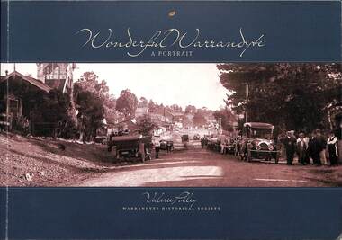
Book, Valerie Polley, Wonderful Warrandyte - A Portrait, 2014
Soft-covered book by Valerie Polley, Warrandyte Historical Society, featuring photographs, sketches and text outlining early and contemporary development of Warrandyte township and community, first published in April 2014.Front cover - Peace Day celebrations in Warrandyte, July 1919. Acknowledgements: The book project Wonderful Warrandyte-A Portrait was made possible by a grant under the Australian Government's 2012-2013 Your Community Heritage Program (Your Community Heritage - Sharing Community Heritage Stories). Several members of the Warrandyte Historical Society were involved in this book project which evolved after several years of development ideas. Valerie Polley wrote the text and selected photographs. Special thanks go to the Steering Committee of Margaret Kelly, Andy Bevan-Jones, Richard Morton and Wayne Rankin for their knowledgeable input and beneficial editing advice, Murray Houghton for his specialised historical knowledge and advice on further references, and Diane Baird for editing. The book would not have been possible without all the dedicated work of the Society's members, past and present, who have contributed to the Society's substantial archive. All proceeds from the sale of this book go to the Warrandyde Historical Society. Photographs: Stephen Reynolds, Austin Polley, Valerie Polley, Wayne Rankin, Ron Harris, Merv Naughton. Flora and Fauna photography by Nth Warrandyte, Osborne Peninsula, Landcare, Inc. Maps: Jock Macneish -
 Ringwood and District Historical Society
Book, Diane Baird, Digging Into History - Goldmining in Warrandyte, 2007
Information about early mining in Victoria's first gold field. Cover photographs: Front cover - Fossickers working below the water-wheen driven stamper battery located on the south side of the Yarra River upstream of the Warrandyte Bridge. Back cover - The Old Post Office, Warrandyte, in 1906, now the premises of the Warrandyte Historical Society Museum and Archive, 111 Yarra Street.Acknowledgements: Several members of the Warrandyte Historical Society were involved in the development of this publication. It was developed and written by Diane Baird; Murray Houghton and Ted Rotherham provided specialist historical details and further references; Jo Laurence and Shirley Rotherham collected and identified photographs; Brian Laurence prepared images for electronic format; and Richard Morton edited and formatted the text. The Society gratefully acknowledges the dedicated work of all its members who collect, preserve and share Warrandyte's history. In particular, the research by the late Bruce Bence and the dedicated work of the late Jo Laurence have been an invaluable contribution to the history of Warrandyte. -
 Ringwood and District Historical Society
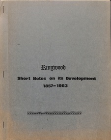
Booklet, Ringwood - Short notes on its development 1857-1963, Feb-64
Notes prepared by Mrs M. Burnside with help from the Ringwood Historic Research Group for use in schools for history projectsPublication by Ringwood Historical Research Group intended to aid in studies and understanding of the beginnings of Ringwood, Victoria, compiled by Mrs. M. Burnside for use in school projects, distributed to school libraries throughout Ringwood.Printed first in February 1964; reprinted December 1964 with some amendments; third reprint September 1965. -
 Ringwood and District Historical Society
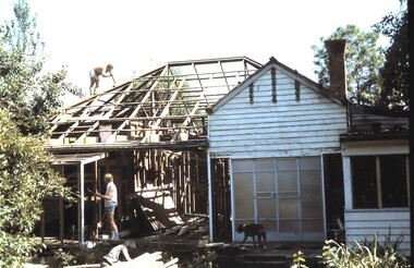
Photograph, Frazer's orchard 'Alkoomi' North Ringwood - Farm house demolition c1971
Harold Frazer’s “Alkoomi” orchard farm house, Oban Rd Nth Ringwood, undergoing demolition after land was sold to A.V. Jennings for housing development. Circa 1971 -
 Ringwood and District Historical Society
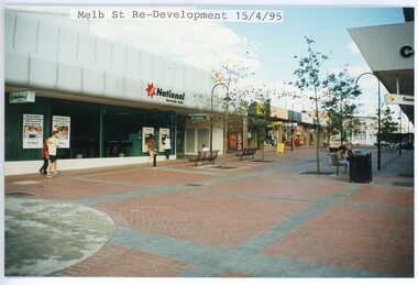
photograph, Eastlink Ringwood Bypass Construction-Melb St Re-Development 15/4/95
Colour photographWritten on back of photo: "Melbourne St Re-Development 15/4/95 -
 Ringwood and District Historical Society
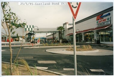
photograph, Eastlink Ringwood Bypass Construction-Eastland-Bond St 25/5/95
Colour photographWritten on back of photo: "Eastland Development-Bond St 25/5/95"