Showing 3083 items
matching a. miles
-
 Bendigo Historical Society Inc.
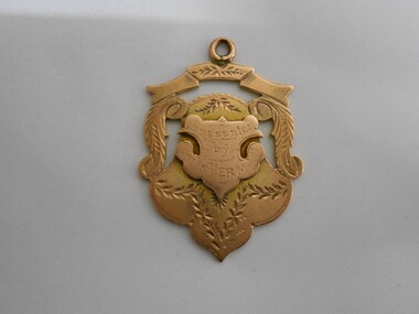
Medal - CHARLES EDWIN HUNT COLLECTION: MEDAL, 1895-1896
Rose gold coloured Medal won by C E Hunt of Ramblers C.C. for 25 and 50 mile Interclub Championship 1895-96. Presented by Louis Herman1897-8. Has Hallmark. -
 Whitehorse Historical Society Inc.
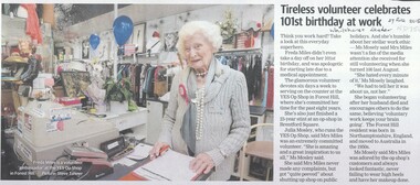
Article, Freda Miles, 2018
Freda Miles celebrated her 101st birthday at the Yes Op Shop Forest HillFreda Miles celebrated her 101st birthday at the Yes Op Shop Forest Hill where she has been a volunteer six days each week, for the last 8 years.Freda Miles celebrated her 101st birthday at the Yes Op Shop Forest Hillmiles, freda, yes op shop, forest hill -
 Camberwell RSL Sub-Branch
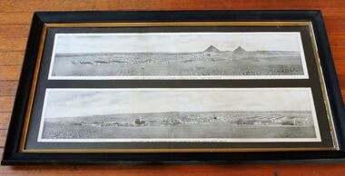
Photo, Australian 1st Division in Mena Camp, 10 miles from center of Cairo. March 1915, 1915
Australian 1st Division Camp at MenaUniqueInteresting photo showing the Mena camp of the Australian 1st Division from two perspectives. The spread was over several miles and some idea of the size can be made from the images of the Pyramids. -
 Lakes Entrance Historical Society
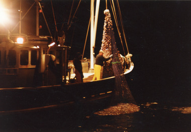
Photograph - Southern Hunter, 1991 c
Photo taken from Minawie|At this time Southern Hunter owned by Ted Jones, Skipper Darren Jones.|Minawie owned by Wayne SmithColour photograph of fishing net containing four tons of school whiting being hauled aboard a fishing boat, the Southern Hunter off Three Mile Beach, Wilson Promontory Victoriafishing industry, ships and shipping, ocean -
 Ringwood and District Historical Society
Booklet - Souvenir, Mail' Print, Souvenir booklet - Laying of Foundation Stone of Ringwood Town Hall, Whitehorse Road, Ringwood - 1927, 1927
Book produced on the occasion of laying the foundation stone of the new Ringwood town hall 1927.Booklet - Souvenir of the Laying of the Foundation Stone of the New Municipal Chambers, Whitehorse Road, Ringwood, on Saturday 19th February, 1927, by the mayor (Cr. A. Temple Miles, J.P.).; Cost of Town Hall 6,000 Pounds. +Additional Keywords: Miles, A. Temple / Leith, A C Architect / Roberts, J / McAlpin J B / MacKindlay, W / Blood, A / Wilkins, R G / Long, A F B / Lucas, F R / Jenkin, W T / Langley, A T -
Ringwood and District Historical Society
Book, Red Cross members, Book containing details of Red Cross training during the 1940s. The book contains a newspaper clipping re 'Red Cross Work at Ringwood', 1940s
The book contains details of training received by individuals during the war years. The training includes First Aid, Home Nursing, Cookery, Catering, Anti Gas,Transport, Life Saving, Drill, Sewing, Blood Transfusions.Book containing details of Red Cross training during the 1940s. The book contains a newspaper clipping re 'Red Cross Work at Ringwood'. +Additional Keywords: Miles, AT / McAllister / Palmer / Parker / Hewitt -
 Victorian Aboriginal Corporation for Languages
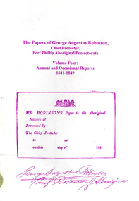
Book, Ian D Clark, The papers of George Augustus Robinson, Chief Protector, Port Phillip Aboriginal Protectorate : volume four : annual and occasional reports : 1841-1849, 2001
This is a collection of Official Reports from the Chief Protector of Aborigines. It includes expedition reports to the Western Interior, 1841, a journey of 1,100 miles to the tribes of the North West and Western Interior, 1845 and Annual Reports.document reproductionsport phillip protectorate, george augustus robinson, western district, noorat, lake boloke, lake bolac, lake corangemite, portland, koroit, koonong wootong, burrumbeep, tarecurrumbeet, wimmera, lake hindmarsh, rivoli bay, mount gambier, murray river, swan hill, goulburn, loddon, mount rouse -
Whitehorse Historical Society Inc.
Map, Ringwood, c1922
Victoria Ringwood Survey map 1 inch to 1 mile.Victoria Ringwood Survey map 1 inch to 1 mile. Covers Eastern suburbs of Melbourne from Richmond to Macclesfield, Heidelberg / Lilydale to Dandenong. Prepared by Commonwealth Section, Imperial General Staff.Victoria Ringwood Survey map 1 inch to 1 mile. eastern suburbs, melbourne, maps -
 8th/13th Victorian Mounted Rifles Regimental Collection
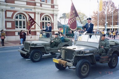
Photograph - Reserve Forces Day march
Staff - Sergeant Maurie Miles and WO 2 Lou Madjeric standing in Jeeps carrying guidons of 8th and 13th Light Horse, Reserve Forces Day Parade, Albury, 4 July 1998.reserve forces, parade, albury, guidon, military -
 8th/13th Victorian Mounted Rifles Regimental Collection
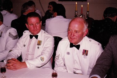
Photograph - McDonald & Miles
The 8th/13th Victorian Mounted Rifles was raised as a regiment of the Royal Australian Armoured Corps on 1 May 1948 with Headquarters in Melbourne and squadrons in Sale, Benalla/Wangaratta and Albury. In 1955 Regimental Headquarters moved to Wangaratta and a second squadron was located at Albury. The Sale squadron transferred to 4th/19th Prince of Wales’s Light Horse. In 1977 8/13 VMR Regiment was reduced to an independent squadron A Squadron 8th/13th Victorian Mounted Rifles and in 1991 was linked with 4th/19th Prince of Wales’s Light Horse forming the VMR Squadron of that regiment.Colour photograph of Warrant Officer McDonald, RSM Royal Australian Armoured Corps, and former Staff Sergeant M. Miles 8/13 Victorian Mounted Rifles at Dinner 25 May 1991.dinner, miles, vmr, military -
Canterbury History Group
Document - Former Malone's Canterbury Club Hotel, 208 Canterbury Road Canterbury, Lewis, Miles, 1/07/1990 12:00:00 AM
Miles Lewis comments on the proposed redevelopment of 208 Canterbury Road Canterbury, based on a set of six drawings by Collective Design Pty Ltd. ( this should consist of 2 pages but only 1 remains}canterbury, canterbury club hotel, lewis> miles, canterbury mansions, canterbury road, maling road, wattle valley road -
 Wodonga & District Historical Society Inc
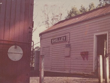
Photograph - Fred Rochow Railways Collection - Shelley Station
The Fred Rochow Railways Collection incorporates photos related to the operation of the Wodonga Railway Station including different types of trains and railways staff C. 1930 – 1990. It was donated to the Wodonga Historical Society by Fred Rochow, a railwayman who spent many years based in Wodonga. He joined the Victorian Railways on 17th June l947 and retired in 1988. For some time, he was a member of the Australian Federated Union of Locomotive Enginemen and served a term as a member of the Trades Hall Council. He had an extensive knowledge of the struggles that took place to achieve better conditions for railway workers. Fred worked for many years as a fireman and then worked his way up the ranks to driver, experiencing many changes from the days of steam locomotives through to diesel trains, locomotives and even the modern XPT train. He worked throughout Victoria at different stages of his career, with his final working years focused on the northeast of Victoria and the Albury to Melbourne line. After his retirement, Fred continued to share his love of steam miniature trains with the community. Shelley Railway Station - Shelley was once Victoria's highest railway station, located 781 metres above sea level. The Shelley Railway Station was opened in 1916 and closed in 1979. The railway was used early in its life to transport farmer’s livestock from the Upper Murray to Wodonga. From the 1950s the railway was used heavily to transport equipment and machinery from Wodonga to the Upper Murray to help build the Snowy Mountains Hydro Electric Scheme. The Snowy Hydro Scheme was completed in 1974 and after several years of low level use, the railway was closed. Some remnants of the Shelley Station passenger platform can still be seen today, along with some information boards. The Shelley Railway Station now forms part of the High Country Rail Trail.This collection has local and statewide significance as it captures images of trains, locomotives and personnel who operated the railway services in Wodonga and throughout Northeast Victoria. The railways played a critical role in opening up Victoria and connecting Australia for trade, business, social communication and transport.Shelley Railway Station. This image shows the tank where the hand brakes were lifted. They were applied again at the "up" side of Koetong for about another 10 miles then lifted near Bullioh.railways wodonga, fred rochow, shelley station, high country rail trail -
 Melbourne Tram Museum
Document - Memorandum, Ministry of Munitions, Sunday School Union Procession, 1943
Memorandum and note for tram scheduling for an exhibition of armaments and munitions through Melbourne on Friday 29 October 1943. 17 pages "Miles of Munitions 1943" List of Sub-Assembly Areas. 12 pagestrams, tramways, instructions, events, world war 2 -
 Lakes Entrance Historical Society
Photograph - Gippsland Lakes, 2005 c
Colour aerial photograph of Ocean Grange on the Gippsland Lakes ocean beach ninety mile beach in foreground Cresent Island channel through to Lake King Raymond Island in distance Paynsville Victoriaaerial photograph, settlement, gippsland lakes -
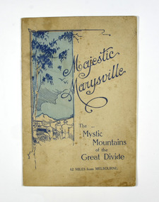 Marysville & District Historical Society
Booklet, Marysville Tourist Association, Magestic Marysville-The Mystic Mountains of the Great Divide, 1920's
An information guide of day trips to attractions in and around Marysville in Victoria. This booklet was produced by the Marysville Tourist Association.Paperback. Cover is beige with a drawing of two people standing next to a car looking at the view. The title is in dark blue across the front.non-fictionAn information guide of day trips to attractions in and around Marysville in Victoria. This booklet was produced by the Marysville Tourist Association.marysville, victoria, marysville tourise association, steavenson falls, keppel falls, cameron cascades, cumberland, mt cathedral, eildon, snob's creek falls, wolfram mine, mt strickland, keppel's lookout, mt kitchener, mt edgar, mt gordon, nichol's lookout, michael dene, beauty spot, gilbert's gully, taggerty river, wood's point -
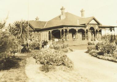
 Ringwood and District Historical Society
Photograph, Now Church of England property. Then front of Capt. Miles residence - 1965
Written on backing sheet, "Now Church of England property. Then front of Capt. Miles residence - 1965". -
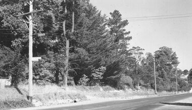
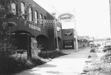 Ringwood and District Historical Society
Photograph, Maroondah Highway West, Ringwood- 1978. 15 mile peg at Guest's Furniture Store
Black and white photographPhotograph shows Guest's Furniture Forum store, and also the original 15 mile cement marker. -
 Geelong Cycling Club
Medallion, 1951
Awarded to participant L Stephenson of GWCC in 1951 on completion of the Melbourne to Warrnambool Road Race.L Stephenson is recorded from the late 1920s to 1951 and beyond as a successful racing cyclist with the GACC and GWCC. Awards of such medallions reflects the recognition given to the competitors of the Melbourne-Warrnambool road race over 163 Miles.Small enamelled medallion. It has a black background with green wings coming from a red centre figure. There are inscriptions on the black background and on a green header at the top of the badge. There are also inscriptions on the reverse side of the badge."Healing 1951 Melbourne-Warrnambool 163 Miles" "Jubilee Year 10/KC Luke Melbourne"geelong west cycling club; l stephenson; melbourne warrnambool road race; medallion; 1951; -
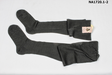 Whitehorse Historical Society Inc.
Clothing - Stockings
Pair of black lisle stockings with sticker joining the two together. (unused)The Faithful Sheer That gives Miles of Wear Fine Mercerised Lisle Nylon Reinforced Heel and Toe.costume, female footwear -
 Ringwood and District Historical Society
Photograph, 'Glamorgan', Capt. Miles' home in Warrandyte Road. c1935
Black and white photograph (2 images- one of house and garden, and one of driveway to house.)Written on back of photograph of house: " 'Glamorgan', Warrandyte Road, Ringwood. Capt. Miles' home. c1935." -
 Wodonga & District Historical Society Inc
Album - Hume Reservoir Australia Album - Plans and Progress Photos - River Murray Water Scheme, Department of Public Works, N.S.W, 1927
This set of photos is from a leather bound album bearing the inscription "HUME RESERVOIR AUSTRALIA" plus 'The Rt. Hon. L. C. M. S. Amery, P. C., M .P.' all inscribed in gold. It was presented to The Rt. Hon. L. C. M. S. Amery, P. C., M. P, Secretary of State for Dominion Affairs on the occasion of his visit to the Hume Reservoir on 2nd November 1927. This album is of local and national significance as it documents the planning and development of the Hume Reservoir up to 1927. It was the largest water reservoir in the British Empire. The album records the pioneering engineering work that went into its construction.1. Locality Plan and Plan of Dam. The dam is about ten miles by road upstream from Albury and about three-quarters of a mile below the confluence of the Mitta Mitta River and the Murray River. Its main features consist of a concrete portion across the bed of the river with earth embankment at both ends. The foundations throughout are on hard granite, found at an average depth of about 40 feet below the surface, the centre line being located to take advantage of the most favourable rock levels.Heading on page "WORKS UNDER RIVER MURRAY WATERS AGREEMENT/HUME RESERVOIR" Beneath top diagram "FIG. 1. ELEVATION" Beneath second diagram "FIG. 2. PLAN" On map "LOCALITY PLAN"hume reservoir australia, river murray waters scheme, hume weir diagrams, hume weir location -
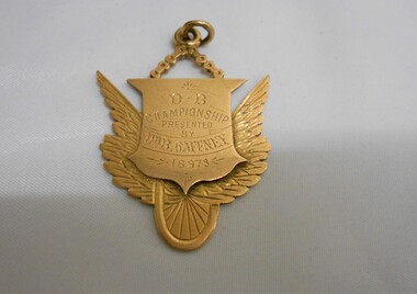 Bendigo Historical Society Inc.
Medal - CHARLES EDWIN HUNT COLLECTION: MEDAL, 1897-1898
Rose gold coloured Medal won by C E Hunt of Ramblers Team for 25 and 50 mile Interclub Championship 1897-8. Presented by Dr B Gaffney 1897-8. Has Hallmark. -
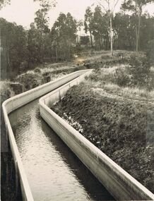 Bendigo Historical Society Inc.
Photograph - JOSEPH BRADY COLLECTION: COLIBAN RACE CONCRETE FLUMING
Photograph - black and white. Comments received with photo: Coliban Race Concrete grand fluming at 12.5 miles main channel; 8 feet wide, 4 foot 6 inches high constructed 1928.place, water, coliban race, john brady collection. coliban race -
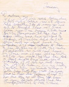 Bendigo Historical Society Inc.
Document - IAN DYETT COLLECTION: LETTER
Letter from Fred, no date, only Tuesday. He mentions that when finished here they may hire a car to travel to Perth, 700 miles away. He also mentions the auction and family matters.business, auctioneers, j h curnow & son pty ltd, ian dyett collection - letter, fred -
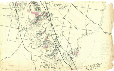 Beechworth Honey Archive
Hand-Drawn Map Centred on Armstrong by Frank Lebbell Frost Dec 1916
This is one of the maps drawn by Frank L. Frost while he was beekeeping in North-East Victoria. This particular map may be reference in the "Wooden" Diary on page 11.Hand-drawn map centred on Armstrong, a town 6 miles from Ararat. Details vegetation along Great Western Highway. Drawn with black pen and grey lead on paper. Features are marked in red.hand drawn, hand-drawn, map, armstrong, ararat, frost, beekeeper, beechworth honey -
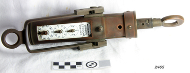 Flagstaff Hill Maritime Museum and Village
Ship Log, 1900-1920
Thomas Walker & Son was internationally renowned in the manufacturing of ships logs. Founding father Thomas Walker (1805–1871), an engineer in Birmingham, patented a mechanical log in 1878 which was a recording instrument that attached to a rail at the stern of a vessel connected by a long cord with a rotor which was towed behind the ship. The instrument dial recorded the distance travelled. Thomas Walker first went into business to manufacture stoves at 58 Oxford Street Birmingham. Walker’s self-feeding stove was widely lauded at the Paris Exhibition of 1855, winning a prize medal and kick starting the first of many notable innovations for the Walker family's manufacturing business. However, it wasn’t until working on an earlier ships log model invented by his Uncle that Thomas Walker became interested in the further development of this device, used to ascertain a ship’s speed. Walker continued to improve on the common log for the company of Massey & Sons and these improvements were deemed revolutionary. This log became a firm favourite of the West India Association (British-based organisation promoting ties and trade with the British Caribbean) and the most common log in use for two generations. It took till 1861 for Thomas Walker and his son, Thomas Ferdinand Walker (1831-1921) to patent the first Walker log of many. Together, with the introduction of the A1 Harpoon Log two years later, they established the Walker Log Business as a force to be reckoned with. By the time of his passing in 1871, Thomas Walker Snr had not only founded a family business with considerable staying power but also instilled a tradition of public service. Having sat as a representative on the Birmingham Town Council for 15 years and played an active role in public works, he was soon given the nickname of ‘Blue Brick Walker’. Much like his father, Thomas Ferdinand Walker changed the face of the maritime industry. His patent of 1897, the ‘Cherub’ log, was a notable departure from the past providing a far more accurate reading and replacing the majority of logs of the age. They were the first to produce an electric log and the Walker factory was one of the first to introduce the 48 hour work week for employees. This ship log was invented and made by a significant marine instrument maker and innovator of machinery. It demonstrates the huge leap taken to improve navigational accuracy at sea with an instrument that was in use for decades. Ship Log, three analogue dials calibrated in increments of Miles, the Rocket Log is a nautical instrument for measuring a vessel’s speed and distance traveled. The floating log was drawn behind the ship over a fixed time period in order to measure the distance traveled. The counter could measure enough miles to cover the maximum distance traveled by a ship in one day. The log has two distinct parts; a brass register, made by Walker, showing the distance recorded and the rotator made by Reynolds, that spins in the water driving the counter. both parts are connected by a linked chain. The register has a cylindrical brass body approx 4.5 cm diameter containing registering mechanism with hardened steel bearings. Distance is indicated by the three pointers on enamel plate as follows: graduated every 10 miles from 0-100; every mile from 1-10; every 1/4 mile from 1/4 -1. A brass sling and eye secured to the body enables it to be attached to the taffrail. The original rotator would have had a cylindrical tapered wooden body, approx 4.5 cm in diameter with three metal alloy fins or could be all made from brass. A towing eye is fitted to the tapered end. The two pieces of apparatus are connected by a length of linked chain, length 22.9 cm."Walkers Rocket Ship-Log Birmingham (Patented)" printed on face-plate. "Made by Thomas Walker".flagstaff hill, warrnambool, shipwrecked-coast, flagstaff-hill, flagstaff-hill-maritime-museum, maritime-museum, shipwreck-coast, flagstaff-hill-maritime-village, ship log, rocket log, mechanical ship log, measuring instrument, marine instrument, nautical instrument, speed recording instrument, ship log register, walker ship log, walkers rocket ship-log, thomas walker, thomas walker & son, thomas ferdinand walker, walker log business, reynolds ship log rotor, taffrail log, taff rail log, west india association -
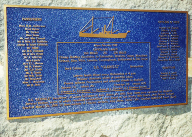 Lakes Entrance Historical Society
Photograph - The "Glenelg" Lakes Entrance, 25/3/2000
The "Glenelg" sank off the coast of 90 mile beach after leaving Lakes Entrance with the loss of 37 lives, only three survived. The passengers had embarked on a cruise to the lakes. It was announced on the Evening News when the wreck of the Glenelg was found 100 years later. LERHS has reference material on the inquest collected and donated by Ian Boyd whose grandmother was Stewardess aboard the GlenelgHistoricalColour photograph of memorial plaque on bluestone plinth on walkway beside Cunninghame Arm in memory of the lives lost on the wreck of the SS Glenelg Lakes Entrance Victoria. Also colour photographs taken at the unveiling of the memorial plaque by descendants of those lost on the "Glenelg" which sank on 25th March 1900. Named: Phyllis and Ian Boyd; Jeanne Davidson great granddaughter of Hilda Anderson; Aileen Knox, Ian Boyd, Elinor Boyd, Janet Gilbert, great grandchildren of Janet Boyd (Stewardess )who was lost on the Glenelg. Also two colour photographs taken when the Glenelg wreck was discovered off 90 mile beach 100 years after it was lost, showing divers who found the wreck, and announcer from TV News making the announcement. township, waterfront, shipwrecks, memorials -
 Sunshine and District Historical Society Incorporated
Photographs (1928), 'QUARTER MILE' BRIDGE Construction, 1928
One man lost his life during the building of this bridge. The bridge was constructed by the Victorian Railways between 1927 to 1929 to carry a new double track goods line. This enabled trains from all parts of the state except Gippsland to have direct access to the Tottenham marshalling and sorting yards. These yards were constructed in the 1920's to relieve congestion in the Melbourne Yard near Spencer Street station. The congestion was being caused by the construction of suburban passenger platforms associated with the electrification of the suburban railway network. Initially the bridge was for goods trains but during the Second World War it was also used by troop trains. When the standard gauge line was built in 1962 all trains to Albury and Sydney have used this route, thus avoiding travelling through Essendon and Pascoe Vale on the suburban tracks. The standard gauge track across the bridge took the place of one of the broad gauge tracks so broad gauge trains crossing the bridge in either direction have to now use the same track. The bridge is 1,257 feet (383.13 metres) long and 180 feet (54.86 metres) above the water level. It is just 63 feet (19.2 metres) short of a quarter mile in length between abutments. There is a similar bridge on the same railway line crossing the Moonee Ponds Creek between Gowenbrae and Glenroy, however it is smaller at 1060 feet (323.08 metres) length and 115 feet (35.05) height.The bridge is now Victorian Heritage Registered under Number: H1197, and Heritage Overlay Numbers HO5, and HO107. On the Heritage Register it is named RAIL BRIDGE (ALBION VIADUCT). According to the Heritage Report the bridge is scientifically and architecturally important because of its large size, and because of the cost effective design features such as two girders per span (one for each track), the K bracing in the towers, and the broad flange beams as columns. When it was being built it was the largest trestle bridge in Australia, and until the Sydney Harbour bridge was constructed it was the highest railway bridge.Five B&W yellowing photos showing stages of construction of the Maribyrnong River Viaduct known as the Trestle Bridge but mainly known locally as the QUARTER MILE BRIDGE. It is a railway only bridge which runs over the Maribyrnong River between Sunshine North and Keilor East. A sixth image, which is not part of this set of photos, is included to show what the completed bridge looks like. -
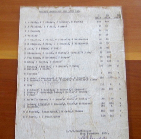 Geelong Cycling Club
Handicap Sheet, 28/11/1934
A handicapping system is part of the competitive cycling race scene. The handicap system was used for 1 mile, 1.5 mile and 5 mile races.Provides insight into handicapping of road racing and the distances raced for the cyclists during the 1930s.Typewritten page of race handicaps for the GWCC members on 15/12/1934, signed off by the official handicapper on 28/11/1934.geelong cycling club; geelong west cycling club; gwcc; handicaps; 1930s; -
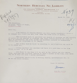 Federation University Historical Collection
Letter, Letter from Northern Hercules No Liability to the Ballarat School of Mines, 28/03/1957
Many mining companies sought staff from the Ballarat School of Mines.Typed letter on Northern Hercules No Liability letterhead asking for a qualified assayer to work at the Pine Creek Gold Mine 160 miles south of Darwin. The letter was responded to by R.W. Richards, Principal of the Ballarat School of Minesballarat school of mines, northern hurcules no liability, northern territory, mining, letterhead, r.w. richards, dick richards, mining companies, assayer