Showing 733 items matching "aerial photo"
-
 Glenelg Shire Council Cultural Collection
Photograph - Photograph - Portland Harbour, c. 1950
... Black and white aerial photo of Portland Harbour showing... and white aerial photo of Portland Harbour showing Fishermen's ...Port of Portland Authority Archivesport of portland archives, portland harbour -
Glenelg Shire Council Cultural Collection
Photograph - Photograph - Cape Grant Quarry, Portland, n.d
... Black and white aerial photo of Cape Grant Quarry. Several... Portland Harbour Cape Grant Quarry Black and white aerial photo ...Port of Portland Authority Archivesport of portland archives, aerial photography, portland harbour, cape grant quarry -
Port Melbourne Historical & Preservation Society
Photograph - Aerial view of HMS Repulse with tug James Patterson passing Williamstown, Royal Australian Air Force (RAAF), 1924
... Air Force aerial photos of the visit of HMS Hood and HMS... hms hood hms repulse ss james patterson Air Force aerial ...Air Force aerial photos of the visit of HMS Hood and HMS Repulse 1924 02 - HMS Repulse passing Williamstown with the tug James Pattersonpiers and wharves - princes pier, transport - shipping, armed services - navy, hms hood, hms repulse, ss james patterson -
Whitehorse Historical Society Inc.
Letter - Correspondence, Mullum Mullum Park, 1/11/2006 12:00:00 AM
... the formation of the new Mullum Mullum Park; aerial photo of the area... of the new Mullum Mullum Park; aerial photo of the area on verso ...Letter from Tony Robinson, MP to RC & BJ Gardiner about the formation of the new Mullum Mullum Park; aerial photo of the area on verso.Letter from Tony Robinson, MP to RC & BJ Gardiner about the formation of the new Mullum Mullum Park; aerial photo of the area on verso.Letter from Tony Robinson, MP to RC & BJ Gardiner about the formation of the new Mullum Mullum Park; aerial photo of the area on verso.mullum mullum park, tony robinson -
Glenelg Shire Council Cultural Collection
Souvenir - 'Back to Portland' souvenir program, E. Davis and Sons Pty Ltd, Portland, Vic, Back to Portland 1981, 1981
... at Portland. Back cover - aerial photo of the port.... cover - aerial photo of the port. Back to Portland 1981 Souvenir ...1981 'Back to' Portland souvenir program. 12 pages, cardboard cover, white; image of the landing of the Hentys at Portland. Back cover - aerial photo of the port.portland, 1981, 1980s -
Glenelg Shire Council Cultural Collection
Photograph - Photograph - Portland Harbour, n.d
... Black & white aerial photo showing part of KS Anderson... & white aerial photo showing part of KS Anderson wharf, silos ...Port of Portland Authority Archivesport of portland archives, portland harbour -
Glenelg Shire Council Cultural Collection
Photograph - Photograph - Portland Harbour, n.d
... Black and white aerial photo showing part of K.S Anderson... and white aerial photo showing part of K.S Anderson Wharf, Silos ...Port of Portland Authority ArchivesBack: harb016 - pencilport of portland archives, k s anderson wharf, silos, lee breakwater, ocean pier -
Port Melbourne Historical & Preservation Society
Photograph - Aerial view of the commencement of Appleton Dock, Aug 1925
... Black and white aerial photo of Commencement of Appleton... Black and white aerial photo of Commencement of Appleton Dock ...Black and white aerial photo of Commencement of Appleton Dock and construction of new river berths, with caption, both pasted onto paper with chequered computer bordertransport - shipping, piers and wharves, yarra river, appleton dock -
Port Melbourne Historical & Preservation Society
Photograph - Aerial view of American destroyers at Victoria Dock, 6 Aug 1925
... Copy of aerial photo of Victoria Dock 1925 with destroyers... Copy of aerial photo of Victoria Dock 1925 with destroyers from ...Copy of aerial photo of Victoria Dock 1925 with destroyers from visiting American fleet, with caption, both pasted onto paper with chequered computer bordertransport - shipping, piers and wharves - miscellaneous, victoria dock -
 Tatura Irrigation & Wartime Camps Museum
Photograph, Tatura Research Station
... First office of the Tatura Research Station.|Aerial photo....|Aerial photo of Research Institute 2000. Tatura Research Station ...First office of the Tatura Research Station.|Aerial photo of Research Institute 2000. -
Glenelg Shire Council Cultural Collection
Photograph - Photograph - Cape Grant Quarry, 24/01/1968
... Black and white photo aerial photo of Cape Grant quarry...: 'JAN 24, 1968' - pencil top right Black and white photo aerial ...Port of Portland Authority archives.Back: 'JAN 24, 1968' - pencil top rightport of portland archives, cape grant quarry -
Glenelg Shire Council Cultural Collection
Photograph - Photograph - aerial view of Portland Harbour, n.d
... Black &white aerial photo of Portland Harbour, also showing... Portland Harbour Black &white aerial photo of Portland Harbour ...Port of Portland Authority Archivesport of portland archives, aerial photography, portland harbour -
Glenelg Shire Council Cultural Collection
Photograph, Photograph - Reclamation and Canal Work, 1959
... Black and white aerial photo showing land reclamation... and white aerial photo showing land reclamation and canal work ...Port of Portland Authority ArchivesBack: 1959 - black biroport of portland -
Glenelg Shire Council Cultural Collection
Photograph - Photograph - Portland Harbour, Main Breakwater Construction, n.d
... Black and white aerial photo of land reclamtion, wharf... wharf Battery Point Black and white aerial photo of land ...Port of Portland Authority Archivesport of portland archives, harbour construction, wharf, battery point -
 Whitehorse Historical Society Inc.
Map, Photo-map Ringwood A4A, 1945
... Aerial photo covering approximately from Box Hill... forest hill mitcham Aerial photo covering approximately from Box ...Aerial photo covering approximately from Box Hill to Mitcham (West to East) and Springfield Road to Hawthorn Road (North to south).Aerial photo covering approximately from Box Hill to Mitcham (West to East) and Springfield Road to Hawthorn Road (North to south). Names of main roads inscribed.Aerial photo covering approximately from Box Hill to Mitcham (West to East) and Springfield Road to Hawthorn Road (North to south).aerial photographs, box hill, blackburn, nunawading, forest hill, mitcham -
 Bendigo Military Museum
Booklet - COLLECTION OF PHOTOS AFTER PEARL HARBOUR BOMBING, 1941
... This is a compendium of ground level and aerial photos... of first photo is:- "Received these photos from an old shipmate ...Item is part of the BCOF Association collection, refer Cat No 7625.This is a compendium of ground level and aerial photos of bomb damaged Pearl Harbour. Each photo, black and white, size about 14.5 x 18.5. They are contained in a plastic folder.Typed on top of first photo is:- "Received these photos from an old shipmate on the USS QUAPAW ATF-110. Interesting as I have never seen them anywhere else. I think they are spectacular." Pearl Harbour December 7th 1941.ww2, pearl harbour, copes of photographs -
 Phillip Island and District Historical Society Inc.
Newspaper clippings, 22/02/1967
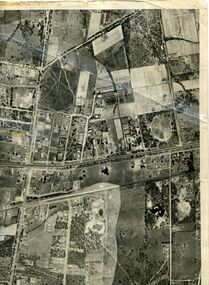
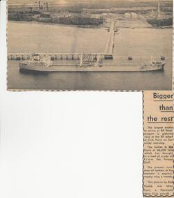
... at that time. Aerial photo of the tanker at Crib Point Jetty.... at that time. Aerial photo of the tanker at Crib Point Jetty. Newspaper ...Collection of newspaper clippers in scrap book dated 1960 - 1973Article re the tanker, "Esyra" arriving at Crib Point refinery with Persian Gulf oil. The largest tanker to arrive at that time. Aerial photo of the tanker at Crib Point Jetty.local history, newspapers, westernport oil installation, arrival of tanker "esyra", crib point, jean jamieson -
Port Melbourne Historical & Preservation Society
Photograph - Aerial view of Port Melbourne, c. 1990
... Map and aerial photo of Port Melbourne with handwritten.... fishermans bend Map and aerial photo of Port Melbourne ...Notations made as a result of conversations Anne had in the early 1990's with an elderly male resident of Port Melbourne.Map and aerial photo of Port Melbourne with handwritten annotations detailing the location of various buildings, trotting tracks, etc which previously existed in Port Melbourne (recollections only).fishermans bend -
Tatura Irrigation & Wartime Camps Museum
Photos
... ) in Casey Street, aerial photos and staff at opening.... School) in Casey Street, aerial photos and staff at opening ...Borrowed photos of building of Goulburn Murray Water Offices c.1990. Includes original site (Tatura State School) in Casey Street, aerial photos and staff at opening. -
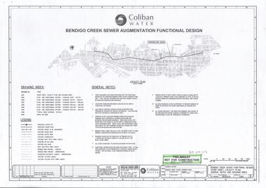 Bendigo Historical Society Inc.
Document - COLIBAN WATER - BENDIGO CREEK SEWER AUGMANTATION FUNCTIONAL DESIGN
... eight aerial photos of the area.... dated 29/08/2003. Also eight aerial photos of the area. Document ...Design for Coliban Water proposed new sewer. Bendigo creek sewer augmentation functional design dated 29/08/2003. Also eight aerial photos of the area.bendigo, business, coliban water -
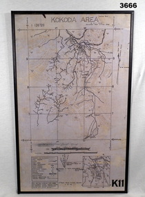 Bendigo Military Museum
Map - MAP, KOKODA MOUNTED, 2nd Aust Field Survey Section, 4.9.1942
... Map was compiled from aerial photos without ground control... goldfields Map was compiled from aerial photos without ground control ...Map was compiled from aerial photos without ground control or inspection & with information received from Major CAMERON.Laminated map of Kokoda area on board backing with black border. Black printing on cream / fawn background. White hanging strap on back. Information ledger bottom LHS. Kokoda inset bottom RHS.Printed at top: “KOKODA AREA” Printed at bottom “RHS: K11”map, kokoda, mounted -
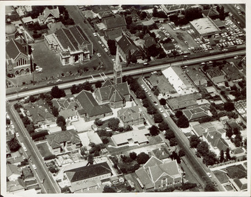 Kew Historical Society Inc
Photograph - Aerial photograph of Cotham Road and Highbury Grove, Kew, c.1970
... This aerial photo was used by John O'Neill in The Church...This aerial photo was used by John O'Neill in The Church ...This aerial photo was used by John O'Neill in The Church on the Hill, published 1974, so the photo predates that. The photographer is unknown.Black and white aerial photograph of the intersection of Cotham Road and Highbury Grove in Kew, looking south. This historically important photo shows major churches and schools in the vicinity, including a number that have since been demolished. Bordering St John''s Parade at the top of the photo are, on the left Sacred Heart Church and Primary School, while on the right are the original buildings of the Kew Baptist Church, beside which is Bib Stilwell's caryard and the remains of Alice Anderson's garage. In the foreground is the new Baptist Church and on Cotham Road, the Kew Presbyterian Church.Nilcotham. road -- kew, highbury grove -- kew, mary street -- kew, st john's parade -- kew, alice anderson, bib stilwell, kew baptist church, kew presbyterian church, sacred heart church – kew (vic.), sacred heart primary school – kew (vic.) -
Glenelg Shire Council Cultural Collection
Photograph - Photograph - aerial view of Portland HArbour, n.d
... Black & white aerial photo of KS Anderson wharf area... aerial photo of KS Anderson wharf area showing construction ...Port of Portland Authority ArchivesBack: harb005 - pencil, bottom rightport of portland archives, aerial photography, portland harbour -
Glenelg Shire Council Cultural Collection
Photograph - Photograph - aerial view of Henty Beach, Portland, n.d
... Black and white aerial photo showing marina front left... Black and white aerial photo showing marina front left. Henty ...Port of Portland Authority ArchivesBack: rd011 - pencilport of portland archives, aerial photography, portland harbour, henty beach, bathing boxes -
Glenelg Shire Council Cultural Collection
Photograph - Photograph - aerial view of Portland Harbour, n.d
... Black & white aerial photo of Portland Harbour, showing SL... Portland Harbour K S Anderson Wharf Black & white aerial photo ...Port of Portland Authority Archivesport of portland archives, aerial photography, portland harbour, k s anderson wharf -
Glenelg Shire Council Cultural Collection
Photograph - Photograph - Main Breakwater construction, Portland, n.d
... Black and white aerial photo, taken from east side of main... development main breakwater Black and white aerial photo, taken from ...Port of Portland Authority Archivesport of portland archives, harbour construction, development, main breakwater -
Glenelg Shire Council Cultural Collection
Photograph - Photograph - Lee Breakwater, Portland, n.d
... Black & white aerial photo of Portland Harbour, looking... Breakwater Ocean Pier Railway Pier construction Black & white aerial ...Port of Portland Authority Archivesport of portland archives, portland harbour, lee breakwater, ocean pier, railway pier, construction -
Glenelg Shire Council Cultural Collection
Photograph - Photograph - Cape GRant Quarry, Portland, n.d
... Black and white aerial photo of Cape Grant quarry looking... harbour development Black and white aerial photo of Cape Grant ...Port of Portland Authority Archivesport of portland archives, cape grant quarry, harbour development -
 Port Melbourne Historical & Preservation Society
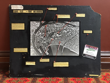
Mixed media, Robert Frost, Toxic Flat - Port Melbourne, 1987
... information connected by string to points on an aerial photo of Port... on an aerial photo of Port Melbourne/Fishermen's Bend; indicates ...Produced by Robert Frost of Alfred Street for use in Bay Street informational stalls by Port Melbourne 'Residents' Picket Group' against the SCDC Bayside development, 1988Large black display board with captions of environmental information connected by string to points on an aerial photo of Port Melbourne/Fishermen's Bend; indicates sources of contamination in Port Melbourne and on the bend.public action campaigns, environmental issues, town planning - proposals shelved - bayside, fishermans bend, industry - manufacturing, robert frost, residents picket group, british petroleum group, elders ixl, glazebrook paints, csiro, state electricity commission -
Port Melbourne Historical & Preservation Society
Photograph - Aerial view of Port Melbourne, overlaid, Charter Keck, Cramer, Nov 2006
... Black and White aerial photo with red map overlay, labelled... authority Black and White aerial photo with red map overlay ...Black and White aerial photo with red map overlay, labelled "Port Melbourne 1946 overlaid" in gold/brown metal frame . Shows Yarra River, Coode Canal and Hobson's Bay.built environment - industrial, engineering - canals and drainage, coode island, yarra river, melbourne harbor trust - port of melbourne authority