Showing 762 items
matching aerial views
-
 Phillip Island and District Historical Society Inc.
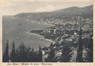
Photograph, 1950
... aerial view - coastal view - san remo europe...Aerial view of San Remo coastline with row of various Pine...-island-and-the-bass-coast Photograph Aerial view of San Remo ...Personal communication from Europe to relative (Aunt Elsie) in San Remo dated 17/06/1951Aerial view of San Remo coastline with row of various Pine Trees across foreground. Hills in background. Pier at top left. Shows town area of San Remo in Italy, Europe.San Remo - Riviera Dei Fiori - Panoramaphotography, photographs, aerial view - coastal view - san remo europe, black & white photograph, comparison views san remo, aerial -
 Churchill Island Heritage Farm
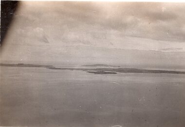
Distant Aerial View of Churchill Island, c.1940
... Distant Aerial View of Churchill Island...Black and White Photograph showing an aerial view... Churchill Island Churchill Island gippsland Distant Aerial View ...Churchill Island Heritage Farm has a large photograph collection dating from the mid-nineteenth century to the last decade. Black and White Photograph showing an aerial view of Churchill Island and Phillip Island in the distance. An underexposed part occludes part of the top/left frame, potentially showing a plane door/windowCatalogue number written in pencil on the reverse. 'S19' written in pencil on the reverse 'KODAK PRINT' stamped on reverse. 'VELOX' stamped diagonally on reversechurchill island, aerial photography -
 Whitehorse Historical Society Inc.
Photograph, Aerial View - Eastbridge Hostel, 1953
... Aerial View - Eastbridge Hostel...Black and white Aerial View of Eastbridge Migrant Hostel... Mitcham melbourne Photograph Photograph Aerial View - Eastbridge ...Black and white Aerial View of Eastbridge Migrant Hostel in Rooks Road, Nunawading (since demolished) taken in 1953. Donor's Family was first Family in Eastbridge and Donor was Housekeeper there for 2 years.jones, mrs, eastbridge migrant hostel -
 Glenelg Shire Council Cultural Collection
Photograph - Photograph - aerial view of Port of Portland, c. 1974
... Photograph - aerial view of Port of Portland...Black and white photograph, aerial view taken from... Cliff Street Portland great-ocean-road Photograph - aerial view ...Port of Portland Authority archives.Front: (no inscriptions) Back: (no inscriptions)port of portland archives, aerial photography, portland harbour, k s anderson wharf, s l patterson wharf -
Glenelg Shire Council Cultural Collection
Photograph - Photograph - Main Breakwater Construction, n.d
... Black and white aerial view of main breakwater, taken... Breakwater Construction Photograph Black and white aerial view ...Port of Portland Authority Archivesport of portland archives, portland harbour, ship berthed, ocean pier, lee breakwater -
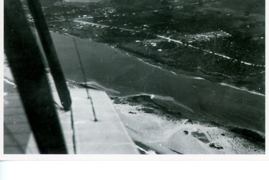
 Phillip Island and District Historical Society Inc.
Photograph, San Remo & Phillip Island, 1940's
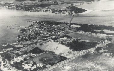
... Aerial view of first Phillip Island Suspension Bridge... bridge from Newhaven, showing San Remo. Aerial view of first ...Aerial view of first Phillip Island Suspension Bridge completed in 1940 and opend by Hon. Albert Dunstan MLA, Premier of Victoria.Aerial photograph of Mainland and Phillip Island with connecting bridge from Newhaven, showing San Remo.local history, photographs, civil engineering, bridges, phillip island bridge, black & white photograph, jack jenner collection, phillip island bridges, public construction -
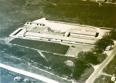
Stawell Historical Society Inc
Photograph, Pleasant Creek Training Centre -- Aerial View
... Pleasant Creek Training Centre -- Aerial View...Framed Aerial view of Pleasant Creek Training Centre...Photograph Pleasant Creek Training Centre -- Aerial View ...Framed Aerial view of Pleasant Creek Training Centre Referred to as Pleasant Creek Training Centre or Pleasant Creek Special Schoolstawell -
 Federation University Historical Collection
Photograph - Photograph - Black and White, Aerial View of Federation University SMB Campus, c1967
... Aerial View of Federation University SMB Campus...Black and white photograph showing an aerial View... Photograph - Black and White Photograph Aerial View of Federation ...This photograph was taken around the time that the Ballarat School of Mines obtained the Former Ballarat Gaol site and the Ballarat Brewery site.Black and white photograph showing an aerial View of Federation University SMB Campus. The image shows the former Ballarat Gaol (now demolished), Ballarat Brewery, (now demolished) and White Flat Oval.ballarat school of mines, ballarat gaol, ballarat brewery, white flat, ballarat townscape, smb campus, ballarat school of mines campus, lydiard street, aerial -
Glenelg Shire Council Cultural Collection
Photograph - Photograph - Aerial view from N.W. Port of Portland, 05/03/1971
... Photograph - Aerial view from N.W. Port of Portland...b x w photograph - unframed. Aerial view from N.W. Port... Cliff Street Portland great-ocean-road Photograph - Aerial view ...Port of Portland Authority archives.Front: (no inscriptions) Back: (no inscriptions)port of portland archives, portland harbour -
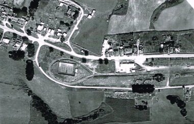 Otway Districts Historical Society
Photograph, R. Preston, Aerial view of Beech Forest railway station and yards, 1965, 13 February 1965
... Aerial view of Beech Forest railway station and yards, 1965....B/W. An aerial view of Beech Forest showing the balloon... Forest great-ocean-road Photograph Aerial view of Beech Forest ...B/W. An aerial view of Beech Forest showing the balloon loop at the end of the station yard (enclosing the two tennis courts), two ex-departmental residences, the station buildings, and other aspects of the township.beech forest: railways; township; aerial; -
 Whitehorse Historical Society Inc.
Photograph, Aerial View of Mitcham, C.1925
... Aerial View of Mitcham...Large Aerial View of Mitcham showing Railway and South side... Mitcham melbourne Photograph Photograph Aerial View of Mitcham ...Large Aerial View of Mitcham showing Railway and South side. In particular, The Australian Tesselated Tile Co. Works and Quarry. Also Monarch Works, better known as Builders' Trade and Roofing Co. and their Quarry.australian tesselated tile co. pty ltd, aerial photographs, monarch pottery, builders trading and roofing co. ltd -
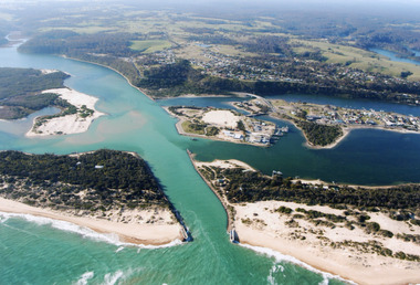
 Lakes Entrance Regional Historical Society (operating as Lakes Entrance History Centre & Museum)
Photograph, Kruger A F, 1960c
... Colour photograph aerial view of the entrance from Bass... Colour photograph aerial view of the entrance from Bass Strait ...Colour photograph aerial view of the entrance from Bass Strait to the Gippsland Lakes, Australia. Shows extension to Bullock Island, town of Lakes Entrance, Cunninghame Arm and North Arm. Lakes Entrance Victoriaaerial photograph, islands, waterways, topography -
Stawell Historical Society Inc
Photograph, Stawell Aerial View Centred on Town Hall in Main Street 1998 -- Coloured
... Stawell Aerial View Centred on Town Hall in Main Street...Colour Aerial View of Stawell 1998 Centred on Town Hall... grampians Photograph Stawell Aerial View Centred on Town Hall ...Colour Aerial View of Stawell 1998 Centred on Town Hall. Main Street. Scallan Street Childe Street Houston Street and Ligar Street.stawell -
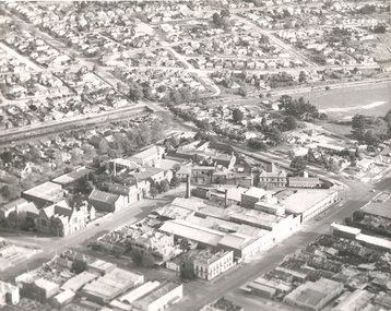
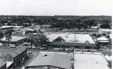
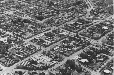 City of Ballarat Libraries
Photograph, Aerial View of the Ballarat CBD in 1957 / 1958
... Aerial View of the Ballarat CBD in 1957 / 1958....Aerial view...This aerial view of the Ballarat CBC was taken sometime... Ballarat East goldfields Photograph Photograph Aerial View ...This aerial view of the Ballarat CBC was taken sometime in 1957 or 1958. Sturt Street can be seen running from the right centre to top left.aerial view, sturt street, ballarat, central business district, cbd -
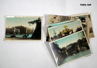 Bendigo Military Museum
Photograph - PHOTOGRAPHS, BCOF, JAPAN, possibly pre WW2
... On rear, "Scared Cam at Shinto festival" "Aerial view.... On rear, "Scared Cam at Shinto festival" "Aerial view Marunouchi ...Items in the collection re Clarence Shearing, refer Cat No 7089.16P for his service details.Series of 16 colour enhanced photos various sizes of Japan. Eight have a text on the front cover or rear. Eight are of different buildings and place.On rear, "Scared Cam at Shinto festival" "Aerial view Marunouchi the business centre of Tokyo" "Akamon (entrance) of Imperial Palace" On rear, "Entrance to Palace Tokyo" "Bridge Mijyubashi in Tokyo" "-abukiza (Theatre)"photographs, bcof, japan -
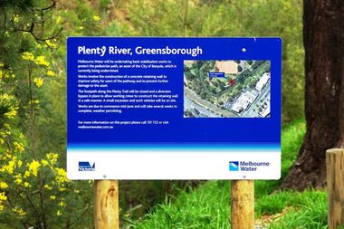 Greensborough Historical Society
Photograph - Digital image, Marilyn Smith, Plenty River bank stabilisation 2015, 16/08/2015
... -up of aerial view of site....-up of aerial view of site. plenty river melbourne water ...River bank stabilisation project along the Plenty River at Greensborough 2015, conducted by Melbourne Water. Project sign and close-up of aerial view of site.Digital copy of colour photographplenty river, melbourne water -
Glenelg Shire Council Cultural Collection
Souvenir - Tourism Booklet - 'Discovering Portland', Discovering Portland, n.d
... White. Glossy heavy card covers, lighthouse on front, aerial... covers, lighthouse on front, aerial view of Portland Island ...Thirteen page booklet 'Discovering Portland', by Carol White. Glossy heavy card covers, lighthouse on front, aerial view of Portland Island, Dorset, UK on back. Coloured photos and descriptions of places of interest on Portland. -
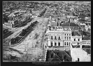
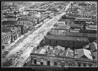 Ballarat Tramway Museum
Photograph - Black & White copy, William Bardell, "Ballarat looking north west from the Town Hall ca 1872"
... Black & White copy photograph aerial view A4 size, titled... copy photograph aerial view A4 size, titled ""Ballarat looking ...Original photograph by William Bardwell, with the original image held by the State Library of Victoria. Edited by Richard Conn. Purchased by the Museum.Provides information about the appearance of Armstrong St from the Town Hall. Shows the topography of the area, along with many buildings, including W Milne & Cp and J N Healy in the Hall of Commerce and Doig & Co, Plumbers and Gasfitters.Black & White copy photograph aerial view A4 size, titled ""Ballarat looking north west from the Town Hall ca 1872" looking along Armstrong St. Original photo by William Bardwell.ballarat, armstrong st, w milne & co, doig&co, j n healy -
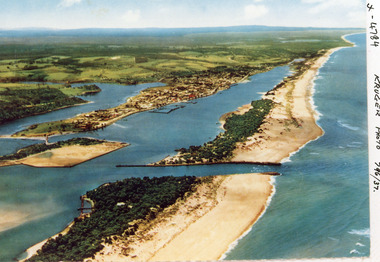
 Lakes Entrance Regional Historical Society (operating as Lakes Entrance History Centre & Museum)
Photograph, 2000
... Colour photograph of aerial view of the entrance at Lakes... photograph of aerial view of the entrance at Lakes Entrance, shows ...Colour photograph of aerial view of the entrance at Lakes Entrance, shows part of Rigby Island, Bullock Island, North Arm, Cunninghame Arm and buildup of sand on ocean shores of sand hummocks. Lakes Entrance Victoriahouses, ocean, navigation, waterways -
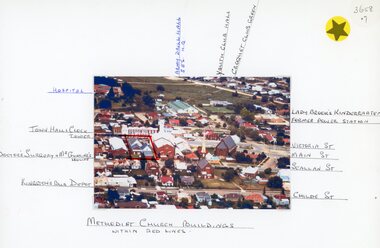 Stawell Historical Society Inc
Photograph, Stawell Methodist Church in Main Street Stawell -- Aerial View showing other buildings as well c1980
... Stawell Methodist Church in Main Street Stawell -- Aerial...Stawell Methodist Church. Main Street Stawell. Aerial View...Stawell Methodist Church. Main Street Stawell. Aerial View ...Stawell Methodist Church. Main Street Stawell. Aerial View. Shows Croquet Green. Kingston's Bus Depot. Doctors Surgery Mr Gunning's House. C1980stawell -
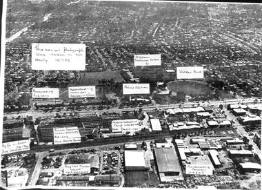
Bendigo Historical Society Inc.
Photograph - FORTUNA COLLECTION: AERIAL VIEW OF BENDIGO 1963
... FORTUNA COLLECTION: AERIAL VIEW OF BENDIGO 1963...Black and white photograph, aerial view of Bendigo 1963... Black and white photograph, aerial view of Bendigo 1963, Fortuna ...Black and white photograph, aerial view of Bendigo 1963, Fortuna Villa in foreground. On bottom of photograph ' Fortuna, an aerial view of Bendigo Circa 1963' Fortuna Villa in foregound of image, showing very clear detail of grounds. Image has labels of following sites: Lansell's 222 mine Lazarus mine site Central Red, White and Bluye mine site, Old Chum mine site New Chum and Victoria mine site West End Hall Mount Alvernia BCV8 QEO -
 City of Ballarat Libraries
Photograph - Card Box Photographs, Ballarat East High School circa 1965
... Aerial view of the Ballarat East High School on the corner... East High School circa 1965 Aerial view of the Ballarat East ...Aerial view of the Ballarat East High School on the corner of Melbourne Road (now Ballarat - Burrumbeet Rd) and Fussell Street. The campus is now the Woodman's Hill Secondary College.ballarat east high school, woodman's hill secondary college, education, building, public -
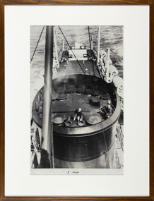 Mission to Seafarers Victoria
Photograph - Reproduction, Black and white, Mission to Seafarers Victoria, 3" Deep, c. 2009
... of photograph from the archive depicting an aerial view of the funnel... the archive depicting an aerial view of the funnel of a ship. A crew ...This photograph is part of reproductions of images from the MTS archive collection. Framed and mounted black and white reproduction of photograph from the archive depicting an aerial view of the funnel of a ship. A crew member is checking something on the funnel. In the background we can see 4 men playing tennis on the deck3" Deepmission to seafarers, mission to seamen, flinders street, melbourne, seafarers, seamen, padre oliver, crew, ships, seafaring life, sailors, funnel, ship, tennis, early origins, 2016, life onboard -
 Lakes Entrance Regional Historical Society (operating as Lakes Entrance History Centre & Museum)
Photograph, Bulmer H D, 1940c
... Black and white copy photograph of aerial view of eastern... photograph of aerial view of eastern approach, showing Princes ...Black and white copy photograph of aerial view of eastern approach, showing Princes Highway, Whiter's Camp Park, sandy outer barrier beside Cunninghame Arm, distant view of North Arm. Lakes Entrance Victoriawaterways, vegetation -
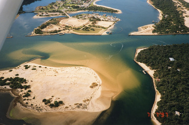
 Lakes Entrance Regional Historical Society (operating as Lakes Entrance History Centre & Museum)
Photograph, 1997
... Colour photograph being an aerial view of the western end... being an aerial view of the western end of Cunninghame Arm ...Date made 7 July 1997Colour photograph being an aerial view of the western end of Cunninghame Arm, showing the entrance between the hummocks, Bullock Island, entrance to North Arm, Snake Island surrounded by sand build-up. Lakes Entrance Victoriatopography, waterways, aerial photograph, boats and boating, township -
 Bendigo Historical Society Inc.
Photograph - AERIAL VIEW BENDIGO, 1995
... AERIAL VIEW BENDIGO...Aerial view of bendigo...Black and white photo: aerial view Mollison St., Jewel... PLACE Aerial view of bendigo Peter Hyett Black and white photo ...Black and white photo: aerial view Mollison St., Jewel Shopping complex ( Noelene Wild 7/2000 ) from St. Paul's tower ? Mollison St. left to right foreground. 'B22A' black lead on rear.Peter Hyettplace, aerial view of bendigo -
 Ballarat Tramway Museum
Photograph - Black & White copy, William Bardwell, "Ballarat looking east from the Town Hall ca 1872"
... Black & White copy photograph aerial view A4 size, titled... St Black & White copy photograph aerial view A4 size, titled ...Original photograph by William Bardwell, with the original image held by the State Library of Victoria. Edited by Richard Conn. Purchased by the Museum.Provides information about the appearance of Sturt St Ballarat, looking from the Town Hall. Shows the topography of the area, along with many buildings, including the London Chartered Bank of Australia (later the Commonwealth Bank), the Unicorn Hotel, J. Dodds Bucks Head Hotel, road works in Bridge St, Albion House Drapery, Bryce & Chalmers Produced Merchants, a fenced central median strip and two horse-drawn carriages parked in Lydiard St.Black & White copy photograph aerial view A4 size, titled ""Ballarat looking east from the Town Hall ca 1872" looking along Sturt St towards Grenville St. Original photo by William Bardwell.ballarat, sturt st, grenville st, lydiard st, bucks head hotel, bryce & chalmers, london chartered bank, albion house, bridge st -
 Lakes Entrance Regional Historical Society (operating as Lakes Entrance History Centre & Museum)
Photograph, Bulmer H D, 1923c
... Black and white photograph showing aerial view... Entrance gippsland Second copy Waterways Islands Aerial Photograph ...Second copyBlack and white photograph showing aerial view of the entrance to the Gippsland Lakes, shows Cunninghame Arm, North Arm, Reeves River and Hopetoun Channel, Rigby Island and Snake Island, the barrier on right foreground. Lakes Entrance Victoriawaterways, islands, aerial photograph, fishing industry, coast -
 Lakes Entrance Regional Historical Society (operating as Lakes Entrance History Centre & Museum)
Photograph, 1997
... Colour photograph being an aerial view of entrance at Lakes... Islands Boats and Boating Colour photograph being an aerial view ...Date made 7 July 1997Colour photograph being an aerial view of entrance at Lakes Entrance, showing the sand hummocks, the sand bar offshore a fishing boat entering the channel through the bar which appears to be recently dredged township of Lakes Entrance Victoriafishing industry, waterways, islands, boats and boating -
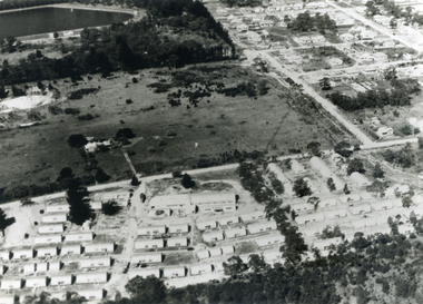
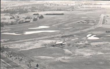 Hume City Civic Collection
Photograph
... A black and white aerial photograph of an aerial view... of an aerial view of the newly established Goonawarra Golf Club ...A black and white aerial photograph of an aerial view of the newly established Goonawarra Golf Club. Sunbury Road is visible in the bottom LH corner and Francis Avenue crosses the photograph. The clubhouse is in the centre of the photograph and some early housing development is in the distance.goonawarra gold club, housing developments, regional newspaper, george evans collection