Showing 8918 items
matching ah-15
-
 Eltham District Historical Society Inc
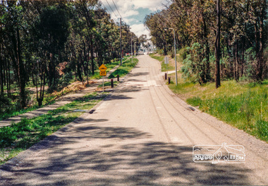
Photograph, Diosma Road, Eltham, 15 October 1990, 15/10/1990
Colour photographinfrastructure, shire of eltham, streets, diosma road, eltham, stokes orchard estate -
 Eltham District Historical Society Inc
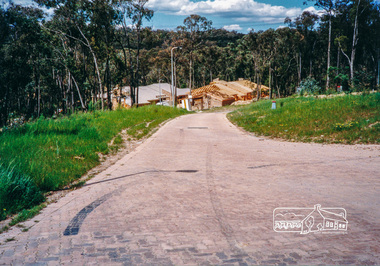
Photograph, Looking east along Sunray Court to intersection with Gum Hill Court, Eltham, 15 October 1990, 15/10/1990
Colour photographinfrastructure, shire of eltham, streets, eltham, gum hill court, sunray court -
 Federation University Historical Collection
Newspaper, British Mouthpiece, British Mouthpiece, 15 October 1960, 15 October 1960
Frank Wright was a renown resident of Smeaton, where he was born on 2 August 1901. He lived at Laura Villa, and attended Smeaton State School. His father William was a gold miner and his mother's name was Sarah. Their family won many singing and instrumental awards. Frank was tutored by Percy Code and was awarded a gold medal for the highest marks in the ALCM examinations in the British Colonies at the age of seventeen years. He became the Australian Open Cornet Champion by the age of eighteen. A year later, Frank conducted the City of Ballarat Band, and later the Ballarat Soldiers’ Memorial Band. He formed the Frank Wright Frisco Band and Frank Wright and his Coliseum Orchestra. These bands won many South Street awards, and Frank as conductor won many awards in the Australian Band Championship contest. In 1933 Frank Wright sailed to England to conduct the famous St Hilda’s Band and was later appointed Musical Director of the London County Council, where he organized many amazing concerts in parks, in and around the London district. He was made Professor of Brass and Military Band Scoring and conducted at the Guildhall of Music and Drama. Frank was often invited to adjudicate Brass Band Championships around Europe, in Australia, including South Street and in New Zealand. The Frank Wright Medal at the Royal South Street competition is awarded to an individual recognized as making an outstanding contribution to brass music in Australia.A small 12 page newspaper. On page 6 is an article on Frank Wright who was to receive that year's 'Spotlight on Service' at the National Brass Band Championship Festival. He was to conduct the assembled massed bands and was to be presented with a special 'baton of Honour'. He was also mentioned on page 12 in 'Harry Mortimer's Broadcast Notes' as one of the conductors.frank wright, british mouthpiece, conductor composer, baton of honour, spotlight on service -
 Australian Multicultural Community Services
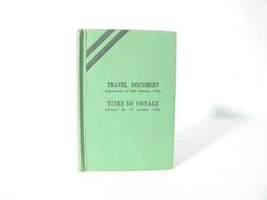
Travel Document, Travel Document (Agreement of 15th October, 1946) Titre De Voyage (Accord du 15 octobre 1946), 15/10/1946
travel document of Stanislaw (Bill) Nowak, born in Poland 14/01/1927, he came to Australia in 1951 as a refugee after II World War, this document was used instead of national passportone of a few items of this kind which has survived to present daysgreen book, contains information about Stanislaw (Bill) Nowak, document served in lieu of a national passport, issued on 15th October 1946, the holder of this document was the concern of the International Refugee Organization, this document contains 32 pages, exclusive of covermany inscriptions in relation to Stanislaw (Bill) Nowak including visas and description of personimmigration, id, travel document, bill nowak -
 Ringwood and District Historical Society
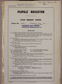
Administrative record, Ringwood East State School No 4180-Pupil Register (Book 15 of 15). Feb 1990 - Aug 1993 . Registration Numbers 9001 to 9347
Ringwood East State School No 4180-Pupil Register Images. A searchable transcript of all these images can be found as a pdf in VC Record 7509. Note: For a high resolution copy of one or more images, contact Ringwood and District Historical Society (RDHS). The original Registers are held at Public Records Victoria (PROV). Scanning of these was commissioned by RDHS and undertaken by Mark Grealy, Archival Access in 2013. (https://www.archivalaccessvictoria.com/). The registers were transcribed in 2021-2022 by Sue Breese, Archivist at RDHS. -
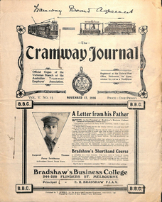 Melbourne Tram Museum
Magazine, Australian Electric Traction Association (AETA), "The tramway journal - Vol 5 No 15, November 17, 1916", 1978
Book - 12 pages centre stapled titled "The tramway journal - Vol 5 No 15, November 17, 1916". Contains the industrial agreement with the Tramway Board with new clauses marked, minimum wage decision. Has notes on the Committee of Management, The American Presidency, the Northcote cable trams, Tramway employees mortality fund, with lists of new members, members transferred or enlisted and unions in general. Includes the balance sheet of war funds subscriptions of members. Has adverts for Bradshaw's Business College, Coles book arcade, The Big Paterson furniture store, F. C Needham Optician, Carlton Ale and Abbotsford Ale and Victor Taylor dentist. Full document scanned.Has "Tramway Board Agreement" in ink along the top edge.trams, tramways, unions, agreements, world war 1, tramway board, northcote, benefit society -
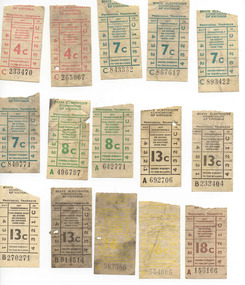 Ballarat Tramway Museum
Ephemera - Ticket/s, State Electricity Commission of Victoria (SECV), Set of 15 tickets found in a tram, late 1960's
Set of 15 mixed SEC tickets found in a tramcar being worked on at the depot c1998 (possibly No. 18 or 28), information not recorded at the time. Tickets have been used and have varying degrees of dirt. The image file shows the nature of the damage. Tickets have not been individually numbered with the Registration Number, but can be identified by their ticket number and denomination. All SEC decimal issues and all have the SEC Little boy wrapped in a towel logo on the rear: 4c - Red - C233470, C265067 7c - Green - C840774, C843332, C867617, C893422 8c - Green - A496797, A642771 13c - Black - A692706, B014514, B232404, B270271 16c- Yellow - A382386, A554006 18c - Brown - A156106trams, tramways, tickets, used tickets, secv, ballarat -
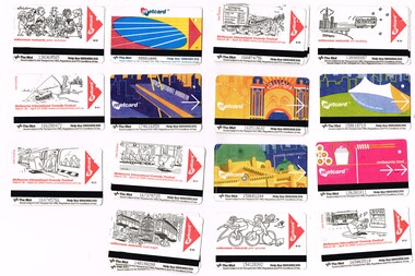 Melbourne Tram Museum
Ephemera - Ticket/s, The Met, Set of 15 Metcard tickets, 2000
Set of 15 Metcard tickets, used during the Metcard era. Has the Metcard logo on it, along with other Metcard, information. All of the tickets appear to have been used. .1 - Millennium Metcards cartoon by Ron Tandberg (3 copies) .2 - Melbourne Comedy Festival - Matt Golding cartoon - estimated travel time (3 copies) .3 - standard Metcard (3 copies) .4 - Millennium Metcards cartoon by Peter Nicholson (3 copies) .5 - Metcard featuring a stylised image of the Sidney Myer Music Bowl (3 copies) .6 - ditto of Luna Park (4 copies) .7 - ditto Melbourne Exhibition Centre (3 copies) .8 - as for 2 - but with a fish line - trolley wire - theme. ( 3 copies) .9 - featuring Melbourne food. ( see also Reg Item 1466 for the same theme) .10 - Metcard featuring a stylised image of the Flinders St Station (3 copies) .11 - Melbourne Comedy Festival - Matt Golding cartoon - Metcard Machine tapping his foot (3 copies) .12 - ditto - Metcard Machine following a passenger onto a train (3 copies) .13 - ditto - Metcard Machine and an ATM ( 3 copies) .14 - Millennium Metcard - cartoon by John Spooner (3 copies) .15 - ditto - cartoon by Mark Knight. ( 3 copies) See also Reg item 1465 for other cartoons cards. Additional copies added 3/5/16 from donation of G. Warburton - see Reg Item 1463.1 for other examples and details of donation.trams, tramways, tickets, metlink, metcard, luna park, cartoons, flinders st station -
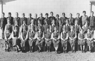 Ringwood and District Historical Society
Photograph, Ringwood High School - 1954, Form 1D. Boys standing (L-R): 1. Alan Carter, 2. David Lightfoot, 3. Maurice Henry, 4. Peter Van Ketwick, 5. Douglas Hume, 6. Alistair Wilkie, 7. John McCallum, 8. Robert Summerville, 9. Geoff Barker, 10. Ken Landy, 11. Peter Gluth, 12. Alan Richards, 13. Geoff Edwards, 14. Len Armfield, 15. Ray Davidson. Girls standing: 1. Sally Wilson, 2. Brenda Shore, 3. Jeanette Hancy, 4. Lea Boyce, 5. Carol Kennedy, 6. Joy MacDonald, 7. Diana Richards, 8. Racheal Nield, 9. Jeanette Martin, 10. Muriel Peacock, 11. Jennifer Bradley. Girls seated: 1. Barbara Tortoise, 2. Barbara Gotts, 3. Janice White, 4. Fay Clarice, 5. Wendy Pyke, 6. Moya Crane, 7. Dianne Dewer, 8. Dorothy Hunter, 9. Nola Hind, 10. Barbara Johnson, 11. Meryl Hearnes
Written on list in sleeve, "High School - Bedford Rd. Ringwood. Photo Pupils - Form 1D. Reading from Left to Right: Back row boys: 1. Alan Carter, 2. ??, 3. Maurice Henry, 4. Peter Van Ketwich, 5. Douglas Hume, 6. ??, 7. John Callam, 8. ??, 9. ??, 10. ??, 11. Peter Gluth, 12. ??, 13. Geoff Edwards, 14. Len Armfield, 15. Ray Davidson". -
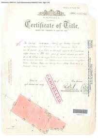 Ringwood and District Historical Society
Document, Certificate of Title - Crown Sections 12, 15, and Part of Section 20 (later including Warranwood, Vic.), Parish of Warrandyte, County of Evelyn - 11 June, 1898
A4 copies of Landata Victoria Historical Search documents - Vol 2687 Fol 537231.The Mutual Assurance Society of Victoria Limited of 406 Collins Street Melbourne, County of Bourke, is now the proprietor of an Estate in Fee-simple - 1,640 acres 3 roods 31 perches or thereabouts, being Crown Sections 12, 15, and part of Crown Section 20, Parish of Warrandyte, County of Evelyn. TRANSFER - 13th March, 1899 - 17ac 3rds 5per to The President Councellors and Ratepayers of the Shire of Lilydale (Part of Crown Section 20). -
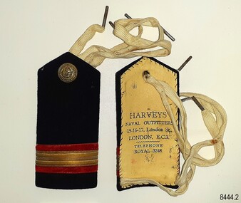 Flagstaff Hill Maritime Museum and Village
Badge - Epaulette, Harvey's Naval Outfitters, 1920s
The pair of epaulettes once belonged to W.R. Angus, who possibly wore them when he worked his passage to and from the UK in the 1920s. The button on each has an unidentified emblem. They are part of Flagstaff Hill’s comprehensive W.R. Angus Collection, donated by the family of Dr W R Angus (1901-1970), surgeon and oculist. The ties, which look like shoe laces, would secure the epaulettes to the uniform's shoulders. The epaulettes were made by Harvey's Naval Outfitters of 15-16-17 London Street, London, E.C.3, in the East Central area of London. Another of the firm's addresses is Leadenhall Street, London, named the 'centre of commerce'. East India Company and Pacific & Oriental Steam Navigation Company (P&O) once had their headquarters there. The postcode 'EC3' dates back to 1917 when the postcode system was established in the United Kingdom. William Roy Angus (1901-1970) qualified as a doctor in 1923. He decided he further his studies overseas in the UK in 1927, sailing on the ship SS Banffshire (built in 1912, destroyed in 1937). He studied at London University College Hospital and Edinburgh Royal Infirmary and in 1928 he was awarded FRCS (Fellow from the Royal College of Surgeons), Edinburgh, Scotland. He worked his passage back to Australia as a Ship’s Surgeon on the Australian Commonwealth Line T.S.S. Largs Bay, purchased by the White Star Line in 1928. Dr W R Angus was a Surgeon Captain for the Australian Defence Forces, Army Medical Corps, stationed in Ballarat, Victoria, and in Bonegilla, N.S.W. He completed his service just before the end of the war due to suffering from a heart attack. The W.R. Angus Collection: - The W.R. Angus Collection includes historical medical equipment, surgical instruments and material belonging to Dr Edward Ryan and Dr Thomas Francis Ryan, (both of Nhill, Victoria) and Dr Angus’ own belongings. The Collection’s history spans the medical practices of the two Doctors Ryan, from 1885-1926 plus that of Dr Angus, up until 1969. It includes historical medical and surgical equipment and instruments from the doctors Edward and Thomas Ryan of Nhill, Victoria. Dr Angus married Gladys in 1927 at Ballarat, the nearest big city to Nhill where he began as a Medical Assistant. He was also Acting House surgeon at the Nhill hospital where their two daughters were born. During World War II He served as a Military Doctor in the Australian Defence Forces. Dr Angus and his family moved to Warrnambool in 1939, where Dr Angus operated his own medical practice. He later added the part-time Port Medical Officer responsibility and was the last person appointed to that position. Dr Angus and his wife were very involved in the local community, including the new Flagstaff Hill's planning stages and the gardens' layout. Dr Angus passed away in March 1970.This pair of epaulettes is connected to the badges in the W.R. Angus Collection. Dr W R Angus (1901-1970), surgeon and oculist, collected a range of badges and military objects including those he personally used during his time as Surgeon Captain in the Australian Defence Forces in World War II. The W.R. Angus Collection is significant for still being located at the site it is connected with, Doctor Angus being the last Port Medical Officer in Warrnambool. The Collection includes historical medical objects that date back to the late 1800s.Epaulette (pair of two), dark blue with red and gold horizontal stripes, with a gold-coloured button and woven white web ties. A tall rectangular shape with a point at the top. Made from a card base, covered by dark blue fabric and a hand-stitched lining of cream-coloured leather, stamped with the maker's details. The button has an inscripton and image. Made by Harvey's Outfitters in London. The button has images and text. The epaulettes belonged to Dr W R Angus and are now part of the W. R. Angus Collection.“HARVEYS’ / NAVAL OUTFITTERS / 15-16-17, London St / LONDON E.C.3. / TELEPHONE / ROYAL 3248” Button; Inscription and image [indecipherable] Button is embossed with images (anchor, serpent, flag) and text "B. 'G. "flagstaff hill, warrnambool, maritime village, maritime museum, shipwreck coast, great ocean road, flagstaff hill maritime museum and village, dr w r angus, w.r. angus collection, badge, insignia, badge collection, epaulettes, naval epaulettes, naval insignia, shoulder boards, ss banffshire, t.s.s. largs bay, uniform, harvey's naval outfitters, london street london -
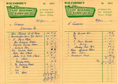 Ringwood and District Historical Society
Document - Manila Folder, Collection of personal documents for Mr Emil Goddard, 15 Eastfield Road, Ringwood East, Victoria, 1947-1953
Correspondence between Mr Goddard and Repatriation Department regarding War Pension entitlements. Specifications of work to be done and materials to be used in the erection of a timber residence at 15 Eastfield Road, Ringwood East, for E.K. Goddard. Contract of Sale of Land at Lots 55 & 56 on P/S No.10492, part of Crown allotments 27 and 28,B, Parish of Ringwood, County of Mornington. Miscellaneous receipts from 1947-1953 including Hire Purchase Agreement for Hillman Minx car. Also includes letter from Presbyterian Ladies' College referring to 1953 term 1 fee of £18.0.3 for Margaret Goddard Receipts from Wiltshire's East Ringwood Hardware, 98 Railway Avenue, East Ringwood, Phone 87-6092, 8/7/1962. -
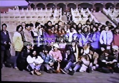 Eltham District Historical Society Inc
Film - Video (DVD), Brian Maclean, Eltham College Concert Band Tour of China 5-15 December, 1987
In 1987 (Dec. 5—Dec. 15), the Eltham College Concert Band did a tour of China. Upon return, a VHS tape was made of the tour as a memento of the occasion. Sufficient material of useable quality and content has remained to allow two DVD’s to be produced by tape to disc transfer. Disc 1 runs for 94 mins. and Disc 2 for 77 mins. Original tape ran for about three hours so not all that much has been lost. In general the video work was by Mr. Brian Maclean, year 12 Co-Ordinator at the college and is very professional for the video equipment of the day. There is a full ‘cast list’ at the end with credits for all band members and those who organised it all. Very much a school magazine of characters but a movie instead. video recording, eltham college, china tour, eltham college concert band -
 Federation University Historical Collection
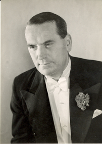
Photograph - black and white, Cyril Arnold, Frank Wright, mid 1900s
Frank Wright was a renown resident of Smeaton, where he was born on 2 August 1901. He lived at Laura Villa, and attended Smeaton State School. His father William was a gold miner and his mother's name was Sarah. Their family won many singing and instrumental awards. Frank was tutored by Percy Code and was awarded a gold medal for the highest marks in the ALCM examinations in the British Colonies at the age of seventeen years. He became the Australian Open Cornet Champion by the age of eighteen. A year later, Frank conducted the City of Ballarat Band, and later the Ballarat Soldiers’ Memorial Band. He formed the Frank Wright Frisco Band and Frank Wright and his Coliseum Orchestra. These bands won many South Street awards, and Frank as conductor won many awards in the Australian Band Championship contest. In 1933 Frank Wright sailed to England to conduct the famous St Hilda’s Band and was later appointed Musical Director of the London County Council, where he organized many amazing concerts in parks, in and around the London district. He was made Professor of Brass and Military Band Scoring and conducted at the Guildhall of Music and Drama. Frank was often invited to adjudicate Brass Band Championships around Europe, in Australia, including South Street and in New Zealand. The Frank Wright Medal at the Royal South Street competition is awarded to an individual recognized as making an outstanding contribution to brass music in Australia.Black and white studio photograph of the torso of a man dressed in a dinner suit with a carnation in the buttonhole. The man is Frank Wright.Printed on back - Photo by:- Cyril Arnold, 15 Grape St., London, W.C.2, Phone--Temple Bar 0573 Written in pen on back - 1779/cfrank wright, conductor, brass band -
 Hume City Civic Collection
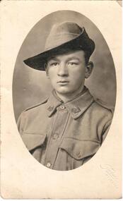
Photograph, c1914
This is a photo of George Hayes age 15 1/2 years, a member of 23rd Battalion 1st AIF ANZACA photograph of George Hayes aged 15 years, a member of the 23rd Battalion, 1st AIF.on back: George Hayes / 23rd Batt. 1st A.I. F. 15 years of age / ANZACworld war 1, soldiers, armed forces, uniforms, clothing and dress, anzac, hayes, george, george evans collection -
 Surrey Hills Historical Society Collection
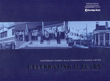
Book, Canterbury Surrey Hills Community Finance Limited: Celebrating 15 Years and $5.6 Million back to the community, 2018
This book celebrates the achievements of the Bendigo Community Bank after 15 years in Surrey Hills and Canterbury. The Surrey Hills branch was opened in the bank site previously operated by the CBA (Commonwealth Bank of Australia) after it took over the State Savings Bank of Victoria (SSB) which has the building constructed for bank use in 1916. A public meeting to garner support for opening a branch of the Bendigo Community Bank was held in the Surrey Hills Neighbourhood Centre. One of those pushing for restoration of banking services in the area was Damien Hudson, son of real estate agent Ray Hudson. He subsequently became a member of the Surrey Hills Community Bank Board. Dick Menting, who was the local Councillor at the time, was another key supporter who likewise became a board member as did Bob Stensholt, the MLA for Burwood .Hard covered book, H 23.2 cm , 71 pages, incl index(ms) jennifer flynn, bendigo bank, canterbury surrey hills community finance, community banking, (mr) damien hudson, (cr) dick menting, (mr) bob stensholt -
Glen Eira Historical Society
Document - Gisborne Street, 15, Elsternwick
A one page research report by the Brighton Historical Society, dated 19/04/1988 on 15 Gisborne Street, Elsternwick, previously 8 Gisborne Street. The report provides a brief history of the property and includes a list of residents from 1892 to 1974. The file also includes one page of handwritten, undated and unattributed working notes relating to 15 Gisborne Street, Elsternwick.gisborne street, elsternwick, carre-riddell john, riddell’s creek, moore john, mcclenagham d, williams evelyn, herwig august w, herwig l u, leeming l u, bullocks hilary, landells rosalind, jenkins mary ann, houses -
Glen Eira Historical Society
Article - Villiers Street, 15, Elsternwick
Unattributed advertising article dated 28/09/01 by Carmichael and Weber for forthcoming auction of 15 Villiers Street, Elsternwick.elsternwick, villiers street, st. georges road, architectural styles, carmichael and weber, waterton danielle, carmichael iain -
 Melbourne Tram Museum
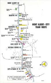
Map, Melbourne & Metropolitan Tramways Board (MMTB), Set of 15 tram route maps, 1977 to 1979
Series of 15 colour route maps for various tram lines or groups of tram lines for the MMTB. Some have the Transport Information Centre telephone printed on them, others have a label stuck on. Some are finished with a plastic laminate finish on either one or both sides. Show the major cross streets, parks, schools, other tram routes, major stop numbers and railway lines. Two copies of each held unless noted otherwise. .1 - Mont - Albert City - R11/77, shows routes 43. 47. 45. 44 .2 - Malvern, East Malvern, Carnegie and East Brighton Tram Routes (from St Kilda Junction) - R1/79 - shows routes 5, 3, 67, 66, 61, 62 and 64. .3 - Swanston St tram guide - R1/79 - lists all routes and route numbers that branch or cross Swanston St between Grattan St and St Kilda Junction. .4 - St Kilda Rd Tram Routes R12/77 - details South Melbourne Beach, route 1 and route 2 and St Kilda Beach routes 15, 16 and 55 otherwise shows were the various routes branch off St Kilda Road. Copy 1 has "P14909" in pencil in the bottom right hand corner. .5 - Kew - St Kilda Beach - R1/79 - Route 69. .6 - Footscray - Moonee Ponds - R3/81 - Route 82 .7 - Flinders St tram routes - R5/78 - North Balwyn, East Burwood, routes 48, 40, 41, Hartwell, 28, 74 and 75 .8 - William St tram routes - Route 55, 56 and 63 - South Melbourne Depot and Domain. copy 2 has "P14913" in bottom right hand corner. .9 - Toorak Camberwell and Glen Iris tram routes with Camberwell Junction and Malvern Town Hall, R1/79, routes 8, 7, 6, 72 and 73 shown. .10 - Swanston St tram routes - R12/77 - shows all the Swanston St routes, including East Coburg and Moreland. .11 - Bourke St tram routes - R4/77 - East Brunswick Blyth St and East Preston Tyler St and intermediate routes, routes 95, 96, 97, 90, 89 and 88. .12 - as for .11, dated 1/85, showing extension to La Trobe University - has Metropolitan Transit logo. Only 1 copy held. Also shows route 92 and 87. .13 - Batman Ave tram routes - R9/77 - Wattle Park, North Richmond and Prahran - routes 70, 71, 78 and 79. .14 - City route guide - R9/77 - showing all route numbers and destinations that passed through the CBD. .15 - Elizabeth St tram routes - R12/77 - Essendon Airport, West Maribyrnong, North Coburg lines, routes 50, 58, 60, 54, 57, 52. 49, 59, 18, 20 and 19. Copy 1 has "P14905" in pencil in bottom left hand corner.trams, tramways, maps, route guide, route numbers, routes, mont albert, route 43, route 47, route 45, route 44, route 42, malvern burke rd, east preston, carnegie, east brighton, south caulfield, route 5, route 3, route 67, route 62, route 64, route 66, glenhuntly tram depot, swanston st, st kilda rd, south melbourne beach, st kilda beach, route 1, route 2, route 15, route 16, route 55, kew- cotham road, route 69, route 79, route 82, footscray, moonee ponds, flinders st, north balwyn, kew, east burwood, burwood, hartwell, richmond, route 48, route 40, route 41, route 28, route 74, route 75, route 56, route 63, william st, west coburg, toorak, camberwell, glen iris, malvern town hall, route 72, route 73, route 7, route 8, bourke st, route 6, route 95, route 96, route 97, route 90, route 89, route 89, east preston, east brunswick, la trobe university, clifton hill, route 92, route 87, route 70, route 71, route 78, route 79, north richmond, prahran, wattle park, essendon airport, west maribyrnong, north coburg, route 50, route 58, route 60, route 54, route 57, route 52, route 49, route 59, route 18, route 20, route 19, batman ave -
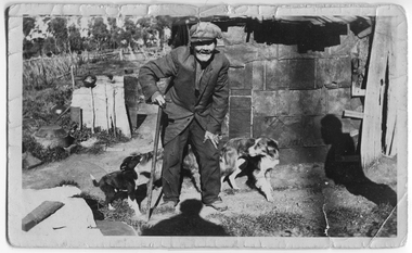 Tarnagulla History Archive
Photograph: Ah Youk, a Chinese resident of Tarnagulla, c. 1900-1920
Murray Comrie Collection. This photograph is an original print.A small monochrome photograph of a Chinese man with slightly bent posture, outside a slab hut, with a dog and a puppy beside him. Handwritten caption on reverse identifies subject as 'Ah Youk', a resident of Tarnagulla. Handwritten on reverse 'Tarnagulla's Last Chinaman Ah Youk' and 'E. Radnell Tarnagulla'. The latter probably indicates the person who took the photo and/or who gave it to Murray Comrie. Also printed on reverse 'Bock Print'.tarnagulla, people, chinese, radnell, bock print -
Bialik College
Article, 'Mr. Jona Impressed with Bialik Progress', The Australian Jewish Herald, 15 April 1965, 1965
Newspaper clipping, 'Mr. Jona Impressed with Bialik Progress', published in The Australian Jewish Herald, 15 April 1965. 'The progress made by Bialik College and the standard which at present has been attained, is certainly a credit to the headmaster Mr. Chowers, and to all those who have guided the College during its period of growth and development. This was said by Mr. Walter Jona, M.L.A, when he paid an official visit to the college on the invitation of the headmaster, Mr. Abraham Chowers. As one who is particularly interested in the Jewish Day School Movement, Mr. Jona took the opportunity to fully acquaint himself with the contribution being made to the movement by Bialik College which is the only Jewish Day School within his electorate. Mr. Jona toured all the classrooms and was particularly interested in the preparations being made for the Pesach Seder. In Grade 1 he was shown a Haggadah specially prepared for the children's use during the Seder complete with verse and illustrations. On leaving the college Mr. Jona commented, 'At Bialik the obvious enjoyment displayed by the children in their activities derived from both the teaching and environmental influence was most apparent.''shakespeare grove, 1960s -
 Greensborough Historical Society
Business card, Briar Hill Glass Centre, 2010_
Business card of Lino di Paola, Briar Hill Glass Centre, 15 Sherbourne Road Briar Hill 3088. Business closed c. 2011.Business card, black print on white card. briar hill glass centre, lino di paola -
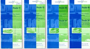 Melbourne Tram Museum
Ephemera - Timetable, Yarra Trams, Set of 15 Yarra Trams timetables, 7/1999 to 9/2001
Set of 15 Yarra Trams timetables, blue green cover with route number on cover, giving details of popular destination, check points, use of Metcards and contact details, tram hire, frequency, Some include maps. .1 - Route 11 - West Preston - City - July 1999 - 24 Pages .2 - Route 12 - South Melbourne and St Kilda Beach - City - July 1999 - 24 pages .3 - Route 48 and Route 34 - North Balwyn - City or via Latrobe St - East Melbourne, includes references to Routes 23, 24, 27 and 30 - July 1999 - 28 pages, includes a small map. .4 - ditto - August 2000 .5 - ditto - September 2001 .6 - Route 70 - Wattle Park - City - October 1999 - 24 pages .7 - Route 70 - Wattle Park - City via MCG - December 2000 - 24 pages - includes a map .8 - Route 75 - East Burwood - City - July 1999 - - 24 pages .9 - ditto - August 2000 .10 - Route 86 - Bundoora RMIT - Colonial Stadium via Bourke St - March 2000 - 28 page. .11 - Route 96 - St Kilda Beach - East Brunswick -March 2000 - 24 pages .12 - Route 109 - Mont Albert - Port Melbourne - July 1999 - includes references to route 23, 24, 27. 30 and 34 - 36 pages .13 - Route 109 - ditto includes La Trobe St services - September 2001 - 36 pages .14 - Route 112 - South Melbourne - St Kilda Beach to West Preston via City, including temporary combination of routes 11 and 12, route 11 and Route 12 - August 2000 - 48 pages. .15 - Route 112 - notes that it the combination of Routes 11 and 12 - September 2001 - 48 pages. .16 - Route 11 - West Preston - City - Nov. 1998 - 24 pages .17 - Route 48 - North Balwyn - City - Dec. 1998 - 24 pages .18 - Route 34 and 48 - North Balwyn - City and City LaTrobe - East Melbourne - August 2000 - 32 pages .19 - Route 109 - Port Melbourne - Mont Albert - Nov. 1998 - 24 pages.Some have notes such as "OPR", and number notes and notes written inside about changes or errors in ink. See History.trams, tramways, yarra trams, tram services, timetables, route 11, route 48, route 34, route 23, route 24, route 27, route 30, route 70, route 75, route 86, route 96, route 109, route 112 -
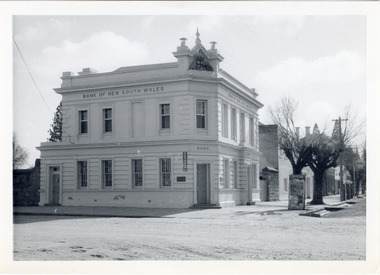 The Beechworth Burke Museum
Photograph
The old Bank of New South Wales building is located on the corner of Camp and Ford streets in Beechworth, Victoria. It was constructed between 1856 and 1857 from local honey coloured granite. It was designed by architects Robertson & Hale and is a two-storey rendered brick building and the original coat of arms is still visible. The coat of arms is distinctive and consists of a kangaroo, emu, lion, and rising sun. The rear of the building was surrounded by high granite walls for security as it was the original home for the local gold office. Beechworth Honey currently offers tourist accommodation in the Hive Apartment located in the former Bank of New South Wales Managers residence.The Bank of New South Wales building in Beechworth is significant for its location in one of Australia's most prominent goldfield towns. Of particular interest is the use of distinctive local Beechworth honey coloured granite in its construction. The building’s architecture is a simple, conservative classical style known as Renaissance Revival. It is one of the few known surviving works of the architects Robertson and Hale. The decorative composition above the main entrance and the counter in the banking chamber are of special interest.Black and white rectangular photograph printed on cardAHold bank of new south wales, bank of new south wales building, beechworth bank of new south wales, bank of nsw, beechworth 1850s, robertson and hale, architects robertson and hale, rendered brick, coat of arms, granite walls, local honey coloured granite, gold office, 1856, 1857, beechworth, beechworth honey, hive apartment, manager's residence, renaissance revival -
Glen Eira Historical Society
Pamphlet - ARTHUR STREET, 15, CAULFIELD NORTH
2 items relating to 15 Arthur Street: 1/Newspaper article from Property Review Weekly, on forthcoming sale of property, includes photograph. 2/Gary Peer flyer, includes 4 photographs of home and house plan for forthcoming auction.caulfield north, arthur street, edwardian style, brick, lead lights, jeffries emma mrs., toohey jno w., white alick, hart m.g. mrs., green godwin a., mitton g. m., brown t. mrs., samuel lear, samuel aviv -
Glen Eira Historical Society
Document - Hartington
A two page photocopy of a Caulfield Conservation Study by Andrew Ward, dated 10/1994, on the house Hartington at 15 Gladstone Parade. The study gives a description of the architectural features of the house, a brief history of the house and includes a photograph (100mm x 153mm) of the exterior of the house.kooyong park estate, hartington, burnett templeton captain, kirkham charles f, gladstone parade, clarence street, victorian style, hartington street, justices of the peace, ward andrew, land subdivisions, architectural styles, architectural features, windows, elsternwick, caulfield conservation study -
 Eltham District Historical Society Inc
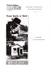
Folder, Commercial Bank of Australia Eltham Branch Hold-Up, 15 December 1949
Thursday, December 15, 1949, the quiet little bank was embroiled in an infamous wild shoot-out between a daring thief and two bank officers. Today, the building still carries the scars ; a bullet hole remains visible in a cedar bench testifying to the events that played out that day. 3.30 a.m., Friday, December 9. The manager of the Commercial Bank branch at Greensborough, Mr Harry Wallace and his wife are asleep in their bedroom of the little house behind the branch. Harry is awakened by a noise and sees an intruder in a corner of the bedroom. He calls out but the intruder who has switched off the power in anticipation flees through a side door and scarpers down Main Street. Harry summons the police but a search by First Constable Thomas of the Greensborough Police assisted by a wireless patrol car is unsuccessful. A report is filed noting the theft of a .25 calibre pistol from the wardrobe. Thursday, December 15th. It is 1pm and the Commercial Bank has just opened. The branch is only open Mondays and Thursdays from 1-3pm. The morning started off a little cool with some scattered showers but it has fined up and the temperature is now around 61 degrees (16 C). A new grey Singer sports car with soft-top pulls up on the opposite side of the road and a young man, neatly dressed in a dark blue suit, wearing a grey hat and carrying a brief case exits the vehicle. He looks around then crosses the road and walks up the steps and through the door into the bank. There are three people inside; Mr. Jack Burgoyne whose grocery store is situated just 50 yards up the road, Mr. Lindsay A. Spears, the Eltham Agency Receiving Officer and by chance, Mr Harry Wallace, manager of the Greensborough branch. Jack Burgoyne takes note of the young stranger; thinking to himself he appears nervous. The man approaches the counter and introduces himself as John Henderson of Greensborough and explains that he wishes to open a new account. He places his hat and £3 on the counter. Mr Spears attends to the paperwork. He asks the young man to sign two forms, which he does but then he withdraws from the counter and starts walking towards the door. Suddenly he spins around pulling an automatic pistol from his right-hand pocket. He exclaims forcefully; “The game’s on! I’ll take the lot!” Spears appears to comply by pretending to open a drawer. The man shouts loudly, “Keep your hand away from that drawer.” Spears instead reaches for a pistol in his pocket and challenges the man, “Here it is. Come and get it!” At the same time, Harry Wallace pulls a pistol from his pocket as well. The bandit fires a shot but misses, the bullet striking the counter. Both Spears and Wallace open fire and Jack Burgoyne ducks for cover. As the bandit turns and runs for the door leaving his £3 behind, he fires another shot, which strikes the ceiling. Spears fires back, and thinks he may have hit him in the foot. The bandit flees the bank and heads for the grey Singer car, registration NO-106, parked opposite. Wallace and Spears pursue him to the door and open fire again, striking the car three times around the driver’s door. Spears lets off eight shots and Wallace, seven before his gun jams. The getaway car initially heads slowly down Main Road towards Bridge Street. About 100 yards down the road, Dave Adams, a PMG employee, who has heard the shots, throws a steel manhole step at the driver. It hits the roof of the car nine inches above the driver’s head and tears the hood. Another witness claims to have seen the door blow open and the driver raise his hand. The car gathers speed and swings left into Bridge Street racing along at about 60 miles an hour careering recklessly past council employee, Mr. Percy Williams, who is driving a dray along Smarts Road [believed to be Bridge Street]. At the end of the road the Singer fails to get round the sharp turn and crashes into an embankment skidding to a stop outside the home of Mr John Clifford. One side of the car is wrecked. Mr Clifford, an aircraft engineer hears the fast travelling car bump heavily into the road bank at about 1.25 p.m. Hearing the whine of an engine he goes outside to find the grey Singer parked at the side of the road. Jack George also lives at the corner and hears the car crash. “The bandit opened the car door, ran 50 yards, and suddenly turned back,” exclaims Jack. “He took something from the car. It might have been a gun.” In his haste, the bandit drops his grey felt hat, size 6 7/8, on the road and dashes up Sherbourne Road for about 200 yards then disappears into the scrub carrying a brief case and a bundle in which a sailor’s cap can be seen. About 3 p.m., Mr H.D. Pettie of Mountain View Road, Montmorency is looking through his field glasses and notices a young man walking through thick scrub on private property some distance from his house. The man is wearing a sailor’s cap and disappears along the railway track toward Montmorency. As the day progresses, ten police cars, one motor cycle, and about 40 police led by Det. Sgt. McMennemin of Malvern CIB are searching for him. They believe he is hiding in thick scrub along the bank of the creek about half-a-mile outside Eltham township. Wireless patrol cars, four mobile traffic cars and the CIB area cars from Malvern and Kew are taking part. Police check the thief’s car and discover it was stolen from Helen Baxter, of Doncaster Road, North Balwyn from outside Victoria Barracks. Harry Wallace informs the police that he believes he recognised the bandit as the man who took his pistol from his bedroom the previous Friday morning. As night falls, armed police are posted at strategic points in the Eltham-Greensborough district. Police in cars are watching the roads. Others are searching the bush and checking passengers on trains. Little do they realise the young man has already slipped out of the net. SEQUEL YOUTH OF 19 CHARGED WITH ATTEMPTED ARMED ROBBERY OF BANK AT ELTHAM Weekly Times, Wednesday 15 February 1950, page 6 Detectives who raided a house in Bell St., Coburg, Melbourne, charged a 19-year-old youth, of South Yarra, with attempted armed robbery at the Commercial Bank’s Eltham (Vic.) receiving depot on Dec. 15. Police say they recovered a loaded automatic pistol, diamond and signet rings worth more than £200, a complete set of house-breaking instruments, a sailor’s uniform, and chloroform gauze in the raid. The youth was charged that while armed with an offensive weapon, he attempted to rob Lindsay George Spears of a sum of money. He was further charged on six counts of breaking, entering and stealing. Police allege that the person who tried to hold up Mr Spears in the Commercial Bank receiving depot at Eltham on December 15. escaped in a stolen car, after Mr Spears and Mr Henry Wallace, manager of the bank’s Greensborough branch, had fired at him. After the car crashed, he escaped into thick scrub and is alleged to have changed into a sailor’s uniform. On December 9 an automatic pistol was stolen from Mr Wallace’s bedroom at the Greensborough bank. The chloroform pad recovered is alleged to have been stolen from the Dental Supply Company, Plenty Road, Preston. The rings are alleged to have been taken in a £513 burglary from the shop of James Paton. Sydney Road, Coburg. Det. Sgt. H. McMennemin conducted the investigations with Senior Dets. R. Newton and M Downie, Detectives l. Dent, R. Rayner, P. Pedersen and M. Handley and First Constable A. Thomas. The youth will appear at Eltham Court on February 22. Manager’s Gun Used in Holdup at Bank The Age, Thursday 23 February 1950, page 4 It was stated in Eltham court yesterday that a youth who robbed a bank manager of his pistol, later used it in an attempt to hold-up the bank. Kay Arthur Morgan, 19, draftsman, of Castle-street, South Yarra, was committed for trial on charges of breaking and entering, and stealing a pistol and attempted robbery while armed with an offensive weapon. He pleaded guilty. The manager of Eltham branch of the Commercial Bank of Australia Ltd., Henry Clifton Cabot Wallace, said he disturbed someone in the bedroom, in which he and his wife were sleeping, at 3 a.m. on December. 9, 1949. Later he found that his automatic- pistol was missing. On December 15 a youth, who said his name was John Henderson, entered the bank and opened a new account. As the youth was leaving the bank he turned round with a pistol in his hand and said: — “I want the lot.” Spear indicated a drawer under the counter; and said.— “Here it is. Come and get it.” The youth said:— “Keep your hand away from that drawer.” Witness said Spear then drew his pistol from his hip pocket. The youth fired at them, and Spear returned the fire. “I pulled my pistol and fired, too” said witness. The youth fired again, ran out to a car and drove off. Witness and Spear fired several shots at the car. The youth was the accused Morgan, sitting in court, witness said. Evidence was given that one bullet was found in the celling and the other in the bank. Morgan was allowed £100 bail on each charge. Morgan ended up serving three years for the failed armed robbery and became a notorious criminal. He had twin sons, Peter and Doug and even though only ten years old, Morgan would get his sons to act as lookouts whilst he committed burglaries. The lads became building contractors but when the industry suffered a downturn in 1977 and they were short on cash, they returned to the family business. Over the following 23 months they undertook 24 raids on country and outer-suburban TABs and banks. Whilst robbing one country bank for the third time, just like their father, it all went wrong ending up with a police officer shot. They were nick-named the “After-dark” bandits and are considered to be Australia’s last bushrangers. They were convicted and served 17 years in prison.5 x A4 photocopied pagesbank hold-up, cba bank, det sgt mcmennemin, eltham, h.d. pettie, harry wallace, jack burgoyne, kay arthur morgan, lindsay a. spears, main road -
 Eltham District Historical Society Inc
Photograph - Aerial Photograph, Landata, Eltham; Crown Allotment 15, Section 5, Parish of Nillumbik (Stokes Orchard Estate), Feb. 1979
Centred on present day Diosma Rd, Stokes Pl, Nyora Rd and Eucalyptus Rd Historic Aerial Imagery Source: Landata.vic.gov.au Aerial Photo Details: Project No :1716 Project : WESTERN PORT FORESHORES Run : 15 Frame : 91 Date : 02/1979 Film Type : B/W Camera : RC8 Flying Height : 5500 Scale : 10000 Film Number : 3286 GDA2020 : 37°42'47"S, 145°09'57"E MGA2020 : 338339, 5824447 (55) Melways : 22 C4 (ed. 42) A History of the Development of Crown Allotment 15, Section 5, Parish of Nillumbik – Stokes Orchard Crown Allotment 15, Section 5, Parish of Nillumbik (CA15) is a square allotment of 158 acres or approximately a quarter of a square mile. It lies just beyond the eastern end of Pitt Street, south of Nyora Road to the northern end of Eucalyptus Road and extends east from Eucalyptus Road to Reynolds Road. The topography of CA15 is generally steep, sloping up to a hill near the centre of the land, the ridgeline passing through the properties along the southern side of Diosma Road. Eucalyptus Road is a straight north-south road with its northern end at the north west corner of CA15. Until the end of the 1970s this road was an un-named Government Road and was largely not open to traffic. With residential development in the 1970s the road was constructed, and the council allocated the name obviously in recognition of the predominant species of the local bushland. CA15 was purchased from the Crown by George D’Arley Boursiquot, a prominent Melbourne printer, on 28th October 1852. On November 23, 1922, former Member for Gippsland and Melbourne Real Estate Agent, Hubert Patrick Keogh purchased the allotment then sold it March 13, 1925, to local farmer, Robert David Taylor, a former Shire of Eltham Councillor (1911-1920) and Shire President (1919). Taylor had extensive land holdings stretching west towards Bible Street and Main Road. The Taylor home was situated at the top of the hill in Bible Street at present day 82 Bible Street. At the time of Taylor’s purchase in 1925, CA15 was subdivided into 48 lots that could be described as small rural properties or large residential lots. A typical lot size was one hectare or 2.5 acres. The subdivision created two roads, Nyora Road, and Diosma Road, each following an irregular alignment between Eucalyptus and Reynolds Roads. However, the lots were not sold off separately nor were the roads constructed. The land effectively remained as one parcel for many further years. Robert David Taylor died November 30, 1934, and probate was granted to his son of the same name, Robert David Taylor of Bible Street, Salesman and William McLelland Vance Taylor of 73 Emmeline Street, Northcote, Clerk, with the transfer of the land into their names on July 8, 1935. Frank Stokes worked as a qualified accountant at Kennons leather factory in Burnley, while living at 1 Thomas Street, Mitcham. He suffered from migraines and wanted to return to working the land (he had previously worked on farms and orchards since coming to Australia from England in 1926, both in WA and Vic.). He first travelled to the district by train in July 1942 to find land with the intention to establish an orchard. By chance he met Arthur Bird of Bird Orchard (bounded by Pitt Street, Eucalyptus Road, and Wattle Grove) and they got talking over their common interest. Arthur put Frank up for the night and pointed out the land, 158 acres- part of the Taylor Estate- £900, Crown Allotment 15, Section 5, Parish of Nillumbik (CA15) somewhat diagonally opposite Bird Orchard. Stokes applied through the Riverina Agency to purchase the land who in turn applied for permission from Canberra to sell as there was a new government regulation introduced during the Second World War banning land sales except for immediate production. Stokes obtained a loan on his Mitcham house of £600 @ 5% and paid £450 deposit with quarterly payments of £15 spread over 5 years. Stokes was assisted and advised by Arthur Bird who farmed the neighbouring orchard. In early 1943 Stokes took possession and would catch the train out to Eltham on Fridays after work and began building a hut on the corner of Nyora Road and the Government Road (Eucalyptus Road) for shelter and to lock up tools. He established an orchard on the central western part of the land through the centre of which ran a natural waterway (part of the present-day linear park) and was able to pay a neighbour (Hawkins) to help with clearing and fencing 25 acres, and with a horse and single furrowed plough, planted approximately 2,500 fruit trees - cherries, peaches, plums, almonds, pears, apricots and lemons as well as a few apples and oranges; a massive task. Aerial photographs from the 1940s through to the 1990s clearly show the orchard with most of the larger CA15 site remaining as natural bushland. A huge problem was hares and rabbits eating all the new buds off the tiny trees. As well as laying poison he painted the trees with a mixture of cow manure and lime, often working by moonlight. Procurement of wire and wire netting was difficult because of the war but after much effort he obtained a permit from the Agricultural Department for supplies in March 1944. In February 1945 Stokes applied for a permit to build a “packing shed” as no house building was allowed. It was to be 33 feet x 21 feet and cost £312. It was constructed mostly from second-hand materials, which were hard to obtain, especially iron for roofing. Stokes finished work at Kennons on October 31, 1945, and in March 1946 he sold the family home at Mitcham for £1,230 plus £170 for furniture. On May 15, 1946, title to the CA15 property was issued to Frank Howard Alfred Stokes, Orchardist and Gladys Ethel Stokes, Married Woman, both of Pitt Street, Eltham. The family of five then moved into the very unfinished “packing shed” at Eltham, which was a struggle to weatherproof. Eventually rooms were divided off and lined with hessian bags and whitewashed. Their income was firewood (cut and sold), selling rockery stones and cut Sweet Bursaria. (It was discovered during the 1940s that Sweet Bursaria contained the sunscreen compound Aesculin. The RAAF utilised this compound from Sweet Bursaria during WW2 for pilots and gunners.) The orchard’s first fruit sale was a half-case of Le Vanq peaches in December 1947 for the price of 8 shillings. In 1956 plans for house were drawn and Glen Iris bricks purchased (1956 Olympic Rings variant). The building of the house commenced in 1957 - 12 feet of original packing shed was removed – and was completed in 1959. Water was connected from newly built pressure storage on the property at the end of 1959 and the electricity connection for the first time at 3pm on April 29, 1960. The house remains to present day (somewhat modified) at 1 Nyora Road, home to Nyora Studio Gallery. On occasions, spare remnants of the 1956 bricks have been known to be unearthed in gardens on the estate as they were utilised by Frank Stokes to fill in rabbit holes. On May 26, 1950, a parcel of land was compulsorily acquired by the Melbourne and Metropolitan Board of Works on the hilltop to establish an easement for a high-level service reservoir to augment Eltham’s water supply. The project also included pipe tracks for the necessary water mains. The reservoir has now been superseded by higher level water tanks east of Reynolds Road and its former site is now a public reserve. On November 27, 1964, the State Electricity Commission served notice to compulsorily acquire a further parcel through the eastern part of the land for a major electricity transmission line that augmented supply from the La Trobe Valley to Melbourne. The easement was registered February 11, 1966. The easement was widened July 18, 1969 for a second transmission line to be constructed. In 1971 Melbourne Metropolitan Planning Scheme amendments adopted Nyora Road as the boundary between a residential zone to the north and a rural zone to the south. This determined the future development of the land. In the mid-1970s the Shire of Eltham divided the orchard into numerous rate-able parcel lots, the 48 lots having been established in 1925 and the subsequent rates assessment proved unsustainable for Stokes. He commenced selling lots outside the boundary of the orchard, north of Diosma and South of Nyora. However shortly later the land between Nyora and Diosma Roads and west of the electricity easement was sold and subdivided into residential lots, a housing development by Macquarie Builders and marketed as the Stokes Orchard Estate. New streets were created, and most were named after trees, although one, Stokes Place, commemorates the former owners. The development was undertaken in two stages; Stage 1 (1975) encompassing Scarlet Ash Court, Ironbark Close and Peppermint Grove bounded by Nyora and Eucalyptus roads and Stage 2 (1978) encompassing Stokes Place, Orchard Way, The Crest and The Lookout bound by Nyora and Diosma roads. The developer, Macquarie Builders went bankrupt shortly after the release of Stage 2 leaving many purchasers to fend for themselves and arrange for their own independent builders. There were also difficulties with sewerage for the land immediately south of Diosma Road and so the conventional residential lots were abandoned in favour of larger lots. The development of Orchard Way, The Crest and The Lookout did not proceed as planned and the proposed lots were incorporated into five-acre parcels instead. These included a low-density group housing development by the Graves family and the award winning Choong House (1983) with Gordon Ford developed garden immediately next door situated on the ridge of the hill nestled amongst the original bush, Eucalypt trees and Sweet Bursaria. In 1994, Nillumbik Shire Council applied Significant Environment and Significant Landscape overlays upon the properties on the south side of Diosma Road to ensure protection of this natural bush garden environment. With the arrival of the sewer along Diosma Road in the 1990s, most of these five-acre parcels have since been subdivided multiple times. The Choong house presently sits on a 2.7-acre property, which in 2022 Nillumbik Council nominated for Cultural Significance Heritage protection and is considered potentially significant at State level. The Stokes family were also associated with the Eltham Christian Church. In the 1970s this church had met in temporary premises in Eltham. Lots of the original 1925 subdivision remained south of Nyora Road and a number of these lots were utilized for the Eltham Christian School, which was established by the Eltham Christian Church in 1981. The school operated on this site until 2000. The premises are now used by The Vine Baptist Church. By the mid-1980s the whole of CA15 had been developed for residential and school purposes, except for the sections north of Diosma Road and between the transmission lines and Reynolds Road. Sewerage issues had been resolved for the section north of Diosma Road and in 1987 it was in the process of being subdivided into residential lots. The development coincided with the discovery of colonies of the rare and endangered Eltham Copper Butterfly on the site. This resulted in a community and political campaign to save the butterfly habitat. With the co-operation of the land developer the subdivision was altered to create two bushland reserves in the critical butterfly habitat areas. In the late 1980s the State Government was investigating options for establishing a metropolitan ring road link between Diamond Creek and Ringwood. The chosen route was adjacent to Reynolds Road and so this created a freeze on development of CA15 between Reynolds Road and the electricity easement. The ring road proposal was eventually abandoned, and this part of the land was subdivided into low density residential lots. Diosma Road has been discontinued at the electricity easement and the eastern part incorporated into View Mount Court with access from Reynolds Road. The whole of CA15 has now been developed for residential or associated purposes, ranging from conventional density to quite low density south of Nyora Road. Some remnants of the orchard remain, a few cherry trees on the Graves property and a lone apple tree in Stokes Place. The butterfly reserves comprise significant areas of remnant bushland. Linear reserves through the estate link with central Eltham via the Woodridge linear reserve and with Research along the electricity easement. CA15 as it exists today has a complicated history of rural use, Government acquisition, urban development, and community action. References: • “Stokes Orchard, an incomplete history”; Russell Yeoman with Doug Orford • Correspondence, Beryl Bradbury (nee Stokes) • Aerial Photographs, 1931-1991, Landata (landata.vic.gov.au) • Certificate of Title, Vol. 4930 Fol. 985900 • Plan Number LP 10859 aerial photo, diosma road, eltham copper butterfly, eucalyptus road, ironbark close, nyora road, peppermint grove, peter & elizabeth pidgeon collection, power transmission lines, reynolds road, scarlet ash court, stokes orchard estate, stokes place, woodridge estate, frank stokes -
 Eltham District Historical Society Inc
Photograph - Aerial Photograph, Landata, Eltham; Crown Allotment 15, Section 5, Parish of Nillumbik (Stokes Orchard Estate), Jan. 1984
Centred on present day Diosma Rd, Stokes Pl, Nyora Rd and Eucalyptus Rd Historic Aerial Imagery Source: Landata.vic.gov.au Aerial Photo Details: Project No :1716 Project : WESTERN PORT FORESHORES Run : 15 Frame : 70 Date : 01/1984 Film Type : B/W Camera : RC8 Flying Height : 5300 Scale : 10000 Film Number : 3833 GDA2020 : 37°42'38"S, 145°10'09"E MGA2020 : 338612, 5824719 (55) Melways : 22 D4 (ed. 42) A History of the Development of Crown Allotment 15, Section 5, Parish of Nillumbik – Stokes Orchard Crown Allotment 15, Section 5, Parish of Nillumbik (CA15) is a square allotment of 158 acres or approximately a quarter of a square mile. It lies just beyond the eastern end of Pitt Street, south of Nyora Road to the northern end of Eucalyptus Road and extends east from Eucalyptus Road to Reynolds Road. The topography of CA15 is generally steep, sloping up to a hill near the centre of the land, the ridgeline passing through the properties along the southern side of Diosma Road. Eucalyptus Road is a straight north-south road with its northern end at the north west corner of CA15. Until the end of the 1970s this road was an un-named Government Road and was largely not open to traffic. With residential development in the 1970s the road was constructed, and the council allocated the name obviously in recognition of the predominant species of the local bushland. CA15 was purchased from the Crown by George D’Arley Boursiquot, a prominent Melbourne printer, on 28th October 1852. On November 23, 1922, former Member for Gippsland and Melbourne Real Estate Agent, Hubert Patrick Keogh purchased the allotment then sold it March 13, 1925, to local farmer, Robert David Taylor, a former Shire of Eltham Councillor (1911-1920) and Shire President (1919). Taylor had extensive land holdings stretching west towards Bible Street and Main Road. The Taylor home was situated at the top of the hill in Bible Street at present day 82 Bible Street. At the time of Taylor’s purchase in 1925, CA15 was subdivided into 48 lots that could be described as small rural properties or large residential lots. A typical lot size was one hectare or 2.5 acres. The subdivision created two roads, Nyora Road, and Diosma Road, each following an irregular alignment between Eucalyptus and Reynolds Roads. However, the lots were not sold off separately nor were the roads constructed. The land effectively remained as one parcel for many further years. Robert David Taylor died November 30, 1934, and probate was granted to his son of the same name, Robert David Taylor of Bible Street, Salesman and William McLelland Vance Taylor of 73 Emmeline Street, Northcote, Clerk, with the transfer of the land into their names on July 8, 1935. Frank Stokes worked as a qualified accountant at Kennons leather factory in Burnley, while living at 1 Thomas Street, Mitcham. He suffered from migraines and wanted to return to working the land (he had previously worked on farms and orchards since coming to Australia from England in 1926, both in WA and Vic.). He first travelled to the district by train in July 1942 to find land with the intention to establish an orchard. By chance he met Arthur Bird of Bird Orchard (bounded by Pitt Street, Eucalyptus Road, and Wattle Grove) and they got talking over their common interest. Arthur put Frank up for the night and pointed out the land, 158 acres- part of the Taylor Estate- £900, Crown Allotment 15, Section 5, Parish of Nillumbik (CA15) somewhat diagonally opposite Bird Orchard. Stokes applied through the Riverina Agency to purchase the land who in turn applied for permission from Canberra to sell as there was a new government regulation introduced during the Second World War banning land sales except for immediate production. Stokes obtained a loan on his Mitcham house of £600 @ 5% and paid £450 deposit with quarterly payments of £15 spread over 5 years. Stokes was assisted and advised by Arthur Bird who farmed the neighbouring orchard. In early 1943 Stokes took possession and would catch the train out to Eltham on Fridays after work and began building a hut on the corner of Nyora Road and the Government Road (Eucalyptus Road) for shelter and to lock up tools. He established an orchard on the central western part of the land through the centre of which ran a natural waterway (part of the present-day linear park) and was able to pay a neighbour (Hawkins) to help with clearing and fencing 25 acres, and with a horse and single furrowed plough, planted approximately 2,500 fruit trees - cherries, peaches, plums, almonds, pears, apricots and lemons as well as a few apples and oranges; a massive task. Aerial photographs from the 1940s through to the 1990s clearly show the orchard with most of the larger CA15 site remaining as natural bushland. A huge problem was hares and rabbits eating all the new buds off the tiny trees. As well as laying poison he painted the trees with a mixture of cow manure and lime, often working by moonlight. Procurement of wire and wire netting was difficult because of the war but after much effort he obtained a permit from the Agricultural Department for supplies in March 1944. In February 1945 Stokes applied for a permit to build a “packing shed” as no house building was allowed. It was to be 33 feet x 21 feet and cost £312. It was constructed mostly from second-hand materials, which were hard to obtain, especially iron for roofing. Stokes finished work at Kennons on October 31, 1945, and in March 1946 he sold the family home at Mitcham for £1,230 plus £170 for furniture. On May 15, 1946, title to the CA15 property was issued to Frank Howard Alfred Stokes, Orchardist and Gladys Ethel Stokes, Married Woman, both of Pitt Street, Eltham. The family of five then moved into the very unfinished “packing shed” at Eltham, which was a struggle to weatherproof. Eventually rooms were divided off and lined with hessian bags and whitewashed. Their income was firewood (cut and sold), selling rockery stones and cut Sweet Bursaria. (It was discovered during the 1940s that Sweet Bursaria contained the sunscreen compound Aesculin. The RAAF utilised this compound from Sweet Bursaria during WW2 for pilots and gunners.) The orchard’s first fruit sale was a half-case of Le Vanq peaches in December 1947 for the price of 8 shillings. In 1956 plans for house were drawn and Glen Iris bricks purchased (1956 Olympic Rings variant). The building of the house commenced in 1957 - 12 feet of original packing shed was removed – and was completed in 1959. Water was connected from newly built pressure storage on the property at the end of 1959 and the electricity connection for the first time at 3pm on April 29, 1960. The house remains to present day (somewhat modified) at 1 Nyora Road, home to Nyora Studio Gallery. On occasions, spare remnants of the 1956 bricks have been known to be unearthed in gardens on the estate as they were utilised by Frank Stokes to fill in rabbit holes. On May 26, 1950, a parcel of land was compulsorily acquired by the Melbourne and Metropolitan Board of Works on the hilltop to establish an easement for a high-level service reservoir to augment Eltham’s water supply. The project also included pipe tracks for the necessary water mains. The reservoir has now been superseded by higher level water tanks east of Reynolds Road and its former site is now a public reserve. On November 27, 1964, the State Electricity Commission served notice to compulsorily acquire a further parcel through the eastern part of the land for a major electricity transmission line that augmented supply from the La Trobe Valley to Melbourne. The easement was registered February 11, 1966. The easement was widened July 18, 1969 for a second transmission line to be constructed. In 1971 Melbourne Metropolitan Planning Scheme amendments adopted Nyora Road as the boundary between a residential zone to the north and a rural zone to the south. This determined the future development of the land. In the mid-1970s the Shire of Eltham divided the orchard into numerous rate-able parcel lots, the 48 lots having been established in 1925 and the subsequent rates assessment proved unsustainable for Stokes. He commenced selling lots outside the boundary of the orchard, north of Diosma and South of Nyora. However shortly later the land between Nyora and Diosma Roads and west of the electricity easement was sold and subdivided into residential lots, a housing development by Macquarie Builders and marketed as the Stokes Orchard Estate. New streets were created, and most were named after trees, although one, Stokes Place, commemorates the former owners. The development was undertaken in two stages; Stage 1 (1975) encompassing Scarlet Ash Court, Ironbark Close and Peppermint Grove bounded by Nyora and Eucalyptus roads and Stage 2 (1978) encompassing Stokes Place, Orchard Way, The Crest and The Lookout bound by Nyora and Diosma roads. The developer, Macquarie Builders went bankrupt shortly after the release of Stage 2 leaving many purchasers to fend for themselves and arrange for their own independent builders. There were also difficulties with sewerage for the land immediately south of Diosma Road and so the conventional residential lots were abandoned in favour of larger lots. The development of Orchard Way, The Crest and The Lookout did not proceed as planned and the proposed lots were incorporated into five-acre parcels instead. These included a low-density group housing development by the Graves family and the award winning Choong House (1983) with Gordon Ford developed garden immediately next door situated on the ridge of the hill nestled amongst the original bush, Eucalypt trees and Sweet Bursaria. In 1994, Nillumbik Shire Council applied Significant Environment and Significant Landscape overlays upon the properties on the south side of Diosma Road to ensure protection of this natural bush garden environment. With the arrival of the sewer along Diosma Road in the 1990s, most of these five-acre parcels have since been subdivided multiple times. The Choong house presently sits on a 2.7-acre property, which in 2022 Nillumbik Council nominated for Cultural Significance Heritage protection and is considered potentially significant at State level. The Stokes family were also associated with the Eltham Christian Church. In the 1970s this church had met in temporary premises in Eltham. Lots of the original 1925 subdivision remained south of Nyora Road and a number of these lots were utilized for the Eltham Christian School, which was established by the Eltham Christian Church in 1981. The school operated on this site until 2000. The premises are now used by The Vine Baptist Church. By the mid-1980s the whole of CA15 had been developed for residential and school purposes, except for the sections north of Diosma Road and between the transmission lines and Reynolds Road. Sewerage issues had been resolved for the section north of Diosma Road and in 1987 it was in the process of being subdivided into residential lots. The development coincided with the discovery of colonies of the rare and endangered Eltham Copper Butterfly on the site. This resulted in a community and political campaign to save the butterfly habitat. With the co-operation of the land developer the subdivision was altered to create two bushland reserves in the critical butterfly habitat areas. In the late 1980s the State Government was investigating options for establishing a metropolitan ring road link between Diamond Creek and Ringwood. The chosen route was adjacent to Reynolds Road and so this created a freeze on development of CA15 between Reynolds Road and the electricity easement. The ring road proposal was eventually abandoned, and this part of the land was subdivided into low density residential lots. Diosma Road has been discontinued at the electricity easement and the eastern part incorporated into View Mount Court with access from Reynolds Road. The whole of CA15 has now been developed for residential or associated purposes, ranging from conventional density to quite low density south of Nyora Road. Some remnants of the orchard remain, a few cherry trees on the Graves property and a lone apple tree in Stokes Place. The butterfly reserves comprise significant areas of remnant bushland. Linear reserves through the estate link with central Eltham via the Woodridge linear reserve and with Research along the electricity easement. CA15 as it exists today has a complicated history of rural use, Government acquisition, urban development, and community action. References: • “Stokes Orchard, an incomplete history”; Russell Yeoman with Doug Orford • Correspondence, Beryl Bradbury (nee Stokes) • Aerial Photographs, 1931-1991, Landata (landata.vic.gov.au) • Certificate of Title, Vol. 4930 Fol. 985900 • Plan Number LP 10859 aerial photo, diosma road, eltham copper butterfly, eucalyptus road, ironbark close, nyora road, peppermint grove, peter & elizabeth pidgeon collection, power transmission lines, reynolds road, scarlet ash court, stokes orchard estate, stokes place, woodridge estate, frank stokes -
 Eltham District Historical Society Inc
Photograph - Aerial Photograph, Landata, Eltham; Crown Allotment 15, Section 5, Parish of Nillumbik (Stokes Orchard Estate), Mar. 1987
Centred on present day Diosma Rd, Stokes Pl, Nyora Rd and Eucalyptus Rd Historic Aerial Imagery Source: Landata.vic.gov.au Aerial Photo Details: Project No :1716 Project : WESTERN PORT FORESHORES Run : 15 Frame : 108 Date : 03/1987 Film Type : B/W Camera : RC10 Flying Height : 5600 Scale : 10000 Film Number : 4102 GDA2020 : 37°43'00"S, 145°10'13"E MGA2020 : 338725, 5824036 (55) Melways : 22 D5 (ed. 42)719 (55) Melways : 22 D4 (ed. 42) A History of the Development of Crown Allotment 15, Section 5, Parish of Nillumbik – Stokes Orchard Crown Allotment 15, Section 5, Parish of Nillumbik (CA15) is a square allotment of 158 acres or approximately a quarter of a square mile. It lies just beyond the eastern end of Pitt Street, south of Nyora Road to the northern end of Eucalyptus Road and extends east from Eucalyptus Road to Reynolds Road. The topography of CA15 is generally steep, sloping up to a hill near the centre of the land, the ridgeline passing through the properties along the southern side of Diosma Road. Eucalyptus Road is a straight north-south road with its northern end at the north west corner of CA15. Until the end of the 1970s this road was an un-named Government Road and was largely not open to traffic. With residential development in the 1970s the road was constructed, and the council allocated the name obviously in recognition of the predominant species of the local bushland. CA15 was purchased from the Crown by George D’Arley Boursiquot, a prominent Melbourne printer, on 28th October 1852. On November 23, 1922, former Member for Gippsland and Melbourne Real Estate Agent, Hubert Patrick Keogh purchased the allotment then sold it March 13, 1925, to local farmer, Robert David Taylor, a former Shire of Eltham Councillor (1911-1920) and Shire President (1919). Taylor had extensive land holdings stretching west towards Bible Street and Main Road. The Taylor home was situated at the top of the hill in Bible Street at present day 82 Bible Street. At the time of Taylor’s purchase in 1925, CA15 was subdivided into 48 lots that could be described as small rural properties or large residential lots. A typical lot size was one hectare or 2.5 acres. The subdivision created two roads, Nyora Road, and Diosma Road, each following an irregular alignment between Eucalyptus and Reynolds Roads. However, the lots were not sold off separately nor were the roads constructed. The land effectively remained as one parcel for many further years. Robert David Taylor died November 30, 1934, and probate was granted to his son of the same name, Robert David Taylor of Bible Street, Salesman and William McLelland Vance Taylor of 73 Emmeline Street, Northcote, Clerk, with the transfer of the land into their names on July 8, 1935. Frank Stokes worked as a qualified accountant at Kennons leather factory in Burnley, while living at 1 Thomas Street, Mitcham. He suffered from migraines and wanted to return to working the land (he had previously worked on farms and orchards since coming to Australia from England in 1926, both in WA and Vic.). He first travelled to the district by train in July 1942 to find land with the intention to establish an orchard. By chance he met Arthur Bird of Bird Orchard (bounded by Pitt Street, Eucalyptus Road, and Wattle Grove) and they got talking over their common interest. Arthur put Frank up for the night and pointed out the land, 158 acres- part of the Taylor Estate- £900, Crown Allotment 15, Section 5, Parish of Nillumbik (CA15) somewhat diagonally opposite Bird Orchard. Stokes applied through the Riverina Agency to purchase the land who in turn applied for permission from Canberra to sell as there was a new government regulation introduced during the Second World War banning land sales except for immediate production. Stokes obtained a loan on his Mitcham house of £600 @ 5% and paid £450 deposit with quarterly payments of £15 spread over 5 years. Stokes was assisted and advised by Arthur Bird who farmed the neighbouring orchard. In early 1943 Stokes took possession and would catch the train out to Eltham on Fridays after work and began building a hut on the corner of Nyora Road and the Government Road (Eucalyptus Road) for shelter and to lock up tools. He established an orchard on the central western part of the land through the centre of which ran a natural waterway (part of the present-day linear park) and was able to pay a neighbour (Hawkins) to help with clearing and fencing 25 acres, and with a horse and single furrowed plough, planted approximately 2,500 fruit trees - cherries, peaches, plums, almonds, pears, apricots and lemons as well as a few apples and oranges; a massive task. Aerial photographs from the 1940s through to the 1990s clearly show the orchard with most of the larger CA15 site remaining as natural bushland. A huge problem was hares and rabbits eating all the new buds off the tiny trees. As well as laying poison he painted the trees with a mixture of cow manure and lime, often working by moonlight. Procurement of wire and wire netting was difficult because of the war but after much effort he obtained a permit from the Agricultural Department for supplies in March 1944. In February 1945 Stokes applied for a permit to build a “packing shed” as no house building was allowed. It was to be 33 feet x 21 feet and cost £312. It was constructed mostly from second-hand materials, which were hard to obtain, especially iron for roofing. Stokes finished work at Kennons on October 31, 1945, and in March 1946 he sold the family home at Mitcham for £1,230 plus £170 for furniture. On May 15, 1946, title to the CA15 property was issued to Frank Howard Alfred Stokes, Orchardist and Gladys Ethel Stokes, Married Woman, both of Pitt Street, Eltham. The family of five then moved into the very unfinished “packing shed” at Eltham, which was a struggle to weatherproof. Eventually rooms were divided off and lined with hessian bags and whitewashed. Their income was firewood (cut and sold), selling rockery stones and cut Sweet Bursaria. (It was discovered during the 1940s that Sweet Bursaria contained the sunscreen compound Aesculin. The RAAF utilised this compound from Sweet Bursaria during WW2 for pilots and gunners.) The orchard’s first fruit sale was a half-case of Le Vanq peaches in December 1947 for the price of 8 shillings. In 1956 plans for house were drawn and Glen Iris bricks purchased (1956 Olympic Rings variant). The building of the house commenced in 1957 - 12 feet of original packing shed was removed – and was completed in 1959. Water was connected from newly built pressure storage on the property at the end of 1959 and the electricity connection for the first time at 3pm on April 29, 1960. The house remains to present day (somewhat modified) at 1 Nyora Road, home to Nyora Studio Gallery. On occasions, spare remnants of the 1956 bricks have been known to be unearthed in gardens on the estate as they were utilised by Frank Stokes to fill in rabbit holes. On May 26, 1950, a parcel of land was compulsorily acquired by the Melbourne and Metropolitan Board of Works on the hilltop to establish an easement for a high-level service reservoir to augment Eltham’s water supply. The project also included pipe tracks for the necessary water mains. The reservoir has now been superseded by higher level water tanks east of Reynolds Road and its former site is now a public reserve. On November 27, 1964, the State Electricity Commission served notice to compulsorily acquire a further parcel through the eastern part of the land for a major electricity transmission line that augmented supply from the La Trobe Valley to Melbourne. The easement was registered February 11, 1966. The easement was widened July 18, 1969 for a second transmission line to be constructed. In 1971 Melbourne Metropolitan Planning Scheme amendments adopted Nyora Road as the boundary between a residential zone to the north and a rural zone to the south. This determined the future development of the land. In the mid-1970s the Shire of Eltham divided the orchard into numerous rate-able parcel lots, the 48 lots having been established in 1925 and the subsequent rates assessment proved unsustainable for Stokes. He commenced selling lots outside the boundary of the orchard, north of Diosma and South of Nyora. However shortly later the land between Nyora and Diosma Roads and west of the electricity easement was sold and subdivided into residential lots, a housing development by Macquarie Builders and marketed as the Stokes Orchard Estate. New streets were created, and most were named after trees, although one, Stokes Place, commemorates the former owners. The development was undertaken in two stages; Stage 1 (1975) encompassing Scarlet Ash Court, Ironbark Close and Peppermint Grove bounded by Nyora and Eucalyptus roads and Stage 2 (1978) encompassing Stokes Place, Orchard Way, The Crest and The Lookout bound by Nyora and Diosma roads. The developer, Macquarie Builders went bankrupt shortly after the release of Stage 2 leaving many purchasers to fend for themselves and arrange for their own independent builders. There were also difficulties with sewerage for the land immediately south of Diosma Road and so the conventional residential lots were abandoned in favour of larger lots. The development of Orchard Way, The Crest and The Lookout did not proceed as planned and the proposed lots were incorporated into five-acre parcels instead. These included a low-density group housing development by the Graves family and the award winning Choong House (1983) with Gordon Ford developed garden immediately next door situated on the ridge of the hill nestled amongst the original bush, Eucalypt trees and Sweet Bursaria. In 1994, Nillumbik Shire Council applied Significant Environment and Significant Landscape overlays upon the properties on the south side of Diosma Road to ensure protection of this natural bush garden environment. With the arrival of the sewer along Diosma Road in the 1990s, most of these five-acre parcels have since been subdivided multiple times. The Choong house presently sits on a 2.7-acre property, which in 2022 Nillumbik Council nominated for Cultural Significance Heritage protection and is considered potentially significant at State level. The Stokes family were also associated with the Eltham Christian Church. In the 1970s this church had met in temporary premises in Eltham. Lots of the original 1925 subdivision remained south of Nyora Road and a number of these lots were utilized for the Eltham Christian School, which was established by the Eltham Christian Church in 1981. The school operated on this site until 2000. The premises are now used by The Vine Baptist Church. By the mid-1980s the whole of CA15 had been developed for residential and school purposes, except for the sections north of Diosma Road and between the transmission lines and Reynolds Road. Sewerage issues had been resolved for the section north of Diosma Road and in 1987 it was in the process of being subdivided into residential lots. The development coincided with the discovery of colonies of the rare and endangered Eltham Copper Butterfly on the site. This resulted in a community and political campaign to save the butterfly habitat. With the co-operation of the land developer the subdivision was altered to create two bushland reserves in the critical butterfly habitat areas. In the late 1980s the State Government was investigating options for establishing a metropolitan ring road link between Diamond Creek and Ringwood. The chosen route was adjacent to Reynolds Road and so this created a freeze on development of CA15 between Reynolds Road and the electricity easement. The ring road proposal was eventually abandoned, and this part of the land was subdivided into low density residential lots. Diosma Road has been discontinued at the electricity easement and the eastern part incorporated into View Mount Court with access from Reynolds Road. The whole of CA15 has now been developed for residential or associated purposes, ranging from conventional density to quite low density south of Nyora Road. Some remnants of the orchard remain, a few cherry trees on the Graves property and a lone apple tree in Stokes Place. The butterfly reserves comprise significant areas of remnant bushland. Linear reserves through the estate link with central Eltham via the Woodridge linear reserve and with Research along the electricity easement. CA15 as it exists today has a complicated history of rural use, Government acquisition, urban development, and community action. References: • “Stokes Orchard, an incomplete history”; Russell Yeoman with Doug Orford • Correspondence, Beryl Bradbury (nee Stokes) • Aerial Photographs, 1931-1991, Landata (landata.vic.gov.au) • Certificate of Title, Vol. 4930 Fol. 985900 • Plan Number LP 10859 aerial photo, diosma road, eltham copper butterfly, eucalyptus road, ironbark close, nyora road, peppermint grove, peter & elizabeth pidgeon collection, power transmission lines, reynolds road, scarlet ash court, stokes orchard estate, stokes place, woodridge estate, frank stokes