Showing 676 items
matching australian sketcher
-
 Robin Boyd Foundation
Slide, Robin Boyd
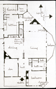
Colour slide in a mount. Image of the sketch plan of the Desbrowe Annear House (in Robin Boyd's handwriting), 36-38 The Eyrie, Eaglemont, Victoria, Australia (1903)Made in Australia / Encircled 37 (Handwritten) / Encircled A (Handwritten)slide, robin boyd -
 Robin Boyd Foundation
Slide, Robin Boyd
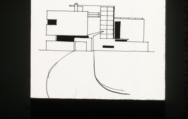
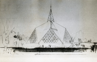
Colour slide in a mount. Sketch elevation by Robin Boyd of Pollard House, Surrey, England, 1932. (Architects: Amyas Connell of Connell, Ward & Lucas.)Made in Australia / Encircled 1 (Handwritten)the puzzle of architecture, slide -
 Robin Boyd Foundation
Slide, Robin Boyd
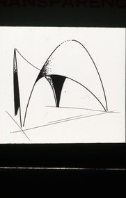
Colour slide in a mount. Sketch elevation of Candela's shell for church of San Antonio de Las Huertas, Mexico 1959. (Architect: Felix Candela.)Made in Australia / Encircled 32 (Handwritten)the puzzle of architecture, slide -
 Robin Boyd Foundation
Document - Manuscript, Robin Boyd, ("Once a year....")
This piece was written just after the Melbourne Film Festival, where no Australian feature film was shown. It mourns the lack of support for the Australian film industry - Canada has been able to do it, why can't we use this as a model?Typewritten (c copy), pencil edits, 2nd copy typewritten (c copy), quarto, 3 pages225c. in pencil on the side. On back of last page, blue biro sketch - a fireplace?film industry, canadian film industry, australian film industry, john grierson, robin boyd, manuscript -
 Robin Boyd Foundation
Document - Manuscript, Robin Boyd, (have you ever tried to define the character of our city?)
An attempt to define Melbourne's character. Boyd sketches a history of Melbourne's architectural periods. He muses on the importance of public taste as necessary for periods of architectural flourish. He thinks Australia is in a "trough between the waves of progress."Typewritten, foolscap, 5 pagesmelbourne, urban conservation, robin boyd, manuscript -
 Robin Boyd Foundation
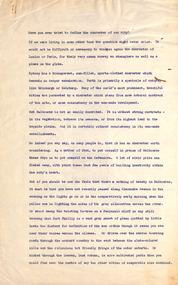
Painting, Donald Laycock, Sketch for Terra Australis, 1969
This oil sketch by Donald Laycock is for "Terra Australis", a large (20' X 8') outback desert scene commissioned by Robin Boyd for the Australian Pavilion at Expo 1970. Robin Boyd was the Exhibit Architect of the Australian Pavilions at Expo '70 in Osaka and Expo '67 in Montreal. It is not known what happened to "Terra Australis" after Expo '70.Red toned abstract composition."DL 69" in bottom right corner. Sketch for Terra Australis Exhibition '70" written on canvas around the frame on the rear.donald laycock, expo 70, osaka, robin boyd, walsh st artwork, ohm2022, ohm2022_32 -
 Victorian Aboriginal Corporation for Languages
Periodical, Australian Institute of Aboriginal and Torres Strait Islander Studies, Australian Aboriginal studies : journal of the Australian Institute of Aboriginal and Torres Strait Islander Studies, 2010
Mediating conflict in the age of Native Title Peter Sutton (The University of Adelaide and South Australian Museum) Mediators have played roles in managing conflict in Aboriginal societies for a long time. This paper discusses some of the similarities and differences between older customary mediator roles and those of the modern Native Title process. Determinants of tribunal outcomes for Indigenous footballers Neil Brewer, Carla Welsh and Jenny Williams (School of Psychology, Flinders University) This paper reports on a study that examined whether football tribunal members? judgments concerning players? alleged misdemeanours on the sporting field are likely to be shaped by extra-evidential factors that disadvantage players from Indigenous backgrounds. Indigenous and non-Indigenous Australian Football League (AFL) players, matched in terms of their typical levels of confidence and demeanour in public situations, were interrogated in a mock tribunal hearing about a hypothetical incident on the football field. The specific aim was to determine if the pressures of such questioning elicited behavioural differences likely to be interpreted as indicative of testimonial unreliability. Mock tribunal members (number = 103) then made judgments about the degree to which a number of behavioural characteristics were evident in the players? testimonies. Under intense interrogation, Indigenous players were judged as presenting less confidently and displaying a greater degree of gaze aversion than non-Indigenous players. These behavioural characteristics are commonly ? and inappropriately ? used as cues or heuristics to infer testimonial accuracy. The paper discusses the implications for Indigenous players appearing at tribunal hearings ? and for the justice system more broadly. Timothy Korkanoon: A child artist at the Merri Creek Baptist Aboriginal School, Melbourne, Victoria, 1846?47 ? a new interpretation of his life and work Ian D Clark (School of Business, University of Ballarat) This paper is concerned with the Coranderrk Aboriginal artist Timothy Korkanoon. Research has uncovered more about his life before he settled at the Coranderrk station in 1863. Evidence is provided that five sketches acquired by George Augustus Robinson, the former Chief Protector of Aborigines, in November 1851 in Melbourne, and found in his papers in the State Library of New South Wales, may also be attributed to the work of the young Korkanoon when he was a student at the Merri Creek Baptist Aboriginal School from 1846 to 1847. Developing a database for Australian Indigenous kinship terminology: The AustKin project Laurent Dousset (CREDO, and CNRS, Ecole des Hautes Etudes en Sciences Sociales), Rachel Hendery (The Australian National University), Claire Bowern (Yale University), Harold Koch (The Australian National University) and Patrick McConvell (The Australian National University) In order to make Australian Indigenous kinship vocabulary from hundreds of sources comparable, searchable and accessible for research and community purposes, we have developed a database that collates these resources. The creation of such a database brings with it technical, theoretical and practical challenges, some of which also apply to other research projects that collect and compare large amounts of Australian language data, and some of which apply to any database project in the humanities or social sciences. Our project has sought to overcome these challenges by adopting a modular, object-oriented, incremental programming approach, by keeping metadata, data and analysis sharply distinguished, and through ongoing consultation between programmers, linguists and communities. In this paper we report on the challenges and solutions we have come across and the lessons that can be drawn from our experience for other social science database projects, particularly in Australia. A time for change? Indigenous heritage values and management practice in the Coorong and Lower Murray Lakes region, South Australia Lynley A Wallis (Aboriginal Environments Research Centre, The University of Queensland) and Alice C Gorman (Department of Archaeology, Flinders University) The Coorong and Lower Murray Lakes in South Australia have long been recognised under the Ramsar Convention for their natural heritage values. Less well known is the fact that this area also has high social and cultural values, encompassing the traditional lands and waters (ruwe) of the Ngarrindjeri Nation. This unique ecosystem is currently teetering on the verge of collapse, a situation arguably brought about by prolonged drought after decades of unsustainable management practices. While at the federal level there have been moves to better integrate typically disparate ?cultural? and ?natural? heritage management regimes ? thereby supporting Indigenous groups in their attempts to gain a greater voice in how their traditional country is managed ? the distance has not yet been bridged in the Coorong. Here, current management planning continues to emphasise natural heritage values, with limited practical integration of cultural values or Ngarrindjeri viewpoints. As the future of the Coorong and Lower Murray Lakes is being debated, we suggest decision makers would do well to look to the Ngarrindjeri for guidance on the integration of natural and cultural values in management regimes as a vital step towards securing the long-term ecological viability of this iconic part of Australia. Hearts and minds: Evolving understandings of chronic cardiovascular disease in Aboriginal and Torres Strait Islander populations Ernest Hunter (Queensland Health and James Cook University) Using the experience and reflections of a non-Indigenous clinician and researcher, Randolph Spargo, who has worked in remote Aboriginal Australia for more than 40 years, this paper tracks how those at the clinical coal-face thought and responded as cardiovascular and other chronic diseases emerged as new health concerns in the 1970s to become major contributors to the burden of excess ill health across Indigenous Australia. The paper cites research evidence that informed prevailing paradigms drawing primarily on work in which the clinician participated, which was undertaken in the remote Kimberley region in the north of Western Australia. Two reports, one relating to the Narcoonie quarry in the Strzelecki Desert and the other concerning problematic alcohol use in urban settings.maps, b&w photographs, colour photographs, tablesstrzelecki desert, native title, timothy korkanoon, merri creek baptist aboriginal school, austkin project, coorong, lower murray lakes district, south australia, indigenous health -
 Victorian Aboriginal Corporation for Languages
Book, Mrs James Smith, The Booandik tribe of South Australian Aborigines : a sketch of their habits, customs, legends, and language : also an account of the efforts made by Mr. and Mrs. James Smith to Christianise and civilise them, 1880
... Australian Aborigines : a sketch of their habits, customs, legends ...Stories from the early days of South Australia from an adventurous woman, recounting her experiences with the local Aboriginal community. Much detail of early encounters with domestic animals and mission folk.Word lists, b&w illustrationsbooandik, boandik, buandig -
Victorian Aboriginal Corporation for Languages
Book, Robert Brough Smyth, The Aborigines of Victoria : with notes relating to the habits of the natives of other parts of Australia and Tasmania : compiled from various sources for the Government of Victoria by R. Brough Smyth : vol. 1, 1878
Produced in two large volumes, Robert Brough Smyth has collected information on various tribes and their customs, as well as their physical and mental character; birth and education of children; marriage; death and burial of the dead; daily lives of the natives; food; diseases; dress and personal ornaments; weapons; implements and manufacturers; nets and fish hooks; methods of producing fire; canoes and myths. Smyth also devotes about two hundred pages to Aboriginal languages, as well as including details and customs of the aborigines in Tasmania. Complete with hundreds of sketches, the work is still a valuable resource not only for those with in an interest in aboriginal culture, but also those wanting to know the early history of Australia.maps, b&w illustrations, word listsrobert brough smyth, anthropology, aboriginal social life and customs, children, behaviour, death and burial customs, daily life, food, diseases, weapons, shields, boomerang, vessels, baskets, message sticks, stone tool technology, fire, canoes, myths, stories -
Victorian Aboriginal Corporation for Languages
Book, Robert Brough Smyth, The Aborigines of Victoria : with notes relating to the habits of the natives of other parts of Australia and Tasmania : compiled from various sources for the Government of Victoria by R. Brough Smyth : vol. 2, 1878
Produced in two large volumes, Robert Brough Smyth has collected information on various tribes and their customs, as well as their physical and mental character; birth and education of children; marriage; death and burial of the dead; daily lives of the natives; food; diseases; dress and personal ornaments; weapons; implements and manufacturers; nets and fish hooks; methods of producing fire; canoes and myths. Smyth also devotes about two hundred pages to Aboriginal languages, as well as including details and customs of the aborigines in Tasmania. Complete with hundreds of sketches, the work is still a valuable resource not only for those with in an interest in aboriginal culture, but also those wanting to know the early history of Australia.b&w illustrations, word listsrobert brough smyth, philip chauncy, william ridley, albert le souef, a. w. howitt, john moore davis, william locke, a. f. a. greeves, language comparisons, phrenology, aboriginal social life and customs, death and burial customs, weapons, tasmania, lake tyers, lake wellington, gippsland, ballarat, brabrolong, lake hindmarsh, kotoopna -
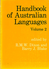
 Victorian Aboriginal Corporation for Languages
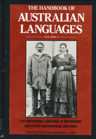
Book, R M W Dixon, The handbook of Australian languages : volume 4, the Aboriginal language of Melbourne and other grammatical sketches, 1991
maps, word lists, b&w illustrations, b&w photographs -
 Victorian Aboriginal Corporation for Languages
Book, Robert M Dixon, Handbook of Australian Languages. Vol.2, Wargamay, the Mpakwithi dialect of Anguthimri, Watjarri, Margany and Gunya Tasmanian, 1981
Various authors, includes technical linguistic sketch grammars of Wargamay, Mpakwithi (Anguthimri), Watjarri, Margany, Gunya and a survey of extant Tasmanian materials.Maps, word listswargamay, mpakwithi dialect of anguthimri, watjarri, margany, gunya tasmanian -
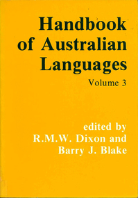 Victorian Aboriginal Corporation for Languages
Book, Robert M Dixon, Handbook of Australian Languages. Vol. 3, Djapu, a Yolngu dialect, Yukulta, Uradhi & Nyawaygi, 1983
Various authors, includes technical linguistic sketch grammars of Djapu (Yolngu), Yukulta, Uradhi, and Nyawaygi.Maps, diagrams, word listsdjapu, yolngu, yukulta, uradhi, nyawaygi -
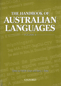 Victorian Aboriginal Corporation for Languages
Book, Robert M Dixon, The handbook of Australian languages. Vol.5, Grammatical sketches of Bunuba, Ndje?bbana and Kugu Nganhcara, 2000
Maps, word listsbunuba, ndjebbana, kugu nganhcara, south kimberley region, western australia, central arnhem land, cape york peninsula, north queensland, language programs, bilingual education, language in media -
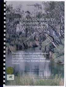 Victorian Aboriginal Corporation for Languages
Book, Julie Reid, Wergaia community grammar and dictionary, 2007
This consultation draft is a sketch grammar of Wergaia, incorporating a revised Wergaia Wordlist (version 1), now renamed Wergaia dictionary, which was developed from recent and historical sources, and funded by the Victorian Aboriginal Corporation for Languages. It is not intended for use as a language course. To fully understand its contents, the reader will need a high level of knowledge about the structure of Australian languages. Rather, it is intended for use as an adjunct to a course in Wergaia, such as the VCE Study Design Indigenous Languages of Victoria: Revival and Reclamation - Wergaia.colour photographs, b&w photographs, word listswergaia, wotjobaluk, barengi gadyin land council inc, grammar, language learning -
 Robin Boyd Foundation
Slide, Robin Boyd
Colour slide in a mount. Sketch for the Chapel for Divinity School, Richmond, California, USAMade in Australia / Encircled 3 (Handwritten) / Chapel for Divinity / School / Richmond California/ Hunter ----- (Handwritten)slide, robin boyd -
 Robin Boyd Foundation
Slide, Robin Boyd
Colour slide in a mount. Sketch elevations by Robin Boyd. Central one of Eero Saarinen's TWA terminal New York airport, 1962 . (Architect: Eero Saarinen.)Made in Australia / Encircled 1 (Handwritten)the puzzle of architecture, slide -
 Hume City Civic Collection
Container - Bottle, wine, 1985
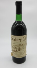
The bottle was donated to the Council by Hedley Elliott for an exhibition in the Art Gallery (George Evans Museum). Note that Goonawarra is misspelt on the label.Green glass bottle used for 1975 claret and bottled for the first Sunbury Fair. The label is printed in brown and cream and features a sketch of the Goonawarra Winery and surrounding area. There is a brief statement on the back about the winery and the background to production of the wine. On the back is a hand-written label, stuck on with clear tape giving an account of the origin of the bottle of wine, its donor and storage instructions. It has a black metal cap and miscellaneous markings on the flat bottom."Sunbury Fair / Goonawarra Vineyard (above) was established / in Sunbury in 1858 by the / Hon. J. G. Francis, former Premier of Victoria. / This 1975 Claret from the Stanley Wine Co. / was bottled by Emerald Wines especially / for the Sunbury Fair / WINE PRODUCED IN AUSTRALIA F100 750ml". The hand-written label is signed by John McKerrow in 1985.sunbury fair, wines, goonawarra vineyard, stanley wine company, emerald wines, elliott, hedley, mckerrow, john, festivals and celebrations, francis, j.g. (hon.), george evans collection, 1970s -
 Wangaratta Art Gallery
Painting, Norma Bull, Lifting Waves, c. 1960s
Norma Bull is an Australian painter who is most famous for her paintings and sketches made during World War II in Britain as an official war artist. Bull was a finalist in the Archibald prize twice, in 1952 and 1953. Her work is featured in collections around the world including the Royal Collection, the Imperial War Museum, the National Gallery of Australia, and the Bright Art Gallery.traditionalRural City of Wangaratta Collection. Donated by Associate Professor Leslie E Bolitho AM.A windy seascape painted in oil using blues, browns, greens, yellows, and whites.Obverse: Norma Bull/ (bottom left)wangaratta art gallery, norma bull, seascape, painting -
 Nillumbik Shire Council
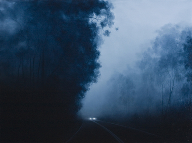
Painting: Camilla TADICH, Camilla Tadich, 6.23am Kangaroo Ground, 2009
Tadich spends time observing night time phenomena, the light from the moon, street lights and other sources; atmospheric states, fog and dampness and the nature of surfaces, vegetation, road, vehicles and buildings. She uses photographs and sketches before settling on the final idea for a work.This painting is typical of Tadich's recent work. She continues her exploration of the Australian landscape (most often the local, Nillumbik Shire). It is 'a dramatic interplay between narrative, landscape and the binaries of light/dark and the known/unknown of local landscape. The swathes of darkness within the work(s) pose questions about our inscribed fears and tensions, both cultural and existential'. (catalogue, 'Silent Space' Ex. 2006) Tadich's early experiences of fireworks, simple fireworks and bonfire in the surrounding bush of her outer Melbourne home, caught her imagination. She was inspired to investigate the issues surrounding nights in the bush. In this painting the narrative is ambiguous, the pinpricks of light, in this case from the car headlights provide a critical element. We can distinguish familiar features, a road, trees and a car that suggest human presence. However, what is going on is unclear. The resulting tension can leave us unsure, unsettled and anxious.Oil on canvascamilla tadich, nillumbik shire council, kangaroo ground -
 National Wool Museum
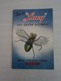
Booklet, This is Lucy the Green blowfly Who Strikes Your Sheep, 1970
Part of a collection of items donated by Mrs Robyn Adams. Mrs Adams' is the daughter of Victor Clyde, a wool grower who owned and used the items in the donated collection.Paper booklet, 28 pages. Front cover is blue and white with black and red text and a colour sketch of a blue and green fly. Title reads - This is / "Lucy" / THE GREEN BLOWFLY / WHO STRIKES YOUR / SHEEP-. Internal pages have short text with images describing the effects of fly strike on sheep and ways to prevent it. Back cover is blank with small text in the centre reading -Printers: / COLOURSTONE PTY. LTD. / SYDNEY.-fly strike, mrs robyn adams, australian wool board -
 National Wool Museum
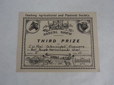
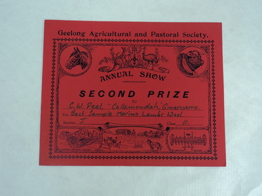
Certificate
Certificate awarded to Mr. Charles Wilson Peel for the best sample of merino lambs wool at the annual show for the Geelong Agricultural and Pastoral Society. The certificate is undated. Mr Peel owned a superfine merino stud at Gnawarre named Callenondah.Cream coloured stiff paper certificate with black printed text and sketches. Black ink handwritten personalised text to C.W. Peel for best lambs wool sample. Heading at top of certificate above the Australian coat of arms and sketch of horse and cow heads. -
 National Wool Museum
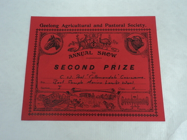
Certificate
Certificate awarded to Mr. Charles Wilson Peel for the best sample of merino lambs wool at the annual show for the Geelong Agricultural and Pastoral Society. The certificate is undated. Mr Peel owned a superfine merino stud at Gnawarre named Callenondah.Red coloured stiff paper certificate with black printed text and sketches. Black ink handwritten personalised text to C.W. Peel for best lambs wool sample. Heading at top of certificate above the Australian coat of arms and sketch of horse and cow heads. -
 National Wool Museum
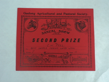
Certificate
Certificate awarded to Mr. Charles Wilson Peel for the best sample of merino lambs wool at the annual show for the Geelong Agricultural and Pastoral Society, 1973. The certificate is undated. Mr Peel owned a superfine merino stud at Gnawarre named Callenondah. Red coloured stiff paper certificate with black printed text and sketches. Black ink handwritten personalised text to C.W. Peel for best lambs wool sample. Heading at top of certificate above the Australian coat of arms and sketch of horse and cow heads. -
 National Wool Museum
Certificate
Certificate awarded to Mr. Charles Wilson Peel for the best sample of merino lambs wool at the annual show for the Geelong Agricultural and Pastoral Society. The certificate is undated. Mr Peel owned a superfine merino stud at Gnawarre named CallenondahRed coloured stiff paper certificate with black printed text and sketches. Black ink handwritten personalised text to C.W. Peel for best lambs wool sample. Heading at top of certificate above the Australian coat of arms and sketch of horse and cow heads. -
 National Wool Museum
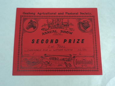
Document - Certificate, 1973
Certificate awarded to Mr. Charles Wilson Peel for the best sample of Corriedale ewe or wether fleece at the annual show for the Geelong Agricultural and Pastoral Society, 1973. The certificate is undated. Mr Peel owned a superfine merino stud at Gnawarre named Callenondah.Red coloured stiff paper certificate with black printed text and sketches. Black ink handwritten personalised text to C.W. Peel for best corriedale wool sample. Heading at top of certificate above the Australian coat of arms and sketch of horse and cow heads.geelong agricultural and pastoral society, corriedal ewe, wether fleece, charles wilson peel -
 National Wool Museum
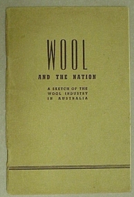
Book, Wool and the Nation- a sketch of the Wool Industry in Australia
"Wool and the Nation: a sketch of the Wool Industry in Australia" - Goldsborough Mort and Company Limited, 1946."Wool and the Nation: a sketch of the Wool Industry in Australia" - Goldsborough Mort and Company Limited, 1946.wool - history wool growing wool brokering wool industry wool processing wool sales, goldsbrough, mort and company limited, wool - history, wool growing, wool brokering, wool industry, wool processing, wool sales -
 Latrobe Regional Gallery
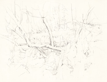
Drawing, TONKIN, Mary. Born 1973, Melbourne, Australia, Fork, Kalorama, 2010
Pencil on paperSignature and date on back of work. Tertiary inscription: '205888'sketch, drawing, landscape, trees -
Koorie Heritage Trust
Book, Bonwick, James, A Sketch of Boroondara, 1968
boroondara-history -
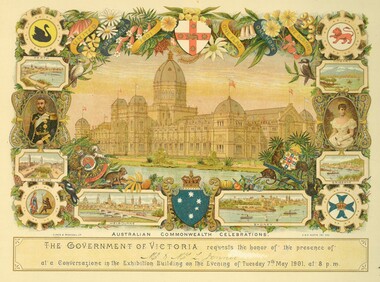 National Trust of Australia (Victoria)
Invitation
All the invitations are for the celebrations in Melbourne connected with the opening of the Parliament of the Commonwealth of Australia, on the 9th of May 1901. The Duke and Duchess of Cornwall and York were to be present.An invitation to Mr and Mrs Jenner to attend a Conversazione in the Exhibition Buildings, on 7th May 1901 at 8pm. Card depicts a sketch of the Exhibition Buildings. Surrounding the sketch are the coats of arms for the six states, sketches of the Capital cities, Australian flora and fauna and portraits of the Duke and Duchess of Cornwall and York. The coats of arms of the Commonwealth and Australia."AUSTRALIAN COMMONWEALTH CELEBRATIONS" "THE GOVERNMENT OF VICTORIA requests the honor of the presence of Mr & Mrs L Jenner at a Conversazione in the Exhibition Building on the Evening of Tuesday 7th May 1901 at 8 p.m.rippon lea