Showing 8323 items
matching bridging
-
 Stawell Historical Society Inc
Archive - Books & Papers, Ken Hyslop, Campbells Bridge Back to 1991, 1991
Associated with Back to Campbells Bridge and writing of Campbells bridge development and Social History 1861 - 1991. By Ken HyslopRecords relating to Campbells Bridge back to 1991. Plus Back to sign in bookVisitors Booksocial history -
 Kew Historical Society Inc
Photograph - Zig-Zag Bridge, 1924
Henry Beater Christian (1886-1962) , was a descendant of one of the earliest settler families in Kew. Employed at the Kew Asylum as a 'public servant', he was a skilled amateur photographer, photographing numerous scenes in Kew and on his travels around Victoria. The majority of his photographs date from 1916 to 1929. His finest photographs are housed in two photograph albums. Digital copy of a photograph from page 8 of the 47-page photograph album containing 261 gelatinous silver images, loaned by Diane Washfold with permission given to digitise and hold a copy in our collection. This photograph reveals how the photographer, Henry Christian, positioned himself to take the photograph from the angle in which he was interested. A skilled canoeist, an empty canoe is on the left bank that he apparently he used to access his vantage point. His subject, the Zig-Zag Bridge linked the grounds of the Yarra Bend and Kew Asylums. The wooden bridge was constructed in the 1870s and lasted through numerous floods until its destruction in 1929. A horizontal structure, the walkway was reached via a wooden staircase on the Studley Park end. The steps were requires due to the different levels of the banks on this stretch of the river. "Zig-Zag Bridge"henry beater christian (1886-1962), landscape photography, kew (vic.) — yarra river, christian-washfold collection, photograph albums, zig-zag bridge -
 Kew Historical Society Inc
Photograph - Zig-Zag Bridge, 1924
Henry Beater Christian (1886-1962) , was a descendant of one of the earliest settler families in Kew. Employed at the Kew Asylum as a 'public servant', he was a skilled amateur photographer, photographing numerous scenes in Kew and on his travels around Victoria. The majority of his photographs date from 1916 to 1929. His finest photographs are housed in two photograph albums. Digital copy of a photograph from page 8 of the 47-page photograph album containing 261 gelatinous silver images, loaned by Diane Washfold with permission given to digitise and hold a copy in our collection. This photograph reveals how the photographer, Henry Christian, positioned himself to take the photograph from the angle in which he was interested. A skilled canoeist, an empty canoe is on the left bank that he apparently he used to access his vantage point. His subject, the Zig-Zag Bridge linked the grounds of the Yarra Bend and Kew Asylums. The wooden bridge was constructed in the 1870s and lasted through numerous floods until its destruction in 1929. A horizontal structure, the walkway was reached via a wooden staircase on the Studley Park side. The steps were requires due to the different levels of the banks on this stretch of the river. "Zig-Zag Bridge"henry beater christian (1886-1962), landscape photography, kew (vic.) — yarra river, christian-washfold collection, photograph albums, zig-zag bridge -
 Phillip Island and District Historical Society Inc.
Photograph, ?
One of a collection of photographs purchased from Photo First, Thompson Avenue, Cowes, when it closed in June, 2014. The bridge was built in 1939 and opened in November 1940. Large Black & White photograph of Phillip Island Suspension Bridge, the first bridge from San Remo to Newhaven.phillip island suspention bridge, suspension bridge, photo first phillip island -
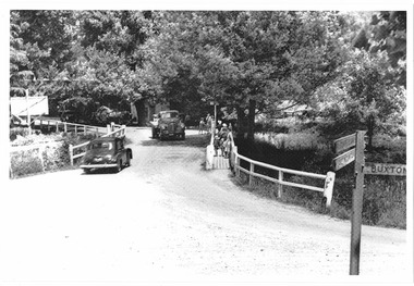
 Halls Gap & Grampians Historical Society
Photograph - Coloured
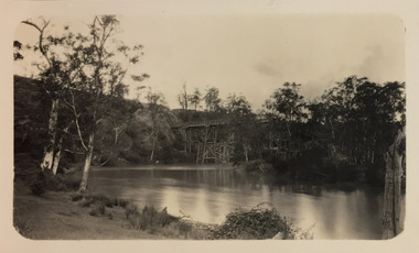
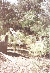
An old bridge at Back Creek on the Heatherlie Quarry Rail line.Photo shows the beginning of a bridge that has become dilapidated with time. Large beams lie around covered in weeds. Bushy growth has grown over the bridge.structures, bridges -
 Rutherglen Historical Society
Image, c1928
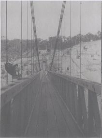
Photocopies of Hume Weir photographs 1928-29One of three black and white photographs, photocopied onto a single sheet of A4 paper. This one is of a walkway on a suspension bridge.Written on paper next to photo: "Along the 600' suspension bridge 300' above creek"hume weir, suspension bridge, bridges -
Glenelg Shire Council Cultural Collection
Photograph - Photograph - Portland scene, c. 1970
Photographic print of a rephotographed photograph. Image shows lower north slope Observatory Hill, fence along base, then wooden bridge over Salt Creek that drains into bay, near the Spit Portland.Front: 'Bridge over Portland drain' - green ink -
 Orbost & District Historical Society
photograph, first half of 20th century prior to 1976
Purchased from Orbost Op shop several years ago. Original owner unknown. This bridge over the Snowy River was opened on July 4 1922. It was constructed in 1922 alongside the previous suspension bridge. Its building was a combined effort of the Victorian Railways and the Country Roads Board at a cost of 35,000 pounds. It was replaced in 1976 by the present bridge after several major floods.This bridge was replaced in 1976 after several major floods.A wooden framed photograph of the second Snowy River bridge at Orbost.photograph snowy-river-bridge -
 Sunshine and District Historical Society Incorporated
Photographs (1928), 'QUARTER MILE' BRIDGE Construction, 1928
One man lost his life during the building of this bridge. The bridge was constructed by the Victorian Railways between 1927 to 1929 to carry a new double track goods line. This enabled trains from all parts of the state except Gippsland to have direct access to the Tottenham marshalling and sorting yards. These yards were constructed in the 1920's to relieve congestion in the Melbourne Yard near Spencer Street station. The congestion was being caused by the construction of suburban passenger platforms associated with the electrification of the suburban railway network. Initially the bridge was for goods trains but during the Second World War it was also used by troop trains. When the standard gauge line was built in 1962 all trains to Albury and Sydney have used this route, thus avoiding travelling through Essendon and Pascoe Vale on the suburban tracks. The standard gauge track across the bridge took the place of one of the broad gauge tracks so broad gauge trains crossing the bridge in either direction have to now use the same track. The bridge is 1,257 feet (383.13 metres) long and 180 feet (54.86 metres) above the water level. It is just 63 feet (19.2 metres) short of a quarter mile in length between abutments. There is a similar bridge on the same railway line crossing the Moonee Ponds Creek between Gowenbrae and Glenroy, however it is smaller at 1060 feet (323.08 metres) length and 115 feet (35.05) height.The bridge is now Victorian Heritage Registered under Number: H1197, and Heritage Overlay Numbers HO5, and HO107. On the Heritage Register it is named RAIL BRIDGE (ALBION VIADUCT). According to the Heritage Report the bridge is scientifically and architecturally important because of its large size, and because of the cost effective design features such as two girders per span (one for each track), the K bracing in the towers, and the broad flange beams as columns. When it was being built it was the largest trestle bridge in Australia, and until the Sydney Harbour bridge was constructed it was the highest railway bridge.Five B&W yellowing photos showing stages of construction of the Maribyrnong River Viaduct known as the Trestle Bridge but mainly known locally as the QUARTER MILE BRIDGE. It is a railway only bridge which runs over the Maribyrnong River between Sunshine North and Keilor East. A sixth image, which is not part of this set of photos, is included to show what the completed bridge looks like. -
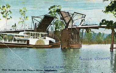 Lakes Entrance Historical Society
Photograph - Bridges, V S M Series, 1920 c
Hand tinted postcard showing Paddle Steamer 'Tanjil' passing upstream under the open Swan Reach Bridge on the Tambo River, East Gippsland, Victoria.New Bridge over the Tambo River Swan Reach Paddle Steamerships and shipping, waterways, bridges -
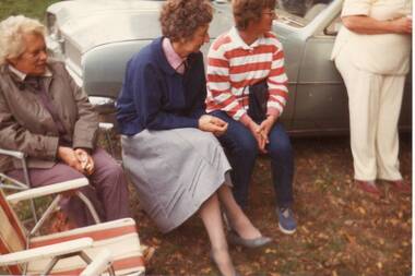 Clunes Museum
Photograph
BRIDGE OPENING 14TH APRIL 1986BRENDA TREMBATH, BETH COLLINS, LYN DUNNE AT BRIDGE OPENING.local history, photography, photographs, bridges -
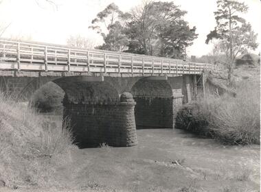 Hume City Civic Collection
Photograph, Early 1970s
The Macedon Street Bridge over Jacksons Creek is important because it was built on one of Victoria's first important roads. It replaced a smaller lighter bridge in 1857 and continued to be used until the early 1970s.A black and white photograph of a two arched bluestone bridge over a creek. A wooden post and rail fence painted white has been constructed in front of the original stone wall of the bridge.bridges, bluestone bridges, jacksons creek, macedon street, george evans collection -
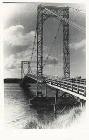 Phillip Island and District Historical Society Inc.
Photograph, Suspension Bridge, 1950's
First Suspension Bridge built 1940 between Newhaven & San Remo. Bridge opened by Hon. Albert Dunstan, Premier of Victoria. Photograph taken from San RemoBlack & White photograph of Suspension Bridge between Newhaven & San Remolocal history, photographs, film civil engineering, bridge, black & white photograph, jack jenner, phillip island bridge -
 Sunbury Family History and Heritage Society Inc.
Photograph
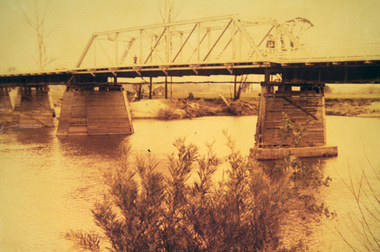
The photograph was taken when some work was being carried out on one of the arched railway bridges on the Sunbury line. The bridge spans the Jackson Creek and across the Rupertswood viaduct. The bridge over the Rupertswood Viaduct is one of the five significant bridges which span the railway line between Diggers Rest and Clarkfield.A black and white photograph of a bridge with scaffolding erected around the base of the arches.bridges, rupertswood viaduct, railway bridges -
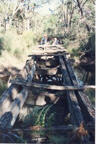
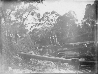
 Halls Gap & Grampians Historical Society
Photograph - B/W, C 1880
This photo shows the first Delley's Bridge, built to cross the Fyans Creek to provide access to Halls Gap and beyond in the 1880's. The bridge was swept away a number of times in floods. This bridge was replaced by a higher timber structure but constant erosion of the creek bank eventually led to its replacement by a timber and concrete structure. After nearly 50 years of its use, wear and tear necessitated a fourth bridge to be erected in 2001.A log bridge across a creek with a man standing on the bridge. A woman in a white dress and hat is beside the creek and a man is standing near her on the bank. In the left background a house can just be seen through the trees.structures, bridges -
 Lakes Entrance Historical Society
Postcard - North Arm bridge Lakes Entrance Victoria, 1917c
Also sepia toned photographic print 10cmx15cm, good condition old cat No 310 or 318? (Club Hotel and Hummocks area cropped from top) also Black and white photographic print 12.5cmx18cm, good condition- 2 copies 'Original T-Beam bridge opened Sept 1917 on reverse P01151-3.Black and white photographic miniature postcard showing the concrete bridge over the North Arm, showing the extended abutments, and shortened bridge length compared to previous bridge, causing restriction of waterway. Two walkers and horse drawn vehicle, buggy, on bridge. Remaining piles of wooden bridge upstream of bridge, telegraph poles upstream of bridge and across mudflats. Bridge to Bullock Island from mudflat, Club Hotel, Cunninghame Arm, and sand hummocks in distance. Lakes Entrance Victoriabridges, waterways, coast, transport, hotels -
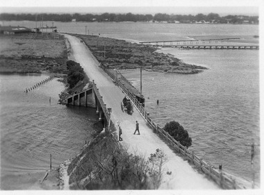
Phillip Island and District Historical Society Inc.
Photograph
Phillip Island Suspension Bridge - 1st road connection between Phillip Island and the mainland at San Remo 1938. Part of an album compiled and donated by Mrs Helen Jansson.Phillip Island Suspension Bridge.Descriptive caption adjoining this photo print, also the previous one.local history, photography, photographs, slides, film, civil engineering, bridges, phillip island bridge, black & white photograph, mrs. helen jansson, suspension bridges, phillip island -
 Halls Gap & Grampians Historical Society
Photograph - Coloured
An old bridge on the Heatherlie Quarry rail line at Back Creek, this line was used to transport sandstone from the quarry to Stawell.Photo shows an old bridge with 3 adults at the end, one male standing and 2 adults sitting. The bridge consists of large wooden beams,cross beams and supports .water can be seen at the bottom of the depression. Bush surrounds the bridge.structures, bridges -
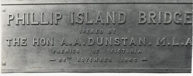 Phillip Island and District Historical Society Inc.
Photograph, 29/11/1940
One of a collection of over 400 photographs in an album commenced in 1960 and presented to the Phillip Island & Westernport Historical Society by the Shire of Phillip IslandPhotograph of the Bronze Plaque on the first Phillip Island Bridge showing wording clearly. 29/11/1940Phillip Island Bridge opened by The Hon A. A. Dunstan M. L. A. Premier of Victoria 29th November 1940.local history, photography, photographs, bronze plaque on first phillip island bridge, black & white photograph, phillip island bridge, the hon. a. a. dunstan. mla, john jenner, bryant west -
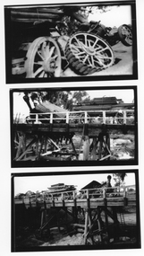 Stawell Historical Society Inc
Photograph, Traction Engine Accident on the Joel Joel bridge -- 3 Photos
Joel Joel Bridge Traction Engine Accident. Set of three photographs. C1922 Wimmera Bridge on Stawell Road. For information on accident see third SheetThree B/W photos of an accident on a bridge. A Traction engine broke through the surface of the bridge whilst towing a trailer full of lumber. the top photo is a close up of the tractor ashowing the rear wheel still on the bridge. The Second Photo shows the tractor and trailer from left rear, while the last phot shows the Secen from the right front.shire, archie slorach, joel area, john frampton -
 Stawell Historical Society Inc
Photograph, Bridge Building -- Possibly Delley's Bridge c1901
Photo of 3 women with a dog standing on a bridge with 5 men possible working on the Bridge in the Grampians. Photo taken in the area where Delley’s Bridge now stands, Hall’s Gap. c1901Sepia Post Card depiction people around a log bridge over a waterway in bush setting.Post Cardstawell -
Glenelg Shire Council Cultural Collection
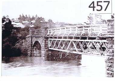
Postcard - Postcard - Suspension bridge Casterton, 1900-1930
SOURCED FROM CASTERTON TOWN HALL (FORMER SHIRE OF GLENELG) Sourced from Casterton Town Hall (Former Shire of Glenelg)Postcard, black and white,, showing the suspension bridge at Casterton, view across river towards townshipFront: 'SUSPN BRIDGE CASTERTON' Back: Handwritten correspondence, addressed to 'Miss M. Sythaleigh, Henty St Casterton' -
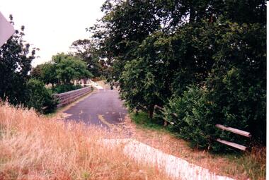 Hume City Civic Collection
Photograph, c 1980s
The stone bridge was the only entry into Sunbury on the eastern side of the town and was in use until the road was re-routed and widened in the 1970s.A coloured photograph of the roadway over the Macedon Street bridge which spans Jacksons Creek. There is a grassy area in the foreground with trees growing either side of the bridge. The narrow asphalted surface of the road across the bridge is cut off by a low stone wall.stone bridges, jacksons creek, macedon street road bridge, george evans collection -
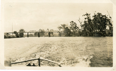 Lakes Entrance Historical Society
Photograph - Bridges, 1925
Photo taken same year Swan Reach bridge collapsed 16 November 1925Black and white photograph of the lifting bridge over the Tambo River taken from the stern of a boat. A tourist launch under the bridge in distance. Swan Reach Victoriabridges, waterways -
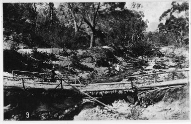
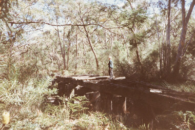 Halls Gap & Grampians Historical Society
Photograph - Coloured, C 1980s
This is a photo of one of the trestle bridges on the Heatherlie Quarry train line. It is located near the current site of "the Pines" campground. The woman on the bridge is Janet Witham.Photo is of a derelict trestle bridge over a shallow creek, taken on an angle. There are many sleepers missing and the bridge is surrounded by thick bush and trees. There is bracken in the left foreground. A woman wearing a blue top and grey/brown slacks.structures, bridges, quarrying, heatherlie -
 Greensborough Historical Society
Photograph, Plenty River Greensborough, 1910c
It shows the Plenty river in Greensborough in flood and the bluestone bridge at the bottom of the Main Street hill.The bluestone bridge was built in the mid 1860's and was demolished 1970's.A black and white photograph of a bridge over a river in flood.Nilgreensborough, plenty river, floods, bridges, bluestone -
 Orbost & District Historical Society
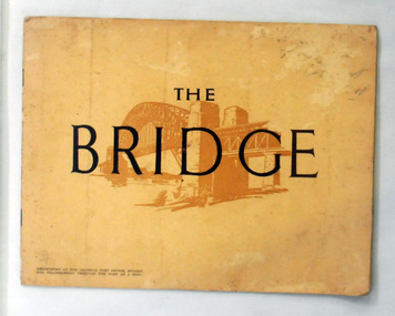
book, The Bridge, 1930's
This book was written by Dr J. J. C. Bradfield, (John Job Crew), 1867-1943. Dr JJC Bradfield was a visionary Australian engineer who worked with enormous energy and vision to build the infrastructure which he foresaw that Sydney would need as it grew. As early as 1903 Bradfield was making the case for the Sydney Harbour Bridge, in his presidential address as President of the Sydney University Engineering Society. Bradfield’s proposal — at that stage for a cantilever bridge between Dawes Point and Milsons Point — won the committee’s support and they recommended it be accepted. However, the First World War put a stop to these plans. While a bill to authorise the project passed the lower house of the NSW parliament in 1916, it failed to pass the upper house, on the grounds that funds should not be diverted from the war effort. With the war over, in 1922 the Sydney Harbour Bridge Act was passed by the NSW Parliament. The Sydney Harbour Bridge was officially opened in 1932 after Museum and St James railway stations were built. This book was written from the story broadcast by Dr. J.J.C. Bradfield. This item is a useful reference tool.A staple soft cover 16 pp booklet with a buff coloured cover. It has a sketch of the Sydney Harbour Bridge behind the title "The Bridge" in dark brown print. It contains information and photographs of the history and construction of Sydney Harbour Bridge.sydney-harbour-bridge bradfield-dr-j-j-c -
 Marysville & District Historical Society
Photograph (Item) - Black and white photograph, Unknown
A copy of a black and white photograph of the bridge over the Steavenson River.A copy of a black and white photograph of the bridge over the Steavenson River. The Steavenson River is named after the Victorian Assistant Commissioner of Roads and Bridges, John Steavenson who arrived in Victoria in the early 1860s.marysville, victoria, steavenson river, photograph, john steavenson -
 Marysville & District Historical Society
Photograph (Item) - Colour photograph, Pre 2009
A colour photograph of the Wilks Creek Bridge near Marysville in Victoria.A colour photograph of the Wilks Creek Bridge near Marysville in Victoria. The Wilks Creek Bridge is a former timber and bluestone road bridge on the Yarra Track, and is located just off the Black Spur route, between Narbethong and Marysville, Victoria, Australia. It was built in 1870 to the design of colonial Public Works Department engineer Clement Wilks as part of the construction of a new road to the Woods Point and Jordan Goldfields. Like many bridges of the period, it had a timber superstructure employing squared beams supported by struts and straining pieces, on cut bluestone abutments. The bridge was remodelled around 1900 by engineer John Monash of the famous bridge-engineering firm of Monash and Anderson. It was last used for heavy vehicular traffic in 1980 following the realignment of Marysville Road, and was left to decay until its demolishment in 2008. All timber traces of the bridge were destroyed in the 2009 Black Saturday fires. The handcrafted bluestone masonry wingwalls and abutments, especially shaped to receive timber struts, rate among the earliest of its kind surviving intact in Victoria.wilks creek bridge, yarra track, narbethong, marysville, victoria, clement wilks, wood's point goldfields, jordan goldfields, john monash, monash and anderson, 2009 black saturday bushfires