Showing 1020 items
matching collection point
-
 Flagstaff Hill Maritime Museum and Village
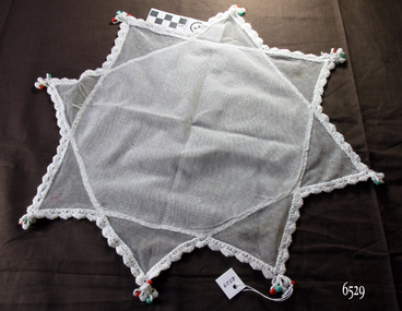
Textile - Jug Cover, ca 1910
The jug cover was made by diagonally overlapping two squares of net fabric and stitching them together. The beads on the cover are used to weigh the cover down and keep it on the jug. In the Words of donor, Betty Stone, … “These crocheted and embroidered articles cover a period of three generations- ie. Sarah (nee Chamberlain) Lees, Ann (nee Lees) Dale, and Daisy Elvena (nee Dale) Welsh. All three were accomplished needlewomen; also, both Sarah Lees (born 1844) and her daughter, Ann (b 1865) crocheted a wide variety of articles for use in their homes. A few examples of these items have survived the years.” It was a tradition for brides to have a 'glory box' containing linen and embroidered articles to take to their new home. Many of the items were made by Daisy, a skilled dressmaker. Daisy began her apprenticeship at two shillings and sixpence per week at Miss A. E. Emery's dressmaking establishment at 150-152 Liebig Street, Warrnambool. Considered to be the leading house of fashion in Warrnambool, Miss Emery employed about eight young women who worked long hours to sew elaborate gowns for clients, including wives of graziers who would attend the race carnivals and social functions in Warrnambool. (NOTE: For additional information please refer to my book Pioneer and Places- A History of Three Warrnambool Pioneering Families ie. Chamberlain, Dale and Lees families)This item is associated with the Warrnambool pioneer families of Chamberlain, Dale and Lees. These families are listed in the Pioneers' Register for Warrnambool Township and Shire, 1835-1900, published by A.I.G.S. Warrnambool Branch. The item is significant for its association with a ‘glory box’ or hope chest, a tradition of single ladies making and collecting a range of linen and other domestic items in preparation for their future marriage. The item is a fine example of early 20th-century needlework and handmade domestic items.Jug cover; net fabric eight-point star shape, with white crocheted edges and red, white and green beads on each point. Part of the Chamberlain Dale Lees Collection.flagstaff hill, warrnambool, flagstaff hill maritime museum and village, great ocean road, chamberlain family, dale family, lees family, betty stone, warrnambool pioneer, warrnambool genealogy, wangoom, chamberlain dale lees collection, glory box, handmade, craft, manchester, linen, haberdashery, needlework, crochet, miss a.e. emery dressmaker, jug cover, beaded cover, beaded jug cover -
 Flagstaff Hill Maritime Museum and Village
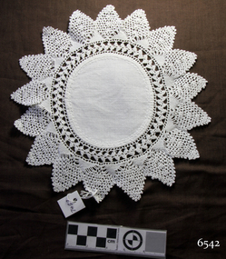
Textile - Doily, ca. 1910
This doily is typical of items of household linen in popular use in the 19th and early-to-mid 20th centuries. It was a tradition for brides to have a 'glory box' containing linen and embroidered and crocheted articles to take to their new home. In the Words of donor, Betty Stone, … “These crocheted and embroidered articles cover a period of three generations- ie. Sarah (nee Chamberlain) Lees, Ann (nee Lees) Dale, and Daisy Elvena (nee Dale) Welsh. All three were accomplished needlewomen; also, both Sarah Lees (born 1844) and her daughter, Ann (b 1865) crocheted a wide variety of articles for use in their homes. A few examples of these items have survived the years.” (NOTE: For additional information please refer to my book Pioneer and Places- A History of Three Warrnambool Pioneering Families ie. Chamberlain, Dale and Lees families) This item is associated with the Warrnambool pioneer families of Chamberlain, Dale and Lees. These families are listed in the Pioneers' Register for Warrnambool Township and Shire, 1835-1900, published by A.I.G.S. Warrnambool Branch. The item is a fine example of early 20th-century needlework. Doily,; white cotton fabric circle with crocheted 17 point star shape border. From the Chamberlain Dale Lees Collectionflagstaff hill, warrnambool, flagstaff hill maritime museum and village, great ocean road, chamberlain family, dale family, lees family, betty stone, warrnambool pioneer, warrnambool genealogy, wangoom, chamberlain dale lees collection, glory box, doily, needlework, crochet, handmade, craft, manchester, linen, haberdashery -
 Flagstaff Hill Maritime Museum and Village
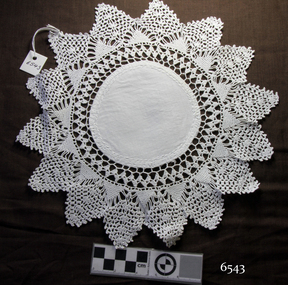
Textile - Doily, ca. 1910
In the Words of donor, Betty Stone , … “These crocheted and embroidered articles cover a period of three generations- ie. Sarah (nee Chamberlain) Lees, Ann (nee Lees) Dale, and Daisy Elvena (nee Dale) Welsh. All three were accomplished needlewomen; also, both Sarah Lees (born 1844) and her daughter, Ann (b 1865) crocheted a wide variety of articles for use in their homes. A few examples of these items have survived the years.” Baby's Crocheted Bonnet - This finely crocheted bonnet was made by Sarah (nee Chamberlain) Lees and is at least one hundred years old. Due to the condition of the original ribbon ties, they have been replaced with new ribbon. Table Runner with insertions, Tray cover and various Doylies, sauce bottle covers etc. - These articles were made by Sarah Lees or her daughter Ann (nee Lees) Dale. Pair of Embroidered Pillow Shams, and various embroidered mats - These items were made by my mother Daisy (nee Dale) Welsh. (NOTE: For additional information please refer to my book Pioneer and Places- A History of Three Warrnambool Pioneering Families ie. Chamberlain, Dale and Lees families) This item is associated with the Warrnambool pioneer families of Chamberlain, Dale and Lees. These families are listed in the Pioneers' Register for Warrnambool Township and Shire, 1835-1900, published by A.I.G.S. Warrnambool Branch. The item is a fine example of early 20th-century needlework.Doily; round white cotton fabric centre with wide crocheted border of 15 point star shape. From the Chamberlain Dale Lees Collectionflagstaff hill, warrnambool, flagstaff hill maritime museum and village, great ocean road, chamberlain family, dale family, lees family, betty stone, warrnambool pioneer, warrnambool genealogy, wangoom, chamberlain dale lees collection, glory box, doily, needlework, crochet, handmade, craft, manchester, linen, haberdashery -
 Federation University Historical Collection
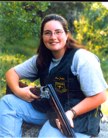
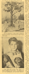
Photograph - colour, Nessa Jenkins
Nessa Jenkins was born at Ararat in 1980. She was a student of the University of Ballarat. At the 2002 Manchester Commonwealth Games Nessa Jenkins won the Women's Trap Pairs and was 5th in the Shooting Women's Trap. "At the 2002 Manchester Commonwealth Games Nessa Jenkins and Diane Reeves took gold from England by one point. The National Shooting Centre in Bisley provided the scene for some thrilling entertainment the Australian pair of Nessa Jenkins and Diane Reeves completed a hat trick of victories in world-class shooting events. Jenkins said: “I’m wrapped – the hardest thing is that you are trying to shoot your own score, but you’re still thinking about what your partner’s shooting, and I could hear Di calling for her targets. Sometimes you can hear the buzzer if someone misses and I didn’t hear it so I thought things were okay.” “We’ve had a lot of competition practice before coming to the Commonwealth Games – we’ve been to the World Cup and the World Championship so it’s been a big build up, but this just topped it off today.”(http://m2002.thecgf.com/Sports/Shooting/News/default.asp?id=579&folder=Shooting, accessed 07/08/2014) Colour photograph of Nessa Jenkins.jessa jenkins, commonwealth games, manchester, trap shooting -
 Federation University Historical Collection
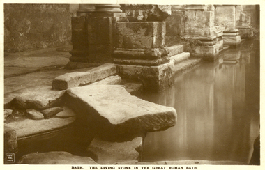
Postcard - Sepia, The Diving Stone in the Great Roman Bath, Bath, Somerset
The Great Bath is a massive pool, lined with 45 sheets of lead, and filled with hot spa water. It once stood in an enormous barrel-vaulted hall that rose to a height of 40 metres. For many Roman visitors this may have been the largest building they had ever entered in their life. The bath is 1.6 metres deep, which was ideal for bathing, and it has steps leading down on all sides. Niches around the baths would have held benches for bathers and possibly small tables for drinks or snacks. A large flat slab of stone is set across the point where hot water flows into the bath. It is known today as the diving stone. The Roman Baths complex is a site of historical interest in the English city of Bath. The house is a well-preserved Roman site for public bathing. The Roman Baths themselves are below the modern street level. There are four main features: the Sacred Spring, the Roman Temple, the Roman Bath House and the Museum, holding finds from Roman Bath. The buildings above street level date from the 19th century. Sepia postcard of a section of the Great Roman Bath at Bath, Somerset featuring the Diving Stone.printed verso: The Diving Stone in the great roman bath. The Diving stone, at the north-west corner of the great Roman Bath, still shows where the feet of bygone bathers wore away its surface. The hot mineral waters flowed into the bath through a channel under this stone. chatham-holmes family collection, bath, great roman bath, swimming pool -
 Federation University Historical Collection
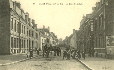
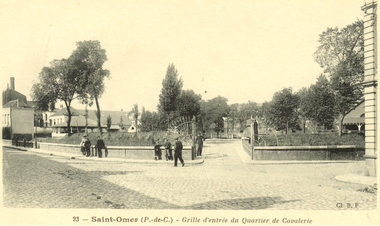
Postcard - black and white, Saint-Omer - Le Rue de Calais, c1913
Saint-Omer is a commune and sub-prefecture of the Pas-de-Calais department 68 km west-northwest of Lille on the railway to Calais. The town is named after Saint Audomar, who brought Christianity to the area. (Wikipedia) During World War I on 8 October 1914, the British Royal Flying Corps (RFC) arrived in Saint-Omer and a headquarters was established at the aerodrome next to the local race course. For the following four years, Saint-Omer was a focal point for all RFC operations in the field. Although most squadrons only used Saint-Omer as a transit camp before moving on to other locations, the base grew in importance as it increased its logistic support to the RFC. Many Royal Air Force squadrons can trace their roots to formation at Saint-Omer during this period. Among which are No. IX Squadron RAF which was formed at Saint-Omer, 14 December 1914 and No. 16 Squadron RAF which was formed on 10 February 1915. (Wikipedia)Black and white postcard showing a group of children and some adults surrounding a horse drawn cart. The cobble stone street is lined with double story buildings. chatham-holmes family collection, saint-omer, world war, world war 1, postcard -
 Federation University Historical Collection
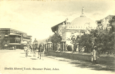
Postcard - black and white, Sheikh Ahmed Tomb, Steamer Point, Aden, c1914
Aden is a seaport city in Yemen, located by the eastern approach to the Red Sea (the Gulf of Aden), some 170 kilometres east of Bab-el-Mandeb. Aden was the capital of the People's Democratic Republic of Yemen until that country's unification with the Yemen Arab Republic. On that occasion, the city was declared a free trade zone.[citation needed] Aden gives its name to the Gulf of Aden. (Wikipedia)Black and white postcard showing Sheikh Ahmed's Tomb at Steamer Point, Aden. A number of camels are walking down the road. chatham-holmes family collection, aden, sheikh ahmed tomb, postcard, hotel de l'europe -
 Federation University Historical Collection
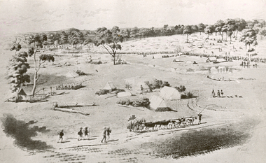
Photograph - Photograph - black and white, William Strutt, View of Golden Point, Ballarat, Taken from West
The lithograph is held by the State Library of Victoria. Printed below the image is Lithographed by Campbell & Macartney. The title is beneath image and continues: 'Respectfully dedicated to the inhabitants of Victoria / By their obedient servant / Wm. Strutt.'Photograph of a lithograph of view of the Golden Point - Ballarat by William Strutt. The Golden Point goldfield at Ballarat is depicted with a number of people congregated along a creek (Yarrowee Creek), some tents, stockyards evident, a butcher's shambles (tent) a bullock dray, three aborigines and a number of 'diggers' walking towards the goldfield are evident.ballarat, golden point, william strutt, ballarat townscape, mining, goldfield -
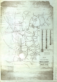 Federation University Historical Collection
Plan, Plan of Leads and Gold Workings at Baallarat Shewing the Complications Under the Frontage System, 1863, 1863
Facsimile of a plan held by the Public Record Office Victoria. Facsimile of a plan of Ballarat showing leads, gold workings an dthe frontage system.ballarat, mining, inkermann lead, golden point lead, robert davidson, terrible lead, white horse lead, frenchman's lead, little magpie lead, milkmaid's lead, woolshed lead, nuggety lead, blackman's lead, canadian lead, sailor's gully lad, nightingale lead, malakoff lead, black hill gully, pennyweight flat, black hill, winter's pre-emptive right, nelson company, great extended, great republic lead, cgt -
 Federation University Historical Collection
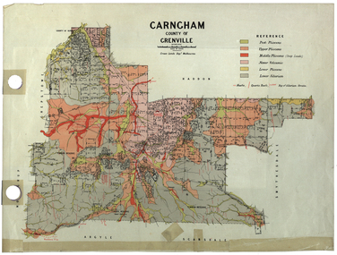
Plan, Carngham, County of Grenville
A plan of Carngham, Victoria.snake valley, timber reserve, poverty point, recreation reserve, carngham, county of ripon, county of grenville, plan -
 Federation University Historical Collection
Equipment - Scientific Object, Test Tube Holder
This item was removed from the Mt Helen Campus S-Building before refurbishment in September 2015.A wooden test tube holder. It has cut circles in the structure to hold upright test tubes (those in use) and pieces of dowel to hold upside down test tubes (those in storage or drying). The word ananlite is engraved in the wood at the front. There are pen markings of numbers next to some of the holes and some of the pieces of dowel. The words water and lime are also written in pen, with arrows pointing towards, next to one of the end holes. test tube holder, test tubes, science, scientific equipment, laboratory -
Federation University Historical Collection
Plan, R. Underwood, Shire of Winchelsea, 1952, 10/10/1952
Copy of a plan of the Shire of Winchelsea including Lake Wollard, Wormbete, angahook, boonah, Barwon Downs, Kaanglang, St Gerge River, Cumberland Creek, Stony Creek, Bambra, Wensleydale, yan Yan Gurt, Tutegong, Mirnee, Karngun, whoorel, Birregurra, Barwon River, Thompson's Creek, Bass Straight. Mt Defiance, Mt St George, Loutit Bay, Airey's Inlet, Salt Creek, Mathew's Creek.winchelsea, lake wollard, wormbete, angahook, boonah, barwon downs, kaanglang, st george river, cumberland creek, stony creek, bambra, wensleydale, yan yan gurt, tutegong, mirnee, karngun, whoorel, birregurra, barwon river, thompson's creek, bass straight. mt defiance, mt st george, loutit bay, airey's inlet, salt creek, mathew's creek, r. underwood, why river, point sturt, barwon downs, forest -
Federation University Historical Collection
Letter, Letter from National Service Recruit, 1969, 1969
A letter regarding National Service recruit training at the Army's camp at Puckapunyal. The letter is thought to be directed to former classmates at the Ballarat Technical School, a division of the Ballarat School of Mines. This letter relates to Australian Commonwealth National Service training at Puckapunyal.Two paged letter on small lined paper, written in ball point pen. The letter is written to Kevin, and is signed by Peter Davis.recruit, national service, training, ballarat technical school, peter davis, puckapunyal -
 Federation University Historical Collection
Newsclips
Newspaper clipping about the gaol tree at Ballaratkeith rash, douglas rash, bill young, post office hill, logs, gaol tree, golden point -
 Federation University Historical Collection
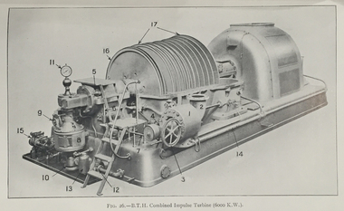
Book, William J. Goudie, Steam Turbines, 1922, 1922
Green hard covered bookInside front cover "R.F. Symons Holmby Lodge Point Nepean Road Cheltenham"steam, r.f. symons -
 Federation University Historical Collection
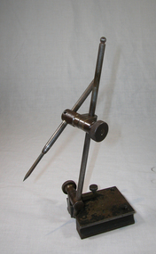
Object, Brown and Sharpe Manufacturing Co, Universal Surface Gauge
Used to lay out Machine work, or to set up pieces on a planer, radial drill, milling machine or boring machine. To set the Scriber the spindle swivels down or up into any position where it is clamped by the knurled nut. There is a fine screw adjustment for the Scriber point (note: this is not original Scriber supplied with this instrument). The base on this Surface Gauge can be set on cylindrical work, using the ‘V’ groove in the base, or by pushing down the two gauge pins. It can be brought square with an edge or T slot. Metal gauge toolgauge, tool, trade, brown and sharp manufacturing company -
 Federation University Historical Collection
Postcards - black and white, Saint-Omex, France, c1916
During the First World War on 8 October 1914, the British Royal Flying Corps (RFC) arrived in Saint-Omer and a headquarters was established at the aerodrome next to the local race course. For the following four years, Saint-Omer was a focal point for all RFC operations in the field. Although most squadrons only used Saint-Omer as a transit camp before moving on to other locations, the base grew in importance as it increased its logistic support to the RFC. Many Royal Air Force squadrons can trace their roots to formation at Saint-Omer during this period. Among which are No. IX Squadron RAF which was formed at Saint-Omer, 14 December 1914 and No. 16 Squadron RAF which was formed on 10 February 1915. (http://en.wikipedia.org/wiki/Saint-Omer, accessed 14/07/2014) During World War II, the Luftwaffe used the airfield. When the RAF's legless Battle of Britain ace, Douglas Bader, parachuted from his Spitfire during an aerial battle over France, he was initially treated at a Luftwaffe hospital at Saint Omer. He had lost an artificial leg when bailing out, and the RAF dropped him another one during a bombing raid.(http://en.wikipedia.org/wiki/Saint-Omer, accessed 14/07/2014)Four postcards of Saint Omer in Francechatham-holmes family collection, saint omer, france, ww1, postcard -
 Federation University Historical Collection
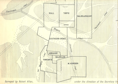
Plan, Underground Survey of Mines, Ballarat East, 1885, 09/1889
Surveyed by Robert Allan under the direction of the Secretary of Mines.Rectangular plan showing placement of mines in 1889. Mines include Hick's and Gilpin's lease, Comstock, Melbourne Company, Victoria United, Speedwell Company, New Normanby, Pasha Surprise, Central Sulieman, West Llanberris, Britannia United, Victoria Unites, Clinton's, Orient Company, North Sulieman, Sulieman Extended, Pasha Surprise, Golden Fountain, Prince regent, Clark and Company, Tinworth, North Woah Hawp, Detering, R.A. Thompson, Dazelles and buchanan, Barnett, Braybrook, Ladt Cornwall, Hanthorne, Dalzelles and gay, Southern Cross, M. Acheson, Cricket Reserveballarat east, mines, mining, underground survey, robert allan, chinese, ah chong, ah young, bakery hill, black hill, black hill lead, bakery hill lead, cricket, pennyweight hill, gravel pitts lead, golden point lead, navy jack's lead, mopoke lead, eureka lead, association lead, warrenheip lead, cgt, plans -
 Federation University Historical Collection
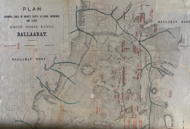
Plan, White Horse Range Ballarat, 1885, 06/1885
Two plans .1) Plan of the Ballarat Goldfields showing leads, rivers, streets and topography. Quartz reefs include: Yorkshire, Try Again, Promised Land, Western Slates, Norwegian, Robert's Lode, Finn's, Band and albion, Rothschild, Old Post Office, Queen Lode. Leads include: Navy jacks, Gays, Canadian, Prince Regent, Sailors Gully, White Horse, Little White Horse, Milkmans, Nightingale, Golden Point, Gravel Pits. Scale is 8 Chains to 1 inch .2) Plan showing lines of quartz reefs, alluvial workings and leads, White Horse Range, Ballarat. Leads include White Horse LEad, Little White Horse Lead, One Eye Gully, Terrible Lead, Sailor's Gully, Canadian Lead, Prince Regent Gully, Canadian Lead, Cavs Lead, Navy jacks Lead, Eureka Lead, Old Gravel Pits Lead, Gravel Pits Lead, Nightingale Lead, Malakoff Lead, Milkmans Lead, Redan Lead, Woolshed Lead, Jacksons Lead, Winters Lead, SCtochman's Lead, Canadian Lead. Reefs include: Promised Land, Daniash, Sir Garnet Wolsley, Norwegian, Rothschile, Band and Albion, Finns, Llanberis, Roberts Lode, Tynworths and Black Hill, Oregan, Yorkshire, Try Again, Yorkshire, Post Office, Clarke's, Western Slates, Black Slate, Danks Slates, Eastern Slates, Queen's Lode, Fire Brigade. Mines include Red Streak, New Chum, Tinworths, Woah Hawp, Normanby, Speedwell, Llanberris Extended, Llanberis, Last Chance, Major, Countess, Pioneer and a number of batteries along Main Road Hills include: Mount Clear, Pennyweight Hill, Sovereign Hillballarat, plan, white horse range, white horse, goldfields, mines, reefs, indicators, leigh river, cgt, tinworth, mining -
 Federation University Historical Collection
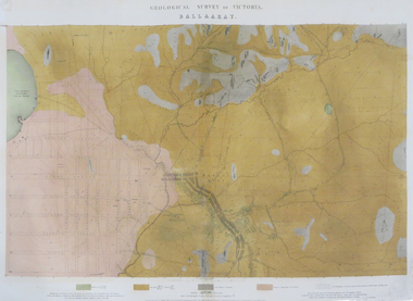
Map - Map - Geological, Ballarat, 1858, 10/1858
Four colour geological map of Ballarat.map, ballarat, geology, black hill, golden point, povery point -
 Flagstaff Hill Maritime Museum and Village
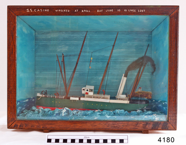
Craft - Ship Model, S.S. Casino
Ship model of coastal trader SS Casino in glass fronted case with stained wood frame. Ship has both steam and sail. Background of lighthouse on cliff, sea and sky. Ship painted green, 3 flags flying. Details (incorrect) of ship painted in white across top frame of case. The S.S. Casino was a passenger and freight steamer built in Dundee, Scotland, in 1882 for the Newcastle and Hunter River Steam Navigation Company of N.S.W. She weighed 425 tons gross with a length of 160.4 feet, beam of 24.1 feet and depth of 10.2 feet. She had saloon accommodation for 35 people, forecabin for 25 more people, and she carried 300 tons of cargo. While on her delivery journey on May 30th 1882 the S.S. Casino called in at the Port of Warrnambool for coal ., narrowly escaping going ashore in gale force winds due to the quick action of the pilot. At that time, still at anchor, she impressed the directors of the Belfast and Koroit Steam Navigation Company so much that they bought her immediately; she was ideal for trade in along the West Coast of Victoria. (Belfast is the original name for Port Fairy, South West Victoria. The Belfast and Koroit Steam Navigation Company was first managed by Messers. Saltau and Osburne and after the passing of Mr. Osburne, by produce merchants Messers H. Sautau and Sons, whose had a hay and corn store and shipping agency was on the corner of Liebig and Koroit Streets in Warrnambool. ) The S.S. Casino became “the most famous steamer to operate in Victorian waters along the West Coast” by author Jack Loney. Captain Boyd was her first Master, followed by Captain Chapman, who stayed with her 1890 until 1924. Captain W. Robertson followed for a short term, then Captain Middleton then took command 1925 - 1932. The S.S. Casino had several mishaps during her life. One was on 3rd January 1898 when she collided with the S.S. Flinders in Apollo Bay with minor damage. Another was on 24th October 1924 when she grounded on a reef at Point Hawdon near Grey River and most of her cargo (of Christmas goods) had to be dumped into the sea. Then in February 1929 she was ‘holed’ when she struck a submerged object as she entered Lady Bay, Warrnambool. On the morning of 10th July 1932, after attempting to berth at Apollo Bay jetty in heavy seas, Captain Middleton decided to take her out into the bay and wait until the seas abated. It was not realised that the anchor used to steady her as she manoeuvred to her berth had pierced her hull. She put about and headed for the beach but sank. Captain Middleton and nine others lost their lives; nine people were rescued including the two female passengers . Captain Middleton had been in charge of the S.S. Casino for seven years. He was the first ship’s Master to lose his life through shipwreck in the West Coast trade. In the years following the turn of the century the S.S. Casino remained the only regular trader with normal passenger accommodation along the West Coast. From 1882 she had made at least 2,500 voyages on the one run. Flagstaff Hill’s collection has a photograph of a portrait of Captain Chapman, , a ship model of the S.S. Casino that shows both forms of power under which she sailed, steam and sail. The ship is painted green and flies three flags. The inscription across the case of the ship model, incorrectly dated, tells the sad story of the wreck of the ship and the loss of lives on July 10th 1932 at Apollo Bay. A print in the Collection show S.S. Casino underway in heavy sea off Point Lonsdale, another two photographs show her at the Port of Warrnambool, leaving from the Breakwater in Lady Bay and another identifies the S.S. Casino as a ship from the Belfast and Koroit Steam Navigation Company. (Belfast is the original name for the township of Port Fairy). This ship model is significant because of its association with the coastal trader S.S. Casino 1882-1932 and its significance to trade along Victoria's West Coast in the late 19th and early 20th century. The wreck of the S.S. Casino is considered an important part of Victorian and Australian cultural heritage and as such has been declared and protected as an Historic Shipwreck under State and Commonwealth Law in the Commonwealth Historic Shipwrecks Act (1976). Ship model SS Casino in glass fronted case with stained wood frame. Ship has both steam and sail. Background of lighthouse on cliff, sea and sky. Ship painted green, 3 flags flying. Details of ship painted in white across top frame of case. NOTE: Correct details for shipwreck is 10 July 1932, at Apollo BayPainted in white on wood across top of case "SS CASINO WRECKED AT APOLL BAY JUNE 10 10 LIVES LOST".flagstaff hill, warrnambool, shipwrecked coast, flagstaff hill maritime museum, maritime museum, shipwreck coast, flagstaff hill maritime village, great ocean road, newcastle and hunter river steam navigation company, belfast and koroit steam navigation company, h. sautau and sons, s.s. casino, west coast trader s.s. casino, victorian coastal trader, captain boyd, captain w. robertson, captain chapman, captain middleton, apollo bay shipwreck, s.s. casino at lady bay warrnambool, ship model s.s. casino, saltau and osburne -
 Federation University Historical Collection
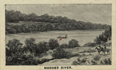
Photograph (black & White), Modder River - South Africa
When war broke out in 1899, and early target for the Boers was the diamond-mining centre of Kimberley. This was located near the point where the Transvaal, Orange Free State and Cape Colony met. General Sir Redvers Buller detached the 1st Division under Lieutenant General Lord Methuen to relieve the Siege of Kimberley. This decision was made partly for reasons of prestige. To capture Kimberley (which contained the famous imperialist and former Prime Minister of Cape Colony, Cecil Rhodes) would be a major propaganda victory for the British. Methuen's force advanced north and won two engagements against the Boers of the Orange Free State. Reinforcements from Transvaal under General Koos de la Rey arrived and he convinced the Boers to follow his plans for attacking the British. Instead of relying on the hills for protection and missing their targets, de la Rey proposed they make use of the flat veld and introduced them to the Mauser rifle with its flat trajectory. Trenches were built in the banks of the Modder River from which they could sweep the veld for a great distance. The trenches were built on the south side of the river and on the smaller Riet River where they meet at Modder River Station. Methuen's force began advancing towards the Modder planning to cross the river. The Boers opened fire and the British troops were unable to find cover on the veld. They had to lay flat so as not to be seen or hit. The British guns pounded the buildings near Modder River Station and the north bank of the river, missing the trenches on the south bank. The battle became a stalemate. The British found an opening on the Boer's right flank at Rosmead ford downstream and drove the Boers out of Rosmead. De la Rey drove them back into a small insecure bridgehead. The Boers feared they were vulnerable and withdrew during the night. Methuen reported that the battle had been "one of the hardest and most trying fights in the annals of the British army". Individual image from photographed poster of tobacco and cigarette cards.boers, diamind-mining, kimberley, transvaal, orange free state, cape colony, sir rdvers buller, lieutenant general lord methuen, siege of kimberley, cecil rhodes, general koos dde la rey, mauser rifle, veld, modder river, modder river station, trenches, riet river, rosmead -
 Federation University Historical Collection
Exercise book, Jean Mather, Geology
Brown hardcover exercise book, some handwriting in pencil and some in ink by Jean Mather. These writings describe geological conditions such as faults, goldfields, Reedy Creek (Broadford) and other Goldfields, Maldon Dykes, Bendigo Dykes, Wood's Point, Walhalla-Wood's Point Belt, Sir Donald Douglas Mather, The New Miner's Right (1977), ordivician, gabbro. jean mather, geology, trough faults, bendigo, ballarat, goldfields, dykes, minerolgy, reedy creek goldfield -
Federation University Historical Collection
Reports, Unexplained animal kills and sighting, 1997
The folder or correspondence is the result of a Freedom of Informaition request made to the Department of Sustainability and Environment in 2011. The folder was collected for research being conducted by David Waldron.Folder of reports unexplained animal kills and sighting in VIctoria australian mythical animals collection, david waldron, dse, big cats, panthers pumas, nuggety, gippsland, black cats, tasmanian tiger, marysville, wood's point, thylacine, south gippsland, felid, gippsland big cat, dna, kelvin healey, peter hall, sherbrooke forest, woodside, walaces flat, mountain lion, bairnesdale, heyfield, mt taylor, walhalla, mt selma, warrnambool, tasmanian tiger, kyneton, korumburra, canadian forest, grampians, panton hill, beaconsfield, apollo bay, forrest -
Federation University Historical Collection
Reports, Big Cat sightings (dates), 1989
Research of dated sightngs of Big cats in Victoria from 1868-1989. australian mythical animals collection, david waldron, dse, big cats, panthers pumas, nuggety, gippsland, black cats, tasmanian tiger, marysville, wood's point, thylacine, south gippsland, felid, gippsland big cat, kelvin healey, peter hall, sherbrooke forest, woodside, walaces flat, mountain lion, heyfield, mt taylor, walhalla, mt selma, warrnambool, kyneton, korumburra, canadian forest, grampians, panton hill, beaconsfield, apollo bay, forrest, victoria valley, rapanyup, dargo, inglewood, doncaster east, tidal river, cape bridgewater, walkerville, dooen, st arnaud, lake bung bong, mitta mitta, moliagul, emerald, kinglake, cape otway, dereel, leonard's hill, daylesford, korweinguboora, lal lal, noojee, eltham, lancefield, trentham, daisy hill, tanjil south, wonthaggi, cockatoo, warrenheip, greendale, howqua, lake buchan, melville caves, portland, mt elephant, morwell, navarre, yarram, yandoit, moonambel, maryborough, taravale, coghill's creek, trentham, carisbrook, inglewood, warrenmang, yarragon, creswick, emerald, stawel, clunes, majorca, heathcote, talbot, daylesford, newham, broadford, peter chapple -
 Federation University Historical Collection
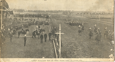
Image, Victorian Headquarters Staff and Visiting Officers, 1901
Victorian Headquarters staff and visiting officers passing the saluting point at Flemington Racecourse. This was part of the Royal Tour by Geaorge V to the British Colonies in 1901. The Duke and Duchess of Cornwall and York were in Melbourne to open the first Parliament of the OCmmonwealth of Australia. armed services, boer war, cadets, volunteer regiments, e.a. daley, george v, toyal visit -
 Federation University Historical Collection
Booklet - Report, J.J. Gourley (Government Printer), Department of Mines Annual Report, 1950, c1950
Thirty six page foolscap booklet with some black and white photographic image. It includs statistics relating to the mining industry. Images include Limestone Quarry at Cave Hill, Lilydale; Golden Retriever nuggett; The Wedderburn Dog nuggett; Moning Star Mine, Wood's Point; shallow drilling; penicillin tanks; Mines Department Laboratory; Charging; Aurora Mine, Daylesford; Hattietville Dredge; North Deborah Mine, Bendigo; Central Victorian Dredge, Strangwaysj.g. gouley, mining, coal, gold, silver, geology, boiler inspection, leasing, gold buyers act, lilydale, fireclay, harrietville dredge, aurora mine daylesford, williams reward mine daylesford, strangways dredge, north deborah mine bendigo, statistics, bendigo mine, department of mines victoria, annual report, statistics relating to mining industry -
Federation University Historical Collection
Book, Northern Territory of South Australia Report Resulting from the Explorations by the Government Geologist, 1906, 1906
Pale blue soft covered geological and general report. It includes a chapter of Bathurst Island and Melville Island, Primitive Methhods of Chinese Mining, Early Days of Mining in the Northern Territory Images include sandbank at low tide, Douglas River, Granite at Union Hill, Night Cliff, East Point, union hill, zapopan gold mine Brook's Creek, Blow Gold Mine Yam Creek, Daly River Copper Mine, Mount Ellison Copper Mine, Point Charles Lighthouse, Blacks Camp near Point Charles Lighthouse, The Venture Stranded on a Daly River Sandbank, Hyland Bay Natives, Boabab Trees at Blunder Bay, The Wai Hoi, Mouth of Fitzmaurice River, Point Blaze Natives, Fort Hill and Old Gulnare Jetty Port Darwin, Large Anthill, Daly RIver Natives, Wargie Natives, L.C.E. Gee, H.Y.L. Brown, H. Basedow. F.J. Williamson, Aboriginal crew (Pedro, Peter, Tobatchie, Bubs, Loman), Henry Roberts, Schollert's Grave It also includes a large folder Geological Map of the North-Western District Northern Territory of South Australia. northern territory of south australia, geology, l. o'loughlin, douglas river, bathurst island, melville island, apsley straight, chinese, aboriginal -
 Federation University Historical Collection
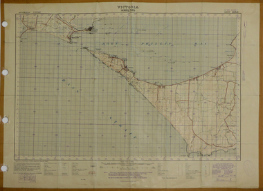
Map, Sorrento, 1931, 03/1931
Printed colour map on paper showing Sorrento and surroundssorrento, point nepean, point lonsdale, queenscliff, port phillip bay -
 Federation University Historical Collection
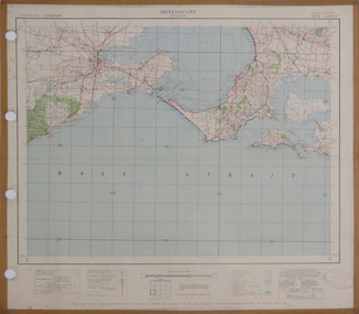
Map, Queenscliff, 1942, 1942
Two copies of printed colour map on paper showing Queenscliff and surrounds"This map in an official document, if found, it must be handed in to the nearest military headquarters or police station."queenscliff, portsea, point nepean, point lonsdale, barwon heads, geelong, corio bay, port phillip bay