Showing 1562 items
matching documents - maps
-
 Tarnagulla History Archive
Set of Maps (Mining & Local Area), various
... A set of mining documents, maps and plans: 1. Dunolly Deep... of mining documents, maps and plans: 1. Dunolly Deep Leads ...David Gordon Collection. A set of mining documents, maps and plans: 1. Dunolly Deep Leads - showing location and names of deep lead gold deposits in region around Dunolly including at Tarnagulla and Newbridge. Geological Survey of Victoria, Department of Minerals and Energy. Bulletin No. 62, Map No. 4 Dunolly (770 x 485 mm). 2. Poseidon Lead (Facsimile) 3. Nick O Time Lead (Facsimile) 4. Happy Go Lucky Mine prospectus and plan (colour copy) 5. Jones Creek GM Co. (Raven & Gourlay's) Waanyarra - Prospectus (colour copy) 6. Poseidon Area Plan (colour copy) and Poseidon Area map (B&W copy). 7. Cross-section diagram of Spread Eagle Reef 8. New Birthday Gold Mine - area map (colour copy) and mine cross-section ( (colour copy). 9. Cross section of Poverty Reef, by Department of Mines (B&W copy, 2 parts on A2 paper) 10. Time-Lease Graph for Watts Reef, Specimen Reef, Stony Reef, Poverty Reef (second page in detail), created by Eric WIlkinson for Ref Mining NL, 1995 11. 1859 Plan of the Gold Workings & Township of Sandy Creek, Shewing the Mining Leases, Extended Claims & Machinery by R.J. McMillan, Mining Surveyor (B&W copy) 12. Longitundinal and Transverse Vertical Sections of Poverty Reef, Sandy Creek 1859, by R.J. McMillan, Mining Surveyor (B&W copy) 13. Tarnagulla Locality Plan (B&W copy) 14. Universal Grid Reference Map (Topographic) for Laanecoorie North (2 copies) 15. Universal Grid Reference Map (Topographic) for Inglewood South 16. Poverty Reef, Plan showing shafts and early tenements, created by Eric WIlkinson for Ref Mining NL, 1995 17. Locality Map of mining leases in Tarnagulla 18. Plan and Elevation of part of Poverty Reef, Sandy Creek, showing the claims and positions of the shaft. by R.J. McMillan, Mining Surveyor (Facsimile, composed of taped together components) 19.Plan and Elevation of part of Poverty Reef, Sandy Creek, showing the claims and positions of the shaft. by R.J. McMillan, Mining Surveyor (Facsimile, composed of taped together components) -
 Kew Historical Society Inc
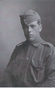
Photograph - Photograph [copy], Pte. Charles Field Richardson, 1914, 1914
... , photographs, maps, and documents were sourced by her from both family..., maps, and documents were sourced by her from both family ...This work forms part of the collection assembled by the historian Dorothy Rogers, that was donated to the Kew Historical Society by her son John Rogers in 2015. The manuscripts, photographs, maps, and documents were sourced by her from both family and local collections or produced as references for her print publications. Many were directly used by Rogers in writing ‘Lovely Old Homes of Kew’ (1961) and 'A History of Kew' (1973), or the numerous articles on local history that she produced for suburban newspapers. Most of the photographs in the collection include detailed annotations in her hand. The Rogers Collection provides a comprehensive insight into the working habits of a historian in the 1960s and 1970s. Together it forms the largest privately-donated collection within the archives of the Kew Historical Society.A half length portrait of Charles Richardson, the brother of the historian Dorothy Rogers, who enlisted in 1914. Pte. Charles Field Richardson fought and was wounded at Gallipoli. He died of his wounds in Alexandria after being wounded at Gallipoli.pte. charles field richardson, charles richardson, world war one -
![State Funeral [for] The Late The Honourable Sir Wilfrid Kent Hughes K.B.E. M.V.O. M.C. E.D. M.P., 1970](/media/collectors/550653872162f11fb04854aa/items/57d0a514d0cdeb1c1046b436/item-media/57d0a581d0cdeb1c1046f625/item-fit-380x285.jpg) Kew Historical Society Inc
Kew Historical Society IncProgramme - Order of Service, Commonwealth of Australia, State Funeral [for] The Late The Honourable Sir Wilfrid Kent Hughes K.B.E. M.V.O. M.C. E.D. M.P., 1970, 1970
... in 2015. The manuscripts, photographs, maps, and documents were..., photographs, maps, and documents were sourced by her from both family ...A resident, and parliamentary representative of Kew, Wilfred Kent Hughes was elected to the Victorian Parliament in 1927. He switched to federal politics in 1949 and remained an MP until his death in 1970. This work forms part of the collection assembled by the historian Dorothy Rogers, that was donated to the Kew Historical Society by her son John Rogers in 2015. The manuscripts, photographs, maps, and documents were sourced by her from both family and local collections or produced as references for her print publications. Many were directly used by Rogers in writing ‘Lovely Old Homes of Kew’ (1961) and 'A History of Kew' (1973), or the numerous articles on local history that she produced for suburban newspapers. Most of the photographs in the collection include detailed annotations in her hand. The Rogers Collection provides a comprehensive insight into the working habits of a historian in the 1960s and 1970s. Together it forms the largest privately-donated collection within the archives of the Kew Historical Society.Handout - "State Funeral. The Late The Honourable Sir Wilfrid Kent Hughes K.B.E. M.V.O. M.C. E.D. M.P. Order of Service at St John's Anglican Church, Burke Road, Camberwell. Monday, 3rd August 1970, at 11.00 a.m."wilfred kent hughes, funeral services, federal politicians -- kew (vic) -
![State Funeral [for] The Late The Honourable Sir Wilfrid Kent Hughes K.B.E. M.V.O. M.C. E.D. M.P., 1970](/media/collectors/550653872162f11fb04854aa/items/57d0a860d0cdeb1c104871a2/item-media/57d0a87ad0cdeb1c104878ec/item-fit-380x285.jpg) Kew Historical Society Inc
Kew Historical Society IncProgramme - Order of Service, Commonwealth of Australia, State Funeral [for] The Late The Honourable Sir Wilfrid Kent Hughes K.B.E. M.V.O. M.C. E.D. M.P., 1970, 1970
... in 2015. The manuscripts, photographs, maps, and documents were..., photographs, maps, and documents were sourced by her from both family ...A resident, and parliamentary representative of Kew, Wilfred Kent Hughes was elected to the Victorian Parliament in 1927. He switched to federal politics in 1949 and remained an MP until his death in 1970. This work forms part of the collection assembled by the historian Dorothy Rogers, that was donated to the Kew Historical Society by her son John Rogers in 2015. The manuscripts, photographs, maps, and documents were sourced by her from both family and local collections or produced as references for her print publications. Many were directly used by Rogers in writing ‘Lovely Old Homes of Kew’ (1961) and 'A History of Kew' (1973), or the numerous articles on local history that she produced for suburban newspapers. Most of the photographs in the collection include detailed annotations in her hand. The Rogers Collection provides a comprehensive insight into the working habits of a historian in the 1960s and 1970s. Together it forms the largest privately-donated collection within the archives of the Kew Historical Society.Handout - "State Funeral. The Late The Honourable Sir Wilfrid Kent Hughes K.B.E. M.V.O. M.C. E.D. M.P. Order of Service at St John's Anglican Church, Burke Road, Camberwell. Monday, 3rd August 1970, at 11.00 a.m."wilfred kent hughes, federal politicians -- kew (vic.), funeral services, state funerals -
 Kew Historical Society Inc
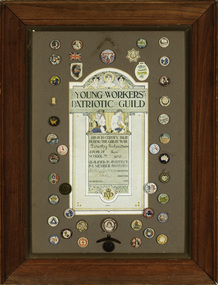
Certificate, Harold Herbert, Young Workers’ Patriotic Guild, 1917
... , photographs, maps, and documents were sourced by her from both family..., maps, and documents were sourced by her from both family ...This item forms part of the collection assembled by the historian Dorothy Rogers, that was donated to the Kew Historical Society by her son John Rogers in 2015. The manuscripts, photographs, maps, and documents were sourced by her from both family and local collections or produced as references for her print publications. Many were directly used by Rogers in writing ‘Lovely Old Homes of Kew’ (1961) and 'A History of Kew' (1973), or the numerous articles on local history that she produced for suburban newspapers. Most of the photographs in the collection include detailed annotations in her hand. The Rogers Collection provides a comprehensive insight into the working habits of a historian in the 1960s and 1970s. Together it forms the largest privately-donated collection within the archives of the Kew Historical Society.An important item of mixed-media commemorating a child's participation in fundraising during the First World War. Dorothy Richardson's brother died in Alexandria after being wounded at Gallipoli. This item formed part of a larger collection comporting service in World War 1.Young Workers’ Patriotic Guild commemorative certificate. The certificate was awarded to Dorothy Richardson, a pupil of Kew Primary School. Forty-two buttons, created to support the war effort, surround the certificate. The Young Workers’ Patriotic Guild was formed in Victorian schools in 1916. Each child who raised one pound ‘by personal productive effort’ received a certificate. The money was used for the war effort. [Dorothy Richardson is better known as the historian Dorothy Rogers].young workers patriotic league, world war 1, first world war, department of education -- victoria, dorothy richardson, dorothy rogers, rogers collection, wwi -
 Melbourne Tram Museum
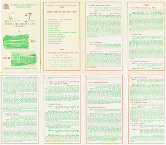
Pamphlet, Melbourne & Metropolitan Tramways Board (MMTB), "Short Trips around Melbourne and Suburbs by Bus and Tram", mid 1960's
... and bus routes - from map date document mid to late 1960's - old... - from map date document mid to late 1960's - old route numbers ...Pamphlet titled "Short Trips around Melbourne and Suburbs by Bus and Tram", two colour printed document folded into 8 on buff coloured paper, featuring 14 various trips around Melbourne, with a detailed description of each route, time, fare and notes. On reverse side is a detailed map of the MMTB tram and bus routes - from map date document mid to late 1960's - old route numbers eg 4D and Point Ormond and Footscray have closed. See also Reg Item 1508 for an earlier version.trams, tramways, mmtb, map, tourist trips, fares, routes -
 Kew Historical Society Inc
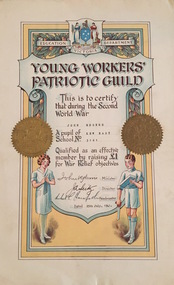
Certificate, Education Department (Victoria), Young Workers Patriotic Guild, 1941, 1941
... in 2015. The manuscripts, photographs, maps, and documents were... in 2015. The manuscripts, photographs, maps, and documents were ...The Young Workers Patriotic Guild was originally established in World War I and reestablished in World War II. The Collection includes a number of items produced under this banner from both the First and Second World Wars. This work forms part of the collection assembled by the historian Dorothy Rogers, that was donated to the Kew Historical Society by her son John Rogers in 2015. The manuscripts, photographs, maps, and documents were sourced by her from both family and local collections or produced as references for her print publications. Many were directly used by Rogers in writing ‘Lovely Old Homes of Kew’ (1961) and 'A History of Kew' (1973), or the numerous articles on local history that she produced for suburban newspapers. Most of the photographs in the collection include detailed annotations in her hand. The Rogers Collection provides a comprehensive insight into the working habits of a historian in the 1960s and 1970s. Together it forms the largest privately-donated collection within the archives of the Kew Historical Society.Young Workers Patriotic Guild Certificate - An illuminated Young Workers Patriotic Guild certificate issued by the Education Department Victoria. The certificate testifies that John Rogers who was a pupil at Kew East School raised £1 for War Relief objectives in 1941. young workers patriotic guild, second world war 1939-1945, george rogers -
Glen Eira Historical Society
Letter - Heritage Watch Caulfield
... a committee –dated 27/06/1991, and documents outlining goals, maps... VIC 3162 melbourne This file contains 5 items: 1/Documents ...This file contains 5 items: 1/Documents related to the establishment of Heritage Watch in Caulfield. This includes a typed letter to Mrs. And Mr. Campbell from Graham Walsh inviting them to attend a meeting concerning the potential establishment of Heritage Watch – dated 08/11/1989. A nomination form to elect a committee –dated 27/06/1991, and documents outlining goals, maps of proposed area designated by the council, and black-and-white photographs of Miners Cottage Elsternwick and a mansion in Ripponlea, Elsternwick. 2/Minutes of Caulfield Heritage Watch Committee meetings on 04/12/1999, 22./01/1990, 08/10/1990 and 26/11/1990. It includes aims, general business, publicity and discussion on ‘Rosecraddock’. 3/Caulfield Heritage Watch Newsletter issue number three dated June 1991. It includes a paragraph on Rosecraddock, The Grand Union Tram Junction, Caulfield Heritage Study and an invitation to the annual general meeting on 27/06/1991. 4/Financial statement for Caulfield Heritage Watch for November 1989 to May 1991. 5/A handwritten submission to save Rosecraddock from demolition, date and author unknown.caulfield train station, margaret street 28, walsh graham a., caulfield manor grove 1, shellard mr., labassa, derby road, inkerman road, kerr paul, glen huntly road, victorian houses, gladstone parade, hawthorn road, o’neill college, miners cottage regent street elsternwick, buildings, heritage, preservation, urban conservation policy, caulfield city council, campbell mr. + mrs., caulfield heritage watch committee, snowball b., kay w., spencer d., dustan don, dustan david, campbell f., hill tess, jordan p., ritchie jack, architecture, development, cultural structures and establishments, residential development, murray, wells, hopkins sherry, caulfield town hall, rodder a., caulfield contact, spiker mr., elsternwick railway, elsternwick club, committees and inquiries, meetings, rosecraddock, construction sites, property, hill l., mayoress’ room caulfield, city hall, morris e., feehan j., molony v., moore mrs., elsternwick sandham street 19, elsternwick bowling club, ward andrew, shellard mr., construction and demolition, balaclava road, tramways, tram junction, kerr paul, gardens, save rosecraddock neighbourhood group -
 Kew Historical Society Inc
Photograph - 'Ross House', Cotham Road [Kew], c.1960
... in 2015. The manuscripts, photographs, maps, and documents were... in 2015. The manuscripts, photographs, maps, and documents were ...Ross House, formerly called Charleville, was built as a two-storey mansion in 1889 for Charles Donaldson. It was designed in the Italianate style by the architect H. Shallers and built by G. Ginham. Dr Tom King, surgeon purchased Charleville from Donaldson in 1939 and renamed it Ross House. This work forms part of the collection assembled by the historian Dorothy Rogers, that was donated to the Kew Historical Society by her son John Rogers in 2015. The manuscripts, photographs, maps, and documents were sourced by her from both family and local collections or produced as references for her print publications. Many were directly used by Rogers in writing ‘Lovely Old Homes of Kew’ (1961) and 'A History of Kew' (1973), or the numerous articles on local history that she produced for suburban newspapers. Most of the photographs in the collection include detailed annotations in her hand. The Rogers Collection provides a comprehensive insight into the working habits of a historian in the 1960s and 1970s. Together it forms the largest privately-donated collection within the archives of the Kew Historical Society.Facade of Ross House (formerly Charleville) in Cotham Road, Kew. The image was selected by Dorothy Rogers for inclusion in 'A History of Kew' (1973), facing page 80.Ross House. Built 1889 by Donaldson. Known then as Charleville. Not published.ross house, charleville, cotham road, kew, dorothy rogers, charles donaldson, tom king, g. ginham, h. shallers -
 Kew Historical Society Inc
Photograph, Kew Common School, c. 1863
... John Rogers in 2015. The manuscripts, photographs, maps... John Rogers in 2015. The manuscripts, photographs, maps ...The Kew Common School, which had erected a new building in Peel Street only two years before the passing of the Education Act 1872, was retained and re-badged asState School No 1075, with numerous additions being made over the next few decades. This work forms part of the collection assembled by the historian Dorothy Rogers, that was donated to the Kew Historical Society by her son John Rogers in 2015. The manuscripts, photographs, maps, and documents were sourced by her from both family and local collections or produced as references for her print publications. Many were directly used by Rogers in writing ‘Lovely Old Homes of Kew’ (1961) and 'A History of Kew' (1973), or the numerous articles on local history that she produced for suburban newspapers. Most of the photographs in the collection include detailed annotations in her hand.The Rogers Collection provides a comprehensive insight into the working habits of a historian in the 1960s and 1970s. Together it forms the largest privately-donated collection within the archives of the Kew Historical Society.School photograph - The Kew Common School, located on the west side of Peel Street, Kew."Common School - Congregational Church. No.356. Photo taken early 1860s. School 356. Peel St., Rear of Congregational Church. Photo taken in early 1860s"kew common school, peel street (kew), dorothy rogers, education, kew state school -
 Melbourne Tram Museum
Document - Report, Melbourne & Metropolitan Tramways Board (MMTB), "Melbourne and Metropolitan Tramways Board General Scheme", c1923
... and 3374 for another copy of this document and the map.... and 3374 for another copy of this document and the map. "Melbourne ...Personal Papers titled "Melbourne and Metropolitan Tramways Board General Scheme": File comprises of: 1. Typed document noting the MMTB Minute of the Board meetings of 30/11/1922, 24/5/1923 and 26/7/1923 approving the General Scheme be forwarded to the Minister and the Parliamentary Standing Committee and changes to resolve crossing the Railway at Brighton Station. 2 - Printed document - 1923 - Report - 8 pages - The Parliamentary Standing Committee on Railways - General Scheme for Tramways for Metropolis - printed 24/7/1923. Has stapled to the document a pink cover sheet. Gives details of the committee, the committee report, comments on the Board's financial position, the debate between tramways or railways, recommendations and views of the Railways Commissioners. Attached to the report is the MMTB 30 page duplicated document giving the Board's proposals. See Reg Item 2089 for actual drawings referred to. See Reg Item 2098 and 3374 for another copy of this document and the map.Both documents have been stamped "Perway File"trams, tramways, mmtb, general scheme, tramways, development, parliament, brighton, railways, finances -
 Bendigo Historical Society Inc.
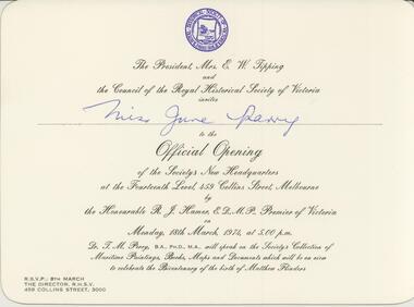
Document - INVITATION, 1974
... of Maritime Paintings, Books, Maps and Documents which will be on view... of Maritime Paintings, Books, Maps and Documents which will be on view ...Official invitation to Miss June Parry to official opening of the new headquarters for the Royal Historical Society. Large cream coloured card the the emblem of the Royal Historical Society printed in blue at the top. The following words are printed in black script: The President Mrs E W Tipping and the Council of the Royal Historical Society of Victoria invites Miss June Parry to the Official Opening of the Society's New Headquarters at the Fourteenth level 459 Collins Street Melbourne by the Honourable R J Hamer Premier of Victoria on Monday 18th March 1974 at 5:00pm. Dr T M Perry will speak on the Societys Collection of Maritime Paintings, Books, Maps and Documents which will be on view to celebrate the Bicentenary of the birth of Matthew Flinders.event, official -
Surrey Hills Historical Society Collection
Archive - Vertical file, Armitstead family
... A vertical file containing the following documents: 1. Land... the following documents: 1. Land Victoria map of Surrey Hills including ...The Armitstead family's first woodyard in Surrey Hills was located in Croydon Road but later they moved to 153-157 Union Road, Surrey Hills. The business delivered timber and briquettes for heating to homes in the local area but also blocks of ice in the days before refrigerators were a usual household appliance. The timber was unloaded from railway trucks at a siding at Surrey Hills station; some came from the Armitstead's property of 130 acres of timbered land near Killara. They also sold mallee roots and briquettes.A vertical file containing the following documents: 1. Land Victoria map of Surrey Hills including Union Road from Bedford Street to Montrose Street, showing location of woodyard (undated) (1 A3 page). 2. Possibly ‘Sun’ article ‘When Surrey Hills ran short of wood’, Michael Sefton (undated) (1 page). 3. Plaque for the red mechanism of the weighbridge at Centre, by convenor, Surrey Hills Heritage Group, 12.11.2002 (1 page). 4. Pooley and Sons weighbridge, notes by Dennis Armstrong, in email to Sue Barnett, 4.4.2013 (2 pages). 5. Laminated diagram and notes by Ken Hall re weighbridge from Armitstead’s woodyard, and photocopy, undated (3 pages). 6. ‘Armitstead’s woodyard’ 153-7 Union Road (now Neighbourhood Centre), typed Progress Leader article, 13.1.1982 (2 pages). pooley and sons weighbridge, armitstead family, woodyard, armitstead's woodyard, union road -
Glen Eira Historical Society
Article - OUTER CIRCLE RAILWAY
... Division. The document includes three maps of the outer circle... of a document titled THE OUTER CIRCLE RAILWAY by the Royal Historical ...This file contains five items: 1/Two copies of a document titled THE OUTER CIRCLE RAILWAY by the Royal Historical Society of Victoria and the Australian Railway Historical Society, Vic div. It details the history of the construction of the Outer Circle Railway and discussed expenses and other factors affecting the construction of the line. Notes compiled by R.K Whitehead, Research and Archives Officer Australian Railway Historical Society Victoria Division. The document includes three maps of the outer circle railway line. 2/Four newspaper articles detailing the history of the Outer Circle Railway Line. They include ten black and white images of various aspects of the railway and three line maps. The first article is titled ‘Rail Link with the Past’. In the COLLINGWOOD COURIER dated 07/10/1970, author unknown. The second article titled ‘Ghost trains of the Outer’ by Kenneth Joachim in the HERALD dated 18/04/1975. The third article is titled ‘Tracks in Time’ by Norman Thompson from NEWS, dated 13/02/1973. The fourth article is titled ‘Our Ghost Railway’ by John Townsley from the HERALD, dated 06/11/1974. 3/A letter from Victorian Railways Chief Estate Officer N.A Wigmore to the Honorary Secretary of the Caulfield Historical Society, dated 19/11/1975 regarding the leasing of land along the Outer Circle Railway Reserve from Dandenong Road to the Hughesdale Station. 4/Two copies of an article titled ‘Outer Circle Railway’ in the CAULFIELD HISTORICAL SOCIETY NEWSLETTER undated detailing the history of the outer circle line. The article includes a map of the section of the line in Caulfield. 5/A Photocopy of two images of train line locations on the Outer Circle Line. One on Warrigal Road, looking south from Ashburton dated 1936. The second is of the Black Bridge over Gardiners Creek dated 1935.outer circle railway, normanby road, caulfield station, outer circle line, rosstown junction railway, monash john, caulfield historical society, poath road, deepdene dasher, ashby dasher, dandenong road, gippsy goods, mallee root mercury, outer circle railway reserve, railway lines, railway stations, steam trains -
 Bendigo Historical Society Inc.
Document - MCCOLL, RANKIN AND STANISTREET COLLECTION: INDENTURE NORTH DEBORAH MINING COMPANY, 20th November, 1952
... Bendigo' plus map. Indenture document between Queen Elizabeth 11... Company No Liability. Map, fixed to document, heading ' Mining ...6 page document ' Gold Mining Lease Crown land Number 11307 Bendigo' plus map. Indenture document between Queen Elizabeth 11 and North Deborah Mining Company No Liability, Parish of Sandhurst, dated 20th November, 1952 re Vol 333, Folio 053. Land indicated by yellow on map and below ' a depth of one hundred and fifty feet from the surface of the land indicated by purple colour and delineated on the plan' Document signed by J. Stanistreet, Manager, North Deborah Mining Company No Liability. Map, fixed to document, heading ' Mining District of Bendigo, No. 11307, County of Bendigo, Parish of Sandhurst, Total area 13 acres 2 roods, 11 perches. Map shows large dam on Crown land, transmission line excised 150 ft., written on purple area. Underneath map ' provided that the dam indicated on the said plan is hereby reserved'.bendigo, mining, north deborah mining company -
Glen Eira Historical Society
Document - History of the City of Caulfield
... of Caulfield’. 8 pages, 2 copies. This document also includes a map... of Caulfield’. 8 pages, 2 copies. This document also includes a map ...This file contains 4 items: 1/Typewritten document titled ‘The City of Caulfield’. Author and date unknown. 1 page (back and front), 2 copies. Document covers topics such as origins of the name ‘Caulfield’, early settlement and the Caulfield Cup. 2/Typewritten document titled ‘History of Caulfield Council’. Author and date unknown. 6 pages, 3 copies. Document covers subjects such as early settlement, Aboriginal influence, Caulfield Road Board, Shire of Caulfield, Borough and town boundaries, coat of arms, and Freedom of Entry to the City. 3/Typewritten document (undated + author unknown) titled ‘The Structure of Local Government in Victoria with a history of the City of Caulfield’. 13 pages. Covers the following subjects: Powers, Planning, Public Works, Trading Undertakings, Health Services, Municipalities, Wards Electors or Ratepayers, Voters Roll, Councillors, Officers, Finance, Nature of Soil and Vegetation, Parks and Gardens and Reserves, Coat of Arms, Boundaries, How Did Caulfield get its Name, Aboriginal Influence, Caulfield Road Board, Shire of Caulfield, Borough and Town and the City of Caulfield. Also covered is early settlement. Note at the end of the document mentions that the historical content contained in the last section was based upon a thesis for the Department of Town and Regional Planning, University of Melbourne, 1968 by L. Alwis, P. Rowe, N. Wootten. Melbourne, ‘City of Caulfield: An Illustrated City Report’. 4/Typewritten document (undated) titled ‘The Structure of Local Government in Victoria with notes on the history of the City of Caulfield’. 8 pages, 2 copies. This document also includes a map/diagram of the city with boundaries and wards showing locations of railway stations and parks. Document covers the structure of local government and its functions then goes on to focus on City of Caulfield with subjects similar to those covered in item 3. Document signed off by Deputy Town Clerk.city of caulfield, caulfield john, caulfield baron, caulfield racecourse, elsternwick, ripponlea, st. mary’s church, caulfield council, kooyong road, neerim road, bambra road, greenmeadows house, caulfield park, paddy’s swamp, dandenong road, caulfield grammar school, chisholm institute of technology, murrumbeena, glen eira road, alma road, orrong road, balaclava road, inkerman road, ‘grosmont’, caulfield school room, caulfield road board, caulfield road district, crimean war, victorian amateur turf club, caulfield cup, glenhuntly road, north road, glenhuntly station, ormond station, outer circle railway, local government, gardenvale, carnegie, rosstown, poath road, nepean highway, hotham street, ormond park, princes park, ross william murray, caulfield institute of technology, ‘ross’ folly’, hawthorn road, glenhuntly, ormond, morris t. w., lloyd charles du plan, meals on wheels, shire of caulfield, caulfield railway station, caulfield rsl, bouran road, murrum murrumbeen, kooyong road, great dandenong road, neerim road, trams, prahran and malvern tramways trust, fisher andrew, mackinnon reserve, dover street, ‘glen eira’, blair max cr., insignia, third ordnance services unit, schools, street lighting, lampriere, mr. bevan, the caulfield leader, davies j. henry, curraweena road, st. georges road, o’neill college, hope george, market gardens, koornang reserve, packer reserve, murrumbeena reserve, hopetoun gardens, greenmeadows gardens, mirambeena, caulfield technical college, hart john, langdon h. j., ‘rosecraddock’, judge webb, ‘crotonhurst’, service james, ‘kilwinning’, ricketson henry, grimwade frederick sheppard, airdrie, jenner, st. aubin’s, caulfield john p. t., harlston, lempriere, lord reserve, ‘cantala’ -
 The Beechworth Burke Museum
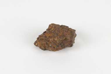
Geological specimen - Laterite
Laterite refers to both a rock and a soil type that is rich in clay, as well as Iron and Aluminium. It is created during a process that is called laterization, where high heat and seasonal heavy rainfall cause there to be wet and dry periods, which over time hardens the soil into rock. Because of this, most laterite is formed between tropics of Cancer and Capricorn. The iron oxide in laterite is what gives it it’s orange-red colouring. The largest religious complex in the world, Angkor Wat in Cambodia, is partially constructed of laterite, particularly its foundations, as laterite is porous and allows rainwater to drain. This specimen of laterite was collected from the Democratic Republic of Congo while it was colonised by Belgium in the 19th century. Laterite forms in many parts of the world, particularly between the tropics. It is used both for ore and as a building material, and comparing specimens from different parts of the world allows us to document the different compositions that this mineral can have when formed at different locations. This specimen is part of a larger collection of geological and mineral specimens collected from around Australia (and some parts of the world) and donated to the Burke Museum between 1868-1880. A large percentage of these specimens were collected in Victoria as part of the Geological Survey of Victoria that begun in 1852 (in response to the Gold Rush) to study and map the geology of Victoria. Collecting geological specimens was an important part of mapping and understanding the scientific makeup of the earth. Many of these specimens were sent to research and collecting organisations across Australia, including the Burke Museum, to educate and encourage further study.a palm-sized solid iron-aluminium oxide mineral specimen in shades of brown, orange and greyburke museum, beechworth, geological, geological specimen, laterite, laterite specimen, geology -
 Orbost & District Historical Society
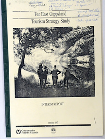
book / document, Far East Gippsland Tourism Strategy Oct 1987, October 1987
The project team for this document comprised E. Beacham, T. Claridge, B. Ebbs, C. Wilso. and J. Cristofaro.This booklet is a useful refernce tool.A document of 86 pp, titled Far East Gippsland Tourism Strategy Study Interim Report October 1987. it has a cream cover and black binding with a b/w photograph of four people in a bushland setting. It contains fold-out maps.tourism-east-gippsland -
 Orbost & District Historical Society
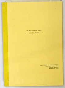
document, BALDWIN SPENCER TRAIL Project Brief 1988, February 1988
This document was produced by the Department of Conservation, Forests & Land Management, Orbost, to commemorate the visit by Baldwin-Spencer in 1989 as part of the Bicentennial Walking Tracks Project. The Baldwin Spencer Trail closely follows the route of scientist and explorer William Baldwin Spencer. Sir Walter Baldwin Spencer KCMG (23 June 1860 – 14 July 1929) was an English-Australian biologist and anthropologist. this booklet is a useful reference tool.A document of 10 pp with a cream cover, titled, Baldwin Spencer Trail Project Brief Feb 1988. It contains mapsbaldwin-spencer -
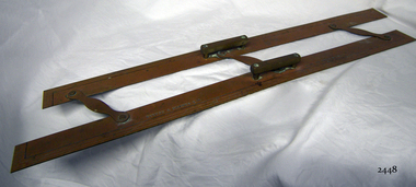 Flagstaff Hill Maritime Museum and Village
Parallel Rule, 1947-1955
History/Context: In 1947, the scientific instrument manufacturing firms of Henry Hughes & Son Ltd, London, England, and Kelvin Bottomley & Baird Ltd, Glasgow, Scotland, came together to form Kelvin & Hughes Ltd. Hughes Company History: Henry Hughes & Sons were founded in 1838 in London as a maker of chronographic and scientific instruments. The firm was incorporated as “Henry Hughes & Sons Ltd” in 1903. In 1923, the company produced its first recording echo sounder and in 1935 a controlling interest in the company was acquired by S Smith & Son Ltd resulting in the development and production of marine and aircraft instruments. Following the London office's destruction in the Blitz of 1941, a collaboration was entered into with Kelvin, Bottomley & Baird Ltd resulting in the establishing “Marine Instruments Ltd”. Following the formal amalgamation of Kelvin, Bottomley & Baird Ltd and Henry Hughes & Sons Ltd in 1947 to form Kelvin & Hughes Ltd. Marine Instruments Ltd then acted as regional agents in the UK for Kelvin & Hughes Ltd who were essentially now a part of Smith's Industries Ltd founded in 1944 and the successors of S. Smith & Son Ltd. Kelvin & Hughes Ltd went on to develop various marine radar and echo sounders supplying the Ministry of Transport, and later the Ministry of Defence. The firm was liquidated in 1966 but the name was continued as Kelvin Hughes, a division of the Smiths Group. In 2002, Kelvin Hughes continues to produce and develop marine instruments for commercial and military use. (See Note section this document for further information on the company's origins)This model parallel map ruler is a good example of the commercial diversity of navigational instruments made by Kelvin & Hughes after world war 2. It was made in numbers for use by shipping after the second world war and is not particularly rare or significant for its type. Also, it was made no earlier than 1947 as the firms of Kelvin, Bottomley & Baird Ltd and Henry Hughes & Sons Ltd who took over from Smith & Sons were not amalgamated until 1947. It can there for be assumed that this ruler was made during the company's transitional period to Kelvin & Hughes from Smith Industries Ltd.Metal parallel rule with Kelvin & Hughes Ltd, Made in Great Britain imprinted, numerous measurements, two handles and 3 hinges.flagstaff hill, warrnambool, shipwrecked-coast, flagstaff-hill, flagstaff-hill-maritime-museum, maritime-museum, shipwreck-coast, flagstaff-hill-maritime-village, parallel rule, kelbin & hughes ltd, metal parallel rule -
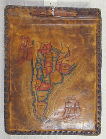 Mission to Seafarers Victoria
Album - Photographic album, Allan Charles Quinn
This photo album documents the voyage of Allan Quinn while he was in the merchant navy. The album and photos give a view of Quinn's trips around the world and the many places he visited. Leather-bound photo album. Cover is embossed with a colour map of South America.The cover contains the map of South America with a picture of a man with a pipe in his mouth in the top left-hand corner and a picture of a sailing ship in the bottom right. The inside front cover lists in handwritten columns: ports of call during 1947-48. There are three loose photos inside the front cover. album, photos, allan quinn, tourism, seafarers, sailors, seamen, ships -
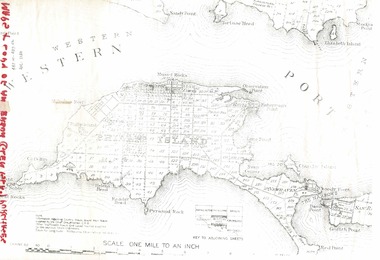 Phillip Island and District Historical Society Inc.
Document, 1869 Crown Land sale and map of Phillip Island showing allotments
Anderson and McHaffie were prominent early settlers of Phillip Island. These documents were from the estate of Stan Mcfee snr. Listings of auctions at Gemmell, Tuckett & Co., Collins Street, Melbourne 12 February, 1869HistoricalCopy of map showing allotments for 1869 land sale and hand written note showing allotments, area, prices for purchases of Robert Anderson and notes on McHaffie land.robert anderson, glen isla, john mchaffie, maps, land sales -
Ringwood and District Historical Society
Documents, City of Ringwood, Demographic profile of the City of Ringwood August 1989, 1960/1989/1991
During refurbishment of office in Civic Centre sent to VRDHS by Miranda de Giorgio, Community Liaison Officer 8-Dec-1993.Collection of documents about the City of Ringwood - civic centre.; 1. Demographic profile of the City of Ringwood August 1989.; 2. City of Ringwood - An Information Guide for Students- Nov 1991.; 3. Councillors names and addresses 5-Aug-1991; 4. Civic Centre - New Telephone Numbers; 5. City of Ringwood - Boundary Map; 6. City of Ringwood - 3 folders (2 coloured) 1960 +Additional Keywords: de Giorgio, Miranda -
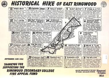 Ringwood and District Historical Society
Document, Historical Hike of East Ringwood -1993
Black and white laminated mapMap includes 20 separate locations of historical interest around East Ringwood. Produced for the Ringwood Secondary College Fire Appeal Fund -September 16th 1993 -
 Ringwood and District Historical Society
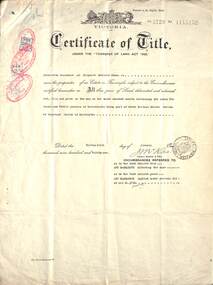
Document, Land Title Certificate for Henrietta Greenwood of Ringwood, Vic. - 31st January, 1931. (4 pages)
Certificate of Title - Henrietta Greenwood, Ringwood, Victoria, including Transfers and map of subdivisionIncludes transfers as part to Ernest Allan Devenish, 27th October, 1938 Lillian Alice Clegg, 10th July, 1936 Francis Leslie Little and Rose Little, 12 November, 1940 Ralph Wigley, 25 November, 1937 Alan Geoffrey Clegg, 25 November, 1937 Phillip McKinley, 8 May, 1941 John Andrew Pearson, 11 May, 1938 Paul Clegg, 8 May, 1941 The Mayor, Councillors and Burgsses of the Borough of Ringwood, 18 June, 1941 Ruby Grace Holloway, 15 October, 1941 William Herbert Holloway, 28 June, 1949 -
 Bendigo Military Museum
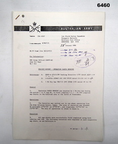
Administrative record - 1 Fd Svy Sqn Project Report - Operation Carto Mercury 1986, 28 Jan 1986
Operation Carto Mercury was a field completion Operation mounted by 1 Fd Svy Sqn 11 Aug 1985 to field complete 4 x 1:25000 compiled map sheet in the Cabarlah area to the North of Tawoomba. Included maps: 9243 - 23 Kingsthorpe, 9243 -24 Goombungee, 9243 - 21 Gomaren Creek, 9243 - 22 High FieldsA4 Typed document and diagrams, 14 pages. Report produced by 1 Fd Svy Sqn 1986royal australian survey corps, rasvy, fortuna, army survey regiment, army svy regt, asr, 1 fd svy sqn -
 Bendigo Military Museum
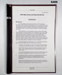
Administrative record - DIGO Map Library and Repromat Review 2004, Geospatial Analysis Centre, Bendigo, 25 Oct 2004
Prior to the digital revolution the only medium by which cartographic information could be reproduced and distributed on mass was via printed media. The final negatives (repromat) used to produce the printed products were the culmination of a complex cartographic process and were therefore carefully preserved and stored. Preservation of the so-called final negatives enabled subsequent reprinting with minimal cartographic intervention. Since the arrival of the Land Headquarters Cartographic Company at Fortuna in 1942 the repromat for all products produced by the Australian Survey Corps were carefully stored. With the disbandment of the Army Survey Regiment in 1996 the Defence Imagery and Geospatial Organisation (DIGO) inherited that repromat archive. It was immanent that the support for film based printing was ending so on 25 October 2004 a review was required to determine the way ahead for the repromat and paper maps stored in the DIGO Map Libraries. Most of these maps were produced by the Royal Australian Survey Corps. This report is the result of that review. The report recommends the disposal of the repromat and the retention of single map copies. A4 plastic covered report, plastic clip bound, front page clear and rear page red. 9 x page document about the future of repromat and map printing.royal australian survey corps, rasvy, fortuna, army survey regiment, army svy regt, asr -
 Bendigo Military Museum
Document - PNG PAPERS, HERDMAN, Ansett - ANA et al, 1964- 1969
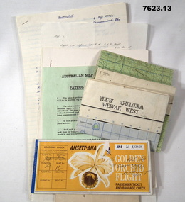
Collection of documents related to K.J. Herdman's visit to PNG as part of CMF Officer's visit, 2nd Dec to 13th Dec 1968. Part of the "Kevin John Herdman" No. 397661 Collection. See Catalogue No. 5942P for details of his service. 2. Notes related to Herdman's visit to PNG. List of personnel on visit. 4. Patrol ration pack details. 5. PNG Training Depot Hand Book, 6. Report - CMF Officer's visit to PNG. 2-13 Dec 1968. 8. Extended report by K.J. Herdman on CMF Officer's visit to PNG Command 1968. dated 21 Feb 1969. 9. Document related to CMF Officer's visit to Lae battlefields. 10. Detailed itinerary of CMF Officer's visit to Lae Battlefields. 11. Document detailing the organisation of PNG Command. 12. Document detailing the organisation of PNG Command. 12. Document detailing the organisation of HQ PNG Command (Murray Barracks) 13. Document detailing the itinerary for CMF Officers visit to PNG Command. the groups involved. K.J. Herdman was in Group 2. 1. Two (2) Rectangular paper airline tickets. Front page is orange in colour with black and white text. Picture of a flower. handwritten passenger details, handwritten flight details inside each, tickets stapled together. 2. Small cream coloured soft cover notebook. Title and Rising Sun logo on front in black. lined pages with cut edges. Pages secured with two staples. 3. Topographical map of New Guinea - Wewak West. 4. Green coloured single page pamphlet with text in black on both sides. one side in English and the other in Pidgin English. 5. Quarto sized nine page document. Front cover has title in black and a black line illustration featuring a palm tree and crocodile. Pages stapled together along spine. 6. Handwritten foolscap sized document. Text in black ink. Writing on one side. 7. Letter handwritten in blue ink. Writing on one side. plain paper. 8. Handwritten foolscap sized document. Text in blue ink. 8 pages of writing. Pages stapled in top LHC. 9. Foolscap sized document with text in black type. Printing on one side of each page. Two sheets of plain paper stapled on to LHC. 10. Three (3) page foolscap sized document with pages stapled on top LHC. Text in black type. Printing on one side of each page. 11. Five (5) page foolscap sized document with pages stapled on top LHC in landscape format. Text in black type, 12. Single page foolscap sized document with text in black type. 13. Eight (8) page foolscap sized document with pages stapled on top LHC. Text in black type.1. Handwritten passenger details on cover and inside each ticket. 2. Handwritten notes in blue ink on first 11 pages. 12. Handwritten on back of paper in black ink: THE DOCTOR SAID "YES", Brian Best.army, training notes, kevin john herdman -
 Bendigo Military Museum
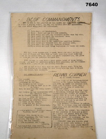
Document - BCOF COMMANDMENTS, C1945 - 1950
Item in the BCOF Association Collection, refer Cat No 7625This is a single page document printed both sides. It has been laminated. Side one - typed wording in black ink. Headlines are:- "BCOF COMMANDMENTS", "THE GENERAL'S PRAYER" and "REHAB CORNER" Side Two - A map showing Japan at the top, Australia at the bottom. It shows the course the ship HMAS MANOORA took to come home. Numbers along the way show 1800 hrs and the day/date at that time.japan, japan occupational forces, hmas manoora -
 Bendigo Military Museum
Print - PRINT, FRAMED, WW1, Reader's Digest (Australia) Pty Limited, 2015
From information Book - "Readers Digest'/ Gallipoli/ 25th April 1915 - 9th January 1916/ Centenary Commemorative Prints." Collection of 20 prints. Refer Cat No. 7300.Framed print. Print - colour print on paper. MAP ANZAC - map scale 1:10,000 elevations in feet. Depicts the line of Australian and New Zealand Front Trenches. Intended as a working document. Frame - Black plastic framing with glass front and MDF board backing with adhered black paper.Details below print - in black ink. "GERALD R. CAMPBELL Anzac: Map of Gallipoli Peninsula, 1916"framed accessories, prints, ww1, gallipoli, centenary