Showing 2496 items
matching gardens and parks
-
 Kew Historical Society Inc
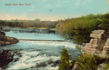
Postcard - Dight's Falls, River Yarra, c.1911
Dight’s Falls in Studley Park is an artificial weir built on a natural rock bar across the Yarra. The weir was built in the 1840s to provide water to the ‘Ceres’ flour-mill, one of the first in Victoria. The falls were later to become known as Dight’s Falls after the owners of the mill. Later, a pumping station was built on the Kew side of the river, which pumped water uphill to a reservoir in Walmer Street that provided water to the Melbourne Botanical Gardens and to Albert Park Lake. The area around Dight’s Falls was and is frequently used for recreational activities.Dated postcard allowing one to analyse the form of the Falls in 1911Colour postcard, of Dight's Falls on the River Yarra between Kew and Fairfield. The photograph is taken looking upstream towards the Falls from the Kew side, from the embankment in the vicinity of the Pumping Station. Obverse: "Dight's falls, Kew" Reverse: "Printed in Great Britain Writing in ink on Reverse: "31/3/1911 / To dear Nell with best wishes for a happy birthday from your old friend Eve / [Addressed to] "Mrs N Dunn, Prahran" Franked Victorian 1d stamp on Reverse top rightdight's falls, dight's falls - kew (vic) - fairfield (vic) -
 Kew Historical Society Inc
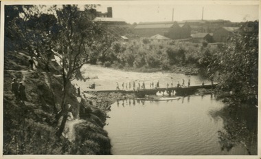
Photograph - Crossing Dights' Falls on the Yarra by foot
Dight’s Falls in Studley Park is an artificial weir built on a natural rock bar across the Yarra. The weir was built in the 1840s to provide water to the ‘Ceres’ flour-mill, one of the first in Victoria. The falls were later to become known as Dight’s Falls after the owners of the mill. Later, a pumping station was built on the Kew side of the river, which pumped water uphill to a reservoir in Walmer Street that provided water to the Melbourne Botanical Gardens and to Albert Park Lake. The area around Dight’s Falls was and is frequently used for recreational activities.Rare original print photograph of people walking across Dight's Falls when the river flow was low. View west towards Abbotsford. Photograph taken from Kew side of river above the Falls.Reverse: "M Holmes"dight's falls, river yarra -- kew - abbotsford -
 Kew Historical Society Inc
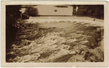
Photograph - Dight's Falls, 1920s
Dight’s Falls in Studley Park is an artificial weir built on a natural rock bar across the Yarra. The weir was built in the 1840s to provide water to the ‘Ceres’ flour-mill, one of the first in Victoria. The falls were later to become known as Dight’s Falls after the owners of the mill. Later, a pumping station was built on the Kew side of the river, which pumped water uphill to a reservoir in Walmer Street that provided water to the Melbourne Botanical Gardens and to Albert Park Lake. The area around Dight’s Falls was and is frequently used for recreational activities.One of a series of photographs, probably taken by Henry Christian of the Yarra River in Kew. An item from an outstanding and diverse photographic collection, assembled by members of the Christian and Washfold families of Kew.River Yarra at Dight’s Falls, Kew/Fairfield photographed from Kew bank.dight's falls, river yarra, christian-washfold collection -
 Kew Historical Society Inc
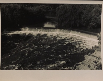
Photograph - The Race at Dight's Falls, 1925
Dight’s Falls in Studley Park is an artificial weir built on a natural rock bar across the Yarra. The weir was built in the 1840s to provide water to the ‘Ceres’ flour-mill, one of the first in Victoria. The falls were later to become known as Dight’s Falls after the owners of the mill. Later, a pumping station was built on the Kew side of the river, which pumped water uphill to a reservoir in Walmer Street that provided water to the Melbourne Botanical Gardens and to Albert Park Lake. The area around Dight’s Falls was and is frequently used for recreational activities.Original, black and white positive of water flowing over the 'Race' at Dight's Falls in MelbourneInscribed verso: "The Race at Dight's Falls / River Yarra Melbourne / 1.3.25" "Kodak Print"dight's falls, river yarra, yarra -- kew (vic.) -
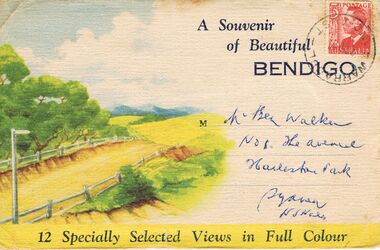 Bendigo Historical Society Inc.
Postcard - A SOUVENIR OF BEAUTIFUL BENDIGO 12 SELECTED VIEWS IN FULL COLOUR
A Booklet of 12 views of Bendigo posted to NSW . A 3d stamp of King george VI. Photo 1 Entering Bendigo from the North. - Photo 2 Overlooking a Section of Bendigo - Photo 3 Baths and Park Bendigo - Photo 4 Garden and Post Office Bendigo - Photo 5 A Typical Mining Scene - Photo 6 Rosalind Park - Photo 7 Pall Mall - Photo 8 Law Courts and Conservatory - Photo 9 One of Bendigo Many fine Churches - Photo 10 Overlooking Portion of Bendigo - Photo 11 Charing Cross and Pall Mall - Photo 12 Section of Conservatorypostcard, photograph, bendigo -
 Eltham District Historical Society Inc
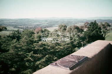
Slide, Shire of Eltham War Memorial Tower, Eltham-Yarra Glen Road, Kangaroo Ground, 24 Jul 1973
Various views from each side of the tower lookout. The Memorial Park and Shire of Eltham War Memorial tower are sited at was once known as Garden Hill and was reknowned for its panoramic views it offered tourists from the 1880s on. It was claimed that the full extent of the former Shire of Eltham could be looked upon from this viewpoint - and extending beyond.35 mm colour positive transparency x 7 Mount - Agfacolor Service (Blue)kangaroo ground, shire of eltham, war memorial tower, eltham-yarra glen road, shire of eltham war memorial -
 Bendigo Historical Society Inc.
Document - Letter to Allan Llewellyn, Eaglehawk, from the Mitchell Library, Sydney - reply concerning Henry Lawson 'Bob Brothers' and 'Send Round the Hat', 1957
At the lookout in Rosalind Park Bendigo. The sundial and garden court are erected as a memorial and tribute to Bob Brothers, a native of this City of Bendigo. His charity, kindness and comradeship, particularly at Bourke on the Darling River NSW, inspired Henry Lawson to characterise him in the story `Send around the Hat`. `And I wish that I could immortalise him`. Henry LawsonLetter to Allan Llewellyn, Eaglehawk, from the Mitchell Library, Sydney - reply concerning Henry Lawson 'Bob Brothers Memorial in Rosalind Park Bendigo' and 'Send Round the Hat'. Photocopy of Alan's research.history, bendigo, eaglehawk, henry lawson, bob brothers, send round the hat, bendigo rosalind park, allan llewellyn collection -
 Melbourne Legacy
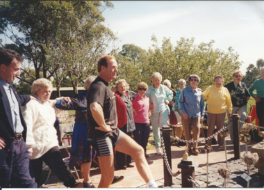
Photograph, Widows activities, 1995
Photograph of an outing for Legacy widows, with an instructor demonstrating gentle exercises in a garden. It was published in the June 1995 edition of The Answer with the details: "Preston/Reservoir Legacy Widows' Club. Members enjoyed a session of gentle exercise, a healthy meal and a beautiful day - all that was needed for a wonderful event at Bundoora Park last month. Sponsored by Veterans Promotions Department."A record of one of the many activities arranged by the Widows Clubs.Colour photo of a widows' outing in 1995.widows, exercise classes, activities, answer -
 Mission to Seafarers Victoria
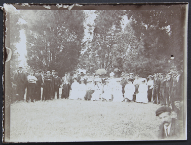
Photograph - Photograph, Sepia, Mr and Mrs Gurney Goldsmith, New Year's Day at the Zoo, 1907, 1 January1907
... gardens ...Seafarers and LHLG members photographed during their zoo outing on New year's day, 1907Small monochrome outdoor photograph, depicting a large gathering of men and women grouped in a rough semi-circle, quite formally dressed, posing to be photographedzoo, 1907, mr dudley le souef, picnic, lhlg, ladies harbour lights guild, sailors, seamen, seafarers, gardens, parks, new year, umbrella -
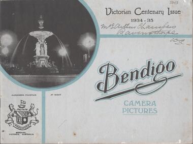 Bendigo Historical Society Inc.
Book - BENDIGO CAMERA PICTURES VICTORIAN CENTENARY ISSUE 1934-1935
Soft cover booklet entitled ' Bendigo, Camera Pictures - Victorian Centenary Issue 1934-1935'. 20 pages of B&W photos of Bendigo's buildings, parks and gardens, statues etc. Text by B. Mundy. Illustrates the progress of the City of Bendigo from 1857 to 1934. Produced and published by The Campbell Press and Bolton Bros, Bendigo. Handwritten on front cover 'Mrs Arthur Chambers, Ravensthorpe, WACampbell Press, Bolton Bros, B.Mundy -
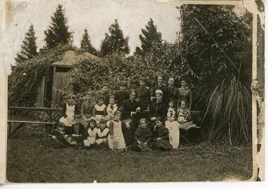 Ruyton Girls' School
Photograph - Group photograph, Mrs Charlotte Anderson with younger students, Original image: 1885 circa
In 1878, Mrs Charlotte Anderson founded an private school for girls in her home at Bulleen Road, Kew (now 63 High Street South, Kew). She moved her school to ‘Edgecomb’, in Studley Park Road in 1882 and named it Ruyton. Charlotte Anderson retired in 1888, and sold her school to Miss Eliza Bromby. This image was used to illustrate The Ruytonian, June 1915, p2. The date of manufacture of the duplicate photograph is unknown.Black & white duplicate photograph of Mrs Charlotte Anderson with staff and a group of younger students from Ruyton Girls’ School, c.1885. The group is arranged in three rows of seated and standing individuals, and is located on a garden setting. The photograph was taken at ‘Edgecomb’, Studley Park Road, Kew which was the location of Ruyton from 1882-1888. Mrs Anderson is seated in the middle row, third from right. ruyton girls' school, kew, charlotte anderson -
 Kew Historical Society Inc
Photograph, J F C Farquhar, Studley Park Road, 1891
At the beginning of the 1890s, the Kew businessman and Town Councillor, Henry Kellett, commissioned J.F.C. Farquhar to photograph scenes of Kew. These scenes included panoramas as well as pastoral scenes. The resulting set of twelve photographs was assembled in an album, Kew Where We Live, from which customers could select images for purchase.The preamble to the album describes that the photographs used the ‘argentic bromide’ process, now more commonly known as the gelatine silver process. This form of dry plate photography allowed for the negatives to be kept for weeks before processing, hence its value in landscape photography. The resulting images were considered to be finely grained and everlasting. Evidence of the success of Henry Kellett’s venture can be seen today, in that some of the photographs are held in national collections.It is believed that the Kew Historical Society’s copy of the Kellett album is unique and that the photographs in the book were the first copies taken from the original plates. It is the first and most important series of images produced about Kew. The individual images have proved essential in identifying buildings and places of heritage value in the district.In this view of Studley Park Road, looking northeast to the Junction, the photographer invites the viewer to participate in a point-of-view that emphasises the elevated, tranquil vantage point of the hill in contrast to the bustling commercial area in the distance. The view emphasises the exclusiveness of Studley Park, with its high fences behind which a number of significant Kew mansions were concealed. Contemporary advertisements for the sale of mansions in Studley Park Road often included fulsome descriptions of their elaborate formal gardens, as well as paddocks for grazing, stabling and dairies. None can be seen here. The use of high, protective wooden pickets to surround the newly planted avenue of elms on the south side of the road appears to be typical of the period. Similar examples can be seen in early photographs of Wellington and Princess Streets.The horse and carriage, selected as a central focus of the view, reinforces the residential, exclusive nature of this part of Kew in the early 1890s. Studley Park Roadkew illustrated, kew where we live, photographic books, henry kellett -
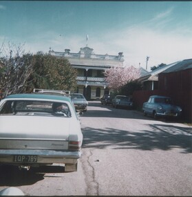 Rutherglen Historical Society
Images, 1970s
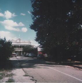
One of a collection of photographs from the Iggsten Estate. Post Office lane ran from Main Street to Reid Street, and much of it is now the car park for the IGA Supermarket. The Main Street end between the supermarket and the post office is closed to all but pedestrian traffic, and is now called Gollings Square. It is a rest area with trees, garden, sculptures and benches. Colour photograph showing the Victoria Hotel from the vantage point of Post Office Lane.victoria hotel, post office lane, florence iggsten, gollings square -
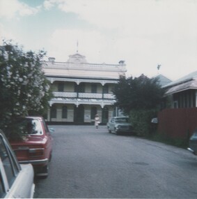 Rutherglen Historical Society
Images, 1970s
One of a collection of photographs from the Iggsten Estate. Post Office lane ran from Main Street to Reid Street, and much of it is now the car park for the IGA Supermarket. The Main Street end between the supermarket and the post office is closed to all but pedestrian traffic, and is now called Gollings Square. It is a rest area with trees, garden, sculptures and benches.Colour photograph taken in Post Office Lane, Rutherglen. The front of the Victoria Hotel is visible at the end of the road.post office lane, post offices, victoria hotel, florence iggsten, gollings square -
 Rutherglen Historical Society
Images, 1970s
One of a collection of photographs from the Iggsten Estate. Post Office lane ran from Main Street to Reid Street, and much of it is now the car park for the IGA Supermarket. The Main Street end between the supermarket and the post office is closed to all but pedestrian traffic, and is now called Gollings Square. It is a rest area with trees, garden, sculptures and benches. Colour photograph showing the Victoria Hotel from the vantage point of Post Office Lane.victoria hotel, post office lane, florence iggsten, gollings square -
 Kew Historical Society Inc
Photograph, J F C Farquhar, Dight's Falls, 1891
At the beginning of the 1890s, the Kew businessman and Town Councillor, Henry Kellett, commissioned J.F.C. Farquhar to photograph scenes of Kew. These scenes included panoramas as well as pastoral scenes. The resulting set of twelve photographs was assembled in an album, Kew Where We Live, from which customers could select images for purchase.The preamble to the album describes that the photographs used the ‘argentic bromide’ process, now more commonly known as the gelatine silver process. This form of dry plate photography allowed for the negatives to be kept for weeks before processing, hence its value in landscape photography. The resulting images were considered to be finely grained and everlasting. Evidence of the success of Henry Kellett’s venture can be seen today, in that some of the photographs are held in national collections.It is believed that the Kew Historical Society’s copy of the Kellett album is unique and that the photographs in the book were the first copies taken from the original plates. It is the first and most important series of images produced about Kew. The individual images have proved essential in identifying buildings and places of heritage value in the district.Dight’s Falls in Studley Park is an artificial weir built on a natural rock bar across the Yarra. The weir was built in the 1840s to provide water to the ‘Ceres’ flour mill, one of the earliest industrial sites in Melbourne. The falls were later to be named after the owner of this mill. In 1888, William Guilfoyle, Director of the Melbourne Botanical Gardens had called for fresh water to be piped from above the weir to the Botanical Gardens, using a pumping station on the Kew side of the Falls, a holding reservoir in Walmer Street and a series of pipes from there to the Gardens. This system was opened in May 1891. Farquhar’s photograph of the man-made weir obscures the industrial activity on both sides of the Falls and focusses solely on the river and the surrounding natural vegetation. The photograph probably predates the disastrous flooding of the Yarra River in July 1891, the greatest to have occurred in the Colony since the foundation of Melbourne.Dight's Fallskew illustrated, kew where we live, photographic books, henry kellett, yarra river -
 Melbourne Water
Staff Newsletter, Denine Moloney, First Female Apprentice Gardener, 1979
As the Yarra became unsuitable as a source of water, several attempts were made to find alternative sources for the growing population of Melbourne. It was not until 1891 that the efforts to sewer Melbourne came to fruition with the setting up of the Melbourne Metropolitan Board of Works (MMBW), now known as Melbourne Water. From 1891 until 1992, it was the responsibility of the MMBW to safeguard public health by providing a sewerage system and a safe water supply system. In 1992, The MMBW merged with a number of smaller urban water authorities to form Melbourne Water. Denine Moloney made history at the MMBW as the Board’s first female apprentice gardener, at the young age of 16. Denine was part of a team that cultivated and distributed up to 140,000 plants a year from the nursery complex that was housed on Warrigal Road, in Moorabbin. The large trees, shrubs and various other plants were all used in Board beautification projects. At the time, Denine lived with her parents and rode her bicycle to and from work each day while she attended Oakleigh Technical College one day a week as part of her apprenticeship. Denine’s ambition was to become a professional landscape gardener after her apprenticeship was completed, and four years later was in fact appointed as head gardener at Jells Park in 1983. Denine was not the last woman to work as a gardener at the Board, bringing with her two female assistants at Jells Park in caring, maintaining and distributing the Board’s horticulture. This staff newsletter highlights the significant achievement of Denine Moloney, becoming the first female gardener to work at the Board. This captured achievement highlights women's career advancement at the MMBW and within the Victorian public service, whilst having historic and social associations with the many women's rights movements of the 1970s.gardener, woman, melbourne metropolitan board of works, mmbw, staff, newsletter, 1970s -
 Eltham District Historical Society Inc
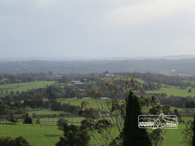
Photograph, View of Kangaroo Ground, 10 August 2016
View of Kangaroo Ground from the Moor rul Viewing Platform. As part of a program to acknowledge the Anzac Centenary Nillumbik Shire Council partnered with Yarra Plenty Regional Library to provide a bus tour with commentary of local sites of significance. These included Eltham township, the Shire of Eltham War Memorial at Kangaroo Ground, Christmas Hills war memorial, Hurstbridge memorial recreation park and finshed at Eltham Library to view the Writing the War exhibtion at Eltham Library Community Gallery. View of Melbourne from the Moor-rul viewing platform at War memorial park Kangaroo Ground, Garden Hill. Born Digitalwar memorials, shire of nillumbik, kangaroo ground, view, skyline, melbourne, moor-rul viewing platform, garden hill -
 Ballarat Tramway Museum
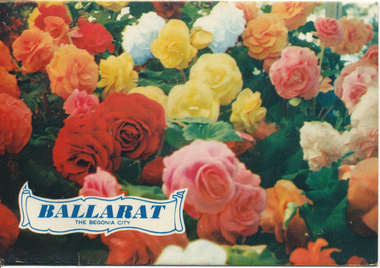
Postcard - Folder set, Nu-color-vue or Nucolorvue Productions, "Ballarat The Begonia City"
... Gardens ...Published by Nucolorvue Productions, Mentone, Victoria. Inside the folder is a printed note on Ballarat, with a note that it was just embarking on its second century, and has a population of 40,000 people. Printed c1955. Inside the folder was a two sided strip of 12 photos, that was glued to the folder. Features photos of the Botanic Gardens, Eureka stockade, floral clock in Sturt St, a view from the Town Hall with a tram parked in the City Loop, Civic Hall, the crown at Shell House, Sturt St at Lydiard St with a tram parked at the City centre and the Arch of Victory. See item 9120 for another similar production.Demonstrates a postcard folder produced by Nucolorvue.Printed colour postcard folder titled "Ballarat The Begonia City", featuring a photo of begonias on the cover and an address box on the rear of the folder. trams, tramways, sturt st, postcards, gardens, lake wendouree, begonia -
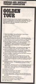 Bendigo Historical Society Inc.
Document - BENDIGO AND DISTRICT WALKING TOURS - THREE BROCHURES
Three walking tours ogf Bendigo Produced by Bendigo and District Tourist Association a Golden Tour - a two hour tour takes in a cross section of Bendigo's development from a booming gold field to a thriving provincial city (Fortuna to White Hills botanic gardens) b Blue Tour - an extension to the Golden Tour to include the mining areas of Eaglehawk c Walking tour - a leisurely stroll around the perimeter of Rosiland ParkBendigo and District Tourist Association -
 Ballarat Tramway Museum
Photograph - Black & White Photograph/s, Geoff Grant, 19/06/1955 12:00:00 AM
Black & White photo of M&MTB trams 988 and 1003 in Nicholson St, south of Albert St. intersection, testing overhead prior to opening of Bourke St. on 19/6/1955. Were the first and second trams on the line. Bus on right side of photo. Trees and park in background. Parliament Gardens out of view on right side. Negative scanned hi res and imaged updated 22/5/2020.On rear of photo in typed paper "988 stands while 1003 passes it on the Bourke St. route before any cars had started operating on this newly completed line. These cars were first and second cars to run over the line. 19 June 1955 Geoff Grant Photo." and "Geoff Grant" stamp in btm rh corner.trams, tramways, melbourne, bourke st, commissioning , tram 988, tram 1003 -
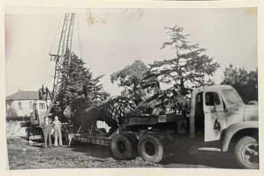 Kew Historical Society Inc
Photograph - Loading a palm tree from Tara Hall, Studley Park Road, c. 1960
Tom Bentley (1912-1993) was born in Lancashire (UK). From circa 1951, he was the Overseer/Superintendent of Outdoor Works for Kew City Council. Until his retirement in the 1970s, he was based at the Kew Council Depot, located in the former MTB Horse Tram Depot on the corner of Disraeli and High Streets, Kew. Accompanying the set of twelve photographs is a 12-page illustrated biography of the Bentley and Plumridge families, separately kept in the 'Bentley' subject file.Duplicate black and white positive print photograph of public works in Studley Park Road, Kew, carried out under the supervision of Tom Bentley, Overseer/Superintendent of Outdoor Works for the City of Kew. The location at which the photograph was taken is believed, by the donor, to be in the vicinity of Tara Hall (dem. 1960). The palm tree on the back of the Council vehicle was believed to have been taken by Council from Tara Hall and relocated to the Alexandra Gardens.city of kew, public works, studley park road, tom bentley, tara hall -
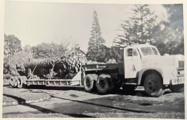 Kew Historical Society Inc
Photograph - Transporting a palm tree from Tara Hall, Studley Park Road, c. 1960
Tom Bentley (1912-1993) was born in Lancashire (UK). From circa 1951, he was the Overseer/Superintendent of Outdoor Works for Kew City Council. Until his retirement in the 1970s, he was based at the Kew Council Depot, located in the former MTB Horse Tram Depot on the corner of Disraeli and High Streets, Kew. Accompanying the set of twelve photographs is a 12-page illustrated biography of the Bentley and Plumridge families, separately kept in the 'Bentley' subject file.Duplicate black and white positive print photograph of public works in Studley Park Road, Kew, carried out under the supervision of Tom Bentley, Overseer/Superintendent of Outdoor Works for the City of Kew. The location at which the photograph was taken is believed, by the donor, to be in the vicinity of Tara Hall (dem. 1960). The palm tree on the back of the Council vehicle was believed to have been taken by Council from Tara Hall and relocated to the Alexandra Gardens.city of kew, public works, studley park road, tom bentley, tara hall -
 Bendigo Historical Society Inc.
Slide - Images by Arthur Pulfer, 1957-1970
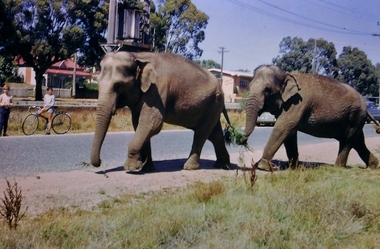
ROSEVIEW 407 High Street, Golden Square Bendigo "Roseview" was designed by Godfrey Eathorne and constructed in 1939. It is one of the few Streamline Moderne houses in the Central Goldfields region, and was one of the earliest constructed in the Bendigo region. It is an outstanding example of this style of housing. It resembles an ocean liner, and reflects the emphasis on the streamlining of methods of transportation. It utilizes both flat and curved surfaces and has little external ornamentation. The use of materials such as rounded glass windows and metal window and door frames reflects an innovative approach to construction consistent with the style. "Roseview" was constructed on a large scale, with large and spacious rooms. It reflects the prominent social status and wealth of the original owner, together with the desire for a building in 'the latest' style which was sure to attract attention and prominence in the region. It has been maintained largely in original condition. CARALULUP HOTEL 'The Sun' dated January 17, 1941 on the back. It states that 'The licence of Caralulup Hotel, near Talbot, has been surrendered, thus severing an 80 year association with the district' State Library of Victoria TOLMER GOLD ESCORT ROUTE The gold rush in New South Wales and Victoria left few able miners in South Australia. Bad economic conditions saw more than 15,000 men leave the Kapunda and Burra mines by the end of 1851. Alexander Tolmer, Commissioner of Police in 1852 proposed that the gold won by South Australians should be brought back to South Australia under an escort consisting of only a few men. In March a Gold Escort was on its way back to Adelaide with almost 6,000 ounces of gold for the vaults of the Treasury Building. After this successful trip Tolmer led two other escorts before handing over his duties. A total of eighteen gold escorts were made, the last one during November and December 1853 when Inspector Wyndham was in charge. You’ll find Gold Escort Route Monuments between Meningie, Coonalpyn and Tintinara.Many images from by Arthur Pulfer copied to slides. Twenty Slides of Bendigo: Bullen's Circus Bendigo February 1966 "Roseview", Pethard's Home at 407 High Street, Golden Square, Bendigo. 25th March 1957. House is possibly on the Midland Highway Epsom, Bendigo - 8 April 1955 Kangaroo Flat Bus Lines mini bus The Big Tree Sedgwick Road March 1972 The old Golden Gully Hotel Diamond Hill Road, Bendigo The old Lockup Eaglehawk Bendigo September 1967 Market Gardens - possibly North Bendigo North Deborah Mine photo taken from Breen Street 1958 Laying the track to get the engine into the park, looking down Mitchell Street Bendigo Engine R766 in the Victorian Railways Institute Park Railway Place Bendigo On the Methodist Church Steps Arnold street Bendigo Miner's Hut at Moliagul Basket Lunch - White Hills Botanical Gardens - St johns 100 year celebrations White Hills Swimming Pool February 1970 White Hills Botanical Gardens Bendigo Bendigo Show Parade 1958 The Arrival of the Cobb and Co Coach in Bendigo September 1963 history, bendigo, james lerk collection, golden square high school, dragon loong, white hill botanical gardens, 407 high street bendigo, r766 engine, bullens circus, caralulup, moligual, bendigo show, tolmer's gold route, kangaroo flat bus lines, eaglehawk lockup, arnold street methodist church, elephants -
 Eltham District Historical Society Inc
Document, Prospectus: Kinloch Gardens, Eltham Victoria, 1998c
... Prospectus: Kinloch Gardens, Eltham Victoria ...“Kinloch Gardens at Eltham, Victoria is planned as a comprehensively designed and cohesive residential environment.” “Only twelve innovatively designed houses ,will be situated within the established gardens and grounds of this historic Eltham estate. Building design and development will be under the control of the Kinloch Gardens design and construction team.” “Kinloch Gardens is situated on one of the highest points in Eltham and enjoys panoramic views in all directions.” “Kinloch Gardens lies hidden from the outside world behind high stone retaining walls, terraced embankments and extensive landscaping. The existing buildings, amongst the most significant of the Eltham / Montsalvat domestic building tradition are set in park like surrounds and enjoy panoramic views of the ranges to the north east and the city sky line to the west. New houses combined with sensitive landscaping will blend immediately into the established garden environment and will share the amenity and ambience of a very private and unique estate. The central theme of the landscape master plan is a garden reserve and a planted avenue terminating in a -small square.” “Houses vary in size from 120m2 (12.9 squares) to 210m2 (22.6 squares) (or larger) and include an extensive range of planning options. House types include: The Studio House The Tower House The Pergola House The Gallery House 'The Barn' is one of the existing buildings of Kinloch Gardens and is situated on the premium Lot 11.” Developer: Kinloch Pty Ltd. Project Managers: Creative Block Design Pty Ltd. Architects: Graeme Gunn and Ian Jelbart. Landscape Architect: Suzy Boyd. Builder: Vizarje Homes Pty Ltd. Surveyors and Engineers: Miller Merrigan.Digital file only; created from scan undertaken by EDHSarthur street, creative block design pty ltd., eltham, graeme gunn, houses, ian jelbart, kinloch gardens, kinloch pty ltd, miller merrigan, real estate, suzy boyd, vizarje homes pty ltd. -
 Eltham District Historical Society Inc
Document, Kinloch Gardens Property Album; Elders Real Estate sales material, 1998
... Kinloch Gardens Property Album; Elders Real Estate sales ...“Kinloch Gardens at Eltham, Victoria is planned as a comprehensively designed and cohesive residential environment.” “Only twelve innovatively designed houses ,will be situated within the established gardens and grounds of this historic Eltham estate. Building design and development will be under the control of the Kinloch Gardens design and construction team.” “Kinloch Gardens is situated on one of the highest points in Eltham and enjoys panoramic views in all directions.” “Kinloch Gardens lies hidden from the outside world behind high stone retaining walls, terraced embankments and extensive landscaping. The existing buildings, amongst the most significant of the Eltham / Montsalvat domestic building tradition are set in park like surrounds and enjoy panoramic views of the ranges to the north east and the city sky line to the west. New houses combined with sensitive landscaping will blend immediately into the established garden environment and will share the amenity and ambience of a very private and unique estate. The central theme of the landscape master plan is a garden reserve and a planted avenue terminating in a -small square.” “Houses vary in size from 120m2 (12.9 squares) to 210m2 (22.6 squares) (or larger) and include an extensive range of planning options. House types include: The Studio House The Tower House The Pergola House The Gallery House 'The Barn' is one of the existing buildings of Kinloch Gardens and is situated on the premium Lot 11.” Developer: Kinloch Pty Ltd. Project Managers: Creative Block Design Pty Ltd. Architects: Graeme Gunn and Ian Jelbart. Landscape Architect: Suzy Boyd. Builder: Vizarje Homes Pty Ltd. Surveyors and Engineers: Miller Merrigan.Digital file only; created from scan undertaken by EDHSarthur street, elders real estate, eltham, kinloch gardens, real estate agent, the barn -
 Glen Eira Historical Society
Article - Boyd Park
... Parks ...This file contains two items. Two original photographs of Boyd Park, date unknown. An article from the CAULFIELD/ PORT PHILLIP LEADER on a massive swamp gum tree that was felled by heavy winds in Boyd Park, Murrumbeena, dated 03/08/2012.glen eira, glen eira environment group, smith colin, caine paul, boyd park, murrumbeena, parks, conservation of natural land and energy economics, reserves, bushland, gardens, resources, trees, plants -
Glen Eira Historical Society
Document - Lempriere Avenue, 10, St. Kilda East
A brief history of the property at 10 Lempriere Avenue, St. Kilda East, built on a subdivision of the land of William George Lempriere. Includes some information on the Lempriere Family and public park, Greenmeadows Gardens. The document by Rosalind Landells, David Bick and Hilary Bullock of the Brighton Historical Society is dated October 30, 1995. Includes handwritten notes covering mostly same information. Includes bibliography.greenmeadows, lempriere william george, clarke william senior, lempriere john thomson, zimmerman a.k., nelson frank l., greenmeadows gardens, lempriere avenue, nelson m.d., st. kilda east, parks and reserves, zucker a.a., greenmeadows lane, lempriere family, lempriere’s paddock, councillors -
 Rutherglen Historical Society
Images, 1970s
One of a collection of photographs from the Iggsten Estate. Woman in photo may be Florence Iggsten. Post Office lane ran from Main Street to Reid Street, and much of it is now the car park for the IGA Supermarket. The Main Street end between the supermarket and the post office is closed to all but pedestrian traffic, and is now called Gollings Square. It is a rest area with trees, garden, sculptures and benches.Colour photograph taken in Post Office Lane, Rutherglen. Roof of the Post Office is visible on the left, and the front of the Victoria Hotel at the end of the road.post office lane, post offices, victoria hotel, florence iggsten, gollings square -
 Bendigo Historical Society Inc.
Newspaper - JENNY FOLEY COLLECTION: SNIPPETS OF BENDIGO HISTORY
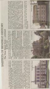
Bendigo Weekly from Friday November 2, 2001. Snippets of Bendigo History - The View Street Story - continued by Edith Lunn. This article describes two small buildings between the Queens Victoria garden and the entrance to Rosalind Parks and the Baby Health Centre . The article continues with a description of the more architecturally classical building on this side of View Street, The National Australia Bank building, the Sandhurst Club and the Sandhurst Trustees building. The clip is in a folder.newspaper, bendigo, bendigo weekly