Showing 1088 items matching "geological"
-
 Federation University Historical Collection
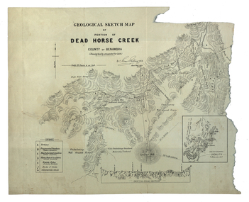
Map, Dead Horse Creek, 1887, 29/05/1887
Geological sketch map of a portion of Dead Horse Creek. WGS 84 Centroid Lat: 36 degrees 50 inches S Long: 148 degrees 00 inches S NS: 4.3km EW 4.8kmdead horse creek, james stirling, gold, geology, mount cobberas -
 Bendigo Historical Society Inc.
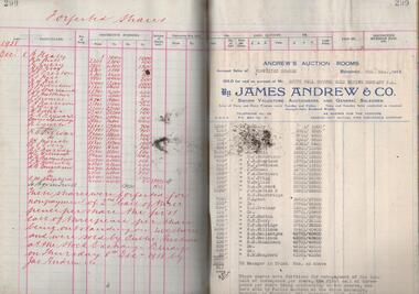
Administrative record - South Nell Gwynne G.M. Co. N.L. Share Register, 1939 to 1941
See Geological Survey Victoria: GSV Reference ID: 43711 South Nell Gwynne 'The Central Nell Gwynne which recently took over the reef prospected by Nell Gwynne ( B.M.L.) will continue to work the mine until the new Company, South Nell Gwynne Gold Mining Company is ready to take over. The main development work is at the 1080 feet level where stoping is being carried out on a spur system which has shown several colours of gold. ...The trial crushing in shaft sinking gave 4 dwt per gold per ton..... ' ( 29th July 1938, 'The Herald, Melbourne) 1941 Geological Survey Vic: SOUTH NELL GWYNNE, BENDIGO. MINING AND GEOLOGICAL JOURNAL: ' Journal, dark green hard cover, buff bindings on spine and corners. On spine of book in gold print: ' Share Register South Nell Gwynne G.M. Co. N.L.' South Nell Gwynne Gold Mining Company share register, 1938 to 1941. Alphabetical index in front, four hundred pages. Entries detail date of purchase, name of shareholder, distinctive number range, call account and paid by. Page 299 has a list of forfeited shares in the Company with a list of shares sold by James Andrew & Co., on 8th December 1938. Shares were 'forfeited for non payment of the 2nd call of threepence per share'. Share register is part of the Margaret Roberts Collection. bendigo, goldmining, goldfield, south nell gwynne gold mining co., nell gwynne, margaret roberts collection, mr j.j. stanistreet, mine manager -
 Federation University Historical Collection
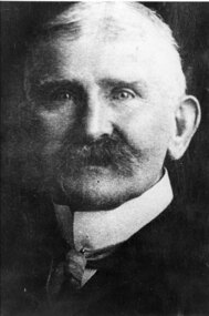
Photograph - Photograph (black & white), Ferdinand Moritz Krause
Civil engineer and geologist Ferdinand Moritz Krause lecturered at the Ballarat School of Mines from 1880 to 1895. He was born at Kassel, Germany on 24 February 1841, the youngest son of Frederich Wilhelm Krause. Ferdinand Krause married Amy Augusta Dimock. He died in South Africa 16 June 1918. In June 1880 Krausé was appointed to the Ballarat School of Mines as lecturer in 'geology, palaeontology, mineralogy, electricity, magnetism, scientific mining, geological and topographical surveying' and as museum curator. In 1881 he was appointed Professor of Geology and in 1892 was elected president of the Staff Association. He was held in high repute by his students and also known as a keen musician. He resigned from the School of Mines to be lecturer in mining at the University of Melbourne from June 1895 to January 1897. Whilst at Ballarat in 1887-90 he had completed geological maps and reports on the parishes of Haddon, Carngham, Scarsdale, Lillerie, Smythesdale and Comeralghip; these were published in 1898. The Institute of Surveyors elected him a member in 1891. His Introduction to the study of Mineralogy for Australian readers was published in Melbourne in 1896. In January 1897 he became manager of the General Gordon mine near Kalgoorlie. In 1900 he contributed an article to the Ballarat School of Mines Students' Magazine on the mining geology of Kalgoorlie. Invited by a former student, George Denny, Krausé left for South Africa in 1901. His last work was a geological map of the Barberton area, Transvaal, published in March 1918. He died on 16 June, survived by his wife, three sons and a daughter. (http://adb.anu.edu.au/biography/krause-ferdinand-moritz-3971, accessed 20 November 2018) Black and White photograph of the head and shoulders of Professor Ferdinand Krause of the Ballarat School of Mines.ballarat school of mines, ferdinand krause, geology, fm krause, krause, ballarat school of mines museum -
 The Beechworth Burke Museum
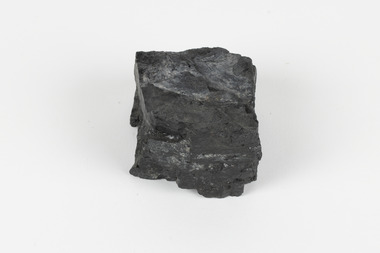
Geological specimen - Bituminous Coal, Unknown
... geological ...Bituminous coal is the most common type of coal, abundantly found in ancient coal deposits which can be dated back millions of years. Often referred to as soft or black coal, this specimen exhibits a high carbon content, ranging from 76-86%. It also holds a relatively high energy density (27 MJ/kg) meaning that it releases significant amounts of energy when burned. Bituminous coal is most commonly used for electricity generation, as well as in the production of steel. This particular piece of coal was collected as part of the Geological Survey of Victoria in the nineteenth century. It originates from Cape Paterson, a seaside village located in South Gippsland, Victoria (located on Bunurong Country). The discovery of bituminous coal in this locality was first made in 1826 by explorer William Hovell. More discoveries were gradually made over the following decades and in 1859 the Victorian Coal Company commenced the first active coal mining operations in the state by sinking a number of shafts and bores near the area of Cape Paterson. Evidence of this coal-focused past can be found today at the State Coal Mine Museum in the nearby town of Wonthaggi. This specimen is significant as it was collected from the locality of Cape Paterson in Victoria, an area that has since become historically instrumental in the mining of coal and other substances in the state of Victoria. This specimen is part of a larger collection of geological and mineral specimens collected from around Australia (and some parts of the world) and donated to the Burke Museum between 1868-1880. A large percentage of these specimens were collected in Victoria as part of the Geological Survey of Victoria that begun in 1852 (in response to the Gold Rush) to study and map the geology of Victoria. Collecting geological specimens was an important part of mapping and understanding the scientific makeup of the earth. Many of these specimens were sent to research and collecting organisations across Australia, including the Burke Museum, to educate and encourage further study. A solid hand-sized piece of bituminous coal with a shiny black-grey surface and jagged edges.Existing Label: BITUMINOUS COAL / Locality: Cape / Patterson, VIC. burke museum, beechworth, geological, geological specimen, state coal mine museum, wonthaggi coal mine, victorian coal company, bituminous coal, coal victoria, coal energy generation, william hovell, cape paterson, coal specimen -
 Kiewa Valley Historical Society
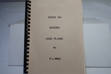
Book - Notes on Bogong High Plains by E. J. Minty, Notes on Bogong High Plains by E. J. Minty
The book includes detailed accounts in 4 sections of 1. History and Exploration 2. General Geology 3. Vegetation and slide set index 4. Climate ...Important knowledge/study for the construction of the Kiewa Hydro Electric Scheme on the Bogong High Plains.Cream cardboard cover book with black spiral binding. Title printed in black on cover. 46 pages printed on both sides includes diagrams. Clear blue plastic sheet as last page.e. j. minty, bogong high plains, kiewa hydro electric scheme -
 Bendigo Historical Society Inc.
Map - HUSTLER'S ROYAL RESERVE NO 2 CO - TRANSVERSE SECTION OF THE HUSTLER'S ROYAL RESERVE NO 2 CO
Transverse Section of the Hustler's Royal Reserve No 2 Co Mine on the Hustler's Line of Reef Bendigo, Bulletin No 33, Plate No VII. Section shows the poppet legs and the sill of Shaft at 707.65 ft above sea level, depth of levels, stone encountered and geological features. Geological Survey of Victoria emblem. H. Herman Director, W. Dickson Secretary of Mines and The Hon. J. Drysdale Brown MLC, Minister of Mines. Signed by H S Whitelaw, Underground Survey Office Bendigo, September 1913. mining, parish map, hustler's royal reserve no 2 co, h s whitelaw, undergrou;nd survey office bendigo, geological survey of victoria, h herman, w dickson, the hon. j drysdale brown mlc -
 Federation University Historical Collection
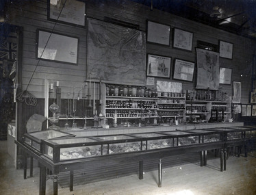
Photograph - Photograph (Black & White), Ballarat School of Mines Chemistry Room, c 1900
This image was taken at the height of the Ballarat school of Mines world wide fame.Black and white photograph mounted onto green card showing an interior chemistry classroom at the Ballarat school of Mines. Chemicals and apparatus line one wall, and geological specimens are housed in glass cases. Posters line the wall. On lower section of photograph 'Section Chemistry Room S.M.B. mines Dept Vic.ballarat school of mines, mines department, geology, chemisty -
 Port Melbourne Historical & Preservation Society
Book, Gary Presland, "The Place for a Village", 2008
"The Place for a Village" plus "how nature has shaped the City Of Melbourne" by Gary Presland. 265 page hard back book with green dustcover illustrating early Melbourne (1800s). Emphasis: Geology, climate, flora, faunaaustralian aborigines, natural environment, flora, melbourne, natural environment - fauna, gary presland -
Federation University Historical Collection
Booklet, Ballarat School of Mines Student's Magazine, Second Term, 1904, 1904
Table of contents: Editorial, Victorian School of Mines, Extraction of copper, The Diehl process, Analysis of materials used in assaying, Definitions of electrical terms, Mine managers - Practical and Unpractical, Geology at Lake Burrumbeet, Smelting argentiferous lead, Geology notes, Nature - Aphorisms by Goethe, Our illustrations, The estimation of a girl, The abolition of thunderstorms, Send-off to Messers L. Smith and S. Austin, Students' annual reunion, Correspondence, Past students, Diplomas and Certificates, Sports, News and notes, Editorial notes.Pale gray booklet of 18 pagesballarat school of mines, students' magazine, stephen hart, l. smith, s. austin, past students, f. a. marriott, l. j. lambert, h. krause, nettle, h. irwin,, a. atkins, l. seal, t. davis, r. robin, b. roy, d. elder, w. b. blyth, a. gillespie, j. huston, k. moore, obituary, alfred g. johnstone, cecil s. wakley., r. o. inglis, g. w. cornell, s. austin, s. g. turrell, l. seward, j. burrows, w. j. lakeland, douglas runting, godfrey s. hart, latham watson, samuel j. lindsay -
 Ringwood and District Historical Society
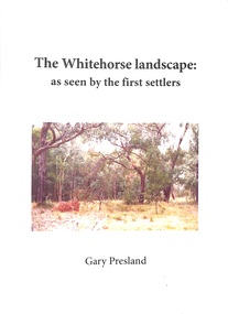
Book - Booklet, Gary Presland, Booklet titled 'The Whitehorse Landscape' as seen by the first settlers by Gary Presland, 2011. Contains photographs of flora and fauna plus details of the local weather and geology, 2011
The Whitehorse Landscape as seen by the first settlers contains elements of natural history, geology, weather, local hydrology, vegetation and Fauna. With list of sources, glossary of terms and index. With photographs.25 page booklet, indexed. White covers with picture on front and embedded in the text. +Additional Keywords: Presland, GaryThe Whitehorse Landscape' -
Lakes Entrance Historical Society
Book, Pitt M W and Synan T P, The Past Present and Future of the Gippsland Lakes, 1987
Edited account of the papers presented at the Save the Gippsland Lakes Committees symposium on Lake Wellington and Lake Coleman held in Sale, November 1986. Includes history, geology, flora and fauna, and the many aspects of human impact on the region. Ilwaterways, government -
 Bendigo Historical Society Inc.
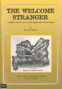
Book - BOOK: THE WELCOME STRANGER - A DEFINITIVE ACCOUNT OF THE WORLDS LARGEST ALLUVIAL GOLD NUGGET, 1999
This alluvial gold nugget was discovered in 1869 at Moliagul, by Cornish miners, John Deason and Richard Oates. It's gross weight was 109.51 kg and net weight of gold was 72.02 kg. It was melted down and the ingots sent to the Bank of England.Softcover book with gold coloured cover with a sketch of the Welcome Stranger nugget on the front and a blurb on the back. Contains 50 pages covering the history, myths, geology, details of the discoverers and the discovery of the nuggett. Contains black and white photographs and sketches.Terry F Pottergold -
 Bendigo Historical Society Inc.
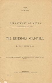
Document - MCCOLL, RANKIN AND STANISTREET COLLECTION: THE REDESDALE GOLDFIELD, 1909
1909 report from the Department of Mines Geological Survey on the Redesdale Goldfield by E. J. Dunn. F.G.S. Reefs mentioned are the Horseshoe Bend Reef, Linda Reef, Bill Smith's workings, the Ben Guy Reef and the Amelia ReefDepartment of Minesgold mining, miners' safety cage, redesdale goldfield, gold mining, redesdale. -
Lakes Entrance Historical Society
Book, Land Conservation Council Victoria South Gippsland Area District 2, 1980
Report describing and assessing the natural resources of the public land in the South Gippsland (Victoria) Study Area 2, comprising the Latrobe Valley, Strzelecki Range, South Gippsland coastal plains and all of Wilson's Promontory. History, Geology, floRuth Clarkgippsland, topography, natural history, vegetation -
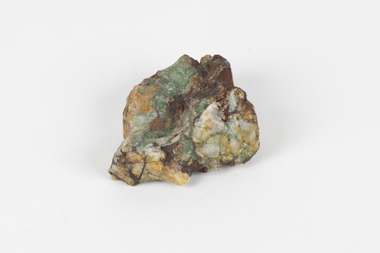 The Beechworth Burke Museum
Geological specimen - Malachite in Conglomerate, Unknown
... geological ...Malachite is a green copper carbonate hydroxide mineral and was one of the first ores used to make copper metal. Malachite has been utilised as a gemstone and sculptural material in the past as its distinctive green color does not fade when exposed to light or after long periods of time. Malachite is formed at shallow depths in the ground, in the oxidizing zone above copper deposits. The material has also been used as a pigment for painting throughout history. Malachite is considered a rare gemstone in that the original deposits for the stones have been depleted leaving behind very few sources. In addition, the use of Malachite as gemstones and sculptural materials remains just as popular today as they were throughout history. It is quite common to cut the stone into beads for jewellery. The fact that Malachite has such a rich colour and one that does not fade with time or when exposed to light makes it particularly rare. Although there is no indication available of the locality from which the specimen was sourced, it is likely that the specimen was collected either in South Australia in the vicinity of the Burra Burra mines or in Victoria as part of programs of geological surveying undertaken in the Nineteenth and Twentieth centuries. This specimen is part of a larger collection of geological and mineral specimens collected from around Australia (and some parts of the world) and donated to the Burke Museum between 1868-1880. A large percentage of these specimens were collected in Victoria as part of the Geological Survey of Victoria that begun in 1852 (in response to the Gold Rush) to study and map the geology of Victoria. Collecting geological specimens was an important part of mapping and understanding the scientific makeup of the earth. Many of these specimens were sent to research and collecting organisations across Australia, including the Burke Museum, to educate and encourage further study.A solid hand-sized copper carbonate hydroxide mineral with quartz pebbles in red conglomorate matrix presenting shades of cream, brown and green.Existing label: Malachite / (green) in / conglomerate / (white quartz / pebbles / in red matrix /geological specimen, geology, geology collection, burke museum, beechworth, geological, indigo shire, malachite, malachite specimen, australian mines, mines, geological survey, conglomorate, matrix -
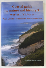 Warrnambool and District Historical Society Inc.
Book - Coastal Western Victoria, Graham Patterson, Coastal Guide to Nature and History 3 Western Victoria, 2022
Description of Western Victorian Coast from Point Lonsdale to South Australian BorderThis is a book of 188 pages. The cover has colour photographs and printing in red and white. The pages contain printed text, maps and illustrations, and black and white and colour photographsnon-fictionDescription of Western Victorian Coast from Point Lonsdale to South Australian Borderwestern victoria coastline, graham patterson, warrnambool, shipwreck coast -
 Federation University Historical Collection
Book, Mining Engineers Handbook Volume 1 & 2, 1941
The book was used by Charles Bacon who studied at the University of Nevada in the late 1930s/early 1940s. Bacon worked at Bunker Hill Mines and Kellogg Idaho, before arriving in Australian in 1951. He worked for CN Myers, a company involved with paper converting. CN Myers was a family business (on Charles Bacon's maternal line). Robert Peele was Professor Emeritus of mining Engineering at the School of Mines, Columbia University.Maroon hardcovered books. .1) Volume 1 - Chapters include Mineralogy, Geology and Mineral Deposits, Earth Excavation, Explosives, Rock Excavation, Tunneling, Shaft Sinking in Rock, Shaft sinking in Unstable and Waterbearing Ground, Boring, Underground Transport, Mine Ventilation. .2) Volume 2 - Chapers include Compressed Air Practice, Electric Power for mine Service, Surveying,Underground Surveying, Mine Geologic Maps and models, Cost of mining, Mining Laws, Ore sampling, Assaying, Aerial Tramways and Cableways, Gold Amalgamation and Cyanidation, etc.Inside front cover "Charles Bacon"charles bacon, mining engineering, mining, engineering, university of nevada, mackay school of mines, explosives, timbering -
 Bendigo Historical Society Inc.
Document - CAROL HOLSWORTH COLLECTION: GEOLOGICAL REPORT BENDIGO GOLDFIELD
Four page document, an extract from the Geological Report on the Bendigo Goldfield. On front page, a line drawing of a puddling machine. Contents include: alluvial mining, reef mining, the boom years, deep sinking, decline of mining, modern exploration, physiography, the hills, the valleys and the soils. A table demonstrates the development of graptolite structures, including the Lancefieldian, Bendigonian, Chewtonian and Castlemainian graptolite species. Two diagrams demonstrate saddle and bedded reefs and fault reefs. Written on top of the document: C.E. William and H.E. Wilkinson, 1992. Geological Survey Report No. 93.bendigo, mining, geological bulletin 93 -
 Bendigo Historical Society Inc.
Map - HUSTLER'S REEF & HUSTLER'S REEF NO 1 MINES - PLAN OF THE HUSTLER'S REEF & HUSTLER'S REEF NO 1 MINES
Plan of the Hustler's Reef & Hustler's Reef No 1 Mines on the Hustler's Line of Reefs Bulletin No 33, Plate No XV. Plan shows the two mines with depth of levels, geological features and levels in relation to the shaft. Geological Survey of Victoria emblem and signed by H A Whitelaw, Underground Survey Office Bendigo, September 1913. Note - The Lease Boundaries shown on this plan are only in their approximate relative positions to Nos 13, Intermediate and 14 Levels of the Hustler's Reef No 1 workings, and Nos 15, 16 and 17 Levels of the Hustler's Reef workings.mining, parish map, hustler's reef & hustler's reef no 1 mines, geological survey of victoria, underground survey office bendigo, h a whitelaw, hustler's line of reefs -
 Bendigo Historical Society Inc.
Map - HUSTLER'S REEF NO 1 MINE - TRANSVERSE SECTION OF THE HUSTLER'S REEF NO 1 MINE
Map of a transverse Section of the Hustler's Reef No 1 Mine on the hustler's Line of Reefs Bulletin No 33, Plate No XXI. Map shows poppet legs at 801.07 feet above Sea Level and drawing of shaft with the different levels. Also shown are geological features and stone encountered. Geological Survey of Victoria emblem H Herman, Director, W Dickson, Secretary of Mines and The Hon. J. Drysdale Brown MLC Minister of Mines. Signed by H S Whitelaw, Underground Survey Office Bendigo, September 1913. This item has not been scanned or photographed.mining, parish map, hustler's reef no 1 mine, hustler's line of reefs, geological survey of victoria, underground survey office bendigo, h s whitelaw, h herman, w dickson, the hon j drysdale brown -
 Bendigo Historical Society Inc.
Map - HUSTLER'S ROYAL RESERVE NO 2 (PARK SHAFT.) - TRANSVERSE SECTION OF THE HUSTLER'S ROYAL RESERVE NO 2
Transverse section of the Hustler's Royal Reserve, No 2 (Park Shaft.) on the Hustler's Line of Reef. Bulletin No 33, Plate No IX. Section shows poppet legs and sill of shaft at 755.70 ft above sea level, depth of levels, type of stone encountered including lava and geological features. Geological Survey of Victoria emblem and beneath it H. Herman, Director, W. Dickson, Secretary of Mines and The Hon. J. Drysdale Brown MLC Minister of Mines and signed by H S Whitelaw, Underground Survey Office, Bendigo September 1913.mining, parish map, hustler's royal reserve no 2 (park shaft.), h s whitelaw, underground survey office bendigo, geological survey of victoria, h herman, w dickson, the hon j drysdale brown mlc, hustler's line of reef -
 The Beechworth Burke Museum
Geological specimen - Greenstone / Gabbro, Unknown
This specimen was recovered from Ceres West of Geelong, Victoria. Greenstone is the name for any metamorphosed basic igneous rock (in the case of this specimen, Gabbro) that gains its greenish colour to the presence of the minerals chlorite, actinolite, or epidote, hence the term 'green' and 'stone'. Greenstone is often formed through metamorphsis along a convergent plate boundary. In the rock cycle (the series of processes that creates the various types of rocks) there are identified three different types of rocks, which are the sedimentary, the igneous and the metamorphic. Metamorphic rocks started out as sedimentary, igneous or earlier metamorphic rocks but changed from their original condition under the effect of high heat, high pressure or hot, mineral-rich fluid. However, if pressure or heat is too high, then the rock will melt, resulting in the formation of an igneous rock. The name used to describe these types of rocks reflects this specific inherent trait of change, since the word “metamorphic” derives from the Greek word “metamorphosis”, meaning “change of form or structure”. Metamorphic rocks form in the Earth`s crust but can be also found on the surface, due to elevation of the Earth`s surface. They are divided into two categories: the foliated metamorphic and the non-foliated metamorphic rocks. Gabbro is a highly useful mineral that is often polished to create cemetery markers and kitchen benches. It is notable for its qualities of durability, being able to withstand extreme elements and wear. Whilst not rare, Gabbro is of great utility and has been highly desirable for its qualities. This specimen is part of a larger collection of geological and mineral specimens collected from around Australia (and some parts of the world) and donated to the Burke Museum between 1868-1880. A large percentage of these specimens were collected in Victoria as part of the Geological Survey of Victoria that begun in 1852 (in response to the Gold Rush) to study and map the geology of Victoria. Collecting geological specimens was an important part of mapping and understanding the scientific makeup of the earth. Many of these specimens were sent to research and collecting organisations across Australia, including the Burke Museum, to educate and encourage further study.Greenstone is a solid hand-sized metamorphic mineral of a green colour. Greenstone is the name for any metamorphosed basic igneous rock (in the case of this specimen, Gabbro) that gains its greenish colour to the presence of the minerals chlorite, actinolite, or epidote, hence the term 'green' and 'stone'. Gabbro is a medium to coarse grained rocks that consist primarily of plagioclase feldspar and pyroxene. Greenstone is often formed through metamorphsis along a convergent plate boundary. Gabbro forms due to cooling and crystallization of magma underneath Earth's surface. Greenstone/Gabbro/from Ceres west/of Geelong. Has old Geological Survey label/and probably collected by/Richard Daintree in 1861/C.Willam 15/4/21/ Other label: 62 /greenstone, metamorphosed, igneous rock, gabbro, chlorite, actinolite, epidote, metamorphsis, rock cycle, various types of rocks, sedimentary, high heat, high pressure, mineral-rich fluid, metamorphosis, foliated metamorphic, non-foliated metamorphic, convergent plate boundary, greenish colour, minerals -
Bendigo Historical Society Inc.
Book - DEPARTMENT OF MINES 1914 BULLETINS OF THE GEOLOGICAL SURVEY OF VICTORIA NO. 33. HUSTLER'S LINE OF REEF, BENDIGO, 1914
Department of Mines 1914 Bulletins of the Geological Survey of Victoria No. 33. Hustler's Line of Reef, Bendigo. Photos of the mines on the Hustler's Line of Reef. 59 pages plus 7 pages of photos. Inscribed A. Richardson 29 Harrison street, BendigoDepartment of Mines.bendigo, mining, hustler's line of reef, mining, and hustler's reef mines. -
 Bendigo Historical Society Inc.
Book - MINING & GEOLOGICAL JOURNAL. VOL,4. NO.3, 1951
Mining and Geological Journal, Vol.4, No.3. March 1951. Published by Department of Mines Victoria with articles on Mines & mining including Bendigo mines with Photographs, Illustrations, Maps & Advertisements. Name on front A.Richardson 29 Harrison St Bendigo.Dept of Mines Victoria.gold mines, mining, mining - mines - mining equipment, central deborah mine. -
 Bendigo Historical Society Inc.
Book - MINING & GEOLOGICAL JOURNAL. VOL.S,NO.6, 1942
Mining & Geological Journal, Vol.2, No.6. March 1942. Published by Department of Mines Victoria, with articles on mines and mining including Bendigo mines, Photographs, Illustrations, Maps & Advertisements. Name on cover A Richardson 29 Harrison St Bendigo.Dept of Mines Victoriagold mines, mining, mining - mines - mining equipment. bendigo mines. -
 Bendigo Historical Society Inc.
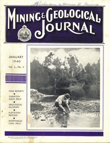
Book - MINING & GEOLOGICAL JOURNAL VOL.2, NO2, 1940
Mining & Geological Journal, January 1940, Vol.2, No.2. Published by Department of Mines Victoria, 136 pages of Mine Reports, articles on mines, photographs, illustrations, maps & advertisements. Name on cover A.Richardson 29 Harrison St Bendigo.Dept of Mines Victoriagold mines, mining, mining - mines - mining equipment, axedale - fletchers mine. -
 Bendigo Historical Society Inc.
Document - CAROL HOLSWORTH COLLECTION: GEOLOGICAL REPORT BENDIGO GOLDFIELD BULLETIN 43
Four page document Geological Report Bendigo Goldfield, C.E. Willman and H.E. Wilkinson. Contents include: folds, cleavage, lineations, lineated quartz in laminated veins, faults, major and minor faults, joints, structural domains and relationship to mineralization.bendigo, mining, geological bulletin -
 Kew Historical Society Inc
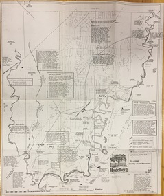
Plan, Loder & Bayly, Heidelberg: Historic River Landscape Assessment, 1982
Gwen McWilliam is well known as an authority on the history of Boroondara and the author of a large number of books and pamphlets about the City. She was awarded the medal of the Order of Australia in 2001 ‘for service to the community of Hawthorn and district, particularly through the research, documentation and publication of its history.’ This map from her collection was donated to the Kew Historical SocietyPlan of Heidelberg, annotated with details about the occupancy pre and post European settlement. The plan also contains geological references. The plan is included and analysed in volume 2 of the Heidelberg Conservation Study (1985). The original plan was published created in 1982. Printed annotationscity of heidelberg, yarra valley, historic plans -- heidelberg -
 Bendigo Historical Society Inc.
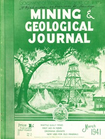
Book - MINING & GEOLOGICAL JOURNAL VOL.2, NO 4, 1941
Mining & Geological Journal, March 1941, Vol.2, No.4. Published by Department of Mines Victoria, 136 pages of Mine Reports, articles on mines, photographs, illustrations, maps & advertisements. Name on cover A.Richardson 29 Harrison St Bendigo.Dept of Mines Victoriagold mines, mining, mining - mines - mining equipment, axedale - fletchers mine. -
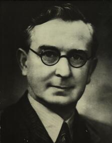 Federation University Historical Collection
Photograph, Dr Charles Fenner, Principal Ballarat School of Mines, 1914-1916
Charles Fenner graduated in Science with honours and Diploma of Education in Melbourne. He became Principal of Ballarat School of MInes in 1914 and moved from there in 1916. Lectured in Geology at the Ballarat School of Mines.Photographic portrait of a male wearing glasses. charles fenner, ballarat school of mines, geology