Showing 327 items
matching grazing land
-
 Nillumbik Shire Council
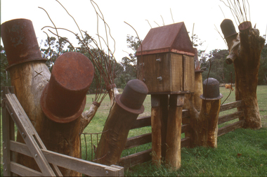
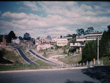
Sculpture: Tony Trembath (b.1946 Sale, Victoria), Tony Trembath, The Fences Act 1968 - Location: Edendale Farm (entrance) 30 Gastons Road, Eltham, 1989 - 1994
Eltham Council (now the Shire of Nillumbik) commissioned this work in 1989 to create an entrance / gateway to Edendale Community Farm. It was also aided by a grant from the Ministry of the Arts (now Arts Victoria). The former name of this work was "Gateway to Edendale Farm". Edendale Farm is a demonstration farm modelling sustainable environmental practices, providing support to the local residents of Nillumbik. Established in 1986, the land was purchased in 1970. It was previously an English gentleman's residence and was used for grazing. It consists of 5.6 hectares, with the Diamond Creek meandering through the property. The Victorian Fences Act 1968 governs liability of occupiers of adjoining lands to fence, and deals with disputes between neighbours regarding boundaries fences and costs. This work took into consideration ideas and suggestions from residents and committees, who required the use of recycled materials and that the work celebrate man's relationship with nature, animals and the earth, as well as relate to the fence-line on the far side of the carpark. Trembath also absorbed significant aspects of local history, making references to Eltham's agricultural past, the clearing of the land, the destruction of trees, the ruthless pruning of trees by suburban Councils and incorporated such Australian features as the post and rail fence. 'The Fences Act 1968' is significant for aesthetic, historic and social reasons at a regional level. It makes prominent the historical and social significance of Edendale and the rural aspects of Nillumbik. The use of existing tree stumps and salt pots in the work explores the iconography of the countryside such as the isolated farmhouse, pioneering farming practices, post and rail fencing and the regrowth of lopped trees. The title of the work, as well as the extensive community involvement in its creation, also makes reference to the Victorian Fences Act 1968, which makes neighbours jointly responsible for the cost of construction and maintenance of fences in the partitioning of land for settlement. 'The Fences Act 1968' has been classified as of regional significance by the National Trust of Australia. The work is an installation of wood and metal, approximately twenty five meters long. The design is very informal and rustic and runs the full width of the fence-line. It comprises groups of recycled tree trunks fitted with metal caps (chrome-nickel 'salt pots' that are shaped like tall bowler / top hats). Metal rods protrude from the trunks and some of these rods have metal birds. Two larger, sentinel-like stumps at the two outer ends have metal flame-like wings, which bend inward. To the left of the entrance, a simple architectural element indicates an isolated farmhouse. The rustic fence runs between the groups of tree trunks with native planting in clumps along it. The fence-line incorporates a functional engineered double gate and post and rail fencing. There may be many interpretations of the work and the intention is to stimulate interest and imagination rather than alienate. Interpretation is based on the personal experience that a visitor brings. The artist recommended that no explanation of the design logic be positioned with the work. N/Apublic art, sculpture, edendale, recycled, wood, metal, fences act 1968, gate, trembath, salt pot, tree stumps -
 Stawell Historical Society Inc
Book - Report, Grampians: A Report on recreation and Timber Uses of. Too Steep to Graze - Too Rocky to Plough, 1979
1) Conservation & Economics 2) Grampians Study Area 3) Land Use 4) Management 5) Criticisms of the Management Plan Appendix Graphs & MapsGreen Paper cover: Black tape on SpineConservation council of Victoria and Logo -
 National Wool Museum
Painting, The White Farm, 2020/21
The farm buildings that Linda Gallus has studied and painted are on the farmland adjoining the Leura Park properties in Curlewis, on the Bellarine Peninsula. The current owner of the property told Linda that he bought the farm in 1994. He has used it for both sheep and cattle grazing since purchasing the property. When the farmer bought the land all the buildings on the property were painted white for sale, despite the fact they were very old. The shearing shed was in use up until the time of sale but was in a bad state of disrepair. The roof, stumps and floor required replacing. The building was no longer in use after the sale, so the shearing shed gradually fell into further disrepair. The previous owner had also used the property for growing potatoes, crops and livestock, mainly sheep. Linda’s fascination with the property came when she caught a glimpse of the white chimney over the hill driving towards Point Lonsdale, which still stands proud today on the roof of the old shearing shed. The owner kindly allowed her to visit the property over the past few years to capture the buildings using photography and painting. During this time many of the buildings have fallen. Linda calls it The White Farm as there are remnants of that original white paint on the outside of most of the buildings giving it a strange and rather beautiful patina. The structures are wonderful remnants of the history of the Bellarine. Linda first spotted the old shearing shed when she was driving home to Clifton Springs from Geelong. It was the white chimney on the shearing shed that stood out behind the rolling grassy hills. It was intriguing – bright white and still in good condition, unlike the rest of the building. After further investigation Linda got to know the owner of the property and visited it frequently to draw, take photos and paint. There is a variety of lovely old buildings on the property, but it was the shearing shed that held extra fascination for Linda. The most intriguing thing for Linda was that the buildings were all painted white at some stage and now the patina of peeling paint and bleached timber brought a wonderful mood and feeling to the farm. This is what she has tried to capture in this series of 11 paintings. Most of the buildings are falling, so Linda felt an urgency to capture them using acrylic paint on canvas in order to commemorate them forever.Acrylic Paint on Canvas. The images both feature a falling down shearing shed as the central focus. The wood of the shearing shed is a central theme of importance. The old buildings were painted white for sale despite being in a state of structural instability. After time this same painted wood has been left with an interesting complex patina like film on the surface which the artist has taken great care to capture. Image 1 is titled ‘Another gust of Wind’. It shows the exterior of the shearing shed which is in the process of collapsing from the forces of mother nature. In the background of this painting another of the buildings in the ‘White Farm’ complex is visible, in addition to blue skies and overgrown green grasses. Image 2 is titled ‘Green Trough’. It features the interior of the same collapsing shearing shed. The image is painted as though the viewer is peering through a crack of the external wall. Internally a green trough is seen hanging on an internal fence. Unlike everything else in the shearing shed, the trough appears new and in good condition. It provides a strong juxtaposition to the rest of the shearing shed, and the larger surrounding ‘White Farm’ complexbellarine peninsula, the white farm, shearing shed -
Hume City Civic Collection
Photograph, Lois Alexander, Goonawarra Winery, 1986
It is a photograph of Goonawarra Winery that was first established by James Goodall Francis, who in 1863 applied to lease 26 acres of land on the condition that he plant vines on some of it. The property continued to be worked as a vineyard by him and his son, Wilfred, until the late 1920s when wool and mutton were production were preferred to wine production and the vines were pulled out. The Carmody family purchased purchased the property in 1961 and used it for grazing until 1976, when they replanted vines there. In the early 1980s, John and Elizabeth Barnier purchased the property and continued to run the property as a vineyard.Goonawarra is one of the earliest vineyards and wineries to be established in Sunbury. A non-digital coloured photograph of a large winery building.goonawarra vineyard, john barnier, elizabeth barnier, james goodall francis, sunbury road, vineyards., winery -
 Otway Districts Historical Society
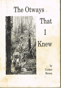
Book, Merimbula Easiprint, The Otways that I knew, 1993
Condensing 100 years of Otway history the author tries to give an insight into the thoughts and ways of the settlers in opening the western Otway Ranges. It gives some indication of the mental pressure, hand-in-hand with the physical stress, as a settler cleared the land and made a living for his family. It covers how the rail link brought in the timber mills and their workers which made timber the main industry of that era, and covers the changes that took place in the 1930s as the mills closed down and the district raised crops, dairying and grazing.The Otways that I knew. Ronald Charles 'Corker' Brown. 1st ed. Corker Brown; np; 1993. 216 p.; illus; maps. Soft cover. ISBN 0 646 16798 7otway ranges; corker brown; otway lighthouse; aborigines; beech forest; farming; grazing; crops; railways; roads; timber; -
 Kew Historical Society Inc
Photograph, J F C Farquhar, The Yarra in Hyde Park, 1891
At the beginning of the 1890s, the Kew businessman and Town Councillor, Henry Kellett, commissioned J.F.C. Farquhar to photograph scenes of Kew. These scenes included panoramas as well as pastoral scenes. The resulting set of twelve photographs was assembled in an album, Kew Where We Live, from which customers could select images for purchase.The preamble to the album describes that the photographs used the ‘argentic bromide’ process, now more commonly known as the gelatine silver process. This form of dry plate photography allowed for the negatives to be kept for weeks before processing, hence its value in landscape photography. The resulting images were considered to be finely grained and everlasting. Evidence of the success of Henry Kellett’s venture can be seen today, in that some of the photographs are held in national collections.It is believed that the Kew Historical Society’s copy of the Kellett album is unique and that the photographs in the book were the first copies taken from the original plates. It is the first and most important series of images produced about Kew. The individual images have proved essential in identifying buildings and places of heritage value in the district.Hyde Park is now a small recreation reserve bordered by Willsmere and Kilby Roads and White Avenue. In 1982, Hyde Park was cut off from the Yarra River by the construction of the Eastern Freeway. The building of the latter was to transform the natural landscape, including the Yarra, as well as Hyde Park. The construction of the Freeway makes it difficult to view the scene with the photographer’s eye. Today’s Hyde Park is located on land purchased in 1847 by John Cowell, and in 1851 Catherine Cowell, yet the scene selected by the photographer may well have been located on farmland owned by the Wills family. Farquhar’s point-of-view emphasises both the pastoral and recreational elements of the scene: the grazing cows, three boys, and in the distance two figures, seated on the bank with a parasol. By 1891, an environmental consequence of human activity, including farming, was deforestation, leading to the erosion of the south bank of the Yarra. In contrast, the land on the Alphington side of the river in 1891 included remnant bushland.The Yarra in Hyde Parkkew illustrated, kew where we live, photographic books, henry kellett, yarra river -
 Surrey Hills Historical Society Collection
Photograph, Muriel Pornitz (deceased), Quarry on site of Grovedale Road - James Street Park
The photo is of a painting of the dam formed on land between Grovedale Road and James Street, Surrey Hills. It was painted in 1927 by Miss Muriel Pornitz, an art teacher, who lived in Grovedale Road. The land had been part of Mr James Maling Snr’s property and in the 1880s clay was removed to build houses, including his own located on the corner of Weybridge and James Streets. Maling grazed cattle on this area and used it as a dam. The land was subsequently made into parkland, the quarry / dam having been filled in after several drownings had occurred in the 1920s/1930s. See also SHP94, another copy of the same. Muriel Hedwig Lucy Pornitz lived at 22 Grovedale Road, Surrey Hills. She was born c1894 in Balwyn; died in Kew on 1 December 1982. She was the daughter of Konrad Pornitz (1864-1903) and his wife Charlotte Richardson Gooderidge (1863-1942), known as Tottie, who married in 1890. Konrad Pornitz is listed in the 1892 directory as living in Edgevale Road, Kew and the business Pornitz and Ross at 291 & 293 Little Collins Street, importers and commission merchants. The 1896 directory gives the Kew address as 176 Edgevale Road, Kew, however the business Pornitz and Ross was dissolved on 1st day of October 1892, by mutual agreement. Legal notice advised that: Mr Pornitz will hereafter carry on the business on his own behalf at the same address, under the style "Pornitz and Ross". Muriel is buried in Box Hill Cemetery (B-086-0042) along with Ulrich Horst Holm Pornitz known as Horst or Bon (d 1957) and Edith Olga Pornitz (d 1951), her brother and sister. A further sibling (Konrad b 1891) died in infancy. He is buried with his mother in Boroondara (Kew) Cemetery - C/E A 0366. Konrad died at his home 'Yarran' in Lane Cove Road, North Sydney on 31 October 1903; reported in the Sydney Morning Herald. Buried Gore Hill Cemetery, St Leonards, North Sydney. The headstone reveals he was born in Chemnitz, Saxony in 1863. Muriel was also known as Muriel Pornett. She studied at the South Australian School of Arts & Crafts in 1911 under James Ashton and Fred Britton, and at the Australian School of Etching in Sydney. She was also an illustrator and cartoonist. The photo, and the painting from which it is derived, documents the landscape prior to close settlement and is material to early building and farming in the Surrey Hills area.A black and white photograph of a painting of a landscape of parkland. Two trees are on top of a rise and are reflected at the bottom in water. The signature of the artist is in the bottom right corner: "AUST MP 192" (and the rest is cut off).(miss) muriel pornitz, grovedale road, james street, surrey hills, artists, parks and reserves, (mr) john butler maling, snr, quarry, dam, (miss) muriel hedwig lucy pornitz, box hill cemetery, muriel pornett -
 Surrey Hills Historical Society Collection
Photograph, Norman Carter, Part of Black's dairy farm in Mont Albert in the 1920s, 1920s
Photo is likely to have been taken pre-1924 when the land was subdivided. Donor information is that this was taken from a home in Churchill Street, Mont Albert; it would be looking south towards Mont Albert Road. Black's dairy farm occupied the area just east of Hamilton Street to near Elgar Road. It was subdivided into 88 house allotments along Churchill Street, Bruce Street, Black Street, Proudfoot Street and View Street. The solicitors were Proudfoot & Horton, 360 Collins Street; estate agents were Duncan & Weller, 29 Queen Street. The real estate subdivision notice on the SLV website states that Neil Black had been the owner for 50 years. To date no trace of a Neil Black has been found. Box Hill rate books simply give BLACK as the owner in 1877 (no first name); the entry for 1878-1884 states Robert Black. The 1909 electoral roll has entries for Mont Albert Road for Robert Black (farmer), Thomas Black (carter) & Elizabeth Black (HD). The 1912 electoral roll has entries for Mont Albert Road for Robert Black (farmer), Thomas Black (labourer), John Arthur Black (carter) & Elizabeth Black (HD). Robert Black died in 1920 (b. 1836) and is buried in Box Hill Cemetery (CE-*-0057). His parents were John and Margaret Black. He married Lizzie Foley in 1878. She was the daughter of Margaret & John Foley, born in 1859. She died in 1902 aged 43 years and is probably buried in the same grave, although the cemetery records record her age as 0 years. Children: 1. James Hughbert (1880-1954) 2. John Arthur (1881-1959) 3. Alice (1882-1883) - died aged 6 months 4. Laura Elizabeth (1883-1951) 5. Thomas (1885-1965) 6. Isabella (1887-1963) 7. Eleanor (1889-1963) 8. Ada Maud (1890-1968) 9. Robert (1892-1930). BDM Victoria states places of birth as Box Hill, Surrey Hills or Mont Albert. Many of the family are buried in Box Hill Cemetery. None of the girls appear to have married. Communication from a descendant of John Arthur Black gives the following: "John Arthur Black, son of Robert & Lizzie Foley, married Gladys Anne Layton had 4 children, Robert, Elenore, Marion (Follett) & Annie; they had farm on Stud Road, Dandenong where they milked 30 cows that he retired to after being a earth-moving contractor with draft horses and dug irrigation ditches around Shepparton." This is important as documentation of the area's early farming land use.Black and white photo of a paddock with cows and sheep grazing. On the horizon is a simple cottage with a small veranda and 2 chimneys and scattered trees.black's dairy farm, dairying, farms, churchill street, black street, proudfoot street, bruce street, view street, neil black, proudfoot & horton, duncan & weller, robert black, lizzie black, lizzie foley, james hubert black, john arthur black, alice black, laura elizabeth black, thomas black, isabella black, eleanor black, ada maud black, robert black jnr, box hill cemetery -
 Port Fairy Historical Society Museum and Archives
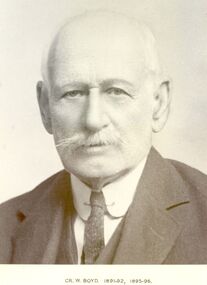
Photograph, Cr William Boyd Shire of Belfast President 1891-92 95-96
Councillor William Boyd was the son of Alexander Boyd who emigrated from Scotland and purchased the property known as Tarrone station in 1884. William managed the station grazing cattle and sheep. The area was later to become part of the Soldier Settlement land after the Second World War.Black and white portraitbelfast, president, government, portrait, shire, council, municipal, local-government, tarrone -
 Wodonga & District Historical Society Inc
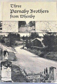
Book - Three Parnaby Brothers from Whenby, Julie Walker and Judy Crook, 2000
... to Belvoir (Wodonga). By August 1877 he owned 104 acres of grazing ...This book documents the story of the Parnaby Brothers who migrated to Australia from Whenby in North Yorkshire, England via Natal in South Africa. They settled in the Wodonga district of Victoria. The dedication on page 3 of the book says "To George, William and Matthew Parnaby. We can only wonder at the adventurous spirit, courage and fortitude of the three brothers who arrived in this country with an ambition to better themselves and provide for their families." George arrived at Port Melbourne from Port Natal on 11 January 1864. On the same voyage was his brother William and a nephew Charles. George and his wife Rachel settled at Howlong on the Victoria/NSW border where he worked as a farmer and labourer. George died at Howlong on 26 JUne 1887. William and his son Charles settled in Albury. In 1869/70 he was listed as a property owner at Wooragee, including a house, farm and vineyard. William died in Albury on 20 February 1894. Matthew originally arrived in Hobsons Bay, Victoria in 1854. After 6 years on the goldfields he returned to South Africa and then to England to marry. They eventually returned to Australia in 1863. After some time in Melbourne, Matthew moved to Belvoir (Wodonga). By August 1877 he owned 104 acres of grazing land at House Creek. He steadily became one of the most successful farmers in the district and increased his landholdings. He spent the remainder of his life in Wodonga where he served as a member of the Shire Council for some years. Matthew never forgot his birthplace and called his property "Whenby Grange". He died in Wodonga on 7 October 1903.A volume of 342 pages, including photos and maps. The cover includes images of the town of Whenby, maps and the grave of Matthew Parnaby who died in Wodonga on 7 October 1903.This book documents the story of the Parnaby Brothers who migrated to Australia from Whenby in North Yorkshire, England via Natal in South Africa. They settled in the Wodonga district of Victoria. The dedication on page 3 of the book says "To George, William and Matthew Parnaby. We can only wonder at the adventurous spirit, courage and fortitude of the three brothers who arrived in this country with an ambition to better themselves and provide for their families." George arrived at Port Melbourne from Port Natal on 11 January 1864. On the same voyage was his brother William and a nephew Charles. George and his wife Rachel settled at Howlong on the Victoria/NSW border where he worked as a farmer and labourer. George died at Howlong on 26 JUne 1887. William and his son Charles settled in Albury. In 1869/70 he was listed as a property owner at Wooragee, including a house, farm and vineyard. William died in Albury on 20 February 1894. Matthew originally arrived in Hobsons Bay, Victoria in 1854. After 6 years on the goldfields he returned to South Africa and then to England to marry. They eventually returned to Australia in 1863. After some time in Melbourne, Matthew moved to Belvoir (Wodonga). By August 1877 he owned 104 acres of grazing land at House Creek. He steadily became one of the most successful farmers in the district and increased his landholdings. He spent the remainder of his life in Wodonga where he served as a member of the Shire Council for some years. Matthew never forgot his birthplace and called his property "Whenby Grange". He died in Wodonga on 7 October 1903.parnaby family, whenby england, whenby grange wodonga -
 City of Kingston
Photograph - Black and white, 20 December 1945
Cheltenham is a suburb in the City of Kingston that was originally established as a rural market gardening community. The area is bordered by Highett, Mentone and Heatherton. The market gardens, farms and paddocks have gradually been sub-divided into housing and industrial estates. The Southland shopping centre is a major feature of the area.Cheltenham was established as a rural market gardening community. The Le Page family lived in Cheltenham since 1854 when Nicholas Le Page, a tailor from the Channel Island of Guernsey, bought two acres of land on Chesterville Road near Bernard Street to establish a market garden. Over the years the Le Pages purchased more land in the area. In 1875-76 Nicholas' son Frank and his wife Mary built 'Daphne Cottage' near the corner of Bernard and Wilson Streets. n the 1940s Frank's son, Everest Le Page, bought five more lots of land in Chesterville Road from the Tuck family. The Le Pages grazed horses, ponies and cows on this land, and grew pumpkins, carrots, parsnips, onions, potatoes and cabbages. Many buildings and locations within in Cheltenham commemorate the Le Page family's contribution to the Cheltenham community.Aerial photograph taken in 1945 of the Cheltenham district within the City of Kingston. The image includes Chesterville Road, the future site of Turner Road pool (now Waves) and Highett Reserve, (top left), Jellicoe Street, Argus Street, Bernard Street, Wilson Street, the Methodist Children Homes (now Southland), McIvor Street, Goulburn Street, Nepean Highway, Jamieson Street and Barker Street (bottom left), market gardens and paddocks. In the top centre of the image, "Daphne Cottage", the home of Frank T. Le Page is visible on the corner of Bernard and Wilson Streets. Much of the land depicted in this image was owned by the Le Page family. This image is possibly from the collection of aerial photographs commissioned by the Department of Crown Lands and Survey and taken by Adastra Airways.Black and white ink: 57250 White print: VIC-170 57250 20.12.45 Run 6 PROJ. No. 5 MELB. METROP AREA Black type 10200 FTS 30' LENS 20.12.45cheltenham, market gardens, industry, le page family -
 Linton and District Historical Society Inc
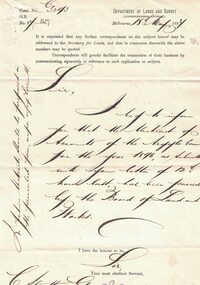
Letter, Paper manufactured by T. Edmonds 1890 (watermark), Department of Lands and Survey, Argyle Common, Linton, 1897, 18.05.1897
Letter written on behalf of Tho. MacGibbon, Secretary for Lands, to C. Stratton, Secretary, Argyle Common, Linton. Acknowledging receipt of Argyle Common accounts for 1896, and informing of their passing by the Board of Land and Parks. Also requesting that in future the accounts should be prepared on the prescribed form, a copy of which was enclosed. Found in the home of Miss Margaret Gorman after her death. See form sent with letter - Registration No. 1617Handwritten letter on grey paper headed Department of Lands and Survey, dated 18th May 1897. Addressee C. Stratton Esq.-Secretary-Argyle Common-Linton.argyle common linton, animal grazing, agricultural activity -
![Map, [Coornmill land area available for leasing for grazing, Parish of Coornmill]. Circa 1904](/media/collectors/5e461d8021ea67224c82f2a1/items/677cde147f2053f3e5d277c3/item-media/677cdeea7f2053f3e5d27bb4/item-fit-380x285.jpg) Bacchus Marsh & District Historical Society
Bacchus Marsh & District Historical SocietyMap, [Coornmill land area available for leasing for grazing, Parish of Coornmill]. Circa 1904
This map shows an area of land north of Bacchus Marsh in the Larderderg State Park area known as the Parish of Coornmill.The map indicates an area of land which was to be made available by public tender for grazing leaseholders. The plan to do this was discussed in the Bacchus Marsh Express newspaper on the 16 July, 1904, page 2, column 7. The area reserved for grazing leases is identified by red lines on the map. The Express described the area available for grazing was 12,000 acres.A single page paper map showing an area of land in the Parish of Corrnmill to be made available for grazing leases. A photo lithographed Lands Department Map. No scale indicated. The map is pasted into a bound volume containing 76 maps or plans in total. High resolution digital image stored on BMDHS computer network. coornmill parish maps, lerderderg state park maps, agriculture bacchus marsh area -
 Eltham District Historical Society Inc
Photograph - Digital Photograph, Alan King, Golden King Mine poppet-head, Yarrambat Primary School, 1 February 2008
The Golden King Mine poppet-head stands at the school’s Yan Yean Road exit gate. Published: Nillumbik Now and Then / Marguerite Marshall 2008; photographs Alan King with Marguerite Marshall.; p23 Early Yarambat - Tanck's Corner Its early settlers, who in the 1840s were amongst the first non-Aboriginal people in the area, found life tough as they grazed their sheep and cattle. Yarrambat was then known as Tanck’s Corner or Reynolds Corner, after wood carter, Frederick Tanck, who owned land north of Ironbark Road, at the corner of Yan Yean Road, and Thomas Reynolds, owner of the opposite property. After Reynolds sold his land, the corner became known as Tanck’s Corner. In 1929 the district’s name was changed to Yarrambat, believed to mean ‘high hill’ in the Wurundjeri language. Tanck’s Corner was in the centre of gold-bearing country and the district is honeycombed with old tunnels and shafts. However although gold played a dominant role for decades, there was insufficient to develop a substantial township. Meat and agricultural produce made a greater impact. Until the mid-20th century the only substantial building was the primary school. The first gold rush occurred around 1860, the second after 1900; then during the Depression, the Government paid men to pan for gold. The first rush attracted hundreds of Chinese people to Smugglers Gully, who constructed round diggings to keep away spirits. Alluvial miners lived along the Plenty River in tents or humpies - some fenced with gardens - and some miners distilled their own ‘plonk’. It was a wild time and bushrangers - and later gangster Squizzy Taylor - were said to hide4 in the old Pioneer Tunnel in Dunne’s Gully between Heard Avenue and Pioneer Road. Mines opposite Tanck’s Corner included Beer’s Line, Golden Crown and Golden Stairs. Some of the big mines had batteries and stampers to process quartz. At first there was plenty of alluvial gold, as much as two ounces to the ton. At times gold was exposed after heavy rains so fossickers panned for gold around orchard irrigation trenches. Gold was mined until 1984 when Yarrambat’s last operating goldmine, the Golden King Mine, in North Oatlands Road, closed. The Clayton family operated it full-time, making a comfortable living and in the 1960s it was the only private family gold mine in Victoria.5 Gold was such an important part of Yarrambat’s history that a gold poppet-head is the Yarrambat Primary School’s logo. The Golden King Mine poppet-head stands at the school’s Yan Yean Road exit gate. However this school was built in 1988. The original school No 2054, at the corner of Ironbark and Yan Yean Roads, was opened in 1878 and modified to its present form in the 1920s. In 2000 it was relocated to the Heritage Museum at Yarrambat Park.7 The school, whose first head teacher was Charles Planner, consisted of one room with a three-roomed residence. The school was also the community centre. On Saturday nights it was crammed for dances or euchre parties, community singing or other social events. On Sundays, services for different denominations took turns each week. However the school had its teething problems. Parents accused Charles Planner of neglecting his duties and the school closed several times. When it closed in 1892, only church services continued. Social activities moved elsewhere, such as the tennis club to the Stuchbery tennis court opposite. A sports day and woodchop on Boxing Day around 1900 was held at the Evelyn Hill Hotel, also called Evelyn Arms and Tunnel Hill Hotel, on the Greensborough–Diamond Creek Road. An annual agricultural show in Diamond Creek paraded through the town, and New Year’s Day picnics at the Yan Yean Reservoir included highland dancing and competitions. Also popular were the Indian hawkers who visited every three months, selling trinkets, clothing and other items. One called Jimmy ‘Allem dem Bedi’, gave presents and told stories, played draughts and sold delicious curries he cooked over his camp fire at night.This collection of almost 130 photos about places and people within the Shire of Nillumbik, an urban and rural municipality in Melbourne's north, contributes to an understanding of the history of the Shire. Published in 2008 immediately prior to the Black Saturday bushfires of February 7, 2009, it documents sites that were impacted, and in some cases destroyed by the fires. It includes photographs taken especially for the publication, creating a unique time capsule representing the Shire in the early 21st century. It remains the most recent comprehenesive publication devoted to the Shire's history connecting local residents to the past. nillumbik now and then (marshall-king) collection, golden king mine, tanck's corner, yarrambat primary school -
 Eltham District Historical Society Inc
Photograph - Digital Photograph, Alan King, Memorial to Peter Brock, Ferguson's Paddock, Hurstbridge, 23 January 2008
Ferguson’s Paddock, Hurstbridge. A plaque on a boulder commemorates Peter Brock. Published: Nillumbik Now and Then / Marguerite Marshall 2008; photographs Alan King with Marguerite Marshall.; p167 On a rock in Ferguson’s Paddock, Hurstbridge, a plaque commemorates Peter Brock. It includes the words: ‘Boy from Hurstbridge without special privileges, grew to become champion of racetracks around the world but he never forgot his beginnings’. Brock came from a well-established local family. Born in Hurstbridge in 1945, he lived in Anzac Avenue as a child, attended the Hurstbridge Primary and Eltham High Schools and lived in the district most of his life. His father Geoff owned the Diamond Valley Speed Shop in Greensborough. Brock’s forbears were amongst the area’s earliest settlers. From Scotland, the Brocks arrived in Tasmania in 1830, to graze sheep. Family members moved to Sunbury, then Preston, grazing sheep in the Bundoora area. John Brock owned Janefield, possibly named after his wife. In 1855 he granted around two acres (0.8ha) of his estate for a school.1 In 1866 Lewis Brock bought 264 acres (107ha) in Nutfield, the first non-Aboriginal person to own that land. They planted an orchard, then from around 1935, Brock’s uncle Sandy and his grandfather Lewis, ran a dairy on the property. In the 1980s Brock and his then partner Bev, bought most of the property, which they sold after their separation in 2006. Brock’s father was a Hurstbridge Football Club President, but Brock’s uncle Sandy, of Brocks Road, Doreen, has been particularly active in local affairs. He was President of the Mernda Football Club (then Plenty Rovers), President of the Panton Hill Football League and he founded the Arthurs Creek and District Landcare Group. He also gave more than 50 years of service to the Whittlesea Agricultural Society, the Volunteers for Australian Football and the Doreen Rural Fire Brigade. Community service was important to Brock too. Brock, with his then partner Bev, established the Peter Brock Foundation in 1997, the year he retired from full-time V8 Supercar racing. The Foundation’s grants have included $100,000 towards the upgrade of a walking track in the Hurstbridge Parklands and other projects include a holiday house for the families of child cancer victims. Brother Lewis saw Brock as a spiritual person, who had a great affinity with people. He saw Brock as a role model of someone who could achieve their dreams. ‘The family didn’t have much money, yet that didn’t stop Peter realising his dreams. He was strong and didn’t let difficult times crush him.’ Despite his later successes, Brock’s most treasured trophy was for running 100 yards (91.4m)at his primary school in 1955, and he appreciated his head master Ted Griffiths’ encouragement of his sporting endeavours. At high school Brock became captain of Everard House. In his first year he bought a 1928 Austin 7 for £5. He cut the car into a box shape with an axe and enjoyed driving it – despite it having no brakes - at his grandparents’ farm at Nutfield. The turning point in Brock’s life came at age 23, when he built an Austin A30 in an old henhouse in Wattle Glen, using a Holden engine. He was laughed at until it won the Australian Sports Sedan Championship in 1968. Brock’s career then took off and he became a professional driver. Brock won Australian motor sport’s best-known event, the Bathurst 1000, nine times. Brock endured a bitter split from Holden in 1986 over control of his Holden-backed vehicle modification business and a car performance-enhancing device he called the ‘energy polariser’– despite it having no scientific evidence to support its claims. But Brock returned to Holden in 1994. Then in 1997, aged 52, Brock retired from fulltime V8 Supercar racing. However he continued to race at motor sport events. Brock won several awards, including an Order of Australia Medal in 1980, the Australian Sports Medal in 2000, and the Centenary Medal. On September 8, 2006, Brock died; after his car hit a tree during the Targa West Rally in Western Australia.This collection of almost 130 photos about places and people within the Shire of Nillumbik, an urban and rural municipality in Melbourne's north, contributes to an understanding of the history of the Shire. Published in 2008 immediately prior to the Black Saturday bushfires of February 7, 2009, it documents sites that were impacted, and in some cases destroyed by the fires. It includes photographs taken especially for the publication, creating a unique time capsule representing the Shire in the early 21st century. It remains the most recent comprehenesive publication devoted to the Shire's history connecting local residents to the past. nillumbik now and then (marshall-king) collection, ferguson's paddock, hurstbridge, peter brock memorial, peter brock -
 Falls Creek Historical Society
Photograph - Jack Maddison Leading horses on the Bogong High Plain
The images in the Bogong Village Collection were displayed in Bogong Jack’s Tavern for over 20 years and were donated to the Falls Creek Museum when the Tavern closed in 2021. In 1939, the State Electricity Commission of Victoria established a field headquarters at Bogong to house workers and their families for the Kiewa Hydroelectric Scheme which ran from the 1930s to the 1960s. The workmen's camp was originally started with tents and was called Junction Camp. By 1947, the village supported 300 workers and their families. It included 40 houses, a hostel for single staff, a post office, a police station, a medical centre, and a primary school. The staff hostel was known as Kiewa House. At the completion of the Scheme, in the 1960s, the village was opened to public/tourism use. In 1968 the Victorian Education Department acquired the camp buildings and four houses from the State Electricity Commission of Victoria to establish an Outdoor Education Centre which operated for over 50 years. The Kiewa Hydroelectric Scheme was privatized in the 1990s and sold to Southern Hydro, before being acquired by AGL in 2005. In 2023 the Grollo Group signed a 73 year sublease on Bogong Village and has plans for its redevelopment as a workers’ village. John Maddison and his wife Mary Padman emigrated from London to Australia in 1850 with their five sons. Jack (John James William Maddison) was one of their great grandsons. In 1877 Jack’s grandfather George Maddison selected land between the East and West Kiewa branches of the Kiewa River - known as the "Island". It is now known as Mount Beauty. The Maddison family built Aertex Hut at the top of T Spur at Mt. Bogong for use when grazing cattle. It later became known as Maddison's Hut. Staircase Spur walking track at Bogong was formerly known as Maddison’s Track as it is the path once used by the Maddison family to drive their cattle on to the high plains. These images are significant because they feature the son of a pioneering family on the Bogong High Plains.A black and white photograph of Jack Maddison leading horses on the Bogong High Plains.bogong alpine village, bogong high plains, maddison family mt beauty, maddison's hut, aertex hut, -
 Eltham District Historical Society Inc
Photograph - Digital Photograph, Alan King, Allwood House, Hurstbridge, 16 April 2008
Allwood - built in 1894 by Henry Hurst’s relatives, stands near the site of his house, which was demolisherd in the 1940s. Until 1924 Hurstbridge was known as Allwood. The building, one of the district's oldest is situated back from the corner of Arthurs Creek Road and Main Road. Covered under Heritage Overlay, Nillumbik Planning Scheme Published: Nillumbik Now and Then / Marguerite Marshall 2008; photographs Alan King with Marguerite Marshall.; p17 Hurst, who was a surveyor, came to Melbourne in 1852 by default, as on the way to Sydney he contracted typhoid and was off-loaded in Melbourne. Deciding to settle near Melbourne, he selected some land near the present Eltham railway station and was one of the first to grow crops there.2 But disaster struck again, when his shack was looted and burned, while he was carting goods for sale to nearby goldfields. It was then that Hurstbridge’s first settler, Cornelius Haley, asked Hurst to manage his 160 acres (65ha) grazing property and 9000 acres (3443ha) of leased land where the present Hurstbridge stands. Hurst proved equal to the tough conditions and he and his brother, Fred, cut a track with a bullock team from the property to Romsey, where Haley had selected some land. Hurst also put up a bridge across the creek near his house, after which Hurstbridge was named. He ran the property helped by two ticket-of-leave men and others, several of whom were sailors who had abandoned ship in search of gold, and were working there temporarily. In 1866, only 14 years after coming to Australia, Hurst met an early tragic death. One day a bushranger named Burke came to the house and demanded a horse. Hurst thought the bushranger might be an officer in search of runaway sailors3 and anyway, did not like the look of him, so he refused. A tussle followed and apparently Hurst shot first.4 He was shot and died five hours later from loss of blood. Later, troopers found Burke, who was subsequently hanged. The event is recorded in the Old Melbourne Gaol. The government offered the family £500 but the family refused it as ‘blood money’. Hurst’s father, Robert, even signed a petition against the bushranger’s death, claiming one life did not replace another. Hurst’s family continued to live in the district and saw a rise in their fortunes. They bought Haley’s cattle station and built the present Allwood House, using the original home as an orchard packing shed. The present Victorian style timber house had several outbuildings including a blacksmith’s shop. The property passed on to William Gray, an orchardist and nurseryman, who married Hurst’s grandniece, Frances. The business boomed from the early 1900s when it supplied most of the orchards in the area. Gray was Eltham Shire’s President for two terms and was asked to stand for parliament, but his wife’s illness and other family commitments prevented him from doing so. Then several calamities drove the family to bankruptcy. During World War One, Gray lost more than one million pounds on trees shipped overseas, which the Lloyd’s company had refused to insure. Other factors, including the Great Depression, ruined the family’s fortunes. The land was reduced from more than 640 acres (256ha) to 50 acres (20ha) and the older members married and left. After Mr Gray died, the house was leased, until his daughter Sheila Ferguson and her husband Gordon settled there in 1951, after buying it from other family members. However in 1975 the Shire designated the property as a passive recreation reserve. The Ferguson family sold most of the land, leaving the house on 0.6 hectares.This collection of almost 130 photos about places and people within the Shire of Nillumbik, an urban and rural municipality in Melbourne's north, contributes to an understanding of the history of the Shire. Published in 2008 immediately prior to the Black Saturday bushfires of February 7, 2009, it documents sites that were impacted, and in some cases destroyed by the fires. It includes photographs taken especially for the publication, creating a unique time capsule representing the Shire in the early 21st century. It remains the most recent comprehenesive publication devoted to the Shire's history connecting local residents to the past. nillumbik now and then (marshall-king) collection, hurstbridge, henry hurst, allwood house -
 Eltham District Historical Society Inc
Photograph - Digital Photograph, Alan King, Garden Hill, Eltham-Yarra Glen Road, Kangaroo Ground, 3 February 2008
The original house was built around 1850 was one of Kangaroo Ground's earliest homes, part of which remains today. Built by Scottish farmer Andrew Harkness who acquired the property in 1849 at the top of the hill with magnificent panoramic views as far as Kinglake, the same year he married Sarah Oswin. The property was known as Garden Hill from at least 1865. Andrew and Sarah had four sons and five daughters. Harkness was a founder of the Kangaroo Ground School and one of the first to suggest establishing the Eltham District Road Board (1858-71) of which he was a member, the pre-cursor to the Shire of Eltham (1871-1994). He was also a Trustee of the Kangaroo Ground Cemetery. His daughter Fanny married farmer Alexander White who purchased the property in 1893. Alexander White died in 1906 and ownership transferred to Fanny White. Son, Robert White was a Councillor of the Shire of Eltham at the time the Shire acquired two acres of land on the adjacent property from the Mess brothers for the creation of the Shire of Eltham Memorial Park (1921) in which the Shire of Eltham War Memoirial tower was erected (1926). Fanny White donated a small section of land from the Garden Hill property to facilitate entry access to the park. The White family sold the property to Sir Herbert Gepp in 1925. Covered under Heritage Overlay, Nillumbik Planning Scheme. Published: Nillumbik Now and Then / Marguerite Marshall 2008; photographs Alan King with Marguerite Marshall.; p29 Garden Hill, on Yarra Glen Road, Kangaroo Ground, near the War Memorial is well named. The old house and gardens overlook a magnificent panorama extending to Kinglake. The original house, built around 1850, was one of Kangaroo Ground’s earliest, and part of it remains in today’s timber house. The house was built by the early and prominent settler Andrew Harkness. Later it was occupied for a long time by Sir Herbert Gepp, renowned Australia wide.1 Harkness and Gepp are buried in the Kangaroo Ground Cemetery. Scottish farmer Harkness, who was born in 1817, acquired this property in 18492 and he and his family occupied it until the early 1920s. Harkness cleared its 152 acres (61.4 ha), fenced it and grazed sheep and cattle. Harkness proved a valuable community member. When only ten families lived in the district, he and other settlers set up a school in 1852, with Andrew Ross as the first teacher. Harkness was also one of the first to suggest establishing the Eltham District Road Board, of which he was a member for around 15 years. He was also a trustee of the Kangaroo Ground Cemetery. Harkness married in 1854 and had four sons and five daughters. The first part of the timber house he built included a kitchen-living room and a parlor. The living room’s large fireplace was bricked-in and modernised in 1940. Beside it is the old baker’s oven with its original iron door replaced by a wooden one. It is thought two wattle-and-daub huts, used for a bedroom and bathroom, were built to the west. Harkness’ son-in-law, farmer Alexander White, who had seven sons, bought the property in 1893. Harkness’ grand-daughter Flora married Ewen Cameron who became Minister for Health and was later knighted; he was not related to Ewen Hugh Cameron, a Member of the Legislative Assembly. In 1923 the White family sold the property, called Kilby Park, to Sir Herbert Gepp, who renamed it Garden Hill. Gepp used the property, which was still on the original New South Wales title, as a hobby farm. Robert White stayed on to manage the farm for a while, living in a house on the property. Gepp was born in 1877 and at 16 years began working as a junior chemist with the Australian Explosives and Chemical Company at Deer Park near Melbourne. Gepp was a pioneer in applying enlightened labour policies in industry. He initiated the Broken Hill Progress Association, to improve living conditions. It laid the ground work for the welfare schemes pursued by companies after World War One. During the mid 20th century Gepp was the most prominent liberal thinker associated with conservative politics. As a friend of Prime Minister John Curtin, he contributed to post-war reconstruction. Gepp returned to private industry and retired in 1950. Gepp made significant contributions to the solution of the great metallurgical problems of the mining industry. He was an advocate of the role of science in industry, government and the economy and helped to establish several organizations including the CSIR and the Institute of Public Affairs.3 After Sir Herbert died in 1954 his son Orwell continued to farm the property part-time. When Lady Gepp died in 1963, the land was divided among the five children, although Orwell continued to farm it as a hobby. In 1966, a daughter, Mardi Gething, now married, settled in the house. Another daughter, Kathleen, built her house close by on the property. After the Board of Works designated the property as part of a reserve for a possible reservoir, the family sold all, except the minimum 20 acres allowed, to the Board in the 1970s. Orwell then leased what was the family property from the Board to continue grazing. The two sisters and brother continued to live on the property.This collection of almost 130 photos about places and people within the Shire of Nillumbik, an urban and rural municipality in Melbourne's north, contributes to an understanding of the history of the Shire. Published in 2008 immediately prior to the Black Saturday bushfires of February 7, 2009, it documents sites that were impacted, and in some cases destroyed by the fires. It includes photographs taken especially for the publication, creating a unique time capsule representing the Shire in the early 21st century. It remains the most recent comprehenesive publication devoted to the Shire's history connecting local residents to the past. nillumbik now and then (marshall-king) collection, kangaroo ground -
 Eltham District Historical Society Inc
Photograph - Digital Photograph, Alan King, Kinglake National Park, 27 March 2008
Fern gullies around Jehosaphat Gully Covered under National Estate. Published: Nillumbik Now and Then / Marguerite Marshall 2008; photographs Alan King with Marguerite Marshall.; p125 The magnificent Kinglake National Park, fringing Nillumbik’s north, is the largest national park close to Melbourne. Thanks to the vision and hard work of a band of local people, the park was created from what was rapidly becoming degraded land. Seeing a threat to Kinglake’s indigenous flora and fauna, several prominent local people campaigned for a national park, which was established in 1928.1 Since then, the park has grown through donations and acquisitions of land, from around 13,800 acres of land (5585ha) to 22,360 hectares. The Sugarloaf and Everard Blocks – of almost 8000 hectares – stand in Nillumbik and the park extends into Mitchell and Murrundindi Shires and the City of Whittlesea. Mt Everard commemorates William Hugh Everard, State member for Evelyn when the park was established. Before 1928, European settlers had degraded the Kinglake area, which was named after the celebrated English author and lawyer, Alexander William Kinglake. Remains of gold shafts and diggings in the park are reminders of Kinglake’s first settlers, who hoped to strike it rich at the gold diggings. But like other gold fields in this shire, they proved not very lucrative and soon timber cutting replaced mining in importance. However, before long, the accessible timber supply ran out, so in the 1920s agriculture took over – particularly potatoes and berry fruits – which involved large-scale clearing.2 The park’s instigator was retired Melbourne University Professor of Music, William Laver.3 As chair of the Kinglake Progress Association he began negotiations to have crown lands on the southern scarp of the Great Dividing Range reserved as a national park. Even before the park was proclaimed, from 1927, KPA members cut tracks to the major scenic points. Professor Laver was one of several people who gave land for the park, donating around 50 acres (20ha), including the Jehosaphat Gully.4 Laver chaired the park’s first Committee of Management, which raised money to employ a ranger and provide facilities, including tracks and roads for fire protection vehicles, toilets and shelters. The committee charged fees for firewood collection, some grazing of livestock, and visitor entrance, and obtained small State Government and Eltham Shire grants. In 1957 the State Government provided revenue for national parks. Then, in 1975, the State Government took over the management and the Committee of Management became an advisory committee, which disbanded in 1978. Originally, the park covered crown land in the Shires of Eltham and Whittlesea; then Wombelano Falls in Yea and other areas were added. In 1970 the park extended into the Shires of Eltham, Healesville, Whittlesea and Yea.5 Bush fires have been an ongoing problem. In 1939 hundreds of eucalypts and acacias had to be sown around the Jehosaphat Gully to rejuvenate the forest. To manage bushfires, the Committee of Management, then the State Government, worked closely with the Forestry Commission, shire councils and local fire brigades. Early national parks focussed on recreation. But by the 1980s, conservation, education and scientific research became more important, playing a vital role in preserving representative samples of the natural environment. Each year many thousands of people use the park’s extensive network of walking tracks amongst the protected plant and animal life as well as camping, cycling and horse riding. The park, along the slopes of the Great Dividing Range, has lookouts revealing magnificent views of the Melbourne skyline, Port Phillip Bay, the Yarra Valley and the You Yangs. Vegetation in the Masons Falls area includes messmate forest, Austral grass-trees, ferns and Hazel Pomaderris. In spring, orchids, lilies, everlasting daisies, correas, grevillea and heath appear. Around Jehosaphat Gully are wet and dry forest, fern gullies and banksia. Animal life includes wallabies, kangaroos, koalas, echidnas, possums, gliders and bandicoots. Male lyrebirds can be heard mimicking in the Jehosaphat Gully, particularly in the Everard Block in winter.This collection of almost 130 photos about places and people within the Shire of Nillumbik, an urban and rural municipality in Melbourne's north, contributes to an understanding of the history of the Shire. Published in 2008 immediately prior to the Black Saturday bushfires of February 7, 2009, it documents sites that were impacted, and in some cases destroyed by the fires. It includes photographs taken especially for the publication, creating a unique time capsule representing the Shire in the early 21st century. It remains the most recent comprehenesive publication devoted to the Shire's history connecting local residents to the past. nillumbik now and then (marshall-king) collection, kinglake national park, jehosaphat gully -
 Eltham District Historical Society Inc
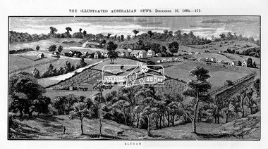
Photograph, Samuel Calvert, Eltham, The Illustrated Australian News, December 26, 1884, p212, 1884
A description in the newspaper near the illustration (page 210) reads as follows: "Eltham is a pretty little township on the Yarra Flats road, about 14 miles east north east of Melbourne, from which place there is communication by way of Heidelberg. It has a population of nearly 400 inhabitants, but in addition it is the centre of a large district extending over about 203 square miles, having a population of 2344. The land in the district is mostly used for grazing purposes, although as a rule the small farms grow a good deal of wheat, oats and other agricultural produce. A large quantity of fruit, especially raspberries and strawberries, is also produced, the rich alluvial flats along the creek upon which the township is situated being very well adapted for that purpose. Gold has also been found in the vicinity of the township, but not in remunerative quantities". This photo forms part of a collection of photographs gathered by the Shire of Eltham for their centenary project book,"Pioneers and Painters: 100 years of the Shire of Eltham" by Alan Marshall (1971). The collection of over 500 images is held in partnership between Eltham District Historical Society and Yarra Plenty Regional Library (Eltham Library) and is now formally known as 'The Shire of Eltham Pioneers Photograph Collection.' It is significant in being the first community sourced collection representing the places and people of the Shire's first one hundred years.Digital imageshire of eltham pioneers photograph collection, eltham, illustrated australian news -
 Eltham District Historical Society Inc
Photograph - Digital Photograph, Alan King, Alistair Knox Park, Eltham, 2008
Alistair Knox Park, an oasis of peace and beauty. Covered under National Trust of Australia (Victoria) Landscape Significance and Heritage Overlay, Nillumbik Planning Scheme. Published: Nillumbik Now and Then / Marguerite Marshall 2008; photographs Alan King with Marguerite Marshall.; p173 It is hard to imagine that the Alistair Knox Park, an oasis of peace and beauty beside busy Main Road, Eltham, was once the township’s rubbish dump. It was only in the 1970s that the tip was transformed into this beautiful six hectare space, which later earned it a National Trust Landscape classification. Before its life as a dump, the area was used for small farms. Thanks largely to the foresight and efforts of local environmental builder Alistair Knox, the park was designed sympathetically with the character of the wider Eltham landscape. Then, appropriately, the park was named after Knox, who was an Eltham Shire Councillor from 1971 to 1975 and Shire President in 1975. The park designers were four major forces in the urban bush landscape garden –Knox, landscape designer Gordon Ford, artist Peter Glass and landscaper Ivan Stranger. The National Trust citation for the park, originally called Eltham Town Park, includes the Eltham railway trestle bridge and the Shillinglaw Cottage. The citation states ‘the semi-natural setting of the parkland provides a landscape which is evocative of the history of the area’. Manna Gums (Eucalyptus viminalis) and Candlebarks (Eucalyptus rubida) are significant features. Most of the park’s construction was directed by Bob Grant, Superintendent of the Parks and Gardens Department for the Eltham Shire Council. First plantings occurred in Arbour Week in 1973, then the lake and botanic area were completed in 1975, with Federal Government funding, and the toilet block in 1978. Bounded by the Eltham railway line, Panther Place, Main Road, Bridge and Susan Streets, the park is in a valley about a kilometre wide overlooked by steep hills at the east and west. The Diamond Creek flows through it and the picturesque historic timber trestle railway bridge edges the north. Informal plantings of Australian indigenous and native species in open and undulating grassed settings blend with the natural landscape of the Diamond Creek to the west. The bush-style plants, particularly around the creek, balance with open lawns, paths and a cascade flowing from a small lake to another below. A footbridge over the creek leads to the park’s west. The park includes an adventure playground and barbecue areas. The park stands on part of the land bought from the Crown in 1851 by Josiah Holloway, who subdivided it into allotments and which he called Little Eltham. Most of the land was subdivided into residential lots, but the creek valley, on which the park stands, was subdivided into farm-size lots, used mainly for orchards and grazing. One of the earliest owners was John Hicks Petty, who in 1874 bought a plot from Holloway. Other families who owned properties in that area, included Rees, Clark, Waterfall, Graham, Hill and Morant. In 1901 the railway was built through the area. Jock Read, an Eltham resident since around 1920, remembers several farms in the 1920s and ’30s that occupied the site of today’s park. A poultry farm, which extended from present day Panther Place, was owned by the Gahan family. Next to that farm was another for grazing cattle owned by Jack Carrucan. Beside this was land owned by John Lyon. A doctor lived beside this, and at the north-west corner of Bridge Street and Main Road stood a memorial to the soldiers who died in World War One, which was later moved to the RSL site. Mr Read also remembers other farms and orchards west of the creek In the early 1960s the Eltham Council began buying these farms and in the late 1960s turned the areas east of the Diamond Creek into a garbage tip. When this was filled above the creek’s flood plain, the tip was moved to the west of the creek.This collection of almost 130 photos about places and people within the Shire of Nillumbik, an urban and rural municipality in Melbourne's north, contributes to an understanding of the history of the Shire. Published in 2008 immediately prior to the Black Saturday bushfires of February 7, 2009, it documents sites that were impacted, and in some cases destroyed by the fires. It includes photographs taken especially for the publication, creating a unique time capsule representing the Shire in the early 21st century. It remains the most recent comprehenesive publication devoted to the Shire's history connecting local residents to the past. nillumbik now and then (marshall-king) collection, alistair knox park, eltham -
 Eltham District Historical Society Inc
Photograph - Digital Photograph, Alan King, Blue Lake, Plenty Gorge Park, 2008
... and then European settlers. By 1837 squatters had claimed large runs of land... and then European settlers. By 1837 squatters had claimed large runs of land ...A quarry was transformed into the Blue Lake. Published: Nillumbik Now and Then / Marguerite Marshall 2008; photographs Alan King with Marguerite Marshall.; p179 The dramatic steep-sided Plenty Gorge lies along the divide of two geological areas, and separates the Nillumbik Shire and the City of Whittlesea. On the Nillumbik side are undulating hills and sedimentary rock, and in Whittlesea, lies a basalt plain formed by volcanic action up to two million years ago. This provides the Plenty Gorge Park with diverse vegetation and habitats, making it one of Greater Melbourne’s most important refuges for threatened and significant species. The park, established in 1986, consists of around 1350 hectares, and extends 11 kilometres along the Plenty River, from Greensborough to Mernda. It provides a wildlife corridor for around 500 native plant and 280 animal species. The area’s plentiful food and water attracted the Wurundjeri Aboriginal people and then European settlers. By 1837 squatters had claimed large runs of land for their sheep and cattle. The Plenty Valley was among the first in the Port Phillip District to be settled - mainly in the less heavily timbered west - and was proclaimed a settled district in 1841.But by the late 1880s, the settlers’ extensive land clearing for animal grazing, then agriculture, depleted the Wurundjeri’s traditional food sources, which helped to drive them away. Many Wurundjeri artefacts remain (now government protected), and so far 57 sites have been identified in the park, including scarred trees, burial areas and stone artefacts. Pioneer life could be very hard because of isolation, flooding, bushfires and bushrangers. Following the Black Thursday bushfires of 1851, basalt was quarried to build more fire-resistant homes. Gold discoveries in the early 1850s swelled the population, particularly around Smugglers Gully; but food production made more of an impact. In the late 1850s wheat production supplanted grazing. In the 1860s the government made small holdings available to poorer settlers. These had the greatest effect on the district, particularly in Doreen and Yarrambat, where orchards were established from the 1880s to 1914. Links with a prominent early family are the remains of Stuchbery Farm, by the river’s edge bounded by Smugglers Gully to the north and La Trobe Road, Yarrambat, to the east. The Stuchberys moved to the valley in 1890, and the family still lives in the area. In 1890, Alfred and Ada first lived in a tent where four children were born, then Alfred built the house and outbuildings around 1896. They planted an orchard, then a market garden, and developed a dairy. The family belonged to the local Methodist and tennis communities. Their grandson Walter, opened the Flying Scotsman Model Railway Museum in Yarrambat, which his widow, Vi, continues to run. Wal was also the Yarrambat CFA Captain for 22 years until 1987. Walter sold 24 hectares in 1976 for development - now Vista Court - and in 1990, the remaining 22.6 hectares for the park. Remaining are an early stone dairy and remnants of a stone barn, a pig sty and a well. Until it was destroyed by fire in 2003, a slab hut stood on the Happy Hollow Farm site, at the southern end of the park. The hut is thought to have been built in the Depression around 1893. This was a rare and late example of a slab hut with a domestic orchard close to Melbourne. Emmet Watmough and his family first occupied the hut, followed by a succession of families, until the Bell family bought it around 1948. There they led a subsistence lifestyle for 50 years, despite encroaching Melbourne suburbia. The Yellow Gum Recreation Area includes the Blue Lake, coloured turquoise at certain times of the year. Following the 1957 bushfires, this area was quarried by Reid Quarries Pty Ltd for Melbourne’s first skyscrapers, then by Boral Australia. However in the early 1970s water began seeping into the quarry forming the Blue Lake and the quarry was closed. The State Government bought the site in 1997 and opened it as a park in 1999.This collection of almost 130 photos about places and people within the Shire of Nillumbik, an urban and rural municipality in Melbourne's north, contributes to an understanding of the history of the Shire. Published in 2008 immediately prior to the Black Saturday bushfires of February 7, 2009, it documents sites that were impacted, and in some cases destroyed by the fires. It includes photographs taken especially for the publication, creating a unique time capsule representing the Shire in the early 21st century. It remains the most recent comprehenesive publication devoted to the Shire's history connecting local residents to the past. nillumbik now and then (marshall-king) collection, blue lake, plenty gorge park -
 Eltham District Historical Society Inc
Photograph - Digital Photograph, Marguerite Marshall, Stuchbery Farm dairy, 14 March 2008
... and then European settlers. By 1837 squatters had claimed large runs of land... and then European settlers. By 1837 squatters had claimed large runs of land ...Stuchbery Farm was situated on the Plenty River bounded by Smugglers Gully to the north and La trobe Road, Yarrambat, to the east. Alan and Ada Stutchbery moved to the valley in 1890, first living in a tent where four children were born. Alfred built a home and outbuildings around 1896. They planted an orchard, then a market garden and developed a dairy. Published: Nillumbik Now and Then / Marguerite Marshall 2008; photographs Alan King with Marguerite Marshall.; p179 The dramatic steep-sided Plenty Gorge lies along the divide of two geological areas, and separates the Nillumbik Shire and the City of Whittlesea. On the Nillumbik side are undulating hills and sedimentary rock, and in Whittlesea, lies a basalt plain formed by volcanic action up to two million years ago. This provides the Plenty Gorge Park with diverse vegetation and habitats, making it one of Greater Melbourne’s most important refuges for threatened and significant species. The park, established in 1986, consists of around 1350 hectares, and extends 11 kilometres along the Plenty River, from Greensborough to Mernda. It provides a wildlife corridor for around 500 native plant and 280 animal species. The area’s plentiful food and water attracted the Wurundjeri Aboriginal people and then European settlers. By 1837 squatters had claimed large runs of land for their sheep and cattle. The Plenty Valley was among the first in the Port Phillip District to be settled - mainly in the less heavily timbered west - and was proclaimed a settled district in 1841. But by the late 1880s, the settlers’ extensive land clearing for animal grazing, then agriculture, depleted the Wurundjeri’s traditional food sources, which helped to drive them away. Many Wurundjeri artefacts remain (now government protected), and so far 57 sites have been identified in the park, including scarred trees, burial areas and stone artefacts. Pioneer life could be very hard because of isolation, flooding, bushfires and bushrangers. Following the Black Thursday bushfires of 1851, basalt was quarried to build more fire-resistant homes. Gold discoveries in the early 1850s swelled the population, particularly around Smugglers Gully; but food production made more of an impact. In the late 1850s wheat production supplanted grazing. In the 1860s the government made small holdings available to poorer settlers. These had the greatest effect on the district, particularly in Doreen and Yarrambat, where orchards were established from the 1880s to 1914. Links with a prominent early family are the remains of Stuchbery Farm, by the river’s edge bounded by Smugglers Gully to the north and La Trobe Road, Yarrambat, to the east. The Stuchberys moved to the valley in 1890, and the family still lives in the area. In 1890, Alfred and Ada first lived in a tent where four children were born, then Alfred built the house and outbuildings around 1896. They planted an orchard, then a market garden, and developed a dairy. The family belonged to the local Methodist and tennis communities. Their grandson Walter, opened the Flying Scotsman Model Railway Museum in Yarrambat, which his widow, Vi, continues to run. Wal was also the Yarrambat CFA Captain for 22 years until 1987. Walter sold 24 hectares in 1976 for development - now Vista Court - and in 1990, the remaining 22.6 hectares for the park. Remaining are an early stone dairy and remnants of a stone barn, a pig sty and a well. Until it was destroyed by fire in 2003, a slab hut stood on the Happy Hollow Farm site, at the southern end of the park. The hut is thought to have been built in the Depression around 1893. This was a rare and late example of a slab hut with a domestic orchard close to Melbourne. Emmet Watmough and his family first occupied the hut, followed by a succession of families, until the Bell family bought it around 1948. There they led a subsistence lifestyle for 50 years, despite encroaching Melbourne suburbia. The Yellow Gum Recreation Area includes the Blue Lake, coloured turquoise at certain times of the year. Following the 1957 bushfires, this area was quarried by Reid Quarries Pty Ltd for Melbourne’s first skyscrapers, then by Boral Australia. However in the early 1970s water began seeping into the quarry forming the Blue Lake and the quarry was closed. The State Government bought the site in 1997 and opened it as a park in 1999.This collection of almost 130 photos about places and people within the Shire of Nillumbik, an urban and rural municipality in Melbourne's north, contributes to an understanding of the history of the Shire. Published in 2008 immediately prior to the Black Saturday bushfires of February 7, 2009, it documents sites that were impacted, and in some cases destroyed by the fires. It includes photographs taken especially for the publication, creating a unique time capsule representing the Shire in the early 21st century. It remains the most recent comprehenesive publication devoted to the Shire's history connecting local residents to the past. nillumbik now and then (marshall-king) collection, ada stuchbery, alan stuchbery, dairy, stuchbery farm, farm buildings, yarrambat, plenty gorge park -
 Kew Historical Society Inc
Photograph - Yarra Street, Kew, Ron Setford, 1960
Ron Setford and his wife Grace Setford lived in Tanner Avenue, East Kew, from c.1946 to c.1995. A keen photographer, he recorded the changing face of Kew over a 20 year period. Apart from 30 photographs of built structures and places in Kew dating from 1960 and 1961, 145 of his 35mm colour slides chronicle the development of the Eastern Freeway through the Yarra Valley over a five year period from c.1972 to c.1977. This important collection was donated to the Society by his granddaughter in 2025.This collection of 175 35mm slides is of local and statewide significance, owing to its subject matter, particularly the major development of road transport infrastructure during the 1970s with the construction of the Eastern Freeway. The photographer also took care to annotate and date most of his slides which enable the researcher to pinpoint temporal and spatial locations.Yarra Street was not made a trafficable thoroughfare until October 1956. Until then, the gully was used as a dump, a shortcut to the river, and for communal Guy Fawkes night bonfires. The open landscape in the photo reflects near-total clearing by the original estate owners for grazing livestock. Post-war homes fronting Stawell St dot the landscape. Of particular note are the Broons House (c.1952–54) by Anatol Kagan (top right), and the homes of two architects, Kurt Elsner (c.1950) (middle) and Geoffrey Danne (c.1954) (lower right). Dual carriageways made blocks accessible, but building was difficult due to steeply sloping land and complex drainage easements. Nevertheless, these challenges resulted in highly innovative designs, making Yarra Street the core of the Yarra Boulevard Heritage Precinct."Yarra St Kew"ron setford, photographs -- kew (vic.) -- 1960s, yarra street -- kew (vic.) -
 Federation University Historical Collection
Photograph, James (Jim) Smith of Happy Valley
... the property. The land was used for grazing and the two houses fell... the property. The land was used for grazing and the two houses fell ...James (Jim) Smith, (died 03/08/1974, aged 93 years) established an orchard growing snow apples near in Happy Valley after returning from mining activities in South Africa. The orchard was called "Springdallah" and was beside the Linton/Happy Valley Road across from the old Happy Valley railway station. Jim was the son of George Henry Smith (18/12/1840 - 26/11/1903) and Emma Keys Smith born Keys (07/08/1842 - 28/08/1888). George and Emma left Liverpool with other unassisted immigrants on the "Bates Family" ship with baby Clara on 08/06/1863 arriving in Melbourne on 08/06/1863. George and Emma emigrated to Australia on the invitation of Emma's brother Edward Keys who owned a property near the school at Happy Valley on which there were two houses. Teddy offered George and Emma the smaller one to live in. When "Teddy" decided to go into hotel keeping George took over the 200 acres of his property and made it a pleasant orchard and garden called "Cress Green Gardens". George had various secretarial jobs - rate collector; paymaster at the mines; until he became Shire Secretary for the Shire of Grenville, whose centre was Linton and Government Auditor for Western Victoria (1894-1903), the means of transport being horse and buggy. Another son followed his father as Shire Secretary. George and Emma had 14 children, Emma dying giving birth to Emma Keys who lived for 16 months. George later married Annie Bolte with 2 more children being born. Annie later sold the property. The land was used for grazing and the two houses fell into disrepair. In 1995 George's grandson Ernest (Alf) Alfred Watson visited the site and reported a wrought iron gate at the site and a mulberry tree near the site of his grandmother's family home. Bluestone blocks can still be seen in the paddocks from the roadside. The child in the photograph is Phyllis Joy Smith, Jim's eldest daughter. Jim Smith was the brother of Clara Emma Yung nee Smith.Sepia photo of two men and a girl. One of them is Jim Smith who established on orchard at Happy Valley. He also went to South Africa - mining activities. The orchard is now part of Clarkesdale Bird Sanctuary located at 360 Linton-Piggoreet Rd, Linton, Vic. 3360. Verso: Jim Smith South Africa (Mining) Established orchard halfway near Linton and Happy Valley. Clara Emma's brother. jim smith, james smith, clara emma smith, happy valley, yendon, piggoreet, south africa, mining, orchard, edward keys, george henry smith, emma keys smith, clara emma yung, annie bolte, shire of grenville, clarkesdale bird sanctury -
 Bendigo Historical Society Inc.
Photograph - Nell Gwynne Proposed Mine Site, 1934
Significant to mining history of Bendigo.Black and white photograph of proposed mine site of Nell Gwynne Gold Mine. Image shows vacant land with weatherboard house on left hand side of image. Gravel road in foreground, two calves grazing on side of road.Written in pencil on back of photograph in black pen: 'Nell Gwynne abt 3/11/34'nell gwynne gold mine, shaft -
 Wodonga & District Historical Society Inc
Artwork, other - Pollard's Creamery, Bonegilla Flats
George Pollard was born in Corfe, Dorsetshire England in 1824. Being dissatisfied as a clay miner, he decided to migrate to Australia. He migrated in 1851 and after a short unsuccessful time on the goldfields in Bendigo, followed by a period in Dederang and farming in Oxley, he selected land on Little River, now know as the Kiewa River in 1868. His property was know as Rosebank and George continued to live there until his death in 1915. In the early 1880s, George Pollard constructed a creamery on his property at Bonegilla Flat. The creamery stood until the late 1970s although in a state of ruin and used neaas a scratching post by the cattle which grazed in the surrounding paddock. The creamery included a chimney and fireplace. This generated warmth so that when large pans of milk were placed near the fire the cram would rise to the top and could easily be separated to produce butter for the growing family. In 1982 Fred Hillier was visiting from Queensland and offered to make the replica of the creamery featured Wodonga & District Historical Society Collection.This item is significant because it represents a creamery owned by an important family in the Bonegilla district.A small model of an old building made from clay. It includes a roof resembling corrugated iron and empty spaces for windows.Underneath Model Bonegilla Creamery 1886 By Fred Hillier 1982pollard family, agricultural buildings