Showing 2440 items
matching house construction
-
 Eltham District Historical Society Inc
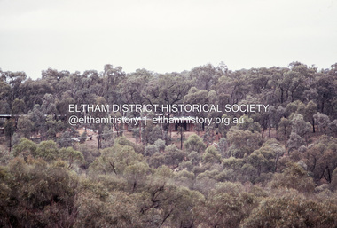
Photograph, Michael Wood, Houses on Progress Road viewed from Glen Park Road, Eltham North, February 1970, 1970
Wood family home (1969-2011) pre and post construction by Knox and Hellemons Shows Wood family home on Progress Road in centre of field of viewKodachrome 35mm colour transparency in cardboard mount Processing date FEB70M6Inscribed in ink "Hoses on Progress Rd from Glen Park Rd, Eltham North 1970"alistair knox design, eltham north, hellemon, houses, progress road, glen park road -
 Eltham District Historical Society Inc
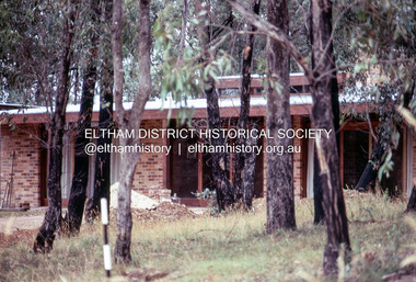
Photograph, Michael Wood, Wood family home post construction, 184 Progress Road, Eltham North, February 1970, 1970
Wood family home (1969-2011) pre and post construction by Knox and HellemonsKodachrome 35mm colour transparency in cardboard mount Processing date FEB70M6Inscribed in ink "184 Progress Rd Eltham North 1970"alistair knox design, eltham north, hellemon, houses, progress road -
 Eltham District Historical Society Inc
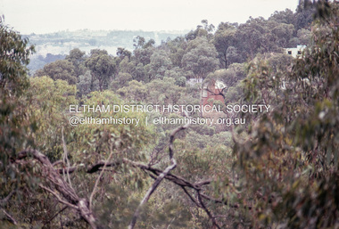
Photograph, Michael Wood, View south from 184 Progress Road to houses on Scenic Crescent, Eltham North, February 1970, 1970
Wood family home (1969-2011) pre and post construction by Knox and HellemonsKodachrome 35mm colour transparency in cardboard mount Processing date FEB70M6Inscribed in ink "View south from 184 Progress to Scenic Crescent, Eltham North 1970"alistair knox design, eltham north, hellemon, houses, progress road, scenic crescent -
 Eltham District Historical Society Inc
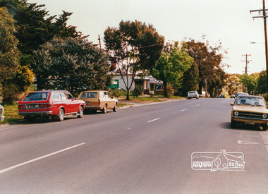
Photograph, Looking west near 942 Main Road, Hurstbridge, c. Oct 1987, 1987
Yvonne's Dressmaking and Alteration Service at 942 Main Road. Formerly a bakery, the building was demolished in 1990 and is now the site of Hurstbridge Saddlery. The milkbar is down the road, brick wall with a blue sign on it. There's still an older house next to the milkbar, but that's hidden from view in this shot as it's further back from the road. Date based on other similar display panels visible in images of the Shire of Eltham display at the Eltham Community Festival, 7 November 1987. Shire of Eltham Engineering Department Providing the resources to undertake • Survey, design, consultation • Road construction and maintenance • Bridge construction and maintenance • Street sweeping • Drain and pit cleaning • Traffic engineering installation and maintenance • Garbage collection • Tip management, land reclamation and beautification • Maintenance of community buildings • Provision of community and recreation facilitiesPhoto print mounted on carddisplay panel, eltham festival, heidelberg-kinglake road, hurstbridge, hurstbridge milk bar, infrastructure, main road, mm, shire of eltham, yvonne's dressmaking and alteration service -
 Eltham District Historical Society Inc
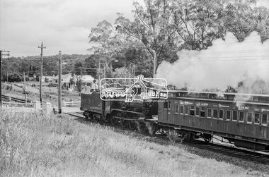
Photograph, Steam locomotive D-639 Vintage train excursion bound for Eltham at the Wattletree Road level crossing, Eltham, c.1970, 1970
Possibly run in conjunction with the Eltham Community Festival or the Hurstbridge Wattle Festival; the steam train would conduct trips between Eltham and Hurstbridge Railway stations. As there is no turning table at Hurstbridge, the locomotive would simply shunt from one end of the carriages to the other to reverse direction, hence the locomotive is running in reverse as it approaches Eltham Station. The first house in the background on Railway Parade, Number 97, remains as of 2019. The next house, Number 95 has been demolised since April 2018 and new construction in place.Digital TIFF file Scan of 35mm Ilford HP4 black and white transparencyd-639, eltham festival, george coop collection, hurstbridge wattle festival, level crossing, passenger carriage 19bc, railway parade, steam engine, vintage train excursion, wattletree road -
 Eltham District Historical Society Inc
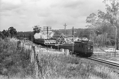
Photograph, Steam locomotive D-639 Vintage train excursion bound for Eltham at the Wattletree Road level crossing, Eltham, c.1970, 1970
Possibly run in conjunction with the Eltham Community Festival or the Hurstbridge Wattle Festival; the steam train would conduct trips between Eltham and Hurstbridge Railway stations. As there is no turning table at Hurstbridge, the locomotive would simply shunt from one end of the carriages to the other to reverse direction, hence the locomotive is running in reverse as it approaches Eltham Station. The first house in the background on Railway Parade, Number 97, remains as of 2019. The next house, Number 95 has been demolised since April 2018 and new construction in place.Digital TIFF file Scan of 35mm Ilford HP4 black and white transparencyd-639, eltham festival, george coop collection, hurstbridge wattle festival, level crossing, passenger carriage 19bc, railway parade, steam engine, vintage train excursion, wattletree road -
 Eltham District Historical Society Inc
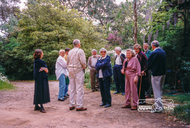
Photograph, Peter Bassett-Smith, Eltham Mud Brick Heritage Excursion, 4 October 1998, 04/10/1998
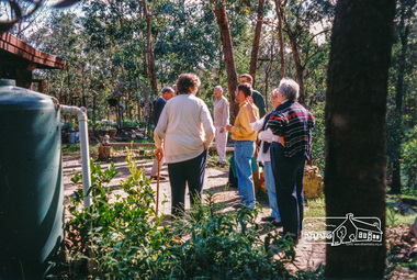
[article in EDHS Newsletter No. 123, November 1998:] MUD BRICK HERITAGE EXCURSION AND THE FUTURE. A small group of members attended the excursion on 4th October. We visited a number of earth houses listed by the Eltham Heritage Study in a very pleasant day's outing. The first visit was to the home of Jenny and Brian Ellis in York Street, formerly the home of Jenny's father Professor William McMahon Ball. We were made very welcome with inspection of the inside and outside showing the various stages of construction. We then walked through the grounds of "Kinloch", the Jelbart property in Arthur Street where we saw their large mud brick house and barn. Lunch was at Marion and Russell Yeoman's house in Peter Street. This pise house was built by the Moore family in the early 1950's. In the afternoon we visited the home of artist Jenni Mitchell in Fordhams Road, one of the last examples of the work of Alistair Knox. Then we travelled to Laughing Waters Road where we saw two interesting houses owned and built by well known landscape gardener Gordon Ford. Along the way we stopped to view a number of other properties from the street.Colour photographactivities, eltham, heritage excursion, mud brick -
 Eltham District Historical Society Inc
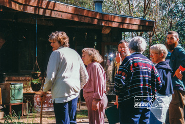
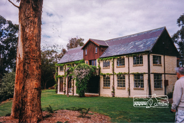
Photograph, Peter Bassett-Smith, Boomerang House, Laughing Waters Road, Eltham; Eltham Mud Brick Heritage Excursion, 4 October 1998, 04/10/1998
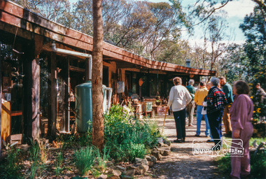
[article in EDHS Newsletter No. 123, November 1998:] MUD BRICK HERITAGE EXCURSION AND THE FUTURE. A small group of members attended the excursion on 4th October. We visited a number of earth houses listed by the Eltham Heritage Study in a very pleasant day's outing. The first visit was to the home of Jenny and Brian Ellis in York Street, formerly the home of Jenny's father Professor William McMahon Ball. We were made very welcome with inspection of the inside and outside showing the various stages of construction. We then walked through the grounds of "Kinloch", the Jelbart property in Arthur Street where we saw their large mud brick house and barn. Lunch was at Marion and Russell Yeoman's house in Peter Street. This pise house was built by the Moore family in the early 1950's. In the afternoon we visited the home of artist Jenni Mitchell in Fordhams Road, one of the last examples of the work of Alistair Knox. Then we travelled to Laughing Waters Road where we saw two interesting houses owned and built by well known landscape gardener Gordon Ford. Along the way we stopped to view a number of other properties from the street.Colour photographactivities, eltham, heritage excursion, mud brick, boomerang house, laughing waters road -
 Eltham District Historical Society Inc
Photograph, Peter Bassett-Smith, Boomerang House, Laughing Waters Road, Eltham; Eltham Mud Brick Heritage Excursion, 4 October 1998, 04/10/1998
[article in EDHS Newsletter No. 123, November 1998:] MUD BRICK HERITAGE EXCURSION AND THE FUTURE. A small group of members attended the excursion on 4th October. We visited a number of earth houses listed by the Eltham Heritage Study in a very pleasant day's outing. The first visit was to the home of Jenny and Brian Ellis in York Street, formerly the home of Jenny's father Professor William McMahon Ball. We were made very welcome with inspection of the inside and outside showing the various stages of construction. We then walked through the grounds of "Kinloch", the Jelbart property in Arthur Street where we saw their large mud brick house and barn. Lunch was at Marion and Russell Yeoman's house in Peter Street. This pise house was built by the Moore family in the early 1950's. In the afternoon we visited the home of artist Jenni Mitchell in Fordhams Road, one of the last examples of the work of Alistair Knox. Then we travelled to Laughing Waters Road where we saw two interesting houses owned and built by well known landscape gardener Gordon Ford. Along the way we stopped to view a number of other properties from the street.Colour photographactivities, eltham, heritage excursion, mud brick, boomerang house, laughing waters road -
 Eltham District Historical Society Inc
Photograph, Peter Bassett-Smith, Rocknall, 25 Diamond Street, Eltham; Eltham Mud Brick Heritage Excursion, 4 October 1998, 04/10/1998
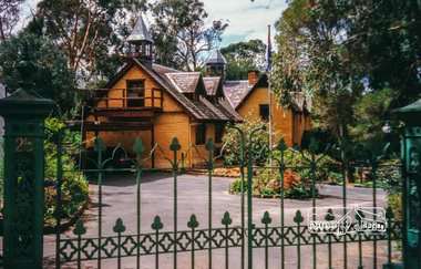
[article in EDHS Newsletter No. 123, November 1998:] MUD BRICK HERITAGE EXCURSION AND THE FUTURE. A small group of members attended the excursion on 4th October. We visited a number of earth houses listed by the Eltham Heritage Study in a very pleasant day's outing. The first visit was to the home of Jenny and Brian Ellis in York Street, formerly the home of Jenny's father Professor William McMahon Ball. We were made very welcome with inspection of the inside and outside showing the various stages of construction. We then walked through the grounds of "Kinloch", the Jelbart property in Arthur Street where we saw their large mud brick house and barn. Lunch was at Marion and Russell Yeoman's house in Peter Street. This pise house was built by the Moore family in the early 1950's. In the afternoon we visited the home of artist Jenni Mitchell in Fordhams Road, one of the last examples of the work of Alistair Knox. Then we travelled to Laughing Waters Road where we saw two interesting houses owned and built by well known landscape gardener Gordon Ford. Along the way we stopped to view a number of other properties from the street.Colour photographactivities, eltham, heritage excursion, mud brick, diamond street, rocknall -
 Eltham District Historical Society Inc
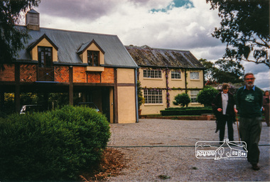
Photograph, Peter Bassett-Smith, Jelbart property, Arthur Street, Eltham Mud Brick Heritage Excursion, 4 October 1998, 04/10/1998
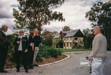
[article in EDHS Newsletter No. 123, November 1998:] MUD BRICK HERITAGE EXCURSION AND THE FUTURE. A small group of members attended the excursion on 4th October. We visited a number of earth houses listed by the Eltham Heritage Study in a very pleasant day's outing. The first visit was to the home of Jenny and Brian Ellis in York Street, formerly the home of Jenny's father Professor William McMahon Ball. We were made very welcome with inspection of the inside and outside showing the various stages of construction. We then walked through the grounds of "Kinloch", the Jelbart property in Arthur Street where we saw their large mud brick house and barn. Lunch was at Marion and Russell Yeoman's house in Peter Street. This pise house was built by the Moore family in the early 1950's. In the afternoon we visited the home of artist Jenni Mitchell in Fordhams Road, one of the last examples of the work of Alistair Knox. Then we travelled to Laughing Waters Road where we saw two interesting houses owned and built by well known landscape gardener Gordon Ford. Along the way we stopped to view a number of other properties from the street.Colour photographactivities, eltham, heritage excursion, mud brick, arthur street, jelbart property -
 Eltham District Historical Society Inc
Photograph, Peter Bassett-Smith, Jelbart property, Arthur Street, Eltham Mud Brick Heritage Excursion, 4 October 1998, 04/10/1998
[article in EDHS Newsletter No. 123, November 1998:] MUD BRICK HERITAGE EXCURSION AND THE FUTURE. A small group of members attended the excursion on 4th October. We visited a number of earth houses listed by the Eltham Heritage Study in a very pleasant day's outing. The first visit was to the home of Jenny and Brian Ellis in York Street, formerly the home of Jenny's father Professor William McMahon Ball. We were made very welcome with inspection of the inside and outside showing the various stages of construction. We then walked through the grounds of "Kinloch", the Jelbart property in Arthur Street where we saw their large mud brick house and barn. Lunch was at Marion and Russell Yeoman's house in Peter Street. This pise house was built by the Moore family in the early 1950's. In the afternoon we visited the home of artist Jenni Mitchell in Fordhams Road, one of the last examples of the work of Alistair Knox. Then we travelled to Laughing Waters Road where we saw two interesting houses owned and built by well known landscape gardener Gordon Ford. Along the way we stopped to view a number of other properties from the street.Colour photographactivities, eltham, heritage excursion, mud brick, arthur street, jelbart property -
 Eltham District Historical Society Inc
Photograph, Peter Bassett-Smith, Cottage, Main Road, Eltham, Eltham Mud Brick Heritage Excursion, 4 October 1998, 04/10/1998
[article in EDHS Newsletter No. 123, November 1998:] MUD BRICK HERITAGE EXCURSION AND THE FUTURE. A small group of members attended the excursion on 4th October. We visited a number of earth houses listed by the Eltham Heritage Study in a very pleasant day's outing. The first visit was to the home of Jenny and Brian Ellis in York Street, formerly the home of Jenny's father Professor William McMahon Ball. We were made very welcome with inspection of the inside and outside showing the various stages of construction. We then walked through the grounds of "Kinloch", the Jelbart property in Arthur Street where we saw their large mud brick house and barn. Lunch was at Marion and Russell Yeoman's house in Peter Street. This pise house was built by the Moore family in the early 1950's. In the afternoon we visited the home of artist Jenni Mitchell in Fordhams Road, one of the last examples of the work of Alistair Knox. Then we travelled to Laughing Waters Road where we saw two interesting houses owned and built by well known landscape gardener Gordon Ford. Along the way we stopped to view a number of other properties from the street.Colour photographactivities, eltham, heritage excursion, mud brick, main road -
 Eltham District Historical Society Inc
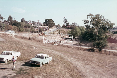
Photograph, Main Road widening, Eltham, c.March 1968, 1968
... duplication, Eltham, Eltham Shire Office, Gahan House, Main..., Eltham Shire Office, Gahan House, Main Road, Road construction ...Immediately prior to duplication of Main Road. Gahan house on left and Shire Offices in background35mm Colour positive transparency Mount - Agfacolor Service (Blue stepped)duplication, eltham, eltham shire office, gahan house, main road, road construction -
 Eltham District Historical Society Inc
Photograph, Main Road widening, Eltham, c.March 1968, 1968
... duplication, gahan house, main road, road construction... melbourne Duplication of Main Road. Gahan House almost completely ...Duplication of Main Road. Gahan House almost completely demolished. Shillinglaw Cottage on right.35mm Colour positive transparency Mount - Agfacolor Service (Blue stepped)duplication, gahan house, main road, road construction, shillinglaw cottage -
 Eltham District Historical Society Inc
Document - Folder, Cr. John Herbert, Shire President, Eltham Shire, 1894-1906, 1898 to 1917
Cr. John Herbert served three terms as Eltham Shire President A3 photocopy of 3 documents with note at bottom of page - Cr. John Herbert 1. Federal Convention, The Government of Victoria request the honor of the Company of the The President, Eltham Shire & Lady to a Garden Party at Parliament House Melbourne on Friday February 4th 1898 at 3 o'clock. 2. Heidelberg & Eltham Railway Construction Trust, Ticket No. 87, Dinner in celebration of the opening of the Railway to Eltham, will be given in the Marquee on the Station Ground, Eltham on Thursday, 5th June, 190212.30 o'clock, H.J. Price, Secretary 3. Post card addressed to Miss Flora Herbert, "Blair Athol", Nutfield P.O., Victoria, Australia - France 12/12/17 - Dear Floss, Just a card to let you know I have not forgotten you. Tell "Mum" I am quite well, but a bit cold, I remain yours sincerely, Will"Photocopy A3 page; all three items on one page aif, blair athol, councillors, cr. john herbert, eltham railway station, eltham shire council, federal convention, first world war, flora herbert, government of victoria, heidelberg & eltham railway construction trust, invitation, nutfield, opening ceremony, parliament house, postcards, shire president -
 Eltham District Historical Society Inc
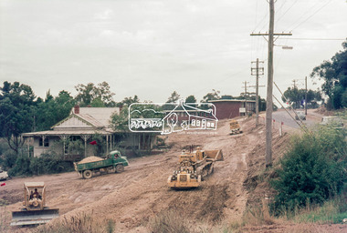
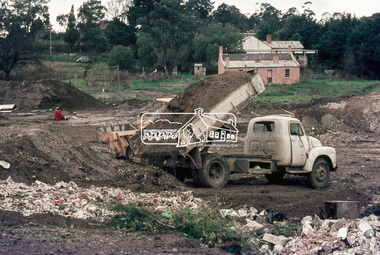
Photograph, Start of works, Eltham Tip Reclamation, Main Road, Eltham, 1 August 1967, 1967
Possibly 7 August 1967. Commencement of the reclamation of Eltham tip to be converted into Eltham Town Park. Note relocated Shillinglaw cottage in front of old Gahan house in background.35mm colour positive transparency blue Agfacolour Service plastic mountalistair knox park, construction, eltham tip, eltham town park, main road -
 Eltham District Historical Society Inc
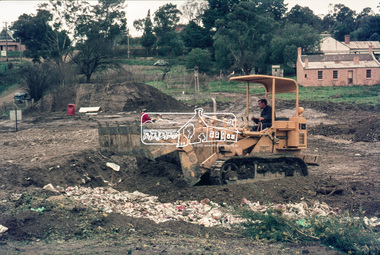
Photograph, Start of works, Eltham Tip Reclamation, Main Road, Eltham, 1 August 1967, 1967
Possibly 7 August 1967. Commencement of the reclamation of Eltham tip to be converted into Eltham Town Park. Note relocated Shillinglaw cottage in front of old Gahan house in background.35mm colour positive transparency blue Agfacolour Service plastic mountalistair knox park, construction, eltham tip, eltham town park, main road -
 Bendigo Military Museum
Photograph - New Printing Building foundation preparation, Lithographic Squadron - Army Survey Regiment, Fortuna, Bendigo, 1987
This is a set of 18 photographs of contractors preparing the foundations for the construction of Lithographic Squadron’s new Printing Building at Fortuna, Bendigo on the 2nd of October 1987. The building was purpose built to house a new computer-controlled Heidelberg Speedmaster 102 five colour lithographic offset Printing Press. The print room was named Wayzgoose Hall after a medieval printing house festival. Wayzgoose Hall and the Speedmaster Press printing capability was commissioned by the Commander of the 3rd Military District BRIG P. Davies AM, ADC on Wednesday 27th June 1990. This occasion is covered in more detail in page 145 of Valerie Lovejoy’s book 'Mapmakers of Fortuna – A history of the Army Survey Regiment’ ISBN: 0-646-42120-4.This is a set of 18 photograph of the foundations being prepared for Lithographic Squadron’s new Printing Building, Army Survey Regiment at Fortuna, Bendigo, 2nd October 1987. Black and white photos .1P to .4P are on photographic paper and scanned at 300 dpi. Photographs .5P to.18P are on 35mm negative film and scanned at 96 dpi. They are part of the Army Survey Regiment’s Collection. .1) to .9) - Photo, black & white, 1987. Foundations preparation. .10) - Photo, black & white, 1987. Foundations preparation, Paul Baker. .11) - Photo, black & white, 1987. Foundations preparation, Gary Kerr .12) to .17) - Photo, black & white, 1987. Foundations preparation. .18) - Photo, black & white, 1987. Foundations preparation, Gary Kerr No personnel are identified. Annotated with date on negative sleeve.royal australian survey corps, rasvy, army survey regiment, army svy regt, fortuna, asr, litho, printing -
 Federation University Historical Collection
Pamphlet, Jeff Zilles, Old Curiosity Shop, c1980s
... is significant? Construction of the house later known as the Old... Curiosity Shop was q house was built by bricklayer James Warwick ...The Old Curiosity Shop was q house was built by bricklayer James Warwick, and his wife Caroline, with construction beginning around 1863. It was opened to the public in 1895. What is significant? Construction of the house later known as the Old Curiosity Shop commenced about 1863, the year bricklayer, James Warwick obtained a miner's right for a residential block on the edge of the exhausted Eureka diggings in the newly proclaimed municipality of Ballarat East. James built a modest 4-roomed timber and brick house for his expanding family and continued in the bricklaying trade until retiring around the early 1880s. By then he was pursuing his gardening interests in the local Horticultural Society and was supervising the gardens of many East Ballarat residents. It was during these years that his gardening and building interests converged to find expression in the marvellous permutations of decoration that extend over the house and garden. Using cast-off crockery, glass, ceramic figurine and mirror shards, shells, wallpaper samples, architectural ornament and slag, a place was found for all manner of things, large and small. Children would bring broken china dolls and bits of crockery, and the patient mosaic work preoccupied James and his wife Caroline for the rest of their lives. The work has its origins in the grottoes and shellhouses that ornamented the gardens of large English estates from the 1730s. In the few years before James' death in 1898, the house had become known as the 'Old Curiosity Shop', inspiring associations with the Charles Dickens novel of the same name. By then professional photographs had also been taken and thousands of tourists were visiting it yearly. Caroline obtained copyright for 2 of the photos and began issuing her own postcards before she died in 1903. The Shop passed to their son Charles and then to a succession of owners who added their own mythology to the story of the Warwicks and their work. After attracting tourists for more than 100 years, the Shop closed to the public in 1999. (Vitorian Heritage Database)Brochures on the Old Curiosity Shopold curiosity shop, warwick, ballarat east, james warwick, caroline warwick -
 Flagstaff Hill Maritime Museum and Village
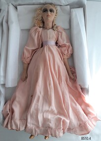
Leisure object - Boudoir Doll, c. early 1900s
The donor was given this doll about 50 years ago by her grandfather (in the late 1960s). He used to be a handyman at a high rise building in St Kilda, Melbourne. He had been doing some work for one of the old ladies and she gave him the doll to give to his granddaughter, who collected dolls. The doll has spent a few years at the Nagambie museum until it closed down and returned to the donor The origins or age of the doll are unknown. Originally it was thought to be a Fashion Doll dating from around the 1880s but the painted face together with the bisque legs and gold painted shoes are similar to those found on Boudoir Dolls (also known as Bed Dolls, Sofa Dolls, Flapper Dolls and French Dolls) of the early 20th century. Fashion dolls were sent from fashion houses to advertise the latest styles, fabrics, trims, hairstyles and accessories. Dressmakers would show these dolls to their customers. Ladies would then place their order and the dressmakers would make the dress to their size. The dressmakers would learn the construction techniques from examining the dolls. Boudoir Dolls dolls usually had no maker's marks and were primarily used as bedroom decorations for ladies rather than as children's toys. This doll appears to date at about the early part of the 20th century, but the petticoats are much older - possibly from a child's christening gown. At the time that the donor received the doll, it had a coloured lace over-gown that was badly torn so her mother removed it to replace with more lace but this never eventuated. The pink silk dress also appears to have been remodelled into a 19th century style with gathered sleeves and a gathered skirt. This fashion or boudoir doll is significant for being a rare example of a doll made in the late 19th or early 20th centuries. The doll is wearing clothing representing the fashion for young girls in that era. The doll is also significant as an item possibly used by fashion houses and dressmakers to advertise the latest fashions in clothing, trims, accessories and hairstyles. A doll such as this may have been found in a Victorian dressmaker's premises for use as a pattern and technique template and for a display to customers. It may also have been used as a decorative item in a lady's bedroom.Female boudoir doll with silk face and body, and porcelain lower arms and legs. She has plaited blonde silk hair. Her painted face has brown eyes and her shoes are painted gold. The doll is dressed in a long pink puffed-sleeve dress with a gathered waist and a ruffle at the hem. A pink ribbon around her waist is tied at the back. There are small silver balls hand-stitched around the neckline. She has a white, hand-embroidered lace petticoat and bloomers.warrnambool, flagstaff hill maritime museum, shipwreck coast, flagstaff hill maritime village, great ocean road, doll, boudoir doll, female doll, dressmaker's doll, display doll, late 1800s doll, fashion doll, antique doll, 19th century doll, children's fashion, girl's fashion, late 1800s children's fashion, early 20th century doll, composite doll, french doll -
 Flagstaff Hill Maritime Museum and Village
Functional object - Lamp Light, late 19th - early-20th century
This gas lamp light and stand came from the original manufacturer in Melbourne. Gas street lights such as this one were used in Melbourne from the mid-19th century. The lights enabled safer after-dark travel for pedestrians and vehicles and were a deterrent to crime. A lamp lighter was employed to keep the lamps lit, sometimes with little success due to weather conditions and the pranks of youths. WARRNAMBOOL Gasworks In Warrnambool prior to 1874 there were about twenty rare, individually lit street lights in Warrnambool, each with its own supply of kerosene. These lamps were in the central business area of Timor, Koroit and Liebig Streets. The Warrnambool Gas Company Ltd. was registered as an incorporated company in 1873. It was a private, locally owned business. It was located at 209-215 Merri Street, Warrnambool, on the land, which is just west of the later-built railway station. The first managers of the Gas Company lived in a substantial stone house on site, but later the managers lived in a residence in Henna Street between Merri and Timor Streets. The original home, which still stands, became a residence for the Railway Station Master from about 1890. In August 1874 the construction of the gasworks was complete and at the end of that month gas was supplied to all of the existing lamps in Warrnambool for the first time. The Warrnambool Gas Company wound up in 1880-1881 and was purchased by the Warrnambool Borough Council with money raised by a loan – the Borough’s first ‘loan transaction’. The Council established a piped network to supply gas to other street connections. The gasworks were privatised and upgraded in 1952. In 1972 the town supply was converted to liquid petroleum gas and by the early 1980s the gasworks were closed down. In 1986 Warrnambool was supplied with natural gas from a site near Port Campbell. The Warrnambool gasworks supplied all street and shop lighting and most domestic lighting until 1923 when electricity was available for lighting. Bromfield Street in Warrnambool was named after the director of the gasworks, James Astley Bromfield (1823-1903). He arrived in Warrnambool from Worcestershire, England, in 1852 and was very active in the local council and community. Cockman Street was named after the first secretary of the gasworks in 1874, Walter Cockman (c.1821-1892). He was a Mayor and businessman. The second Manager, Luther Rodgers, worked for the gas company for about twenty years and both Rodger Place and Rodgers Road in Warrnambool have been named after him. LAMP LIGHTS IN MELBOURNE In the 1820s Melbourne's innkeepers were legally required to have a lamp light outside their premises from sunset to sunrise. This was the first instance of street lamps being used in Melbourne. In 1847 the first oil lamp was used in the city. In 1849 a gas lamp was installed on the Swanston Street Bridge and much of the city had oil lamps installed by then. In August 1857 the installation of street gas lamps began in Melbourne. They were welcomed for the much brighter illumination they gave. By 1860 there were 414 lamp pillars. The phrase was quoted often - "A light was as good as a policeman". The first gas burners used for street lighting were called 'fishtail' gas burners. These were replaced in the early 1900s by gas mantles. The City of Melbourne Gas Coke Company was formed in 1850 but due to the Gold Rush the manufacture and distribution of the gas supply was delayed until January 1856. By the 1890s the gas supplying the lights was supplied by three companies in Melbourne. In 1879 a football match was played at the MCG under electric lighting and gradually electric arc lights were installed inside and outside buildings in the city. Lamp lights such as the one in Flagstaff Hill’s collection were no longer needed. (References: John Lindsay re Lamp Light history 2019-01-29, Former Warrnambool Gas Company Limited, Victorian Heritage Database Report, Heritage Number 149746 https://vhd.heritagecouncil.vic.gov.au/places/149746/download-report ) The lamp light is representative of the lamps used in Melbourne from the mid-nineteenth century to light the streets at night and make Melbourne a safer city. The lamp is also representative of the gas street lighting in Warrnambool from the mid-1870s-1920s.Lamp light or gas light. Street light, one of the last gas street lights removed from Melbourne. (Reconditioned by Friends of Flagstaff Hill, 2013)flagstaff hill, warrnambool, shipwrecked coast, flagstaff hill maritime museum, maritime museum, shipwreck coast, flagstaff hill maritime village, great ocean road, lamp light, gas light, gas lamp, street lamp, street light, gas street light, melbourne street lighting, warrnambool street lighting, melbourne gas street light, warrnambool gas company, warrnambool gasworks, james bromfield, walter cockman, luther rodgers, city of melbourne gas coke company -
Mission to Seafarers Victoria
Photograph - Reproduction, Jay Miller, 6 June 2019
This photograph was published in the Geelong Advertiser on Friday 23 November 1906, page 4 with this article: "Owing to the generosity of an anonymous donor, the Victorian Missions to Seamen has been supplied with a long felt want in the shape of a modern motor launch to facilitate and render more efficient the work among the vessels in the Yarra and Hobson's Bay. The order for the construction of the boat, was placed with Mr. Chas. Blunt, of the Eastern Beach, and complimentary references were made to her graceful line- as she rode in light .trim after the launching on Wednesday afternoon. She is 31ft. long. Oft. beam, and has a depth of 3ft. The frame is of jarrah and ben* blackwood. and inch kauri planking has been used in building Iter. A neat deck-house with Oft. headroom is situat ed-umidsliip*. and a short mast is pro vided to carry the well-known blue flag of the -.fission. The launch motors will develop a speed of between nine and ten miles an hour: The finishing touches have yet to be given her. and she will afterwards be row«l to have her engines fitted in. -The launch will he ready for service for the busy wheat season com mencing at- the end of the year. The launching ceremony took place at 6 p.m. on Wednesday at the builder's yards, in the .presence of njarge gather ing of spectators. The Archdeacon of Geelong. the Rev. O. P. C'ros-.ley. ecu ducted a short dedication service, and the other clergymen who took part in the service were the Primate of Aus tralia. the Right Rev. Dr. Sauiuarcz Smith: the Rev. A. Giirney Goldsmith, the Missions chaplain: and the Rev. H. Kelly. The Bishop of Newcastle, Dr. Stretch, and the chaplain of the New castle Mission, the Rev. AYnddy. and Canon Nash were also present. The Primpte. addressing the gar boring as "My good friends of Geelong." said be had never been in sight of the hay before. bill had'gladly accepted the in vitation to say a few words in connec tion with the dedication of tiro launch. He had always been interested in mis sions of all sorts, as they ali as Christian men and women 110 doubt- were, and lie was particularly interested in Missions to Seamen, because in the Society at' borne, with which this Society was con nected, he had a son-in-law who was mission chaplain in the Medway. He therefore know something about a launch for the purpose of a mission like this, and also knew 'something about missions to seamen. In Sydney for some time past it had been doing good work—work which he was sure they would all feel was of the widest possible value. This year he was at the annual meeting of the Missions to Seamen in London presided over by the Bishop o-f Stcphney. -He (the Primate) at that meeting remarked that the Mission in it, value was personal, local and Im perial. It was of personal value to thee who came under the ministra tions of the church, and in the social as pect : it was local because where the Mission existed the feelings of the lo cality were thrown out. in sympathy with j tlie -Mission, and the people themselves thus benefited. It was also a matter of Imperial interest because it- was really i a world-wide Mission, inasmuch as the | sailors as they" went from one part of the world to another were in themselves j missionaries either for evil or for good, i Thev might he missionaries with a mcs i sago which might degrade and "work ail I evil influence amongst, men, and with i conduct which might reflect a reproach !' upon Christian profession. On the other hand, they might be Chrisian men endeavoring more and more to show the .example of the Christian life in the J midst of very big difficulties and tempta tions. • -Ho came to show liis sympathy with tlio appropriately-named '"'Southern Cross," and from what lie had boon told he believed she was a good boat, a good gift, and launched for a good purpose. They should be thankful that it was a good boat and .thankful because it was a good gift by an anonymous donor, whom he congratulated on doing such a useful thing." The idea of the launch ing ceremony was to ask the blessing of God because ".Except the Lord hless'the house their labor is hut lost'that build it." The Archdeacon expressed thanks to the Primate for attending the cere mony, and regretted that the Arch bishop was unable to attend. They dc- | sired that the boat- should always be as sociated with the.Church Congress 1906. I The opening hymn was "For those in j peril on the sea," followed hv Psalm I 107, "'They'that, go down to the sea in 1 Ships." Tlio prayers included an ap peal foiUDirine blessing on .the launch, and for tho preservation of those who may travel in her. ' Xlio Benediction was pronounced by the Primate, and the christening cere mony performed by Hiss Connibere. From the bow there was suspended a bottle of pure water covered with red, white and blue streamers and roses. Dashing the bottle in,fragments against the launch's bow. Miss Connibere named her the "Southern Cross." Cheers were given for the launch/and as she travell ed down the slip further cheers were given. She carried the Mission flag at tho masthead, and between Union Jacks at tho bow and stern, a long string of flags fluttered gaily* in the breeze. The collection was in aid of the Mis sions to Seamen and the Geelong Sailors' Rest.Reproduction of a photograph from a newspaper.Fujifilm / Quality Dry Photo papersouthern cross, motor boat, mission to seamen, seamen's mission, charles blunt, blunt boatbuilders, geelong -
Glenelg Shire Council Cultural Collection
Slide - Slide - Construction of Portland Cashmore Airport, 1980s
Port of Portland Authority -
Glenelg Shire Council Cultural Collection
Photograph - Photograph - Aerial view of CSR Softwoods plant, Portland, c. 1974
Port of Portland CollectionFront: (no inscriptions) Back: (no inscriptions)port of portland archives, aerial photography, portland harbour -
Glenelg Shire Council Cultural Collection
Plaque, Bronze Plaque, 1950s
Port of Portland CollectionBronze Plaque. Inscribed.Front: 'Portland Harbour Trust Commissioners, 1950' 'The construction of Portland Harbour commenced at this point November 1952'. Back: - -
Glenelg Shire Council Cultural Collection
Plaque, n.d
Port of Portland CollectionBronze plaqueFront: 'The construction of Portland Harbour commenced at this point November 1952'. verso- 'Portland Harbour Trust Commissioners, 1950'port of portland