Showing 1133 items matching "kew east"
-
 Melbourne Tram Museum
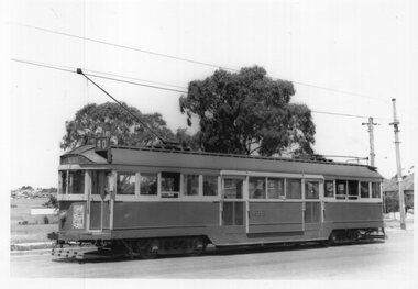
Photograph - Black & White Photograph/s, Keith Kings, 16/02/1957 12:00:00 AM
... East Kew... Bennett's Pde, East Kew 16/2/1957, by Keith Kings. Tram has..., East Kew 16/2/1957" and KSK number "V(k)(6)".... Trams tramways East Kew SW2 class Route 40 tram 436 On rear ...Black and White Photograph of SW2 436, High St cnr Bennett's Pde, East Kew 16/2/1957, by Keith Kings. Tram has destination of Spencer St, route 40.On rear in ink "M&MTB SW2 436, High St cnr Bennetts Pde, East Kew 16/2/1957" and KSK number "V(k)(6)".trams, tramways, east kew, sw2 class, route 40, tram 436 -
 Kew Historical Society Inc
Plan - Subdivision Plan, Jas R Mathers Son & McMillan, Eastlawn Estate : East Kew Auction Sale, 1914
... Eastlawn Estate : East Kew Auction Sale... pleasant Suburb than East Kew for the busy business man. When... pleasant Suburb than East Kew for the busy business man. When ...The Kew Historical Society's map collection includes a substantial number of real estate subdivision plans, mainly of Kew but also of surrounding suburbs in Melbourne. Most of the subdivision plans date from the 1920s and 1930s when the districts old homes and local farmland were being split up to accommodate residential growth in the postwar period. These early plans were assembled by a local firm, Jas R Mather & McMillan, which had an office in Cotham Road. Many of the plans, and sometimes photos, were annotated by the agents.Subdivision plans are historically important documents used as evidence for the growth of suburbs in Australia. They frequently provide information about when the land was sold as well as evidence relating to surveyors and real estate and financial agents. The numerous subdivision plans in the Kew Historical Society's collection represent working documents, ranging from the initial sketches made in planning a subdivision to printed plans on which auctioneers or agents listed the prices for which individual lots were sold. In a number of cases, the reverse of a subdivision plan in the collection includes a photograph of a house that was also for sale by the agent. These photographs provide significant heritage information relating house design and decoration, fencing and household gardens.The photograph may also be aesthetically significant depending on the importance of the photographic atelier.The ‘Eastlawn Estate’ was surveyed and ready for auction in March 1914, three months before the outbreak of World War I. Sixty-six allotments, created on the ‘order of Mr & Miss Preston’ surrounded the mansion of Woodlands in Harp Road. Woodlands formed part of the Estate, being advertised as lot 1. The allotments faced High, Station and Wright Streets, Harp and Normanby Roads, and Woodlands Avenue. Pru Sanderson in the Kew Conservation Study (Vol.2, 1988) wrote that the Eastlawn Estate ‘covered the western half of the failed Harp of Erin Estate’. Contemporary advertisements promoted the Eastlawn Estate as: ‘There will be no more convenient district nor pleasant Suburb than East Kew for the busy business man. When the Electric Tram is laid, he will be able to journey quickly and pleasantly direct from Collins Street to his home in the Eastlawn Estate in about 20 minutes’. The actual plans of subdivision were included in advertisements in The Argus and in the local newspapers."C" top left. Various annotations.subdivision plans - kew, station street, normanby road, high street, woodlands avenue, harp road, woodlands - kew -
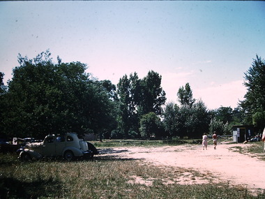
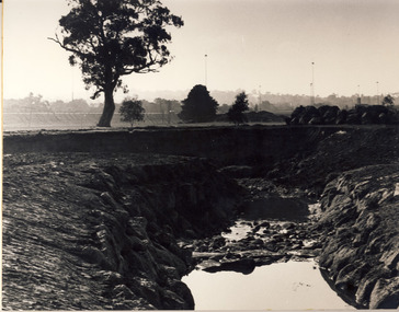
![Photograph - Construction of the F19 [Eastern Freeway], Ron Setford, 1971](/media/collectors/550653872162f11fb04854aa/items/67cbd1c0494c4da380441bb3/item-media/67cbd350494c4da380442242/item-fit-380x285.jpg) Kew Historical Society Inc
Kew Historical Society IncPhotograph - Construction of the F19 [Eastern Freeway], Ron Setford, 1971
... Avenue, East Kew, from c.1946 to c.1995. A keen photographer, he..."Royal Talbot, left to Kew East, right to Alphington"... Avenue, East Kew, from c.1946 to c.1995. A keen photographer, he ...Ron Setford and his wife Grace Setford lived in Tanner Avenue, East Kew, from c.1946 to c.1995. A keen photographer, he recorded the changing face of Kew over a 20 year period. Apart from 30 photographs of built structures and places in Kew dating from 1960 and 1961, 145 of his 35mm colour slides chronicle the development of the F19 (later renamed Eastern) Freeway through the Yarra Valley in Kew over a five year period from c.1972 to c.1977. This important collection was donated to the Society by his granddaughter in 2025.This collection of 175 35mm slides is of local and statewide significance, owing to its subject matter, particularly the major development of road transport infrastructure during the 1970s with the construction of the Eastern Freeway. The photographer also took care to annotate and date most of his slides which enable the researcher to pinpoint temporal and spatial locations."Royal Talbot, left to Kew East, right to Alphington"ron setford, eastern freeway, f19 freeway -
 Kew Historical Society Inc
Plan - Subdivision Plan, Boulevard Estate - Boulevard Section, 1930-1936
... subdivision plans - east kew... of the City of Melbourne. Most of these are of Kew, Kew East ...Pru Sanderson, in her groundbreaking ‘City of Kew Urban Conservation Study : Volume 2 - Development History’ (1988), summarised the periods of urban development and subdivisions of land in Kew. The periods that she identified included 1845-1880, 1880-1893, 1893-1921, 1921-1933, 1933-1943, and Post-War Development. These periods were selected as they represented periods of rapid growth or decline in urban development. An obvious starting point for Sanderson’s groupings involved population growth and the associated economic cycles. These cycles also highlighted urban expansion onto land that was predominantly rural, although in other cases it represented the decline and breakup of large estates. A number of the plans in the Kew Historical Society’s collection can also be found in other collections, such as those of the State Library of Victoria and the Boroondara Library Service. A number are however unique to the collection.The Kew Historical Society collection includes almost 100 subdivision plans pertaining to suburbs of the City of Melbourne. Most of these are of Kew, Kew East or Studley Park, although a smaller number are plans of Camberwell, Deepdene, Balwyn and Hawthorn. It is believed that the majority of the plans were gifted to the Society by persons connected with the real estate firm - J. R. Mathers and McMillan, 136 Cotham Road, Kew. The Plans in the collection are rarely in pristine form, being working plans on which the agent would write notes and record lots sold and the prices of these. The subdivision plans are historically significant examples of the growth of urban Melbourne from the beginning of the 20th Century up until the 1980s. A number of the plans are double-sided and often include a photograph on the reverse. This plan shows a subdivision with two sections: the ‘Boulevard Section’ and the ‘Riverside Section’. The first of these sections bordered Burke Road between Kilby Road and the farm beside the Yarra. Kilby Road, Munro Road, Burke Road and Old Burke Road bordered the 102 lots in the Boulevard Section of the plan. The streets within the Section included Walbundry Avenue, Inverness Way, Riverside Avenue, Cascade Street and Kyora Parade. These street names, at least in this subdivision plan linked the two Sections of the subdivision. At a later date, the City of Kew decided to alter the street names. Walbundry, Inverness, Riverside, Cascade and Kyora were all renamed as ‘Drives’ (e.g. Kyora Drive). The subdivision plan is of interest in that it names High Street in Kew as Doncaster Road. It also shows the location of the wooden church that was later removed to Yarraville on the corner of Kilby Road and High Street. The plan predates later developments such as the S. E. Dickens Supermarket.subdivision plans - east kew, boulevard estate, munro road -- kew east (vic.), kilby road -- kew east (vic.), burke road -- kew east (vic.), walbundry avenue -- kew east (vic.), inverness way -- kew east (vic.), riverside avenue -- kew east (vic.), cascade drive -- kew east (vic.), nyora parade -- kew east (vic.) -
 Kew Historical Society Inc
Functional object, Presentation Wallet : G Thake, Founder E.K.W.C, 1946
... east kew women's club... club: the East Kew Women’s Community Club. The article reads...: the East Kew Women’s Community Club. The article reads: "Wives ...On Saturday 17 May 1947, an article on page 25 of the Australian Women’s Weekly reported on the formation of a new women's club: the East Kew Women’s Community Club. The article reads: "Wives and mothers in a Melbourne suburb, East Kew, have formed the East Kew Women's Community Club. While babies and young children are under the supervision of a play leader, wives and mothers follow up their own interests. The club caters for varying tastes, has musical appreciation, drama, and "Keep Fit" classes. President Mrs. Grace Thake says that the club hopes soon to have tennis, debating, and discussion groups. The club originated from a debate, "Should women take an active part in social and civic affairs?" Two days later their interest in these matters was proved by the forming of the club, which took for its motto: "To help others, improve ourselves, and foster the community spirit." Membership is open to all women, regardless of age, politics, and religion, and aims to co-operate with all societies working for the improvement of health and cultural standards." The East Kew Women's Community Club, also called the East Kew Women's Community Club functioned from 1946 to the end of the 1960s (to be verified). The records of the Club were placed with Kew Historical Society to preserve them for posterity. The records and objects belonging to the East Kew Women's Community Club have significance socially for their capacity to illuminate women's associations in the post war period in Australia.Brown leather wallet, dated 1946, embossed with the owner's name and information about the club of which she was the founding president."G Thake | Founder EKWC | 1946 To help others | Improve ourselves | Foster the community spirit"community clubs - kew (vic), women's clubs - kew (vic), east kew women's club, grace thake, presentation wallets -
 Kew Historical Society Inc
Plan - Subdivision Plan, Goldthorns Hill Estate, 1925
... Goldthorns Avenue -- Kew East (Vic.)... of the City of Melbourne. Most of these are of Kew, Kew East ...Pru Sanderson, in her groundbreaking ‘City of Kew Urban Conservation Study : Volume 2 - Development History’ (1988), summarised the periods of urban development and subdivisions of land in Kew. The periods that she identified included 1845-1880, 1880-1893, 1893-1921, 1921-1933, 1933-1943, and Post-War Development. These periods were selected as they represented periods of rapid growth or decline in urban development. An obvious starting point for Sanderson’s groupings involved population growth and the associated economic cycles. These cycles also highlighted urban expansion onto land that was predominantly rural, although in other cases it represented the decline and breakup of large estates. A number of the plans in the Kew Historical Society’s collection can also be found in other collections, such as those of the State Library of Victoria and the Boroondara Library Service. A number are however unique to the collection.The Kew Historical Society collection includes almost 100 subdivision plans pertaining to suburbs of the City of Melbourne. Most of these are of Kew, Kew East or Studley Park, although a smaller number are plans of Camberwell, Deepdene, Balwyn and Hawthorn. It is believed that the majority of the plans were gifted to the Society by persons connected with the real estate firm - J. R. Mathers and McMillan, 136 Cotham Road, Kew. The Plans in the collection are rarely in pristine form, being working plans on which the agent would write notes and record lots sold and the prices of these. The subdivision plans are historically significant examples of the growth of urban Melbourne from the beginning of the 20th Century up until the 1980s. A number of the plans are double-sided and often include a photograph on the reverse. The Goldthorns Hill Estate subdivision was first put up for auction in 1925. The subdivision took its name from the mansion ‘Goldthorns’, shown on the plan between Normanby Road and Lady Loch’s Drive. Contemporary advertisements describe forty-three home sites being fro sale, yet only forty-one appear on this plan. Buyers were lured by the prospect of the proposed extension of the Burke Road tram to High Street. Discerning buyers were advised that only one house could be built per allotment, and that houses needed to be constructed of brick, stone or concrete and have a slate or tiled roof.goldthorns avenue -- kew east (vic.), lady loch drive -- kew east (vic.), argyle road -- kew east (vic.), lady brassey drive -- kew east (vic.), campbell street -- kew east (vic.), goldthorns -- kew (vic.), subdivisions -- kew east (viv.), goldthorns hill estate -
 Kew Historical Society Inc
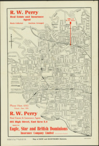
Map - Map of Kew and Hawthorn Districts
... Map of Kew, East Kew and Hawthorn produced for a Kew Real..., East Kew... of Kew, East Kew and Hawthorn produced for a Kew Real Estate ...Map of Kew, East Kew and Hawthorn produced for a Kew Real Estate Agent, RW Perry. The map is undated.Two-colour map of Kew and Hawthorn Districts produced for by R.L. Jarrett for RW Perry, Real Estate & Insurance Agent. The map has unusual features such as a planned railway link from Kew Station to the former Outer Circle Railway. RW Perry / Real Estate & Insurance Agent, 602 High Street, East Kewmaps - kew (vic), maps - hawthorn (vic), r.w. perry, real estate agents -- kew (vic.) -
 Kew Historical Society Inc
Photograph - High Street, Kew, 1960-65
... The borders of the main components of Kew and Kew East have... to Windsor Avenue, and also to the East Kew Station (now demolished...High St East Kew / Corner of Harp Rd. / Looking South... The borders of the main components of Kew and Kew East have not always ...The borders of the main components of Kew and Kew East have not always conformed to current boundaries. In the past this photograph has been labelled as East Kew, whereas for most of the twentieth century the site has been within Kew's borders. The purpose of the photograph is unrecorded yet it has value in that it shows those businesses who occupied this site in Kew during the early 1960s.This small photograph is significant as it shows the location of and building used by WD Vaughan, former Mayor of Kew who was a successful newspaper proprietor in Melbourne.Small polaroid colour positive of High Street in Kew, probably in the 1960s. From left we can see the brick viaduct covering the tracks of what was once the Outer Circle Railway. Behind this brick wall, Dunnings Timber Yard was situated. At the end of the walls of the viaduct there is an entrance to a walkway [now the Anniversary Trail], which once provided access to Windsor Avenue, and also to the East Kew Station (now demolished and part of the Outer Circle Railway Reserve). On the other side of this walkway is a cream brick building (demolished) occupied at this time by WD Vaughan Pty Ltd, printer and publisher of the Kew Advertiser (newspaper). Stretching behind the brick facade is an extensive building that must have housed the printing works. Beside Vaughan's, there is a large building (demolished) housing at that time an estate agent named AJ Kennedy. This area is now separated by kerbing.High St East Kew / Corner of Harp Rd. / Looking South -
 Uniting Church Archives - Synod of Victoria
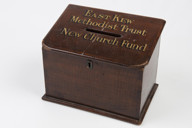
Poor fund box
... East Kew Methodist Trust..."EAST KEW Methodist Trust New Church Fund"... Street Malvern East melbourne East Kew Methodist Trust Fund box ...Varnished wooden box with a lock, hinged lid and black and gilt text."EAST KEW Methodist Trust New Church Fund"east kew methodist trust, fund box -
 Melbourne Legacy
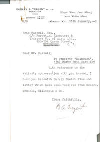
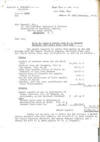
Document, re Property "Holmbush", 1267 Burke Road East Kew, 1943
... re Property "Holmbush", 1267 Burke Road East Kew... Property "Holmbush", 1267 Burke Road East Kew Document ...Formal identification of the property to be bought as the first Melbourne Legacy residence sent to Legatee E. Russell, Chair of the Hostel Committee. The survey is hand drawn and meticulously measured.The documents demonstrate business practices in the 1940s with regard to the purchase of property, as well as being an important record of the first property to be purchased by Melbourne Legacy as a residence for children.00310.1 Letter from Dudley A. Tregent, Solicitor, dated 15 January 1943, to Legatee E. Russell, Chair of the Hostel Committee, enclosing the survey sketch plan. White paper, black letterhead and typing, two holes punched for filing 00310.2 Survey sketch plan by Meudell, Gillespie & Co, dated 13 January 1943. Black type and printing, with some red shading and writing, on white foolscap paper. 00310.3 Letter from Meudell, Gillespie & Co to Mr. D.A. Tregent, Solicitor. Quarto, black typing, red underlining, on white.00310.1 Signed by D.A. Tregent 00310.2 Signed by Percival A. Jordan 00310.3 Signed by Percival A. Jordanholmbush initial negotiations, properties, holmbush -
 Melbourne Legacy
Letter - Document, letter, re D. N. Craig and Others from W.G. Thomson / Property 1267 Burke Road, East Kew, 1943
... Burke Road, East Kew... / Property 1267 Burke Road, East Kew Letter Document, letter ...Letter from Dudley A Tregent, Solicitor showing an outline of the final payment required for purchase of the Holmbush property, including stamp duty, transfer of Title fees and Council Rates. A record of the costs of acquiring property as well as being an important record of the first property to be purchased by Melbourne Legacy as a residence for children.Quarto copy paper, black and white, two hole punched for filing.holmbush initial negotiations, holmbush, properties -
 Melbourne Legacy
Letter - Document, letter, re Property 1267 Burke Road, East Kew, 1943
... re Property 1267 Burke Road, East Kew... for filing. re Property 1267 Burke Road, East Kew Letter Document ...00331.1 A copy of the letter from the solicitor to the real estate agents that handled the transaction to claim for the return of items included in the purchase of the Holmbush property that were removed by the previous owner. 00331.2 A note to accompany the copy of the letter.Business practices in the 1940s around the purchase of the first property by Melbourne Legacy as a residence for children.00331.1 Quarto white copy paper, black type, two hole punched for filing. 00331.2 White note paper, black type, two hole punched for filing.holmbush initial negotiations, holmbush -
 Kew Historical Society Inc
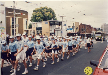
Photograph, St Anne's East Kew, Kew Festival, 1992
... St Anne's East Kew, Kew Festival... East Kew, Kew Festival Photograph Photograph ...The Kew Festival began in 1974. A feature of many festivals were the festival parades in which community groups participated. None of the photographs in the album are named so KHS welcomes viewers to identify participants and or locations.Photograph from an album depicting participants in the 1992 Kew Festivalkew festival - 1992 -
 Kew Historical Society Inc
Photograph - Chipperfield's floating 'Pontoon' on the Yarra River, Ron Setford, 1960
... Yarra River -- Kew East (Vic.)... Avenue, East Kew, from c.1946 to c.1995. A keen photographer, he... Avenue, East Kew, from c.1946 to c.1995. A keen photographer, he ...Ron Setford and his wife Grace Setford lived in Tanner Avenue, East Kew, from c.1946 to c.1995. A keen photographer, he recorded the changing face of Kew over a 20 year period. Apart from 30 photographs of built structures and places in Kew dating from 1960 and 1961, 145 of his 35mm colour slides chronicle the development of the Eastern Freeway through the Yarra Valley over a five year period from c.1972 to c.1977. This important collection was donated to the Society by his granddaughter in 2025.This collection of 175 35mm slides is of local and statewide significance, owing to its subject matter, particularly the major development of road transport infrastructure during the 1970s with the construction of the Eastern Freeway. The photographer also took care to annotate and date most of his slides which enable the researcher to pinpoint temporal and spatial locations.Nilron setford, photographs -- kew (vic.) -- 1960s, yarra river -- kew east (vic.), chipperfield's boat house, chipperfield's floating pontoon -
 Kew Historical Society Inc
Photograph - Beach near Chipperfield's floating 'Pontoon', Ron Setford, 1960
... Yarra River -- Kew East (Vic.)... Avenue, East Kew, from c.1946 to c.1995. A keen photographer, he... Avenue, East Kew, from c.1946 to c.1995. A keen photographer, he ...Ron Setford and his wife Grace Setford lived in Tanner Avenue, East Kew, from c.1946 to c.1995. A keen photographer, he recorded the changing face of Kew over a 20 year period. Apart from 30 photographs of built structures and places in Kew dating from 1960 and 1961, 145 of his 35mm colour slides chronicle the development of the Eastern Freeway through the Yarra Valley over a five year period from c.1972 to c.1977. This important collection was donated to the Society by his granddaughter in 2025.This collection of 175 35mm slides is of local and statewide significance, owing to its subject matter, particularly the major development of road transport infrastructure during the 1970s with the construction of the Eastern Freeway. The photographer also took care to annotate and date most of his slides which enable the researcher to pinpoint temporal and spatial locations.Nilron setford, photographs -- kew (vic.) -- 1960s, yarra river -- kew east (vic.), chipperfield's boat house, chipperfield's floating pontoon -
 Melbourne Tram Museum
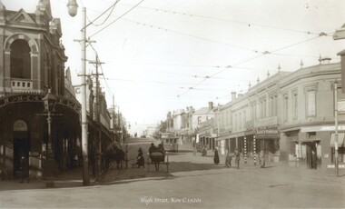
Photograph - Black and white - High St Kew c1920's
... Shows High St Kew, looking east from the junction...Black and white photograph of High St Kew, looking east... Shows High St Kew, looking east from the junction with a four ...Shows High St Kew, looking east from the junction with a four wheel tram approaching the intersection with people waiting to board the tram. On the right is a sign "Happy Thoughts - the trade supplied" and under it "Lucy Hinton Tobacco"Yields information about the location, the streetscape and the trams and vehicles in use at the time. Black and white photograph of High St Kew, looking east with a four wheel tram in the view."RSCP 328" & "C1918" in pencil on rear.tramways, trams, kew junction, high st kew, tram stops -
 Kew Historical Society Inc
Plan - Subdivision Plan, Kewdene Estate, 1937-1939
... subdivision plans - east kew... of the City of Melbourne. Most of these are of Kew, Kew East ...Pru Sanderson, in her groundbreaking ‘City of Kew Urban Conservation Study : Volume 2 - Development History’ (1988), summarised the periods of urban development and subdivisions of land in Kew. The periods that she identified included 1845-1880, 1880-1893, 1893-1921, 1921-1933, 1933-1943, and Post-War Development. These periods were selected as they represented periods of rapid growth or decline in urban development. An obvious starting point for Sanderson’s groupings involved population growth and the associated economic cycles. These cycles also highlighted urban expansion onto land that was predominantly rural, although in other cases it represented the decline and breakup of large estates. A number of the plans in the Kew Historical Society’s collection can also be found in other collections, such as those of the State Library of Victoria and the Boroondara Library Service. A number are however unique to the collection.The Kew Historical Society collection includes almost 100 subdivision plans pertaining to suburbs of the City of Melbourne. Most of these are of Kew, Kew East or Studley Park, although a smaller number are plans of Camberwell, Deepdene, Balwyn and Hawthorn. It is believed that the majority of the plans were gifted to the Society by persons connected with the real estate firm - J. R. Mathers & McMillan, 136 Cotham Road, Kew. The Plans in the collection are rarely in pristine form, being working plans on which the agent would write notes and record lots sold and the prices of these. The subdivision plans are historically significant examples of the growth of urban Melbourne from the beginning of the 20th Century up until the 1980s. A number of the plans are double-sided and often include a photograph on the reverse. The advertisement for the ‘Kewdene Estate’ subdivision is pasted over a photograph of a property for sale. This is typical of the reuse of promotional materials in the period during, and subsequent to World War I. The subdivision included 14 lots bordered by Belmore Road, Birtles Street and Giles Street. On the other side of the subdivision [Glass] Creek is noted. The subdivision plan also shows part of the Outer Circle Railway and Deepdene Railway Station.subdivision plans - east kew, kewdene estate, belmore road -- kew east (vic.), giles street -- kew east (vic.) -
 Melbourne Tram Museum
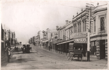
Photograph - Kew Junction looking North East - horse tram, c1900
... Kew Junction looking North East - horse tram...Photograph, looks north east along High St Kew, from Kew...Photograph, looks north east along High St Kew, from Kew ...Photograph, looks north east along High St Kew, from Kew Junction. Has a horse tram climbing the hill. There are signs for Canary tobacco, F O Stowe Fruiter Confectioner, Alice cycle works, a tobacconist Geo Neubecker, advertising Perfection, Havelock and Two Seas tobacco, and Farland Timms & Co Produce Merchants. One horse drawn cart is parked outside the Produce shop.Yields information about Kew Junction c1900.Black and white photograph with notes on the rear.Has on the rear in pencil "Kew Junction" and number "186"tramways, horse trams, kew junction, high st kew -
 Ballarat Heritage Services
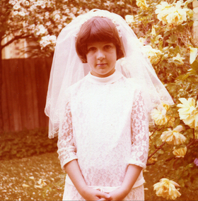
Photograph - Colour, First Communicate, 10/1978
... East Kew....Beresford St , East Kew, Victoria, Australia... at St Anne's East Kew. lisa gervasoni first holy communion ...Lisa Gervasoni made her First Holy Communion at St Anne's East Kew.Colour photograph of Lisa Gervasoni wearing her First Holy Communion outfil lisa gervasoni, first holy communion -
 Kew Historical Society Inc
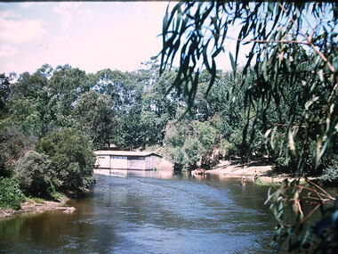
Photograph, City of Kew, Glass' Creek, Hays Paddock, Kew, c.1980
... glass' creek - kew east (vic)...' creek - kew east (vic) hays paddock - kew east (vic) Enlarged ...One of a series of photos created for an exhibition by the City of Kew of notable locations. The photos represent a snapshot in time.Enlarged photograph mounted on board, donated to the Kew Historical Society by the City of Kew on 10 April 1991.glass' creek - kew east (vic), hays paddock - kew east (vic) -
 Kew Historical Society Inc
Plan - Willsmere Park Estate, Kew, 1926
... subdivisions -- kew east (Vic.)... (Vic.) subdivisions -- kew east (Vic.) willsmere park -- Kew ...Subdivision plans and real estate flyers/brochures reveal a number of aspects of urban development and history. The Kew Historical Society's collection of these plans, as well as advertisements extracted from magazines, cover key aspects of community development and architectural history of Kew and Kew Eat as well as surrounding suburbs. While most of the plans in the collection were gifted to the Society by the former City of Kew, a number of other plans and advertisements have been donated by individuals, of which this is an example.Original 4-page, bifold subdivision plan of the Willsmere Park Estate, Kew. The 1926 land sale advertised '40 superb villa allotments' on the 'Yarra Heights'. Streets within the subdivision included: Willow Grove, Kilby Road, Elm Grove and Belford Road. The double page spread on pages 2 and 3 shows the detailed plan of the 40 lots, surrounded by public parkland [Willsmere Park] and the Kew Golf Links. By the time that this version of the plan was released, only the lots on Willow Grove and Kilby Road remained. willsmere park estate -- kew (vic.), subdivisions - kew (vic.), subdivisions -- kew east (vic.), willsmere park -- kew east (vic.) -
 Melbourne Tram Museum
Slide - Set of 23 - MMTB Tram substations and offices, Robert Green, 3/1990
... East Kew... North Fitzroy 13 - Holden St North Fitzroy 14 - East Kew - High... 13 - Holden St North Fitzroy 14 - East Kew - High St. 15 ...Set of 23 colour slides of MMTB tramway substations and the Victoria St Office, by Robert Green Mar 1990. 1 - Carlton Substation - Queensberry St. 2 - Carlton Substation - Queensberry St. 3 - Coburg - Moore St 4 - Glen Huntly Depot substation 5 - Fitzroy - Young St. 6 - Fitzroy - Young St. 7 - Station St Camberwell 8 - Malvern Tram depot 9 - Brunswick Rd, Brunswick 10 - Brunswick Rd, Brunswick 11 - Brunswick Rd, Brunswick 12 - Holden St North Fitzroy 13 - Holden St North Fitzroy 14 - East Kew - High St. 15 - East Kew - High St. 16 - East Kew - High St. 17 - East Kew - High St. 18 - Little Bourke St Melbourne 19 - Former branch offices - Victoria Parade Fitzroy 20 - Former branch offices - Victoria Parade Fitzroy 21 - Former branch offices - Victoria Parade Fitzroy 22 - Former branch offices - Victoria Parade Fitzroy - 2004 23 - Former branch offices - Victoria Parade Fitzroy = 2004Yields information about Melbourne tramway substationsSet of 23 Kodak colour slides in plastic mounts.All slides have their location marked on them in black ink.tramways, mmtb, substations, carlton, queensberry st, coburg, glen huntly, north fitzroy, young st, camberwell, malvern depot, brunswick road, brunswick, holden st, east kew, little bourke st, branch offices, victoria parade -
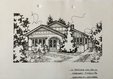 Kew Historical Society Inc
Drawing - Property Illustration, Margaret Picken, 6 Maitland Avenue, Kew, 1996
... , Kew East, by Margaret Picken.... drawing on drafting film of 6 Maitland Avenue, Kew East ...After training as a Cartographic Draftsman within the mining industry, I worked as a property illustrator for real estate firms in the eastern suburbs of Melbourne for 23 years from 1983. I initially photographed houses with a Polaroid camera and made a 'thumbnail' sketch while there. The photos were used to scale off a sketch in pencil and then that sketch was overlaid with drafting film and the 'pen and ink' completed. The pens I used were the Rotring ‘Rapidigraph’ drafting pens. The ink was also made by Rotring (German).The film was ‘Rapidraw’, polyester drafting film, double matte. It takes a very fine line and doesn’t bleed. As well as house sketches, there were often floor plans and site plans ordered. Aerial sketches were ordered when the property needed an overall view. (Margaret Picken, 2020)This drawing is one of a series created by Margaret Picken for real estate agents in Melbourne between 1983 and 2006. Each work is signed and dated by the artist.Gift of Margaret Picken, 2020Pen and ink drawing on drafting film of 6 Maitland Avenue, Kew East, by Margaret Picken.6 MAITLAND AVE., KEW E. / MARGARET PICKEN ~96 / WOODARDS ~ HAWTHORNartist -- margaret picken 1950-, property illustrations — buildings — kew (vic.), 6 maitland avenue - kew (vic) -
 Kew Historical Society Inc
Biographical information, Ronald Horace Setford (1915–1988)
... 9 Tanner Avenue -- Kew East (Vic... Avenue, East Kew, part of the Old Golf Links Estate, for £225... Avenue, East Kew, part of the Old Golf Links Estate, for £225 ...Ronald Horace Setford was born in April 1915 at 18 Church Street, Hawthorn, at his family’s home above their decorator shop. He was the second of three sons born to Horace Turner Setford (1880-1944) and Mabel Crofts (1887-1943). He attended Hawthorn West Primary School and then Swinburne before beginning work in his family’s business ‘Setford and Son’ in October 1930. This was formalised in April 1931 when he became a carpentry and joinery apprentice. In 1934 he graduated as a grade four carpenter. Ron worked in the family business until 1964 and then worked at J S Kidd and Co Pty Ltd as a storeman until his retirement in December 1973. Ron married Grace Muriel Agnes Perrey (1915-2001) in 1936 and they first lived in Kew around 1940, at 38 Marshall Avenue. Ron served in the Citizen Military Forces as a sapper with the 9 Australian Army Transport Company, Royal Australian Engineers, signing up a week after Darwin had been bombed. He spent time in Darwin, Wayville (South Australia), Herberton and Grovely (Queensland). Afterwards he refused to eat rice, never spoke of the war, nor took part in any ANZAC day proceedings. In 1941, Ron and Grace bought their block of land at 9 Tanner Avenue, East Kew, part of the Old Golf Links Estate, for £225. It was not until December 1945 that Ron started building their home and they moved in during May 1947. Ron and Grace remained there for thirty-seven years until the house was sold to their nephew in 1984. It has since been demolished. Ron’s great passion was photography and in the early 1960s he purchased his Minolta camera. Slide evenings at Tanner Avenue were a regular occurrence. Ron made his own title slides, interval slides and end slides. As well as many holiday photos (around Australia and their world trip in 1966), he enjoyed photographing local landmarks, flowers, insects and family. One of Ron’s photography projects was to record the progress of the building of the Eastern Freeway. This was near their home, and he’d walk down to the works on a regular basis, dressed smartly, with his camera in hand. The workers thought he was an official photographer, and he was allowed on site to take his photos. In 1984, Ron and Grace downsized and moved to Bayswater. Ron passed away on 31 October 1988 at the Maroondah Hospital in Ringwood East, at age 73. His ashes were spread on his beloved rose bushes at Tanner Avenue. Lauren Thomson, 2025ron setford, 9 tanner avenue -- kew east (vic, setford and son -- 18 church st (hawthorn), grace muriel agnes perrey, 9 australian army transport company, j s kidd and co pty ltd, eastern freeway, f19 freeway -
 Kew Historical Society Inc
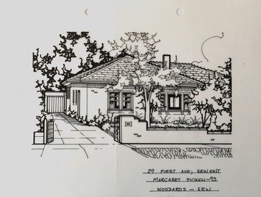
Drawing - Property Illustration, Margaret Picken, 29 First Avenue, Kew, 1993
... 29 FIRST AVE., KEW EAST / MARGARET PICKEN ~93 / WOODARDS...., KEW EAST / MARGARET PICKEN ~93 / WOODARDS ~ KEW Pen and ink ...After training as a Cartographic Draftsman within the mining industry, I worked as a property illustrator for real estate firms in the eastern suburbs of Melbourne for 23 years from 1983. I initially photographed houses with a Polaroid camera and made a 'thumbnail' sketch while there. The photos were used to scale off a sketch in pencil and then that sketch was overlaid with drafting film and the 'pen and ink' completed. The pens I used were the Rotring ‘Rapidigraph’ drafting pens. The ink was also made by Rotring (German).The film was ‘Rapidraw’, polyester drafting film, double matte. It takes a very fine line and doesn’t bleed. As well as house sketches, there were often floor plans and site plans ordered. Aerial sketches were ordered when the property needed an overall view. (Margaret Picken, 2020)This drawing is one of a series created by Margaret Picken for real estate agents in Melbourne between 1983 and 2006. Each work is signed and dated by the artist.Gift of Margaret Picken, 2020Pen and ink drawing on drafting film of 29 First Avenue, Kew by Margaret Picken.29 FIRST AVE., KEW EAST / MARGARET PICKEN ~93 / WOODARDS ~ KEWartist -- margaret picken 1950-, property illustrations — buildings — kew (vic.), 29 first avenue -- kew (vic.) -
 Kew Historical Society Inc
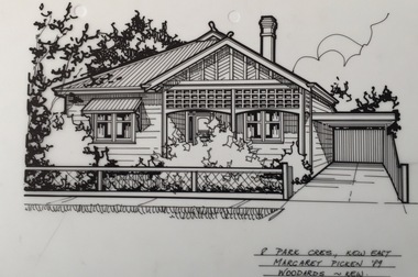
Drawing - Property Illustration, Margaret Picken, 8 Park Crescent, Kew, 1989
... 8 PARK CRES., KEW EAST / MARGARET PICKEN '89 / WOODARDS... EAST / MARGARET PICKEN '89 / WOODARDS ~ KEW Pen and ink drawing ...After training as a Cartographic Draftsman within the mining industry, I worked as a property illustrator for real estate firms in the eastern suburbs of Melbourne for 23 years from 1983. I initially photographed houses with a Polaroid camera and made a 'thumbnail' sketch while there. The photos were used to scale off a sketch in pencil and then that sketch was overlaid with drafting film and the 'pen and ink' completed. The pens I used were the Rotring ‘Rapidigraph’ drafting pens. The ink was also made by Rotring (German).The film was ‘Rapidraw’, polyester drafting film, double matte. It takes a very fine line and doesn’t bleed. As well as house sketches, there were often floor plans and site plans ordered. Aerial sketches were ordered when the property needed an overall view. (Margaret Picken, 2020)This drawing is one of a series created by Margaret Picken for real estate agents in Melbourne between 1983 and 2006. Each work is signed and dated by the artist.Gift of Margaret Picken, 2020Pen and ink drawing on drafting film of 8 Park Crescent, Kew by Margaret Picken.8 PARK CRES., KEW EAST / MARGARET PICKEN '89 / WOODARDS ~ KEWartist -- margaret picken 1950-, property illustrations — buildings — kew (vic.), 8 park crescent - kew (vic) -
 Kew Historical Society Inc
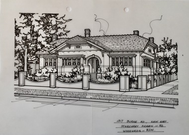
Drawing - Property Illustration, Margaret Picken, 1317 Burke Road, Kew, 1992
... 1317 BURKE RD., KEW EAST / MARGARET PICKEN ~92 / WOODARDS...., KEW EAST / MARGARET PICKEN ~92 / WOODARDS ~ KEW Pen and ink ...After training as a Cartographic Draftsman within the mining industry, I worked as a property illustrator for real estate firms in the eastern suburbs of Melbourne for 23 years from 1983. I initially photographed houses with a Polaroid camera and made a 'thumbnail' sketch while there. The photos were used to scale off a sketch in pencil and then that sketch was overlaid with drafting film and the 'pen and ink' completed. The pens I used were the Rotring ‘Rapidigraph’ drafting pens. The ink was also made by Rotring (German).The film was ‘Rapidraw’, polyester drafting film, double matte. It takes a very fine line and doesn’t bleed. As well as house sketches, there were often floor plans and site plans ordered. Aerial sketches were ordered when the property needed an overall view. (Margaret Picken, 2020)This drawing is one of a series created by Margaret Picken for real estate agents in Melbourne between 1983 and 2006. Each work is signed and dated by the artist.Gift of Margaret Picken, 2020Pen and ink drawing on drafting film of 1317 Burke Road, Kew by Margaret Picken.1317 BURKE RD., KEW EAST / MARGARET PICKEN ~92 / WOODARDS ~ KEWartist -- margaret picken 1950-, property illustrations — buildings — kew (vic.), 1317 burke road - kew (vic) -
 Kew Historical Society Inc
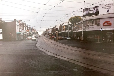
Photograph, Stewart West, Kew Junction Looking West along High Street, 1995
... High Street, Kew, looking east from Kew Junction. c. 1995... High Street, Kew, looking east from Kew Junction. c. 1995 Kew ...Photo created for a display about Kew comparing old (19th) and new (20th century) photographsProvides a picture of High Street Kew in the decade following the second widening of High Street in the 1950s.High Street, Kew, looking east from Kew Junction. c. 1995high street (kew), kew junction, stewart west -
Kew Historical Society Inc
Archive (Sub-series) - Subject File, Barnard Grove (Kew), 1985
... barnard grove - kew east (vic.)... sources. barnard grove - kew east (vic.) Archive file containing ...Dorothy Benyei & Rosemary SmartReference, Research, InformationKHS OrderSubject file containing responses to a survey of residents of Barnard Grove, Kew (Vic), issued in 1985. The questionnaire requested information about when the respondee/s moved into the street, whether alterations had been made to their house, the reason why they moved to Barnard Grove, its good points and its limitations, and further comments. Rosemary Smart and Dorothy Benyei conducted the survey on behalf of the Society. The file contains many interesting responses from those who returned the surveys.barnard grove - kew east (vic.)barnard grove - kew east (vic.) -
Kew Historical Society Inc
Archive (Sub-series) - Subject File, Bicycle Paths, 1958
... willsmere park - kew east (vic.)... sources. bicycle paths - kew (vic.) willsmere park - kew east (vic ...Various partiesReference, Research, InformationKHS OrderSmall file containing two newspaper articles, the first a general article on cycling and the other on opposition to bike paths in Willsmere Park.bicycle paths - kew (vic.), willsmere park - kew east (vic.)bicycle paths - kew (vic.), willsmere park - kew east (vic.)