Showing 5241 items
matching level
-
 Glenelg Shire Council Cultural Collection
Photograph - Photograph - Cape Grant Quarry, n.d
PORT OF PORTLAND AUTHORITYBack: Purple PHT stamp -
Glenelg Shire Council Cultural Collection
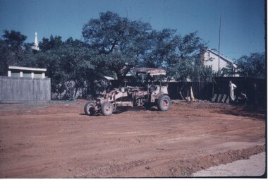
Slide - Slide - Cashmore Airport, Portland, 1980s
Coloured slide. Large flattened area, built up to be same level. Several rollers and graders in background.portland airport, cashmore airport, construction, engineering, air travel -
Federation University Historical Collection
Document, Peter Fryar, A short history and discussion paper regarding factors influencing the introduction of "Physical Education" courses into Victorian Tertiary Education and to Ballarat Post Secondary Institutions in particular, by Peter Fryar
Retired Dean of the Faculty of Human Studies, Peter Fryar, was invited to prepare this short history for lodgement in the University of Ballarat Historical Collection (later Federation University Historical Collection).10 typed pages by Peter Fryar outlined introduction of Physical Education studies at a Tertiary Level at Ballarat peter fryar, physical education, mount helen campus -
 City of Ballarat
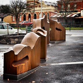
Artwork, other - Public Artwork, Cliff Burtt, Buninyong Bivium, 2016
Buninyong Bivium (2016) by Cliff Burtt engages with the geography and history of the Buninyong region in both pre and post settlement. The town of Buninyong is dominated by the profiles of Mt Helen and the extinct volcano Mt. Buninyong. Traditional land of the Wadawurrung people, today the area remains a significant site for the culture of indigenous people and their connection to the land. The profile of this sculpture is based on topographical mapping of the area, depicting sections of the landscape. The gaps between the elements of the work can be viewed as representations of the shafts sunk into the earth by the early gold miners and compound curves on the upper surfaces are mirroring the topography of the area, while cut-aways in the sides are suggestive of rock strata.The artwork is of aesthetic and social significance to the people of BallaratCorten steel sculpture made of five unique sculptural pieces secured to at concreate base at pavement levelbuninyong, cliff burtt, sculpture, public art, mining, ballarat -
 Whitehorse Historical Society Inc.
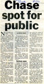
Article, Chase spot for people, 1991
Nunawading Council may gain a large area of community space on the 3rd level of Forest Hill Chase.Nunawading Council may gain a large area of community space on the 3rd level of Forest Hill Chase.Nunawading Council may gain a large area of community space on the 3rd level of Forest Hill Chase.forest hill chase, nunawading -
Whitehorse Historical Society Inc.
Document, Eastern suburbs map, n.d
Hand drawn map of eastern suburbs and railways of eastern suburbs showing heights above sea levelrailways, maps -
 Rutherglen RSL Sub-Branch
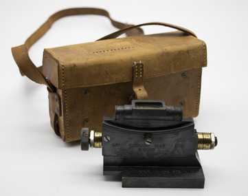
Functional object - Clinometer sight in leather carrying case
Clinometer sight has black metal and brass elevation scale, spirit level on top of sight with baseAUST. F. TOUGH 1943 D^D/A.6038/CLINCOMETER. SIGHT MK (ii)/CLINOMETER VICKERS .303 IN. M.G/MKII REVERSE SIDE : ELEVATION SCAALE NUMBER 20D-5D. 0-20E BASE : TARGET -
 Bendigo Historical Society Inc.
Slide - DIGGERS & MINING: BENDIGO
Diggers & Mining: Bendigo. Rosalind Park, lower level. Markings: 02 DEC76M10. Used as a teaching aid.Kodachromeeducation, tertiary, bendigo -
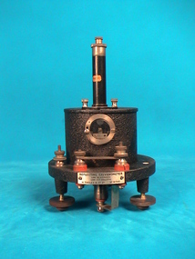 The Ed Muirhead Physics Museum
Galvanometer, Tinsley
Used to measure electrical current. Cylindrical reflecting vertical galvanometer. Case made of black enamelled metal and standing on three legs for levelling.Label “Part 2”. Label “Purchase of University Commission”. Plaque on front “Reflecting galvanometer, link in aperiodic link out ballistic, H. Tinsley & Co. Ltd No. 41545” -
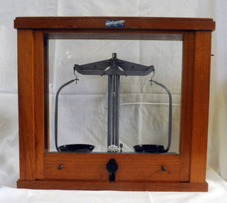 Orbost & District Historical Society
beam balance, second half 20th century 1954-1999
These scales were used by students at St Joseph's School in Orbost. St Joseph's Catholic School in Orbost was planned from 1913 when the town's population was increasing rapidly. It wasn't until 1923 that the school was built in Raymond Street next to St Colman's Church. The Catholic school was opened in thecharge of Sister Moira and Sister Lucy, Fifty-five students were initially enrolled and taught in two rooms. When the numbers increased to 170 work began on extensions which were completed in 1959. St Joseph's school had classes to Form 4 at one stage. Later on Form 2 was the highest level. However, after Nagle College at Bairnsdale built a new school on the Lindenow Road site, a Nagle College school bus ran from Orbost and the school was reduced to Grade 6. It was also about this time that the last of the St Joseph teaching nuns left Orbost. From 1969 to the early 1980s the secondary St Joseph students attended Orbost High School for the practical subjects of Woodwork and Home Economics. Today enrolments reflect the declining population of the district.This item is an example of early school equipment.A set of beam balance scales in a wooden framed cabinet with glass windows on all for sides. The front is a vertical slide which allows acess to the scales. The scales have one fixed leg and two adjustable legs for accurate levelling. GRIFFIN GEORGE LIMITED, LONDON, BIRMINGHAM, MANCHESTER label on front of wooden section of case -ANALITE PTY LTD ASG@W EDINBURGH MADE IN GREAT BRITAIN MINOR REG DES No's 891235 & 891238education science scientific-apparatus measurement -
 Bendigo Historical Society Inc.
Tool - HOME MADE SPIRIT LEVEL
Home-made Spirit Level approx. 30 cm long. Round piece of 2cm Dowel, flattened on one side. Contains a small glass tube with liquid and air bubble inside. The glass tube is kept in place by a metal sleeve with small window to form a spirit level. -
 Whitehorse Historical Society Inc.
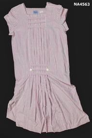
Clothing - Maternity Dress, c. 1989
Pink and white striped cotton maternity dress. Square neckline with short sleeves. Seven pleats across centre of front with a white pearly button on each side at hip level. Three bands across at neck and another three at hip level. Back of dress is identical to the front.Daly Jones 12costume, female -
 Kew Historical Society Inc
Photograph - Flooding of the Yarra Valley at Kew East, 1974
Flooding of the Yarra Valley, including that section of the Yarra bordering Kew and Kew East in the north and west of the municipality, was a regular occurrence. Extreme flood events of the Yarra River are recorded to have occurred in 1891, 1901, 1916, 1923 and 1934. The Municipality of Kew's response to these floods was to enact planning decisions restricting residential development in flood prone areas following the floods of 1916, 1921 and 1934. While floods continued after the development of the Upper Yarra Reservoir (construction 1948-57), the regularity and extent of these inundations diminished. During the nineteenth century, the land abutting the south side of the Yarra in Kew was devoted to dairy farming. In the twentieth century, before and after the construction of the Eastern Freeway, much of this low-lying area was used as golf courses and public parks.Late example of the capacity of the Yarra Valley at Kew to flood, even though drainage works and the Upper Yarra Reservoir had reduced their regularity.Original black and white print photograph of the low-lying land at East Kew under floodwater on 16 May 1974. The photograph is of Hyde Park looking north-east.Annotation verso: "Hyde Park looking nth-east / Flood Level / 16 May 1974 11.15am / R.L. 46.61"floods, yarra river, hyde park -
Glenelg Shire Council Cultural Collection
Photograph - Photograph - Portland Butter Factory, M. E. Andrews, n.d
The Portland Butter Factory opened in a new building 1935 on the Heywood Road. The opening of the building was attended by K. S. AndersonBlack and white photo of the Portland butter factory. Timber building, split level, large brick tapered chimneyBack: 'Butter Factory Portland' - handwritten in black ink Round purple stamp 'PRINTED BY M.E. ANDREWS PORTLAND'portland industry, dairy, trade -
 Federation University Historical Collection
Equipment - Chemistry vessel, Chemistry apparatus
Removed from SMB campus when the TAFE Chemistry class closed.Glass vessel with hourglass shape, top opening, and 2 round side openings, side openings at different levels.chemistry apparatus, glass vessel, test tube, lecture demonstration equipment -
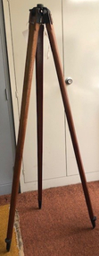
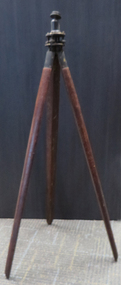 Federation University Historical Collection
Equipment - Tripod, Surveying Instrument, early 1900s
Tripod with 3.5 cm male thread tiltable mount (to suit Level CS - 147, 4110.) Wooden legs.surveying, tripod -
Glenelg Shire Council Cultural Collection
Photograph - Photograph - Quarry, Cape Grant, n.d
Port of Portland Authority Archivesport of portland -
 Rutherglen Historical Society
Image, Redmond Weller, 1950s
One of a collection of photos taken from slides by Mr Redmond Wheler, during his time as Head Master a Rutherglen State Higher Elementary SchoolColour photograph of a block of land being levelled by earth-moving machine, possibly for an extension to a school or school yard.rutherglen schools -
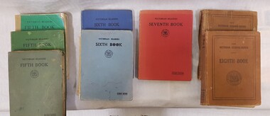 Numurkah & District Historical Society
Book - Victorian Readers x 9, Victorian Readers Fifth Book (4) / Victorian Readers Sixth Book (2) / Victorian Readers Seventh Book ( 1) / Victorian Readers Eighth Book (2)
9 x Victorian Readers books, Cardboard covers, various colours depending on year level (see photo)Victorian Readers with Education Department logoeducation, school, reading, readers, english -
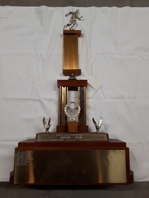 Vision Australia
Photograph - Image, River Run Female Winner trophy
A race along the banks of the Yarra River (?) this trophy was awarded to the female winners from 1978-1987. A golden running figure sits atop a pedestal that rests on a bell located above two pedestals behind a golden laurel wreath. Two eagles, with wings outstretched as if just landing, are either side of the wreath and the inscription 'Rotary Club of Glenferrie - River Run - Female winner - Donated by Bob Bruner' is written on the plinth below them. On the base plinth are inscribed the names of the previous winners: 1978 Lynne Williams 1979 Lynne Williams 1980 Lynne Williams 1981 Dorothy Browne 1982 Dorothy Browne 1983 Michelle Baumgarten 1984 Laura Dess 1985 Mary Edwards 1986 Julie McKie 1987 Julie McKieGold running figure atop two levels of columns with a wreath and two eagles at the base, whereupon names are inscribedRotary Club of Glenferrie River Run Female Winner Donated by Bob Brunerassociation for the blind, awards -
 University of Melbourne, Burnley Campus Archives
Tool, Tripod, Pre 1960's
Large timber tripod with means of attachment for dumpy level (but not B24.0049). See B91.126 for photograph of tripod in use by a student.surveying equipment, students, landscaping, dumpy level -
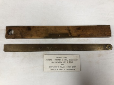 Mont De Lancey
Spirit Level and Ruler, 1. Made between 1833 & 1863. 2. Circa 1920
1. Wooden Spirit level with brass fittings and 2 foot ruler. 2. Metal Carpenters folding ruler.carpentry tools, spirit levels, folding rules -
Glenelg Shire Council Cultural Collection
Photograph - Photograph - Cape Grant Quarry, n.d
Port of Portland Authority Archivesport of portland archives, cape grant quarry -
 Bendigo Historical Society Inc.
Map - FORTUNA HUSTLER'S MINE - PLAN OF THE FORTUNA HUSTLER'S MINE
Plan of the Fortuna Hustler's Mine, Bulletin No 33, Plate No II. Geological Survey of Victoria. Signed by H A Whitelaw, Underground Survey Office Bendigo, September 1913. Map shows levels and depths. There are smaller drawings of some sections of some levels. This item has not been scanned or photographed.mining, parish map, fortuna hustler's mine, plan of the fortuna hustler's mine, geological survey of victoria, h a whitelaw, underground survey office bendigo -
Whitehorse Historical Society Inc.
Article, Say no to pokies: shoppers alarm, 1992
Residents will fight plans to develop a tavern with 90 poker machines in Forest Hill Chase Shopping Centre.Residents will fight plans to develop a tavern with 90 poker machines in Forest Hill Chase Shopping Centre. Nunawading Council's strategic planning department's spokesman, Richard Schuster, said the 3rd level at the Centre has developed into an entertainment level. The matter has not gone before Council at this stage.Residents will fight plans to develop a tavern with 90 poker machines in Forest Hill Chase Shopping Centre.shopping centres, forest hill chase, city of nunawading, schuster, richard -
Glenelg Shire Council Cultural Collection
Photograph - Photograph - Blacknose Quarry, n.d
Port of Portland Authority ArchivesBack: 44 005 stampport of portland archives, blacknose quarry -
Alexandra Timber Tramway & Museum
rubicon black and white photo, Mr Sapsford, skinners bridge at rubicon, 1930
Photographer of local avents and buildings major projects . This photo is of historical avents and a major project at RubiconUn replaceable rubicon photo of skinners bridge ,note two levels of bridge .photo taken by mr sapsford of alexandra . in good condrubicon photo .skinners bridge rubicon -
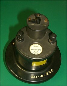 Federation University Historical Collection
Instrument - Scientific Instrument, Cambridge Instrument Co. Ltd, Galvonometer
450 OHM Galvanometer. Black metal case with levelling feet. Clamps and zero adjustment on top. Two terminal posts.scientific instruments, galvonometer, cambridge instrument co. ltd -
Glenelg Shire Council Cultural Collection
Photograph - Photograph - Blacknose Quarry, n.d
Port of Portland Authority ArchivesBack: 44 005 - stampport of portland archives, blacknose quarry -
Glenelg Shire Council Cultural Collection
Photograph - Photograph - Cape Grant Quarry, n.d
Port of Portland Authority Archivesport of portland archives, cape grant, euclid