Showing 8399 items matching "mckillops-bridge"
-
 Marysville & District Historical Society
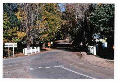
Photograph (Item) - Colour photograph, 05-1985
A colour photograph of the F.J. Barton Bridge in Marysville in Victoria.A colour photograph of the F.J. Barton Bridge in Marysville in Victoria. The F.J. Barton Bridge was named after Frederick John Barton. The Barton Family were amongst Marysville's first pioneering families.F. BARTON BRIDGE/ MARYSVILLE MAY 1985fj barton bridge, marysville, victoria, photograph, frederick john barton -
 Melbourne Legacy
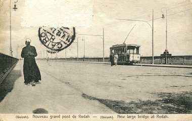
Postcard, New bridge at Rodah, c.1912
Postcards were a common form of souvenirs for soldiers who were travelling either during World War 1, or just after, or while returning to Australia. Was with other World War 1 memorabilia that has come from Private John Basil McLean, 2nd Reinforcements, 37th Battalion, A.I.F. J.B. McLean (Service No. 13824) was from near Maffra, Victoria and enlisted on 22 January 1916. He embarked on 16 December 1916 for Europe. His full war record is available from AWM. He spent time with the Australian Field Artillery (Pack Section). At the end of the war he worked for a year at the A.I.F. Headquarters in London before returning to Australia on the 'Ceramic', arriving Portsea in 1920.Postcards were a very common form of communication in the first World War. This postcard also records Gallipoli for those who didn't have cameras. This type of souvenir would have been familiar to the first Legatees as they had served in World War 1 and many had served at Gallipoli.Postcard showing black and white image of the bridge at Rodah, Guizeh (Giza). Several figures and a tram are also pictured crossing the bridge. A black postal stamp in the top left quadrant of the postcard indicates it was posted from Cairo. The back of the postcard contains a message. Based on the date and location it was posted from, the text could be Egyptian Arabic or it could be Pitman shorthand.Front - “(Guizeh) Nouveau grand pont de Rodah - (Guizeh) New large bridge at Rodah.” Back - “J/15/1912/ CARTE POSTALE / M J?. Hinaul / 20 Rue de Landrecies/ Le Cateau (Nord)/ France/ Ghino Dukich, 21 Rue Nubar Pacha - Le Caire, Egypte/ Serie A No. 25. Reproduction interdite” Stamps - Postes Egyptiennes/ Un Millieme”souvenir, war correspondence -
 Southern Sherbrooke Historical Society Inc.
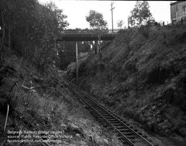
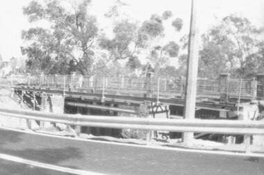
Photograph, Belgrave Railway Bridge, 1947
Belgrave Railway Bridge seen from near railway line on the east side. Photo shows the bridge over a scrubby railway cutting. There are small trees. A truck is parked on the right side of the bridge and perpendicular to the bridge. To the right is a building, presumably US Motors. A sign visible on right end of the bridge is also visible on VSSHP0069.02. -
 Greensborough Historical Society
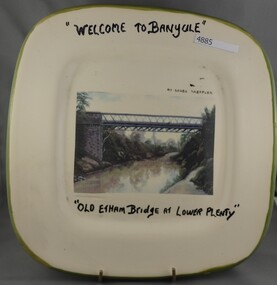
Plate, Serge Daeffler, Old Eltham Bridge at Lower Plenty, 1980s
Ceramic plate, decorated by Serge Daeffler. Hand painted text with transfer illustration of the Old Eltham Bridge at Lower Plenty which was opened on 8/3/1867.Ceramic plate, off-white with green edges, colour transfer photograph, glazed"Welcome to Banyule", "Old Etham (sic) Bridge at Lower Plenty", by Serge Daeffler. Card of Banyule's Heidelberg School Heritage Artist, Robert S, Phillips attached to rear, with price label from Savers.plates, lower plenty -
 Glenelg Shire Council Cultural Collection
Card - Card / Photo - Melbourne Photography Company, n.d
Burgundy card with black and white photo attached to front. Young man in formal attire standing next to stone wall, hand on urn. 'Melbourne Photography Company BRIDGE STREET BALLARAT' printed in gold, beneath photBack: Piece of masking tape, top edge of card, with GRANDFATHER VIVIAN' hand printed, blue biro -
 Ringwood and District Historical Society
Photograph, The old Warrandyte Road bridge viewed across bypass. Ringwood, 1986
Written on back of photograph, "29.11.86. The old bridge viewed across bypass." (Warrandyte Road bridge) -
Ballarat Heritage Services
Photograph - Photograph - Colour, Clare Gervasoni, Docwra Street Bridge, Magpie, Victoria, 2019, 18/05/2019
A bridge built over the Yarrowee Creek at Magpie. It replaced a single lane bridge and was built c2017.magpie, docwra street bridge -
 Sunbury Family History and Heritage Society Inc.
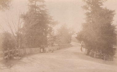
Photograph, C
The people were photographed standing on the Macedon Street bridge which spans the Jacksons Creek at the east end of the town of Sunbury.A sepia photograph in post card format of five people with a dog standing in front of a picket fence on a road bridge.SUNBURY BRIDGEmacedon street bridge, jacksons creek, sunbury -
 Federation University Historical Collection
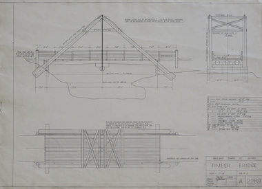
Plan, Plan for a Timber Bridge
Plan for a timber bridgetimber bridge, j. calisto, geoff biddington -
 Ballarat Heritage Services
Plan - Photograph - Colour, Clare Gervasoni, Bridge at Scarsdale, Golden Plains Shire, 1999, 04/10/1999
ncil.vic.gov.au/places/67986)Colour photograph of a bridge.bridge, scarsdale -
 Ballarat Heritage Services
Photograph, Clare Gervasoni, Steiglitz Bridge, 2020, 15/03/2020
Steiglitz Bridge, 2020steiglitz, bridge -
 Port Fairy Historical Society Museum and Archives
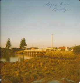
Photograph
Moyne River Bridge 1970's North sideColoured photograph of Moyne river traffic bridge taken from the North side on the West bankMoyne River Bridge- on frontmoyne river, bridge, west side -
 Eltham District Historical Society Inc
Photograph, Diamond Creek Bridge, Eltham North
Photograph copy of original showing the old Eltham North bridge upstream of present Wattletree Road bridgediamond creed, eltham north, wattletree road, coleman crescent, bridges -
 Stawell Historical Society Inc
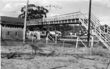
Photograph, Railway Step Bridge Stawell with signal box in the background
This Photograph is a copy printed from a negative owned by the Society - Paid from grant 1991. This is a Photograph of the footbridge over the rail yad at Stawell. A Signal Box in the Background. The Signal box was demolished some years ago. The Footbridge was demolished in 1991.Black and White Photograph of a bridge with wooden handrails. wooden building on far side of bridge. Housing in the backgroundstawell, railway -
 Phillip Island and District Historical Society Inc.
Photographs, Country Roads Board, Phillip Island 2nd Bridge Construction, 1966 - 1969
13 Black & White photographs from a collection of 70 of the construction of the second bridge for Phillip Island from San Remo to Newhaven by Country Roads Board - contrator John Holland & Co Pty. Ltd. Shire of Bass.13 Black & White photographs of the construction of the second Phillip Island Bridge from San Remo to Newhaven by Country Roads Boards from 1966 to 1969. All photos taken at various times throughout the construction showing the materials, machinery and men involved.351-23: CRB NEG No. 67-1219. 351-24: CRB NEG No. 67-1220. 351-25: CRB NEG No. 67-1291A. 351-26: CRB NEG No. 67-1629B. 351-27: CRB NEG No. 67-1629D. 351-28: CRB NEG No. 67-1629E. 351-29: CRB NEG No. 67-1630A. 351-30: CRB NEG No. 67-1630C. 351-31: CRB NEG No. 67-1630D. 351-32: CRB NEG No. 67-1825A. 351-33: CRB NEG No. 67-1825F. 351-34: CRB NEG No. 67-1826C. 351-35: CRB NEG No. 67-1826D.2nd phillip island bridge construction, phillip island bridge construction, country roads board, shire of bass, john holland & co pty ltd, sasha stark -
 Clunes Museum
Photograph
SUSPENSION BRIDGE WAS SWEPT AWAY IN A FLOOD ABOUT 1909.BLACK AND WHITE PHOTOGRAPH SHOWING THE SUSPENSION BRIDGE IN FOREGROUND, GOVERNMENT BRIDGE IN CENTRE.MAYBE THIS IS THE SWING BRIDGE WHICH WAS SWEPT AWAY ABOUT 1909. IT WAS ABOVE EBERHARD'S CORDIAL FACTORY.local history, photography, bridges, suspension bridge -
 Phillip Island and District Historical Society Inc.
Photographs, Country Roads Board, Phillip Island 2nd Bridge Construction, 1966 to 1969
Seven Black & White photographs from a collection of 70 taken during the construction of the Phillip Island second Bridge from San Remo to Newhaven, by the Country Roads Board, Shire of Bass and contrator John Holland & Co Pty Ltd.Seven Black & White photographs taken during the construction of the second Phillip Island Bridge from San Remo to Newhaven from 1966 to 1969. Various shots of men, machinery and girders and beams being put into position on Span 2 & 3.351-36: CRB NEG No. 67-1827A. 351-37: CRB NEG No. 67-1827B. 351-38: CRB NEG No. 67-1928E. 351-39: CRB NEG No. 67-1829A. 351-40: CRB NEG No. 67-1929B. 351-41: CRB NEG No 67-1930A. 351-42: CRB NEG No. 67-1930D.2nd phillip island bridge construction, phillip island bridge construction, country roads board, shire of bass, john holland & co pty ltd, sasha stark -
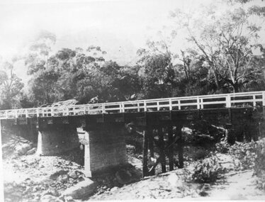
 Orbost & District Historical Society
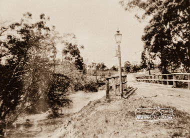
black and white photograph, 1976
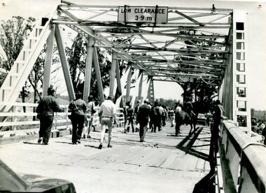
This bridge over the Snowy River was opened on July 4 1922. It was constructed in 1922 alongside the previous suspension bridge. Its building was a combined effort of the Victorian Railways and the Country Roads Board at a cost of 35,000 pounds. It was replaced in 1976 by the present bridge after several major floods. This photograph shows people walking over the bridge for the last time.This is a pictorial record of the former Snowy River Bridge at Orbost.A black / white photograph showing a group of people walking across a bridge. There are several cars, a man on a horse and people standing on the side of the roadway.on back - "1976 - old bridge"snowy-river-bridge-1976 -
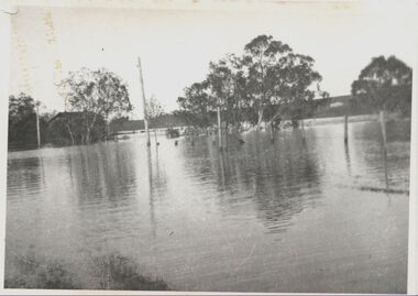
 Kew Historical Society Inc
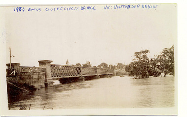
Photograph, Flooding of the Outer Circle Railway Bridge, 1934
One of three digital copies of flooded areas of Kew (1923-34), donated by Jan Coutts of Bulleen in 2019. The handwriting on the originals predates the copy.1934 FLOODS / OUTER CIRCLE BRIDGE / WE WENT UNDER BRIDGE OUTER CIRCLE BRIDGE / 1934 FLOODS / (DAD & I) / WE TOOK OUR CANOE UNDER THE BRIDGE, & CARL SIERAKOSKI WAS IN HIS CANOE AT THE TIME & WROTE DADS NAME A. LUCKE UNDER THE TOP OF THE BRIDGE / NEE (MARY LUCKE) NOW TYACKfloods - kew - 1934 -
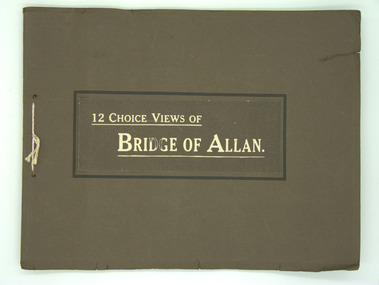 Lara RSL Sub Branch
Booklet, Bridge of Allan, Circa 1960
Returned by J.W.McIntyre after WW1. Rectangular shaped Booklet. Coffee Brown in colour with two holes punched in it along the spine with a white cord tied through the holes.12 Choice Views of Bridge of Allan. -
 Kew Historical Society Inc
Photograph, Willsmere Bridge, 1934
Several boathouses were built in Kew and Fairfield in the late 19th and early 20th centuries. They included Chipperfield’s ‘Moorings’ and floating pontoon. The substantial two-storey house was named the Moorings, and incorporated an upper storey residence. The Moorings was almost washed away in the 1916 floods, and in 1934 almost totally submerged when the Yarra River rose 26 feet in 14 hours. Following the 1934 flood, the house was restored. The floating pontoon, sometimes referred to as a ‘kiosk’ or ‘canteen’, was used to store canoes. Both were removed in 1972 for the construction of the Eastern Freeway.This work forms part of the collection assembled by the historian Dorothy Rogers, that was donated to the Kew Historical Society by her son John Rogers in 2015. The manuscripts, photographs, maps, and documents were sourced by her from both family and local collections or produced as references for her print publications. Many were directly used by Rogers in writing ‘Lovely Old Homes of Kew’ (1961) and 'A History of Kew' (1973), or the numerous articles on local history that she produced for suburban newspapers. Most of the photographs in the collection include detailed annotations in her hand. The Rogers Collection provides a comprehensive insight into the working habits of a historian in the 1960s and 1970s. Together it forms the largest privately-donated collection within the archives of the Kew Historical Society.A view of flooded areas in North Kew in the flood of 1934.Willsmere Bridge. Chipperfields. 1934 floodwillsmere, flood, yarra flood, chipperfields, chipperfields boathouse, north kew -
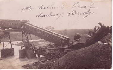 Clunes Museum
photograph, 1909
PHOTOGRAPH OF McCALLUMS CREEK RAILWAY BRIDGE, TRAIN DISASTER 19 TH. AUGUST 1909 ON MARYBOROUGH - BALLARAT LINEORIGINAL PHOTOGRAPH OF RAILWAY BRIDGE COLLAPSE OVER McCALLUMS CREEK, ON AUGUST 19TH. 1909McCALLUMS CREEK RAILWAY BRIDGE.local history, document, postcard, railway -
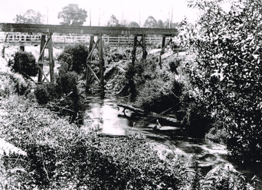 Otway Districts Historical Society
Photograph, Knox Collection, Railway Bridge over Gellibrand River, 1902
Railway bridge over the Gellibrand River, 1902. Note the people on the roadway bridge in the top left corner. B/W.colac; beech forest; gellibrand; railway; -
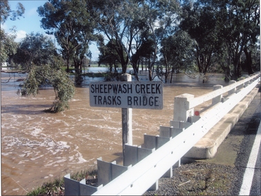 Stawell Historical Society Inc
Photograph, Trasks Bridge at Sheepwash Creek at Campbells Bridge in flood 2011
Trasks Bridge Sheepwash Creek at Campbells Bridge in flood 2011.stawell shire -
 Whitehorse Historical Society Inc.
Photograph, Deep Creek Road Bridge, 18/04/2001 12:00:00 AM
Coloured photograph looking East from Deep Creek Road Bridge at start of construction of new Deep Creek Road Bridge.deep creek road, mitcham, vicroads -
 Stawell Historical Society Inc
Photograph, Delley's Bridge near Hallps Gap -- replaced by a newer bridge
Halls Gap Delley's Bridge. The bridge in the photograph has been replaced.stawell -
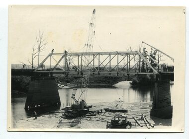 Orbost & District Historical Society
black and white photographs, 1977
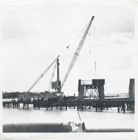
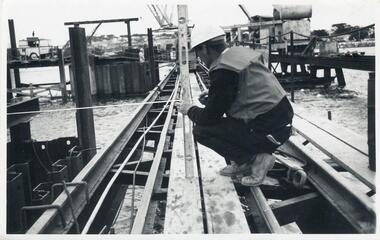
This is a series of photographs of the demolition of the 1922 bridge across the Snowy River at Orbost. This bridge over the Snowy River was opened on July 4 1922. It was constructed in 1922 alongside the previous suspension bridge. Its building was a combined effort of the Victorian Railways and the Country Roads Board at a cost of 35,000 pounds. It was replaced in 1976 by the present bridge after several major floods.This bridge was replaced in 1976 after several major floods. These photographs record the demolition of that bridge.Ten black / white photographs of a road bridge demolition. In the photographs are cranes, one on a barge, and workmenon back - Orbost Snowy River Bridge demolition 1977 -
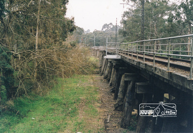 Eltham District Historical Society Inc
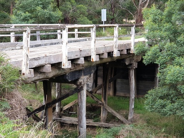
Photograph, Trestle Bridge, Eltham
Colour photograph of the Eltham trestle bridgeeltham, trestle bridge, bridges -
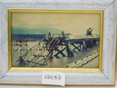 National Vietnam Veterans Museum (NVVM)
Photograph, Damaged Bridge
Framed coloured photo of a damaged bridgephotograph, bridge -
 Stawell Historical Society Inc
Slide, Ian McCann, Wimmera River Bridge at Joel 1957, 1957
Wimmer River Bridge at Joel 1957wimmera river, joel area, joel bridge