Showing 185209 items
matching melbourne-zoological-gardens
-
 Slovenian Association Melbourne
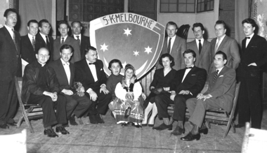
Slovenian Club Melbourne Committee members 1958, Slovenian Club Melbourne Committee members with the coat of arms 1958, 1958
It was a memorable moment when the Slovenian Club Melbourne Coat of Arms was introduced to use on the letterheads, badges and invitations. It represents the Slovenian community under the Southern Cross.Coat of Arms of the Slovenian Club MelbourneBlack and white photo of the Committee members of the Slovenian Club Melbourne in 1958. They are photographed with the Slovenian Club Melbourne Coat of Arms.Slovenian Club Melbourne Coat of Armscoat of arms of slovenian club melbourne, slovenians, southern cross -
 Stawell Historical Society Inc
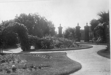
Photograph, Central Park Gardens
... Central Park Gardens ...Black & White Photo Central Park Gardens looking towards gates from near No 1 Grandstand. Photo located in Griffin Album Cat. no 1254 page 25. Black & White Photograph of Central Park Gardens. Photo looking towards the entrance gates, Lower Main St.stawell -
 Melbourne Tram Museum
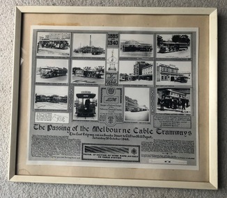
Photograph - Framed, Melbourne & Metropolitan Tramways Board (MMTB), "The passing of the Melbourne Cable Tramways", 1940
"The passing of the Melbourne Cable Tramways", featuring photographs of first cable tram, Fitzroy power house, cable trams in the street, Nicholson St, the No. 1 tram entering the National Museum, some historic notes on the construction of the system, its operations, MMTB takeover, a drawing of the grip and of the badges and buttons used and an image of the cable used. Notes that it was compiled by A. R. Turnbull with co-operation of F. King, K.L.Mackenzie and H. G de Mamiel. Original poster prepared by the MMTB and presented to the State Library or the Museum of Victoria at the time of closure. See Reg Item 6367 for another photograph and 6368 for another poster of the time - Melbourne tramways past and present posterYields information about the Melbourne cable tram system and its history. Frame - wooden outside painted white, glazed with clear glass, off white card backing with brown paper on rear, brass wire hanging wire with small eye hooks the side., containing a photo titled "The passing of the Melbourne Cable Tramways"tramways, cable trams, melbourne, tramcars, closure, museums -
 University of Melbourne, Burnley Campus Archives
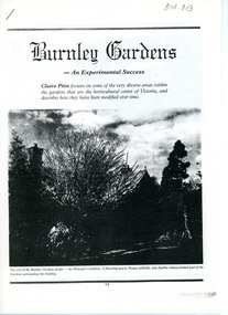
Article, Claire Pitts, Burnley Gardens - an Experimental Success, c. 1991
... Burnley Gardens - an Experimental Success ...5 pages of an article from "The Australian Garden Journal" written by Claire Pitts, Vol 10 No 2 Dec 1990 / Jan 1991. The summary at the introduction to the article states "Claire Pitts focuses on some of the very diverse areas within the gardens that are the horticultural centre of Victoria, and describes how they have been modified over time." Illustrations included Claire Pitts graduated 1986, Burnley Horticultural College, Associate Diploma Horticulture (Perhaps she has done the degree since then?)5-page article by Claire Pitts from Garden Journal, Vol. 10, No. 2, Dec, 1990-Jan. 1991claire pitts, garden journal, diverse gardens victoria, associate diploma of horticulture, burnley gardens, change in victorian gardens -
 Buninyong & District Historical Society
Photograph - B/W photograph, Clive Brooks, Old Swimming Baths, Buninyong Botanic Gardens, 19 July 1993
... Old Swimming Baths, Buninyong Botanic Gardens ...Shows first stage of restoration of old swimming baths, and conversion to enclosed garden.B/W photo of old Swimming Baths in Buninyong Botanic Gardens, constructed by Shire Engineer C P Wilson c 1919 around existing pool.buninyong, swimming baths, botanic gardens, c p wilson -
 Buninyong & District Historical Society
Photograph - B/W photograph, Clive Brooks, Old Swimming Baths, Buninyong Botanic Gardens, 18 September 1993
... Old Swimming Baths, Buninyong Botanic Gardens ...Shows first stage of restoration of old swimming baths, and conversion to enclosed garden.B/W photo of old Swimming Baths in Buninyong Botanic Gardens, constructed by Shire Engineer C P Wilson c 1919 around existing pool.buninyong, swimming baths, botanic gardens, c p wilson -
 Eltham District Historical Society Inc
Photograph, Lunch in Fitzroy Gardens, Melbourne City excursion, 12 April 1987, 12/04/1987
... Lunch in Fitzroy Gardens, Melbourne City excursion, 12 ...Two colour photographsactivities, fitzroy gardens -
 Ringwood and District Historical Society
Photograph, Ringwood High School students pictured with Governor of Victoria, Sir Dallas Brookes at the Melbourne Treasury Gardens Herald-Sun Art Show - 1963
... Victoria, Sir Dallas Brookes at the Melbourne Treasury Gardens ...Written on back of picture, "Ringwood High Magazine". No mention of the occasion or the people in the picture. -
 Horsham Regional Art Gallery
Photograph, Norman DECK, In the Treasury Gardens, Melbourne, 1904
... In the Treasury Gardens, Melbourne ...Purchased through the Horsham Art Gallery Trust Fund with the assistance of the Caltex-Victorian Government Art Fund, 1979 -
 University of Melbourne, Burnley Campus Archives
Article - Photocopy, Trees of the historic Burnley Gardens, Melbourne, Australia, 1891-1948
... Trees of the historic Burnley Gardens, Melbourne, Australia ...Article by D. F. Aldous from Arboricultural Journal [UK] 1990, Vol. 14burnley gardens, d.f. aldous, arboricultural journal, trees -
![Plan, University of Melbourne Burnley Campus Institute of Land and Food Resources Formerly known as the Royal Horticultural Gardens Burnley [sic], 2001](/media/collectors/52f2d90c9821f4163875a333/items/6145823c174069677c22f6e6/item-media/65ef8feeb2201fddf6999498/item-fit-380x285.jpg) University of Melbourne, Burnley Campus Archives
University of Melbourne, Burnley Campus ArchivesPlan, University of Melbourne Burnley Campus Institute of Land and Food Resources Formerly known as the Royal Horticultural Gardens Burnley [sic], 2001
... Gardens Burnley [sic] ...site plan, buildings, planrs -
University of Melbourne, Burnley Campus Archives
Newspaper - Newspaper Cutting, The Age, Alumna turns Burnley Gardens Canteen into a Melbourne favourite, 2011
... Alumna turns Burnley Gardens Canteen into a Melbourne ...Article in The Age 09.05.2011 by Lieu Thi Pham about Tansy Good and the café she runs at Burnley Campus. She is a Burnley Graduate.the age, canteen, lieu thi pham, tansy good, burnley campus -
 Friends of Ballarat Botanical Gardens History Group
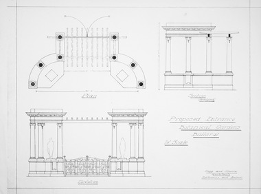
Plan - Proposed Entrance to Gardens; Clegg and Morris Architects, Melbourne and Ballarat
... Proposed Entrance to Gardens; Clegg and Morris Architects ...Shows proposed elevations and sections of proposed structureHistoricPhotocopy ballarat botanical gardens, buildings, plan, entrance -
 Friends of Ballarat Botanical Gardens History Group
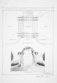
Plan - Suggestion for Entrance to Gardens; Clegg and Morris Architects, Melbourne and Ballarat
... Suggestion for Entrance to Gardens; Clegg and Morris ...HistoricPhotocopy ballarat botanical gardens, buildings, plan, entrance -
University of Melbourne, Burnley Campus Archives
Plan, Royal Botanic Gardens Melbourne, 1978
... Royal Botanic Gardens Melbourne ...Plan of RBG with grid references. Produced by Dept. of Crown Lands and Survey, Victoria, Division of Survey and Mapping. Prepared in 1978 from surveys completed in 1976. (1) 2 copies plan. Main areas, buildings, etc., labelled, beds outlined. (2) Original coloured plan and reduced size photocopy. More labelling, particularly beds (handwritten). Labelled Jeremy J. Wallace with handwritten notes on reverse re a project. (3) Reduced size photocopy. Handwritten labelling of beds. (4 - 11) Enlarged photocopies of sections of (1) Handwritten notes and plant labelling. (1). Photgraphed copies by FRESCO 510131-TA. (12) Plan on a grid, coloured. "No Public Access," areas marked.jeremy j. wallace, royal botanical gardens melbourne, department of crown land and survey division of survey and mapping, ornamental lakes -
University of Melbourne, Burnley Campus Archives
Booklet, Chi Baik et al, The Melbourne Sessional Teachers' Handbook, 2011
teaching, sessional teaching, chi baik, advice, strategies, university of melbourne -
 Melbourne Tram Museum
Document - Memorandum, Melbourne & Metropolitan Tramways Board (MMTB), Warships at Port Melbourne, Oct. 1934
HM & HMA Ships Sussex, Dunedin, Diomede, and Canberra at Princes Pier, Port Melbourne during Centenary Celebrations Saturday 20 October to Sunday 11 November 1934 1 - Handwritten note "Warships at Princes Pier Port Melbourne Sat 20th Oct to Sun 11th Nov" 2 - Handwritten note "Warships at Port Melbourne " - Insp Blyth's report on tramcar loadings for Sunday 11 November. 3 - Port Melbourne Cable Line - memo from DJ Davidson, Dist Traffic Superintendent SS to Mr Taylor at South Melbourne outlining running times for cable trams to Port Melbourne 4 - Handwritten table card 5 - Letters from Navy Office proving details of ship opening times during the Royal VisitNumerous inscriptions written in pencil and ink across most documentstrams, tramways, events, inspection, port melbourne, port melbourne depot, cable trams -
 Friends of Ballarat Botanical Gardens History Group
Work on paper - "Claxton Monument is back to its best." Ballarat Courier, 15/8/97 and the launching of a computerised labelling system of trees and plants in the Gardens, The Recommissioning of the Monument in the Ballarat Botanical Gardens and the Engraving of the first tree label, 15/8/1997
... Botanical Gardens and the Engraving of the first tree label....Gardens ...The Claxton Monument and Fountain in the Ballarat Botanical Gardens was recommissioned in 1997 after extensive renovations and a computerised engraving system was purchased for the labelling of plants.The Claxton Monument is an important part of Ballarat Botanical Gardens historic statuary. And the new labelling system would help preserve part of City's history.I page (p.5) of yellowed newsprint with a large black and white photograph of the Claxton Monument to the right hand side. Cut out of newspaper at the bottom.At the top of the page, written in blue biro: "10.30 am 15/8/97 - Joan Garner - President attended by 50 Friends and Garden Staff."john garner, doctor, ballarat botanical gardens, friends of the ballarat botanical gardens, claxton monument, restoration, frederick moses claxton, mayor, computerised labelling system, claxton, john garner collection, gardens, ballarat, courier -
 Port Fairy Historical Society Museum and Archives
Postcard
Entrance to Gardens - Port Fairy. The Port Fairy Botanical Gardens were formed in 1856 making it one of the earliest gardens in Victoria. The first curator was James Prior, he was paid fifty-two pounds per annum. He was an outstanding curator having been apprenticed to the trade in England at the age of 12, his brother Edward in later years was the Curator of the Koroit Gardens. Prior retired in 1903. During the years of his curatorship Port Fairy was said to have the best gardens outside the city of Melbourne, he was constantly in touch with Baron Von Mueller and later Guilfoyle of the Royal Botanical Gardens of Melbourne. In the early years plants from all over the world were planted here with varying rates of success many of them sent by Baron Von Mueller. In the 1930’ and 40’s the gardens were still very beautiful, and the curator was Roy Manuell. The beautiful iron gates at the entrance were destroyed in the 1946 floods and were replaced in 1989 using some of the material from the original gates. From the 1950’s on the gardens went into a state of decline, much being taken up by the caravan park until in 1986, after a public meeting ‘Friends of the Gardens’ was founded when the entrance section was restored. Hand painted photograph of winding path in Botanical GardensGardens Port Fairythe gardens, gates, botanical, griffith street -
 Vision Australia
Certificate - Text, RVIB 125th anniversary greetings from Melbourne Lord Mayor Richard Wynne, 1991
Letter offering congratulations and future success to the RVIB on behalf of the Lord Mayor of Melbourne on the occasion of the RVIB's 125th anniversary in 1991. Signed by the Lord Mayor of Melbourne, Richard Wynne.1 letter from the Melbourne Lord MayorSeal of the Lord Mayor Melbourne, with two ribbons, is affixed to the bottom right hand corner The Crest of the Melbourne Lord Mayor's Office in the top centre of the page.royal victorian institute for the blind, richard wynne -
Port Melbourne Historical & Preservation Society
Newspaper - Cutting, Tyro, Garden Fete at Port Melbourne, 4 Mar 1909
Newspaper cutting dated March 4, 1909 - Caption reads "Garden Fete at Port Melbourne. The incumbent of Holy Trinity Church (Rev H Stanley HOLLOW), Mrs H.S. HOLLOW, The Mayor of Port Melbourne and Mrs A. ROGERS, Mrs J RENDALL, and committee and workers for the Garden Fete in aid of rebuilding Holy Trinity Church, Port Melbourne." Cutting has been pasted onto large red cardboard.Hand written above the caption is "Mrs Crockford, Mrs Howe, Mrs Rendall, Mrs Hollow, Mrs Rogers, Mrs George, Mrs Glen Knight"celebrations fetes and exhibitions, religion - anglican (holy trinity), herbert stanley hollow, mrs hollow, mayors, mrs rogers, jane rendall nee harrison, mrs crockford, mrs george, mrs glen knight, alexander rogers, mrs w howe -
 Stawell Historical Society Inc
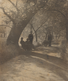
Photograph, Central Park Gardens c1908, c1908
... Central Park Gardens c1908 ...Central Park Gardens. Postcard c1900 showing three children. Two Girls at right and a boy at center of photo3 Postcards 2 colored of Central Park Stawell showing 3 childen 2 females under arch way and one male on path in gardens.One of the colored Post cards is addressed to Miss Roney Hartey 95 Thompson St Williamstown from Min. Date on stamp Oct. 27 1908 and posted in Stawell.stawell -
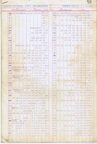 Melbourne Tram Museum
Administrative record - Depot Table Sheet or Block, Melbourne & Metropolitan Tramways Board (MMTB), North Fitzroy - Port Melbourne, Jan. 1968
Depot table sheet - 5 pages printed on light weight card paper, foolscap size or block - roneo or spirit - spirit duplicated - giving the weekday bus timetable for Bulleen to Garden City in both directions. Gives run number, departure times and the return destination. Dated 24 May 1965. 1413.1 - Email from Kevin Staines to Warren Doubleday 6/5/2016 commenting on being a bus driver at Port Melbourne Depot. Added 19-11-2016trams, tramways, table cards, north fitzroy depot, drivers, bulleen, buses -
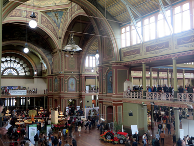 Ballarat Heritage Services
Photograph -Colour, Clare Gervasoni, Interior of the Melbourne Exhibition Building, 2019, 31/03/2019
A competition was announced to design a suitable building for the proposed Melbourne International Exhibition in December 1877. Eighteen entries were received. The winner of 300 pounds was Joseph Reed of the architectual firm Reed and Barnes. The foundation stone was laid by Governor Sir George Bowen on 19 February 1879. Prominent Melbounre builder David Mitchell, father of Dame Nellie Melba, won the tender to construct the main building. Exhibitors were able to move in by May 1880. On 01 October 1880 the Melbourne International Exhibition opened, when over 6000 people entered the main hall to see the Governor, the Marquess of Normanby open the show. Thirty three nations participated and ofver 32,000 exhibits were displayed. At the close of the exhibition on 30 April 1881 over 1.3 million people had visited the exhibition. In 1881 Victoria's population was just over 250,000. The management of the Exhibition Building and eight hectares of the Carlton Gardens was handed to the Exhibition Trustees by the Melbourne International Exhibition Commissioners on 01 OCtober 1881. The Trustees maintained the building for 'future public exhibitions and ... general public instruction and recreation' until 1996 when management of the building was transferred to Museum Victoria. In 1901 when the Australian colonies federated there was no capital and no federal parliament building. The Federal Parliament moved into the Victorian State Parliament building, and the State Parliament moved into the Western Annexe of the Exhibition Building for 26 years. After World War One, on 04 February 1919, the exhibition Building was turned into a hospital to treat Melbournians struck down with the Spanis 'Flu'. Initially housing 500 beds, the hospital grew to accomodate 2000 patients. Femals were located between the concert platform in the western nave and the done; male patients occupied the spaces beyond. The basement was used a a morgue. With the departure of the State Parliament in 1927 the western annexe became home to the Country Roads Board. In 1932 it was joined by the MOtor Registration Branch, and the Transport Regulation Board in 1934. They co-existedin cramped offices until the 1960s. In 1949 the oval at the rear of the ExhibitionBuilding was leased to the Commonealth Government for the establishment of the Migrant Reception Centre. When it closed in 1961-62, the centre comrised 29 bungalows over 1.4 hectare. The centre provided temporary accomodation for thousands of new arrivals from Britain. On 01 July 2004 the Royal Exhibition Building and Carlton Gardens were inscribed on the World Heritage List. It is the only 19th century Great Hall to survive largely intact, still in its original landscape setting, and still used as a palace of industry. The Melbourne International Flower and Garden Show is a flower show held annually since 1995 in early April each year, in Melbourne, Australia. It is located in the World Heritage Site of Carlton Gardens and the Royal Exhibition Building.[1] It is the largest horticultural event in the southern hemisphere, attracting over 100,000 visitors. It is rated among the top five flower and garden shows in the world. (Wikipedia)Colour photograph of the interior of the Melbourne Exhibition Buildings during the 2019 Melbourne Flower and Garden Show. Four mottoes are painted under teh windows of the dome: Dei Grecia (By the grace of God), Carpe diem (Make the most of the day), Aude sapere (Dare to be wise) and Benigno numine (With benighn power)melbourne international flower and garden show, carlton gardens, melbourne exhibition building, royal exhibition buildings -
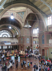 Ballarat Heritage Services
Photograph - Photograph -Colour, Clare Gervasoni, Interior of the Melbourne Exhibition Building, 2019, 31/03/2019
A competition was announced to design a suitable building for the proposed Melbourne International Exhibition in December 1877. Eighteen entries were received. The winner of 300 pounds was Joseph Reed of the architectual firm Reed and Barnes. The foundation stone was laid by Governor Sir George Bowen on 19 February 1879. Prominent Melbounre builder David Mitchell, father of Dame Nellie Melba, won the tender to construct the main building. Exhibitors were able to move in by May 1880. On 01 October 1880 the Melbourne International Exhibition opened, when over 6000 people entered the main hall to see the Governor, the Marquess of Normanby open the show. Thirty three nations participated and ofver 32,000 exhibits were displayed. At the close of the exhibition on 30 April 1881 over 1.3 million people had visited the exhibition. In 1881 Victoria's population was just over 250,000. The management of the Exhibition Building and eight hectares of the Carlton Gardens was handed to the Exhibition Trustees by the Melbourne International Exhibition Commissioners on 01 OCtober 1881. The Trustees maintained the building for 'future public exhibitions and ... general public instruction and recreation' until 1996 when management of the building was transferred to Museum Victoria. In 1901 when the Australian colonies federated there was no capital and no federal parliament building. The Federal Parliament moved into the Victorian State Parliament building, and the State Parliament moved into the Western Annexe of the Exhibition Building for 26 years. After World War One, on 04 February 1919, the exhibition Building was turned into a hospital to treat Melbournians struck down with the Spanis 'Flu'. Initially housing 500 beds, the hospital grew to accomodate 2000 patients. Femals were located between the concert platform in the western nave and the done; male patients occupied the spaces beyond. The basement was used a a morgue. With the departure of the State Parliament in 1927 the western annexe became home to the Country Roads Board. In 1932 it was joined by the MOtor Registration Branch, and the Transport Regulation Board in 1934. They co-existedin cramped offices until the 1960s. In 1949 the oval at the rear of the ExhibitionBuilding was leased to the Commonealth Government for the establishment of the Migrant Reception Centre. When it closed in 1961-62, the centre comrised 29 bungalows over 1.4 hectare. The centre provided temporary accomodation for thousands of new arrivals from Britain. On 01 July 2004 the Royal Exhibition Building and Carlton Gardens were inscribed on the World Heritage List. It is the only 19th century Great Hall to survive largely intact, still in its original landscape setting, and still used as a palace of industry. The Melbourne International Flower and Garden Show is a flower show held annually since 1995 in early April each year, in Melbourne, Australia. It is located in the World Heritage Site of Carlton Gardens and the Royal Exhibition Building.[1] It is the largest horticultural event in the southern hemisphere, attracting over 100,000 visitors. It is rated among the top five flower and garden shows in the world. (Wikipedia)Colour photograph of the interior of the Melbourne Exhibition Buildings during the 2019 Melbourne Flower and Garden Show. Four mottoes are painted under teh windows of the dome: Dei Grecia (By the grace of God), Carpe diem (Make the most of the day), Aude sapere (Dare to be wise) and Benigno numine (With benighn power)melbourne international flower and garden show, carlton gardens, melbourne exhibition building, royal exhibition buildings -
 Melbourne Tram Museum
Document - Report, Melbourne & Metropolitan Tramways Board (MMTB), 'Current trends which may indicate the future growth and nature of the metropolitan area and in particular the Central Business area of Melbourne", Jan. 1966
Report - Foolscap, card covers, red binding strip, about pages + drawings or charts, titled 'Current trends which may indicate the future growth and nature of the metropolitan area and in particular the Central Business area of Melbourne" Has three parts: 1 - Future growth of population of the Melbourne Metropolitan Area 2 - The Centre of Gravity of and general distribution of the Central Business area of Melbourne 3 - Future growth of the Central Business Area of Melbourne. Dated Jan 1966, prior to the construction of the Underground Railway and the move to Docklands.Has "JEC" in pencil on top right hand corner.trams, tramways, melbourne, planning, development -
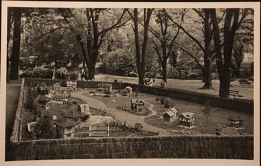 Kew Historical Society Inc
Postcard, Tudor Village, Fitzroy Gardens, 1948-52
... Tudor Village, Fitzroy Gardens ...One of a number of 'real photo' and commercial postcards created by or owned by members of the Christian and Washfold families of Kew. The postcards are part of a larger collection of photographs, postcards and publications donated to the collection in May 2021.Black and white postcard of the miniature village in the Fitzroy Gardens. Printed by Kodak Melbourne, and possibly printed from a photograph by a member of the Christian or Washfold families of Kew. postcards, miniature village -- fitzroy gardens, christian-washfold collection -
Port Melbourne Historical & Preservation Society
Flyer, 1999 Port Melbourne Festival, Feb 1991
Produced by the Port Melbourne Festival Committee and distributed throughout the municipalityYellow flyer promoting vintage films for Port Melbourne Festival 1991: A4arts and entertainment - film/cinema, celebrations fetes and exhibitions, port melbourne festival committee, circus oz -
Clunes Museum
Booklet - HANDBOOK, CITY OF MELBOURNE HANDBOOK 1950-51
PRESENTED TO THE MAYOR OF CLUNES, COUNCILLOR R.A. STEART BY THE LORD MAYOR OF MELBOURNE, COUNCILLOR THE HON. JAMES B. DISNEY, J.P.BLACK HANDBOOK WITH GOLD LETTERING AND MELBOURNE COAT OF ARMS.CITY OF MELBOURNE HANDBOOK 1950-51local history, government, local government, council., -
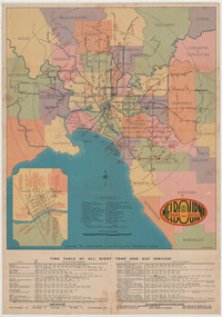 Melbourne Tram Museum
Ephemera - Map - Timetable, Melbourne & Metropolitan Tramways Board (MMTB), "Map and timetable of Melbourne Tram and Bus Services", March 1952
Map provided information about Melbourne's tramway network in 1952. At base of map - timetable of all night trams and bus services. On rear index to routes, 1st and last services, time of Sunday am services, Latrobe St. services and photo of Wattle Park. The conversion of Bourke St to electric trams marked up. Copy 1 - has been marked for hypothetical extensions in blue pencil mainly in the northern and western suburbs. In particular note the Ballarat Road and South Road markings. Copy 2 - has been marked up for newer route numbers, following the opening of the Bourke St services and additional route numbers on the Essendon Depot lines. Demonstrates the provision of information about Melbourne tram services.Fold out map (10 sections - 2 high x 5 wide), coloured of Melbourne's Tram and Bus routes, route numbers, rail lines, municipalities boundaries and location of major places of interest. melbourne, tram and bus services, mmtb, buses, trams, routes, timetables, all night services