Showing 345 items matching "mining geology"
-
 Bendigo Historical Society Inc.
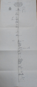
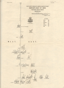
Map - GREAT EXTENDED HUSTLER'S MINE - PLAN OF THE GREAT EXTENDED HUSTLER'S MINE
Plan of the Great Extended Hustler's Mine. Bulletin No 33, Plate No XI. Shows No 2 Shaft, Latham & Watson's Shaft, levels and their depths and some geographical features. Geographical Survey of Victoria emblem and signed by H A Whitelaw, Underground Survey Office, Bendigo, September 1913. Has reference to photos.mining, parish map, great extended hustler's mine, no 2 shaft, latham & watson's shaft, geological survey of victoria, underground survey office bendigo, h a whitelaw -
 Bendigo Historical Society Inc.
Map - FORTUNA HUSTLER'S MINE - TRANSVERSE SECTION OF THE FORTUNA HUSTLER'S MINE
Transverse Section of the Fortuna Hustler's Mine on the Hustler's Line of Reef, Bendigo. Bulletin No 33, Plate No III. Drawing shows poppet legs on the surface and Sill of Shaft 745.38 feet above Sea Level. Shows levels and their depths, geographical features and stone encountered. Reference table to stone and geographical features. Geographical Survey of Victoria emblem. Signed by H A Whitelaw, Underground Survey Office, Bendigo. mining, fortuna hustler's mine, hustler's line of reef, geological survey of victoria, underground survey office bendigo, h a whitelaw -
 Bendigo Historical Society Inc.
Map - FORTUNA HUSTLER'S MINE - LONGITUDINAL SECTION OF THE FORTUNA HUSTLER'S MINE
Longitudinal Section of the Fortuna Hustler's Mine on the Hustler's Line of Reef, Bendigo. Bulletin No 33, Plate No IV. Shows poppet legs at the surface level, Datum Line 750 feet above Sea Level, levels and their depths, the amount of gold per ton and some geographical features. Geological Survey of Victoria emblem and signed by H A Whitelaw, Underground Survey Office, Bendigo. Note - Plates 4, 8, 13, 20, 26 & 31 form a Longitudinal Section from Fortuna Hustler's to Hustler's Consols Mine. mining, parish map, fortuna hustler's mine, longitudinal section of the fortuna hustler's mine, geological survey of victoria, h a whitelaw, underground survey office bendigo, hustler's line of reef, hustler's consols mine -
 Bendigo Historical Society Inc.
Map - FORTUNA HUSTLER'S MINE - PLAN OF THE FORTUNA HUSTLER'S MINE
Plan of the Fortuna Hustler's Mine, Bulletin No 33, Plate No II. Geological Survey of Victoria. Signed by H A Whitelaw, Underground Survey Office Bendigo, September 1913. Map shows levels and depths. There are smaller drawings of some sections of some levels. mining, parish map, fortuna hustler's mine, plan of the fortuna hustler's mine, geological survey of victoria, h a whitelaw, underground survey office bendigo -
 Bendigo Historical Society Inc.
Map - HUSTLER'S REEF MINE - EAST & WEST CROSS-CUTS, NORTH & SOUTH OF SHAFT
East & West Crosscuts, North & South of Shaft, Hustler's Reef Mine Bulletin No 33, Plate No XIX. Map shows main shaft and smaller drawing of section with different stone encountered. Also gives location in relation to the shaft, e. g. 225'E & 150'S of Shaft. Reference diagram to show the different stone and features encountered. Geological Survey of Victoria emblem. Signed by H A Whitelaw, Underground Survey Office Bendigo, September 1913. mining, parish map, hustler's reef mine, east & west cross-cuts north & south of shaft, geological survey of victoria, h a whitelaw, underground survey office bendigo -
 Bendigo Historical Society Inc.
Map - HUSTLER'S REEF MINE - TRANSVERSE SECTION OF THE HUSTLER'S REEF MINE
Transverse Section of the Hustler's Reef Mine on the Hustler's Line of Reefs. Bulletin No 33, Plate No XVIII. Shows cross-cuts and their depth, different types of stone and geological features encountered. Drawing of poppet legs at the surface and Sill of Shaft 756.39 ft above Sea Level. Reference Table shows key to the different stone and geographical features encountered. Geographical Survey of Victoria. Signed by H A Whitelaw, Underground Survey Office, Bendigo, September 1913. Thompson's Reef is also mentioned on the map. mining, hustler's reef mine, transverse section of the hustler's reef mine, geological survey of victoria, h a whitelaw, underground survey office bendigo, thompson's reef. -
 Bendigo Historical Society Inc.
Map - HUSTLER'S CONSOLS MINE - TRANSVERSE SECTION OF THE HUSTLER'S CONSOLS MINE
Transverse Section of the Hustler's Consols Mine Bulletin No 33, Plate No XXXIII. Map shows poppet legs at the surface and Sill of Shaft 779.42 feet above Sea Level. Shows the different levels and their depths and the different stone and geographical features encountered. Has larger drawing of Section A - B. Geographical Survey of Victoria. Signed by H A Whitelaw, Underground Survey Office Bendigo, September 1913. mining, parish map, hustler's consols mine, transverse section of the hustler's consols mine, geological survey of victoria, underground survey office bendigo, h a whitelaw -
 Bendigo Historical Society Inc.
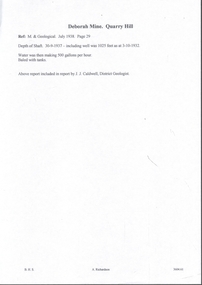
Document - MINING REPORTS - DEBORAH MINE - QUARRY HILL
Handwritten notes from a report by J. J. Caldwell, District Geologist. Ref. M. & Geological, July 1938. Page 29. Depth of Shaft 30 - 9 - 1937 - including well was 1025 feet as at 3 - 10 - 1932. Water was then making 500 gallons per hour. Baled with tanks.document, gold, mining reports, deborah mine quarry hill, m & geological, j j caldwell -
 Bendigo Historical Society Inc.
Letter - MERLE HALL COLLECTION: ROSALIND PARK CREATIVE VILLAGE BENDIGO PROJECT LETTERS, 1994
Merle Hall Collection: Rosalind Park Creative Village Bendigo Project Letters 31 March 1994 To: Victorian Arts Council Members From Grant Finck Project Coordinator Content: Introduces himself as the coordinator for 12 months; to members looking for expression of interest, includes Information Sheet 1994 on what the Creative Village is. 27 October 1995 To: Mrs. Mearle Hall From: City of Greater Bendigo, Bernard Smith (Director Environmental Services) Content: Granting access to the Victoria Hill site for small quantities of geological material. 10 January 1996 To: Mrs. Mearle Hall From: City of Greater Bendigo, Bernard Smith (Director Environmental Services) Content: Endorsement of the project by the Council and confirmation that the Council will provide preliminary site work to allow the project to be enabled. Also advised the Arts Bendigo Mosaic Project makes contact with the Salvation Army (New Work Opportunity Project) 27 February 1996 To: Mrs. Mearle Hall From: Ken Beasley Manager Project Development The Smith Read Training Group. Content: LEAP Project Proposal - Mining Heritage Mosaic outlining the benefits of using LEAP Trainees to undertake the project. Proposed Scope of work outlining responsibilities of each participant. Bendigo Mining NL Environmental Trust Fund (Perseverance Exploration and Department of Energy and Minerals Victoria representatives) 27 June 1996 To: Mrs. Mearle Hall From: City of Greater Bendigo, Bernard Smith (Director Environmental Services) Content: Advising that the Council will match dollar for dollar funding for the engagement of an artist to supervise the construction of the Mosaic in Upper Rosalind Park up to $3,500. 22 July 1996 To: Anne Buzza From Geof Brown Camp Hill Primary School Content: Thanks for using and managing the school students to help create tiles. 9 October 1996 To: Mrs. Mearle Hall From: City of Greater Bendigo, Bernard Smith (Director Environmental Services) Content: Enclosed cheque for matching grant of $3500 15 October 1996 To: Mrs. Mearle Hall From: City of Greater Bendigo, Bernard Smith (Director Environmental Services) Content: Agreement to relocate the project facilities to the car park and to maintain a close liaison between the Council and Arts Bendigo. 13 November 1996 To: Mrs. Mearle Hall From: The Sidney Myer Fund Helen Morris Research Officer Content: Remittance advice for $1000 22 April 1997 To: Mrs. Mearle Hall From: John Little Administrator Victorian Arts Council Content: Remittance advice for $500 towards the project and enclosing 12 VAC Annual reports. 20 October 1998 To: Mrs. Mearle Hall From: City of Greater Bendigo, Andrew Hall (Director Community Development) Content: Advising that the Council will make a grant of $1090 for the purpose of printing of Brochures for Bendigo Heritage Mosaic. A service agreement to be signed before the issue of the grant, 21 March 2001 To: Mrs. Mearle Hall From: City of Greater Bendigo, Justin Hanney (Director Community Services) Content: A reference from Council supporting the project application to Vic Health for the development of a series of small mosaic pieces along the linear pathway asjacent to the Bendigo Creek. 12 November 1996 To: Mrs. Mearle Hall From: Arts Bendigo Inc. Content: Cheque for $2000 being first payment as under contract two for mosaic project. 4 December 1996 To: Mrs. Mearle Hall From: Arts Bendigo Inc. Content: Cheque for $2000 being second payment as under contract two for mosaic project. 27 July 1997 To: Maery Gabriel Mosaic Artist From: Arts Bendigo Inc. Content: Cheque for $2000 being final payment as under contract two for mosaic project. 12 June 1997 - Two copies To: Maery Gabriel Mosaic Artist From: Arts Bendigo Inc. Content: Agreement between Maery Gabriel (The artist) and Arts Bendigo Inc. to complete the final two sections of the Bendigo Heritage Mosaic at the base of the Rosalin Park Poppet Head, Bendigo with a design of approximately two square meters within each section. The work to be completed by the endo of July 1997, unless severe weather conditions make the laying impossible. Agreement for two lots of $2000. 14 June 1996 From: Maery Gabriel Mosaic Artist To: Arts Bendigo Inc. Content: receipt for 50% payment for two weeks and $60 Travelling expenses. 21 May 1996 Agreement between Arts Bendigo of P.O Box 563, Bendigo in the State of Victoria (hereinafter referred to as the ‘AB’ of the first part AND Meary Hall of Morningswood, Petersons Road, Ellinbank, 3821 in the State of Victoria (hereinafter referred to as ‘the artist’) of the second part. ENGAGEMENT: (a) AB engages the Artist to provide her services as Mosaic Artist for the design and creation of a Mosaic pavement surround to the poppet head lookout in Rosalind Park, Bendigo and matters incidental thereto at such schools, halls and any other places as required from time to time by AB and the Artist accepts the engagement upon the term and conditions hereinafter appearing. (b) Services to be provided by the artist include community consultation and design work in association with AB Co-Ordinator and Arts Bendigo, a minimum of six weeks of the artist’s time within the six months of the project. Completion of section one of the whole design with further work on the other sections to depend on available funding. The agreed fee was $5400 and $60 per visit to Bendigo with living away to be provided by Arts Bendigo 1 November 1996 Agreement between Arts Bendigo of P.O Box 563, Bendigo in the State of Victoria (hereinafter referred to as the ‘AB’ of the first part AND Meary Hall of Morningswood, Petersons Road, Ellinbank, 3821 in the State of Victoria (hereinafter referred to as ‘the artist’) of the second part. ENGAGEMENT: (a) AB engages the Artist to provide her services as Mosaic Artist for the design and creation of a Mosaic pavement surround to the poppet head lookout in Rosalind Park, Bendigo and matters incidental thereto at such schools, halls and any other places as required from time to time by AB and the Artist accepts the engagement upon the term and conditions hereinafter appearing. (b) Services to be provided by the artist include community consultation and design work in association with AB Co-Ordinator and Arts Bendigo, a minimum of six weeks of the artist’s time within the six months of the project. Completion of section one of the whole design with further work on the other sections to depend on available funding. The agreed fee was $5000 and $60 per visit to Bendigo with living away to be provided by Arts Bendigo, plus transfer of the diamond saw purchased by AB 28 August 1996 Memorial to Bendigo’s Mining Heritage and Traditions financial and other support as at August 128th Arts Bendigo Financial contribution: $7000 Local Busine Sponsors: $2800 City of Greater Bendigo Matching Above: $2800 City of Greater Bendigo Site works: Equiv, $12000 Local Businesses and institutions supplying goods and services to total value of: Equiv: $7600 Expenditure: Purchase of equipment, including diamond saw: $2000 Purchase of materials: $800 Artists design fees: $3000 Artists on site work, travel and accommodation: $12000 insurance, administration etc.: $700 31 May 1996 List of possible donors' checklist Undated Budget Sheet 21 September 1995 From: The Victorian Arts Council To: City of Greater Bendigo Content: Invoice for $5000 10 December 1995 From: Maery Gabriel artist To: Arts Bendigo Content: Invoice $1575 for design of Rosalind Park Lookout. 45 hours @ $35/hour 1 October 1996 Historic mining Mosaic Pavement, Rosalind Park Poppet Head Financial Statement as a October 1st, 1996 28 October 1996 From: Maery Gabriel To: Ann Buzza (representing Arts Bendigo) Report on project of Rosalind Park Mosaic as at October 1996. The report lists the difficulties faced with the weather, unsuitable facilities on site and problems with the LEAP team labour.victorian arts council, city of greater bendigo -
 Bendigo Historical Society Inc.
Document - Geological Survey of Victoria, Hustlers Line of Reef, Bendigo, April, 2014
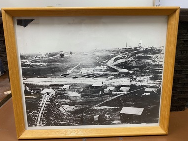
Seven men were killed at the Great Extended Hustler's mine disaster on 2nd May 1914 by an explosion of dynamite occurring as the men were waiting at the plat to ascend the mine at the end of their shift. No blame was attached to anyone in the findings of the inquisition. It was unknown what caused the dynamite to explode. This document formed part of the research done at the time by Bendigo Historical Society, of the 100 years commemoration of the mine disaster, held at Hustler's Hill in 2014. Seven page photocopy of Department of Mines, Bulletin, Geological Survey of Victoria, Hustlers Line of Reef, Bendigo, No. 33 by H.S. Whitelaw. Includes plan of Hustlers Royal Reserve No. 2, (main shaft) showing location on Pall Mall, and location of Post Office and Law Courts; plan of location of Hustlers Royal Reserve No. 2 (Park Shaft) showing Jail (sic), Camp Hill State School, two 'lagoons' in between tennis court, croquet court and bowling green; a plan of the Great Extended Hustler's Shaft and two copied images of Hustler's Hill showing mining buildings, poppet heads and chimneys. Comet, K.K., Hustler's No. 1, Old Comet and United Hustler's and Redan Mines are shown in the images. great extended hustlers, goldmining, accident, quartz, mining, k.k. mine, comet mine, hustler's line of reef, old comet, united hustler's, redan -
 Clunes Museum
Photograph, ca1861
When Richard Daintree rejoined the Victorian Geological Survey as a field surveyor in January 1859, he pioneered the use of photography in field-work. The glass plates attributed to him by the State Library of Victoria show four images of the mines in Clunes, Victoria, Australia in the 1860'sBlack and white reproduction of Port Phillip Colonial & Gold Mining Co., Clunes, Victoria, Australia in a light wood timber frameOn Reverse: Handwritten in pencil Port Phillip Co. 1860's Nettleton Photography glass plate Latrobe Libraryport phillip and colonial gold mining co., richard daintree -
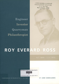 Narre Warren and District Family History Group
Book, Jane Sandilands, Roy Everard Ross, 6.7.1899-1.11.1970 : engineer, investor, quarryman, philanthropist, 2003
For 25 years of his working life he worked as a Shire Engineer in West Gippsland and developed a reputation for competence and efficiency. Passionate about both trees and golf, he was a careful and measured man with an entrepreneurial spirit who worked behind the scenes He was seen by many as aloof and a hard man and by the very few who became close to him, as warm and fun loving and fond of children. Ross formed a business association with Wally Lawson in Warragul and together they embarked on a number of projects to advance the town and the district. As a young man, Ross had studied geology and working with quarries was familiar to him in his role as a Shire Engineer. In 1959 he established Bayview Quarries in partnership with Wally Lawson. When, in 1968, Bayview Quarries was taken over by Boral Ltd., Ross approached Tom Maw who had an operational quarry at Dromana on the Mornington Peninsula. Ross and Maw became partners in what became Hillview Quarries. Ross also became the largest individual shareholder in Western Mining. Those shares formed the major part of the legacy he left to establish The R. E. Ross Trust and The Trust now operates on its income from assets acquired following the disposal of the Western Mining shares and from the earnings of Hilhnew Quarries. It is the only trust in Australia which owns a quarry as one of its investments.non-fictionFor 25 years of his working life he worked as a Shire Engineer in West Gippsland and developed a reputation for competence and efficiency. Passionate about both trees and golf, he was a careful and measured man with an entrepreneurial spirit who worked behind the scenes He was seen by many as aloof and a hard man and by the very few who became close to him, as warm and fun loving and fond of children. Ross formed a business association with Wally Lawson in Warragul and together they embarked on a number of projects to advance the town and the district. As a young man, Ross had studied geology and working with quarries was familiar to him in his role as a Shire Engineer. In 1959 he established Bayview Quarries in partnership with Wally Lawson. When, in 1968, Bayview Quarries was taken over by Boral Ltd., Ross approached Tom Maw who had an operational quarry at Dromana on the Mornington Peninsula. Ross and Maw became partners in what became Hillview Quarries. Ross also became the largest individual shareholder in Western Mining. Those shares formed the major part of the legacy he left to establish The R. E. Ross Trust and The Trust now operates on its income from assets acquired following the disposal of the Western Mining shares and from the earnings of Hilhnew Quarries. It is the only trust in Australia which owns a quarry as one of its investments.engineering, philanthropy, quarryman, investor, r.e. ross trust, hillview quarries, wally lawson, roy everard ross -
 The Beechworth Burke Museum
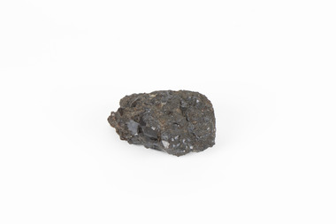
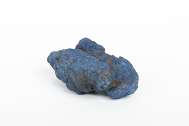
Geological specimen - Garnet crystals in galena, Unknown
Majority of Galena in Australia is found in hydrothermal deposits emplaced around 1680 million years ago which have been heavily metamorphosed. Galena is the natural mineral form of lead sulfaide. It occurs generally as fine to large crystals due to syntectonic remobilization at low temperatures and moves to a suitable location. The colour is a shining lead and silvery gray with high specific gravity between 7.2 and 7.6 gms/cm3 and contains 86.6 lead sulfaide in its purest form. Its cyrstal system is cubic with perfect cleavages, and contract penetration and lamellar twinning. This particular specimen is from the Broken Hill mine, it is one of the largest lead mines located in Western New South Wales and still has ore reserves amounting to 20.9 million tonnes of ore grading of 7.4% lead, 9.4% zinc, and 61.5 million oz of Silver. Throughout its history, it has produced over 200 million tonnes of ore throughout its 127 years of mining history dating back to 1885. Galena mineral ore found in Australia is considered rare, as it is only currently found in the Broken Hill Mine of Western New South Wales. It represents heritage value through the systematic collecting of the geological surveyers in Victoria and Australia during the early to late 19th Century. The fact that it is only found in one mining area of Australia, shows that this specimen is rare for examples of Australian Galena. This mineral specimen is one part to a larger collection, aquistion, and distribution of Garnet in Galena around Australia and parts of the world and donated to the Burke Museum between 1860-1880. While this specimen was not found by the Victorian Geological Survey, it shows the historical need for mapping geological areas around the Gold Rush region to further identify areas of precious metal and gem aquisition. Additionally, collecting these specimens was an important part of mapping the scientific make up of the earth's surface. Many were sent to institutions for further contribution to research and scientific knowledge of the specimens. A solid coin-sized lead and zinc sulphaide and zinc silicate ore mineral in shades of black and red with shiny black points. GARNET CRYSTALS in / GALENA (lead sulphide), / SPALERITE (zinc sulphide), / WILLEMITE (zinc silicate) ore. / Locality: Broken Hill, NSWburke museum, #beechworth, indigo shire, beechworth museum, geological, geological specimen, mineral, galena, galena quartz, broken hill mine, broken hill, nsw -
 The Beechworth Burke Museum
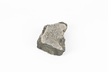
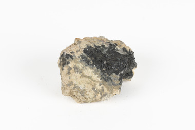
Geological specimen - Pyrite crystals in black slate, Unknown
Pyrite also known as iron Pyrite or fools gold is an iron sulfide with a chemical formula of FeS2 and is the most abundant sulfide mineral. Its metallic luster and pale brass-yellow hue give it a superficial resemblance to gold for which its nickname of Fools Gold comes from. There are a number of iron pyrite mines in Victoria and many would have been mined during Victoria's Gold Rush revolution in the 19th century. As it's lustrius yellow metallic look closely resembles gold, it is likely that it was often mistaken for gold as real gold was also often found in similar metamorphic and sedimentary rock. This specimen is part of a larger collection of geological and mineral specimens collected from around Australia (and some parts of the world) and donated to the Burke Museum between 1868-1880. A large percentage of these collections were collected in Victoria as part of the Geological Survey of Victoria that begun in 1852 (in response to the Gold Rush). Collecting these specimens was an important part of Australia's early Geoplogical scientific discovery for mapping the earth's surface. It is unknown where in Victoria this specimen was mined from however; it shows strong provenance connections to Victoria's gold mining history and represents through larger economic and cultural structures the impact the Gold Rush had on Victoria during the 19th century. A solid coin-sized Pyrite crystal in black slate in shades of beige with tiny crystal structures. Pyrite / crystals / BB / in black slate / probably / victoria / (nice specimen)geology, geological specimen -
 Bendigo Historical Society Inc.
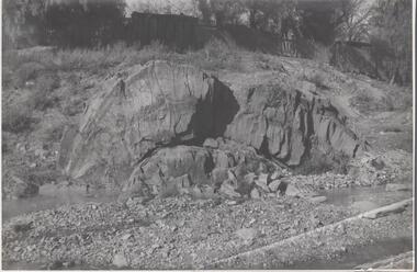
Photograph - Napoleon Anticline, 1935
In structural geology, an anticline is a type of fold that is an arch-like shape and has its oldest beds at its core, whereas a syncline is the inverse of an anticline. A typical anticline is convex up in which the hinge or crest is the location where the curvature is greatest, and the limbs are the sides of the fold that dip away from the hinge.Significant to mining history of Bendigo.Black and white photograph: rock formation, anticline with an archlike shape in centre of image. Written in pencil on back of photograph : 'Napoleon anticline Golden Square'.napoleon gold mine, anticline -
 The Beechworth Burke Museum
Geological specimen - Azurite, Unknown
Azurite is a secondary copper mineral made by the weathering of copper sulphide ore deposits. Azurite is formed from copper, carbon, oxygen and hydrogen. There are over 45 forms of azurite that are more well-known, however over 100 forms have been found. Azurite is also commonly found together with Malachite, and Azurite is often psuedomorphed to Malachite. This specimen was found at the Great Cobar Copper Mine in New South Wales, which was founded in 1870. At the time it was one of the largest mining operations in the world. It was the largest copper mine in Australia and housed the southern hemisphere’s tallest chimney stack. The international price of copper collapsed at the end of World War 1 which led to the closure of the Great Cobar Mine on March 16th 1919. A year later on March 10th 1920 an underground fire in the CSA (Cornish, Scottish, Australian) mine started and burned for 16 years. The closure of the mine and the fire left thousands jobless and many people left the area. These were factors in Cobar facing a long stretch of poverty, until a boom in the 1960s led to the reopening of the mine. The mine still operates today, obtained by Metals Acquisition Limited in June 2023. Azurite is considered an uncommon mineral. Named for its deep blue colour, azurite was historically used for pigment making and as a gemstone, despite its softness. This specimen was donated to the Burke Museum between 1868-1880 as part of a larger collection of geological and mineral specimens. Many of the specimens in this collection were obtained as part of the Geological Survey of Victoria, which started in 1852. The Survey aimed to map the scientific makeup of the earth.A solid copper mineral with shades of darker blues almost covering it.burke museum, beechworth, indigo shire, beechworth museum, geological, geological specimen, mineralogy, cobar mines, great cobar copper mine, cobar mining, new south wales, azurite, azurite specimen -
 Bendigo Historical Society Inc.
Map - HUSTLER'S REEF & HUSTLER'S REEF NO 1 MINES - PLAN OF THE HUSTLER'S REEF & HUSTLER'S REEF NO 1 MINES
Plan of the Hustler's Reef & Hustler's Reef No 1 Mines on the Hustler's Line of Reefs, Bendigo Bulletin No 33, Plate No XIV. No 8 connecting No 10 (Hustler's Reef), No 11 connecting No 13 (Hustler's Reef), No 13 (Hustler's Reef No 1) connecting No 15 (Hustler's Reef) and No 10 Hustler's Reef No 1 rise to Comet Mine. Map shows different levels in relation to the two shafts, the lines of the Hustler's Line of Reefs and the Lightning Hill Line of Reefs, the approximate Boundary of Lease and the Comet Co., the adjoining lease. Table on the left shows the levels and their depths of the two mines. Signed by H A Whitelaw, Underground Survey Office, Bendigo, September 1913. Geological Survey of Victoria emblem. mining, parish map, hustler's reef & hustler's reef no 1 mines, hustler's line of reefs lightning hill line of reefs, comet co., h a whitelaw, underground survey office bendigo, geological survey of victoria -
 Bendigo Historical Society Inc.
Map - HUSTLER'S REEF & HUSTLER'S REEF NO 1 MINES - LONGITUDINAL SECTION OF THE HUSTLER'S REEF & HUSTLER'S
Longitudinal Section of the Hustler's Reef & Hustler's Reef No 1 Mines on the Hustler's Line of Reef. Bulletin No 33, Plate No XX. Note - Plates 4, 8, 13, 20, 26 & 31 form a Longitudinal Section from Fortuna Hustler's to Hustler's Consols Mine. Geological Survey of Victoria emblem. Signed by H A Whitelaw, Underground Survey Office Bendigo, September 1913. Shows the two shafts with their levels and depths. Also shows geographical features and yields of gold and amalgam per ton. .mining, parish map, hustler's reef & hustler's reef no 1 mines, geographical survey of victoria, underground survey office bendigo, h a whitelaw -
 Bendigo Historical Society Inc.
Map - HUSTLER'S REEF & HUSTLER'S REEF NO 1 MINES - PLAN OF THE HUSTLER'S REEF & HUSTLER'S REEF NO 1 MINES
Plan of the Hustler's Reef & Hustler's Reef No 1 Mines on the Hustler's Line of Reefs Bulletin No 33, Plate No XVII. Two drawings with different levels on each for clarity. Shows depth and some geographical features. Geological Survey of Victoria emblem. Signed by H A Whitelaw Underground Survey Office Bendigo, September 1913. mining, parish map, hustler's reef & hustler's reef no 1 mines, hustler's line of reefs, geological survey of victoria, underground survey office bendigo, h a whitelaw -
 Bendigo Historical Society Inc.
Map - HUSTLER'S REEF & HUSTLER'S REEF NO 1 MINES - PLAN OF THE HUSTLER'S REEF & HUSTLER'S REEF NO 1 MINES
Plan of the Hustler's Reef & Hustler's Reef No 1 Mines on the Hustler's Line of Reefs Bulletin No 33, Plate No XV. Plan shows the two mines with depth of levels, geological features and levels in relation to the shaft. Geological Survey of Victoria emblem and signed by H A Whitelaw, Underground Survey Office Bendigo, September 1913. Note - The Lease Boundaries shown on this plan are only in their approximate relative positions to Nos 13, Intermediate and 14 Levels of the Hustler's Reef No 1 workings, and Nos 15, 16 and 17 Levels of the Hustler's Reef workings.mining, parish map, hustler's reef & hustler's reef no 1 mines, geological survey of victoria, underground survey office bendigo, h a whitelaw, hustler's line of reefs -
 Bendigo Historical Society Inc.
Map - HUSTLER'S REEF NO 1 MINE - EAST & WEST CROSS-CUTS OF THE HUSTLER'S REEF NO 1 MINE
Map showing the East & West Crosscuts, North & South of Shaft of the Hustler's Reef No 1 Mine on the Hustler's Line of Reefs Bulletin No 33, Plate No XXII. Drawing shows where the different levels are, the stone encountered and smaller drawings of other sections near the shaft. Also shows some geographical features. Signed by H A Whitelaw, Underground Survey Office Bendigo, September 1913. Geological Survey of Victoria emblem.mining, parish map, hustler's reef no 1 mine, geological survey of victoria, h a whitelaw, underground survey office bendigo, hustler's line of reefs -
 Bendigo Historical Society Inc.
Map - COMET MINE - LONGITUDINAL SECTION COMET MINE
Longitudinal section of the Comet Mine on the Hustler's Line of Reef Bulletin No 33, Plate No XXVI signed by H. S. Whitelaw, Underground Survey Office Bendigo, September 1913. Map shows datum lines, depths of levels, approximate boundaries and references to other plans. Note - Plates 4, 8, 13, 20, 26 and 31 form a Longitudinal Section from Fortuna Hustler's to Hustler's Consols Mine. Geological Survey of Victoriamining, parish map, hustler's line of reef, longitudinal section of comet mine bulletin no 33 plate no xxvi, h s whitelaw -
 Bendigo Historical Society Inc.
Map - COMET MINE - TRANSVERSE SECTION COMET MINE
Transverse section of the Comet Mine on the Hustler's Line of Reef Bulletin No 33, Plate No XXV signed by H. A. Whitdon, Underground Survey Office Bendigo September,1913. Map shows depth of the different levels, the type of stone and shaft about 2020 deep. A number of smaller drawings on the side. Reference explaining the different types of stone, etc. Geological Survey of Victoriamining, hustler's line of reefs, transverse section of comet mine bulletin no 33 plate no xxv, lightning hill line of reef -
 Bendigo Historical Society Inc.
Map - COMET MINE - PLAN OF COMET MINE
Plan of the Comet Mine on the Hustler's Line of Reefs Bulletin No 33, Plate No XXIII. Map shows depths, Lightning Hill Anticline, Hustler's Anticline and approximate Lease Boundary. Signed by H. S. Whitelaw, Underground Survey Office Bendigo, September 1913. United Hustler's & Redan Co and Hustler's Reef Co also named on map. Geological Survey of Victoriamining, hustler's line of reefs, comet line plan belletin no 33 plate no xxiii, lightning hill anticline, hustler's anticline, united hustler's & redan co, hustler's reef co, h s whitelaw -
 Bendigo Historical Society Inc.
Map - COMET MINE - PLAN OF COMET MINE
Plan of the Comet Mine on the Hustler's Line of Reefs Bulletin No 33, Plate No XXIV signed by H S Whitelaw, Underground Survey Office Bendigo, September 1913. Upper and Lower Levels and approximate boundaries shown. Depths shown.Geological Survey of Victoriamining, parish map, hustler's line of reefs, comet mine plan bulletin no 33 plate no xxiv -
 Bendigo Historical Society Inc.
Map - HUSTLERS LINE OF REEFS - LONGITUDINAL SECTION THROUGH THE SADDLE REEFS
Drawing with Longitudinal Section through the Saddle Reefs along portion of Hustler's Line of Reefs, Bendigo. Map shows the depth of the mines, reef numbers and Datum 700 ft above sea level. North and South is also noted on the map. Map signed by H. S, Whitelaw, Underground Survey Office, Bendigo, September 1913. Bulletin No 33, Plate No XXXIV. Bendigo Creek, Ironbark Creek and Long Gully are also noted. Mines are: Fortuna Hustlers, Hustler's Royal Reserve No 2 Main Shaft, Hustler's Royal Reserve No 2 Park Shaft, Royal Hustler's, Imperial Hustler's, Extended Hustler's Freehold, Great Extended Hustler's Tribute (Pups), Old Shaft, Great Extended Hustler's Reef No 2, Great Extended Hustler's Main Shaft, Old Shaft, Hustler's Reef, Hustler's Reef No 1, Comet, K. K., United Hustler's & Redan, Old Shaft and Hustler's Consols. Has Geological Survey of Victoria Crest and underneath is: H. Herman, Director, W. Dickson, Secretary for Mines, The Hon. J Drysdale Brown M L C. Minister of Mines.Geological Survey of Victoria Crestmining, hustler's reef maps, hustlers line of reefs, bendigo creek, royal hustler's, imperial hustler's, extended hustler's freehold, great extended hustler's tribute (pups), great extended hustler's reef no 2, great extended hustler's main shaft, hustler's reef, hustler's reef no 1, united hustler's & redan, old shaft and hustler's consols.h s whitelaw, underground survey office bendigo september 1913 -
 The Beechworth Burke Museum
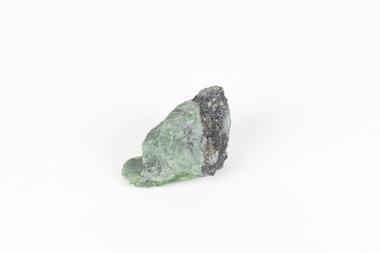
Geological specimen - Green Feldspar (orthoclase)
Feldspar, derived from the German word feldspat, is a group of minerals which is the most common mineral group found on Earth, making up more than half of the planet's crust. The major rock-forming minerals in the Feldspar group include albite, anorthite, orthoclase and microcline. (Mindat, Feldspar Group). Orthoclase is part of the Feldspar Group subgroup, Alkaline Feldspar, which are known to be poor in calcium, and mostly rich in potassium. It is further also considered to be a K Feldspar, a subgroup of Alkaline Feldspar that are Potassium-dominant with variable crystal symmetry and Al-Si ordering state. Orthoclase are most commonly Colorless to white, Greenish white, Grayish yellow, or Pale pink and transparent to translucent with slightly pearly cleavage. The mineral rates at a 6 on the Mohs Hardness Scale. (cannot be scratched with a knife, but scratches glass with difficulty). The stronger green colour of this particular specimen is distinctive to the Broken Hill region (where it was found), and due to a small amount of lead. (BB) Its qualities find it misidentified at times as as microcline variety amazonite. Broken Hill is one of the world’s richest lead-zinc-silver deposits. The huge, 300-million-tonne orebody was discovered in 1883 and the superb mineral specimens attract collectors from around the world. (Australian Museum, Minerals from Australia: Australian mining regions)While feldspar is not by any means rare, this particular specimen has qualities distinctive to the Broken Hill mining district, with these properties leading at times to the mineral's misidentification. This creates potential for further study and identification of these mineral deposits through methods such as microscopic twinning, or using the position of certain d values in XRD patterns to calculate the degree of disorder of a K-feldspar, as discussed on the Mindat website (Mindat.com, Orthoclase:About Orthoclase). This specimen is part of a larger collection of geological and mineral specimens collected from around Australia (and some parts of the world) and donated to the Burke Museum between 1868-1880. A large percentage of these specimens were collected in Victoria as part of the Geological Survey of Victoria that begun in 1852 (in response to the Gold Rush) to study and map the geology of Victoria. Collecting geological specimens was an important part of mapping and understanding the scientific makeup of the earth. Many of these specimens were sent to research and collecting organisations across Australia, including the Burke Museum, to educate and encourage further study.A solid small aluminosilicate mineral composition which is primarily pale green and blue-grey in colour with traces of beige and white throughout. Note: green plumbian orthoclase (aka green feldspar) is an indicator mineral for the Broken Hill style lead-zinc deposits.N/Abroken hill mine, geological specimen, minerology -
 The Beechworth Burke Museum
Geological specimen - Tourmaline (schorl), Unknown
Tourmaline is a group of minerals belonging to the complex borosilicate mineral class. These minerals are known for their striking and varied colours, making them prized gemstones. Tourmaline crystals can come in various shades, including pink, green, blue, brown, black, and colourless. They are often transparent or translucent. Tourmaline's chemical composition is complex, but it typically includes elements such as aluminium, iron, magnesium, sodium, lithium, and potassium. The specific arrangement of these elements in the crystal lattice gives rise to the different colours and properties of tourmaline specimens. Tourmaline specimens from Beechworth, Victoria, Australia, are a notable part of the region's mineral heritage. These tourmalines are of interest to mineral collectors and enthusiasts. While the tourmaline found in Beechworth is not as well-known as some other tourmaline varieties, it has unique characteristics and a historical context associated with the gold mining areas in Beechworth.The significance of tourmaline in Beechworth, Victoria, Australia, lies in its unique geological and historical context, contributing to both scientific and cultural aspects. The tourmaline mined in Beechworth is a rare and unique variety of tourmaline that is primarily found in the historic gold mining areas surrounding Beechworth. Its occurrence is closely linked to the geological processes that shaped the region during the Gold Rush era. The discovery of tourmaline in Beechworth adds to the rich mineral heritage of the area, which was historically known for gold mining. The specimens serve as a tangible connection to the region's mining history and contribute to preserving its geological legacy. The presence of tourmaline in Beechworth showcases the mineralogical diversity of the area. Tourmaline is known for its wide range of colours and unique properties, making it a valuable subject of study for mineralogists and geologists. Tourmaline specimens from Beechworth have educational significance, providing opportunities for research and study. They offer insights into the geological processes and mineral formation in the region, contributing to a better understanding of Earth's geological history.A hand-sized solid mineral specimen in shades of brown, green, light grey and dark greyTOURMALINE (schorl) / (Silicate of boron and aluminum) burke museum, beechworth, indigo shire, geological, geological specimen, mineralogy, tourmaline -
 The Beechworth Burke Museum
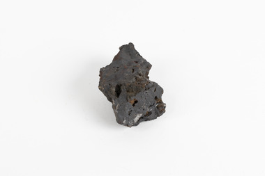
Geological specimen - Hematite (iron oxide)
Hematite is an iron ore significant for its high iron content (70%) and as being one of the two main iron oxide minerals, the other being magnetite. Hematite has a rating of 5-6 on the Moh's hardness scale and is often found as an accessory mineral in many igneous rocks. (an accessory mineral being "any mineral in an igneous rock not essential to the naming of the rock" - Britannica) Hematite has historically been the mainstay of South Australia’s iron ore production. (Magnetite: South Australia’s potential) Making up the eastern section of the Gawler Rangers, the Middleback Range is a mountain range on the eastern side of Eyre Peninsula in South Australia that has been a source of iron ore (its main commodity in minerals) for over a century. (see https://www.mindat.org/loc-22576.html). "Large reserves of high-grade iron ore were identified in 1890 in the Middleback Range, west of Whyalla. From 1915 these ores were shipped to Newcastle and later to Port Kembla, both in New South Wales. Local production of pig iron began when the first blast furnace was opened at Whyalla in 1941, and construction of an integrated iron and steel plant began there in 1958." (Britannica, South Australia: Resources and power). This area is home to 24 mines/mineral deposits (according to mindat.org, thought the Sarig Map provided by SA gov on their Energy and Mining website indicates significantly more mining leases).This mineral specimen was collected from the Middleback Ranges before the area was identified as holding large reserves of iron ore and being commercially mined and is representative of South Australia's significant and ongoing history of iron ore mining, and its contribution to Australia's steel manufacturing industry of the early 20th century (this specimen being collected in the prelude to these events).A small ferric oxide mineral composition a mid-blue-grey in colour with specks of rust-brown throughout.HEMATITE / (iron oxide) / Locality: Middleback Ranges, S. Aust.middleback ranges, iron ore mining, mining, south australia -
 Bendigo Historical Society Inc.
Map - HUSTLER'S REEF NO 1 MINE - TRANSVERSE SECTION OF THE HUSTLER'S REEF NO 1 MINE
Map of a transverse Section of the Hustler's Reef No 1 Mine on the hustler's Line of Reefs Bulletin No 33, Plate No XXI. Map shows poppet legs at 801.07 feet above Sea Level and drawing of shaft with the different levels. Also shown are geological features and stone encountered. Geological Survey of Victoria emblem H Herman, Director, W Dickson, Secretary of Mines and The Hon. J. Drysdale Brown MLC Minister of Mines. Signed by H S Whitelaw, Underground Survey Office Bendigo, September 1913. This item has not been scanned or photographed.mining, parish map, hustler's reef no 1 mine, hustler's line of reefs, geological survey of victoria, underground survey office bendigo, h s whitelaw, h herman, w dickson, the hon j drysdale brown