Showing 467 items
matching mining site.
-
 Buninyong & District Historical Society
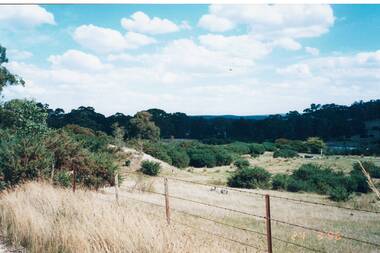
Photograph - Original Photograph, Site of Mine holes and mullock heap, Green Hill Diggings, Sandy's Hill Rd., Durham Lead, 20/03/1996
historic, miningColour photo, Site of Mine holes and mullock heap, Green Hill Diggings, Sandy's Hill Rd., Durham Lead, mining, green hills, sandy's hill rd., durham lead -
 Puffing Billy Railway
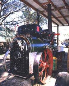
Portable Compound Steam Engine, Marshall & Son's - Builders Number 48317, circa 1908 / 1909
Portable Compound Engine - Marshall & Son's. Builders Number 48317 Built by Marshall Sons & Co., Ltd., Gainsborough, England (Builder’s Number 48317 of approximately 1908/1909), to the order of Robison Brothers, Engineers, South Melbourne. It was used for operating a pump to supply irrigation water at Robinvale in Northern Victoria. Robison Bros & Co. P/L was founded by James McFarlane Robison and his brothers in 1854, initially as plumbers and coppersmiths, the firm expanded into general engineering, boiler-making and brass, iron and steel founders and became one of Melbourne's most important engineering firms. They constructed railway bridges, gold mining equipment, railway locomotives, pumping stations, brewing vessels, abattoir machinery, amongst much else and including the first turnstiles at the Melbourne Cricket Ground. A portable engine is either a steam engine or an internal combustion engine, that remains in one place while operating (providing power to machinery), and can be easily moved from one work site to another. Mounted on wheels or sometimes skids, it is required to be towed between work sites.Historic - Industrial Portable Compound Engine - steam engine - Marshall & Son's. Marshall & Son's Portable Compound Engine - Builders Number 48317 made of steel Marshall & Son's. Builders Number 48317puffing billy, state rivers and water supply commission of victoria, portable compound engine - marshall & son's., portable compound engine, marshall sons & co., ltd., robison bros & co. p/l -
 Puffing Billy Railway
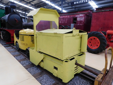
Greenbat Battery Loco, Greenwood & Batley ltd
Greenbat Battery Loco Built by Greenwood & Batley Ltd Builders No. 420363/2 This Greenbat Battery Loco has been loaned to the Museum by the Walhalla Goldfields Railway, who had acquired it in 2013 along with a large quantity of narrow gauge trollies and light rail from Orica’s now closed munitions factory in Melbourne’s western suburbs. The trolley on display was one of two in use from the 1970s. Orica - Deer Park Munitions factory Orica Deer Park in Melbourne’s west has been used since circa 1875 for various forms of manufacturing and storage of chemicals. Although the site is bounded by Ballarat Road, Station Street, Tilburn Road and the Western Ring Road, the current entry point for industrial operations is situated at Gate 6 off Tilburn Road. Operations include: • a specialty chemicals facility producing products for mining services operations • quarry services • other chemical manufacture activities. The Deer Park factory complex is of historical significance as the location of the first plant for the manufacture of high explosives in Australia and has been, for its entire history, the most important, if not only, commercial manufacturer of high explosives in Australia. It commenced operation under the importer Jones Scott and Co, and then the Australian Lithofracteur Company (Krebs Patent), a rival to Nobel's dynamite patent. The factory was producing nitro-glycerine based explosives in Australia only a couple of years after Nobel's Ardeer factory began operating in Scotland. The explosives factories complex is of historical significance for the association with the Australian Lithofracteur Company, Australian Explosives and Chemicals, the Nobel company and later ICIANZ, which grew to become one of the largest explosives, chemical and plastics manufacturers in Australia. It was the pioneer of the industry and retained its dominance through monopolistic practices, taking over most of its competitors in the Australasian region. Substantial parts of the pre-Second World War layout of the site remain which, with a number of significant buildings dating back to the 1920s and '30s, indicate past and present processes of manufacturing, the necessary safety measures required and the integrated nature of the explosives and chemical industry. The narrow gauge tramway, which ran through the explosives section, was a rare survivor of nineteenth century materials-handling methods into the 21st Century. Greenwood & Batley were a large engineering manufacturer with a wide range of products, including armaments, electrical engineering, and printing and milling machinery. They also produced a range of battery-electric railway locomotives under the brand name Greenbat. The works was in Armley, Leeds, UK. Greenbat was the trade name for the railway locomotives built by Greenwood & Batley. The company specialised in electric locomotives, particularly battery-powered types for use in mines and other hazardous environments. Historic - Industrial Narrow Gauge Railway - Battery Locomotive - Orica - Deer Park Munitions factory - Deep park, Victoria, Australia Battery Locomotive - made of iron puffing billy, greenbat battery loco, battery locomotive, industrial narrow gauge railway, orica - deer park munitions factory -
 Puffing Billy Railway
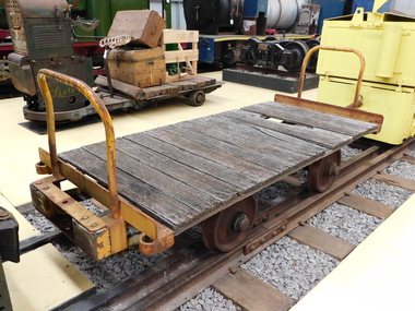
Explosives Wagon, unkown
This 2 foot 6 inch (762mm) gauge wagon was used for carrying explosives and was used with the Greenbat Battery loco. It was donated to the Walhalla Goldfields Railway on long term loan in 2013 along with a large quantity of narrow gauge trollies and light rail from Orica’s now closed munitions factory in Melbourne’s western suburbs. Orica - Deer Park Munitions factory Orica Deer Park in Melbourne’s west has been used since circa 1875 for various forms of manufacturing and storage of chemicals. Although the site is bounded by Ballarat Road, Station Street, Tilburn Road and the Western Ring Road, the current entry point for industrial operations is situated at Gate 6 of Tilburn Road. Operations include: • a specialty chemicals facility producing products for mining services operations • quarry services • other chemical manufacture activities. The Deer Park factory complex The factory complex is of historical significance for the major role it played in Australia's manufacturing and mining industries through the development of progressively more efficient and safer explosives. It also contributed to wartime production in ammunition, initiators and the development of synthetic ammonia production and construction of the Defence Explosives Annexe No 5 (later the Albion Explosives Factory) during World War Two. The factory complex is also of technical significance for the unusual and specialised design of many of the buildings and structures, both in the layout of the works and the individual design of buildings. Blast protection and safety measures such as mounds around the buildings, 'cleanways' and buffer zones between production areas were employed extensively. A characteristic of many production buildings was the elimination of cavities where explosive compounds could lodge. The combination of concrete barriers and light-weight construction was designed to direct explosion debris away from operators or other buildings. The narrow gauge tramway, which ran through the explosives section, is a rare survivor of nineteenth century materials-handling methods. Historic - Industrial Narrow Gauge Railway - Wagon for carrying Explosives at the Orica - Deer Park Munitions factory, Deer park, Victoria, Australia Wagon for carrying explosives made from Timber and steelwagon for carrying explosives, puffing billy, industrial narrow gauge railway, orica - deer park munitions factory, explosives wagon -
 El Dorado Museum Association Inc.
Photograph (item) - Digital Image
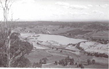
Cocks Pioneer Ponds, c. 1930s. Cocks Pioneer Electric Gold & Tin Mine Company was formed in 1899. The company's first power station, located at the eastern end of the valley began operating with its 340 Kilowatt steam-powered generator. By 1909, from 2,500,000 cubic yards worked, reported recovery was 17,284 ounces of gold and 224 tons of tin ore. By 1909, Cocks Pioneer’s power plant had become inadequate and uneconomical. The barge was floated downstream about a mile, but lost time caused the operations to cease. Following testing, a new mine was established by diverting Reid's Creek at a cost of £25,000. Settling dams were built, one of which held 1,935,900 cubic feet. Sold earth banks, built against a wall of stringy bark saplings constructed and laced with vertical props, were built. In 1914, the company was reformed as Cock’s Pioneer Gold and Tin Mines NL, another power station was constructed at the western end of the township, near the junction of Clear and Reid's Creeks. From 6,800,000 cubic yards of material processed, the returns were 64 397 ounces of gold and 855 ton of tin. Cocks Pioneer mine then moved the barge downs stream and continued sluicing. In 1929 Cocks Pioneer Electric Gold and Tin Mining Company ceased operations due to a drop in values. Cock’s Pioneer Gold and Tin Mines NL carried on large-scale hydraulic sluicing operations until 1941. mining, gold, tin, gold mining, tin mining, cocks pioneer, el dorado, eldorado -
 El Dorado Museum Association Inc.
Photograph (item) - Digital Image
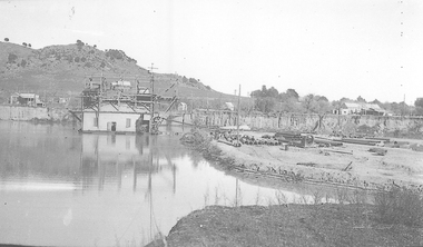
Cocks Pioneer Barge. Cocks Pioneer Electric Gold & Tin Mine Company was formed in 1899. The company's first power station, located at the eastern end of the valley began operating with its 340 Kilowatt steam-powered generator. By 1909, from 2,500,000 cubic yards worked, reported recovery was 17,284 ounces of gold and 224 tons of tin ore. By 1909, Cocks Pioneer’s power plant had become inadequate and uneconomical. The barge was floated downstream about a mile, but lost time caused the operations to cease. Following testing, a new mine was established by diverting Reid's Creek at a cost of £25,000. Settling dams were built, one of which held 1,935,900 cubic feet. Sold earth banks, built against a wall of stringy bark saplings constructed and laced with vertical props, were built. In 1914, the company was reformed as Cock’s Pioneer Gold and Tin Mines NL, another power station was constructed at the western end of the township, near the junction of Clear and Reid's Creeks. From 6,800,000 cubic yards of material processed, the returns were 64,397 ounces of gold and 855 ton of tin. Cocks Pioneer mine then moved the barge downs stream and continued sluicing. In 1929 Cocks Pioneer Electric Gold and Tin Mining Company ceased operations due to a drop in values. Cock’s Pioneer Gold and Tin Mines NL carried on large-scale hydraulic sluicing operations until 1941. mining, gold, tin, barge, sluicing, gold mining, tin mining, cocks pioneer, el dorado, eldorado -
 El Dorado Museum Association Inc.
Photograph - Digital Image
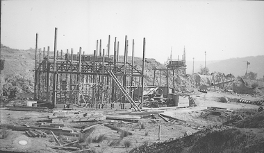
Construction of New Barge, Cocks Pioneer. Cocks Pioneer Electric Gold & Tin Mine Company was formed in 1899. The company's first power station, located at the eastern end of the valley began operating with its 340 Kilowatt steam-powered generator. By 1909, from 2,500,000 cubic yards worked, reported recovery was 17,284 ounces of gold and 224 tons of tin ore. By 1909, Cocks Pioneer’s power plant had become inadequate and uneconomical. The barge was floated downstream about a mile, but lost time caused the operations to cease. Following testing, a new mine was established by diverting Reid's Creek at a cost of £25 000. Settling dams were built, one of which held 1,935,900 cubic feet. Sold earth banks, built against a wall of stringy bark saplings constructed and laced with vertical props, were built. In 1914, the company was reformed as Cock’s Pioneer Gold and Tin Mines NL, another power station was constructed at the western end of the township, near the junction of Clear and Reid's Creeks. From 6,800,000 cubic yards of material processed, the returns were 64,397 ounces of gold and 855 ton of tin. Cocks Pioneer mine then moved the barge downs stream and continued sluicing. In 1929 Cocks Pioneer Electric Gold and Tin Mining Company ceased operations due to a drop in values. Cock’s Pioneer Gold and Tin Mines NL carried on large-scale hydraulic sluicing operations until 1941. mines, mining, gold, tin, gold mining, tin mining, sluicing, barge, construction, cocks pioneer, el dorado, eldorado -
 Tatura Irrigation & Wartime Camps Museum
Book, The Pennyweight Kids, 1988
Written to try to discover why more than 200 children died at Forest Creek, Victoria. Stories of their families.Yellow cover, sketch of scales 1852-1857. Gold mining scene and grieving mother. On back cover sketch of excavation of old burial site. London 1852. Gentleman's Magazine.forest creek victoria, deaths at forest creek victoria -
Tatura Irrigation & Wartime Camps Museum
Folder, Rushworth/Waranga, 2003
... -waranga mining sites goldfields tatura mining whroo documents ...Report on mines, including Balaclava. Extracts from Waranga News. Early happening, settlement life.Black cover with metal clips. Labels on spinerushworth-waranga, mining sites, goldfields, tatura, mining, whroo, documents, reports -
 City of Ballarat
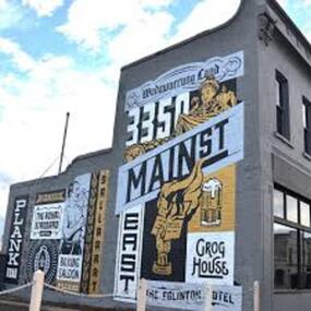
Artwork, other - Public Artwork, Travis Price, Main Road Mural by Travis Price, May 2018
Whilst my main focus for the artwork design was on the Hotels on Main Road, I felt there was an opportunity to tell a broader story of Main Rd and combine/include some interesting pieces of information from many stages of the history of Main Road. Considering that at one point in time there would have been at more than six hotels in this very short section of street….there’s no doubt Main Rd was an epicentre of communication and festivities for the Goldfields of Ballarat. “No matter what luck he had, every miner needed supplies, food and something to entertain him when he was not searching for gold.” Described as being an overcrowded jumble of muddy streets loosely arranged around mining camps...and loud, muddy, colourful and sometimes illicit. I wanted the artwork composition to consist of overlapping images and text to reflect this sense of hustle and bustle. Main Road Mural tells the broader story of the history of Main Road in Ballarat. In 2018, the City of Ballarat commissioned local Ballarat artist Travis Price to create an artwork to align with the Main Road Revitalisation Project and deliver a key component of the storytelling (heritage interpretation) project that spans the length of the shopping precinct. The artwork is featured on a prominent site in the shopping precinct of main road and tells the story of Main Road through depicting key timeline events. Main Road, as its name suggests, was one of the main entries to the mining areas of East Ballarat. It had several names: Main Street before 1858, Plank Road between 1858 and 1868 and Main Road from 1868 onwards. The centre of mining life, it was crowded, prosperous, raucous and dirty. Painted mural on shop wall in Main Road, BallaratBallaarat, Gold Fever, The Royal Standard Hotel, Flood, Boxing Saloon, Plank Road, Kulin Nation, 3350, Election, East, Grog House, The Scandinavian Hotel. Images; Chinese lantern, Pick & Shovel, Miners Licence burning.main road history, ballarat hotels, gold fever, wadawurrung, kulin nation -
 Clunes Museum
Photograph, Jul-01
MODEL MADE BY CARL NORDSTROM ON THE PORT PHILLIP MINE SITE IN 1858. NOW ON DISPLAY AT THE SCIENCE MUSEUM IN MELBOURNE *No longer on display, now archived. ON LOAN TO THE CLUNES COMMUNITY DURING THE 150TH GOLD CELEBRATIONS IN JULY, 2001, AND DISPLAYED IN THE ALL PURPOSE ROOM AT CLUNES PRIMARY SCHOOL.4 COLOURED PHOTOGRAPHS OF THE PORT PHILLIP MINE MODELlocal history, photography, photographs, mining -
Clunes Museum
Sign - DISPLAY PANEL, 2000
COPIES OF DISPLAY PANELS DONATED TO THE PEOPLE OF CLUNES BY THE HUGH WILLIAMSON FOUNDATION.INTERPRETIVE DISPLAY PANEL DEPICTING HISTORY OF SCHOOL DAYS IN CLUNES. WOODEN DISPLAY PANEL AND LAMINATED COPY.SCHOOL DAYS CHILDREN OF EARLY GOLDFIELD TOWNS WERE TAUGHT IN TENT SCHOOLS.THESE SCHOOLS WERE EASILY MOVED TO THE SITE OF THE LATEST GOLDRUSH. WITH GREATER COMMUNITY STABILITY PERMANENT SCHOOLS WERE ESTABLISHED. CLUNES STATE SCHOOL NO. 1552 WAS OPENED IN JULY 1875 ON LAND DONATED BY RIVETT H. BLAND, MANAGER OF THE PORT PHILIP GOLD MINING CO. SHORTLY BEFORE WORLD WAR ONE, THIS SCHOOL BECAME VICTORIA,S THIRD HIGHER ELEMENTARY SCHOOL. TODAY IT IS STILL USED TO EDUCATE THE CHILDREN OF CLUNES STATE SCHOOL NO. 136 WAS BUILT IN 1881 ON THE SITE OF AN EARLIER TEMPORARY SCHOOL THAT WAS BUILT IN 1857. THE DESIGN WAS FIRST USED AT HORSHAM. AND INCLUDES AN EARLY EXAMPLE OF A LARGE SCHOOL VERANDAH. IN 1892 THIS SCHOOL AMALGAMATED WITH STATE SCHOOL NO. 1552 AND WAS USED AS THE INFANT SCHOOL. IT CLOSED ITS DOORS IN 1922 AND WAS LATER USED AS A MILL FOR THE CLUNES KNITTING AND MAUFACTURING CO. LTD. IT NOW HOUSES THE CLUNES BOTTLE MUSEUM THE CLUNES CATHOLIC SCHOOL OPENED IN 1875 AND CLOSED IN 1926 THE LATEST EDUCATIONAL ASSET AT CLUNES IS A CAMPUS OF WESLEY COLLEGE. BLENDINGHISTORIC BUILDINGS AND MODERN ARCHITECTURE THE CAMPUS IS SITUATED IN SERVICE STREETlocal history, civic momentoes, presentations, williamson, hugh foundation -
 Clunes Museum
Photograph
BLACK AND WHITE PHOTGRAPH OF MINERS' COTTAGES NEAR A MINE SITElocal history, photography, photographs, mining -
 Clunes Museum
Photograph
BLACK AND WHITE PHOTOGRAPH OF MINERS' COTTAGES NEAR A MINE SITElocal history, photography, photographs, mining -
 Clunes Museum
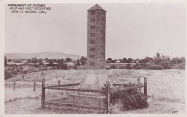
Photograph - PHOTOGRAPH MONUMENT
MONUMENT BUILT AND ERECTED ON SITE OF FIRST GOLD DISCOVERY IN VICTORIA 1851. PORT PHILLIP MINE.BLACK AND WHITE POSTCARD OF A BRICK MONUMENT SURROUNDED BY WOOD AND WIRE MESH FENCE WITH CAMP PARADE AND MOUNT BECKWORTH IN BACKGROUND. PLAQUE ON CEMENT BASE OF BRICK PILLAR.MONUMENT AT CLUNES. GOLD WAS FIRST DISCOVERED HERE IN VICTORIA 1851.photography, monuments, memorials& mining -
 Clunes Museum
Photograph - PHOTOGRAPH MONUMENT
GOLD MONUMENT ERECTED ON SITE OF FIRST GOLD DISCOVERY IN VICTORIA 1851BRICK MONUMENT, SURROUNDED BY MESH FENCE WITH WOODEN POSTS. GRASS GROWING AROUND MONUMENT, MULLOCK HEAPS IN BACKGROUND, HOME ON CAMP PARADE.GOLD MONUMENT CLUNESphotographs, mining civic momentoes, gold monument -
Clunes Museum
Document - CERTIFICATE OF TITLE, APRIL, 1906
ORIGINAL TITLE FOR THE CLUNES FREE LIBRARY SITE IN TEMPLETON STREET ISSUED TO RALPH COUNDON, GAS MANUFACTURER; ARTHUR HENRY GORDON, MEDICAL PRACTITIONER; AND JOHN FIELD, MINING REGISTRAR - 25TH APRIL, 1906. TITLE TRANSFERRED TO CROWN C.1975 AS NO TRUSTEES LEFTPhotocopy of a Certificate of Title issued in Victoria under the "Transfer of Land Act 1890" Issued on the 26th of April 1906 to the Trustees of the Clunes Free Lending Library from the Crown. Signed by H Hosken Assistant Registrar. Handwritten in black ink; J L Lazarus 1183842 Cluneslocal history, document, certificates, free library -
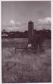
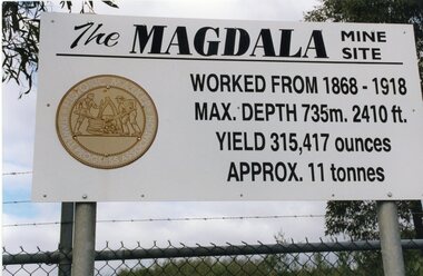 Stawell Historical Society Inc
Photograph, Kevin Patterson, Magdala Mine Site sign and Shaft, Circa 1999
3 Colour Photgraphs: 2 showing information about the mine , the other showing the shaft covered with protecive mesh.Sthe Sign Reads: The Magdala mine site worked from 1868 -1918. Max Depth 735 M. 2410 ft. Yeild 315,417 Ounces Approx 11 Tonnes On Revese: Gold Miners Stawell. Neg 20 mining, magdala -
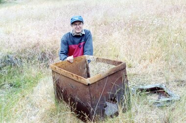 Stawell Historical Society Inc
Photograph, Kempson Mine Site Illawarra
Two Colour Photgraphs: 7078 One Male Greg Cameronwith a blue cap and glasses crouched behind an Ore Truck, photo taken outside. 7078a showing a painted red box, with faded paint, covered in soil with a broken open door that was used as a powder magazine.mining -
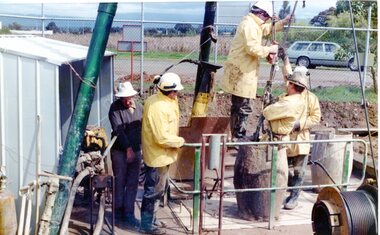 Stawell Historical Society Inc
Photograph, Magdala Shaft, 1986
7082a: - Induction fan discharge from the Stawell Gold MIne, this gunck would include the diesel fumes of trucks and mining machines. The steam Plume drifts over the nearby trees blackening and killing the. It also drifts over the reservior adding a touch of spice to the town's drinking water. site closed in 2001. Another fan is located near to Darlington Lane and McLennan Street.2 Photographs: 7082:Showing workmen drilling a shaft with a car in the background 7082a: Showing Steam? coming from the shaft.On Reverse: 7082 Mick Walsh 52 Patrick Street Phone 053 ******mining -
Stawell Historical Society Inc
Archive - Book, Registration Of Residence Sites 3/1/1871 - 17/8/1882, 1871
Residence Area Miners Right Mining used by Stawell ShireVery Large Brown Leather Ledger with marbling on inside cover. Red Label on Spine Registration Booklocal government, miners right -
Stawell Historical Society Inc
Archive - Book, Stawell Shire, Registration Of Residence Sites 20-8-1900 - 22-9-1904, 1900
Residence Area Miners Right Mining used by Stawell ShireVery Large Burgandy Leather Ledger with marbling on inside cover. Red Spine and Corners IndexedRegister of Residence Area Book 6Plocal government, miners right -
Stawell Historical Society Inc
Archive - Book, Stawell Shire, Registration Of Residence Sites 28-7-1931 - 20-6-1934, 1931
Residence Area Miners Right used by Stawell ShireLarge Brown Covered Leather Ledger with Label on front coverStawell Ararat Mining District Registration Book 12P local government, miners right -
 Stawell Historical Society Inc
Photograph, St. Patrick’s Catholic Church
St. Patrick’s Catholic Church and surrounding buildings 1880's. The church was opened in 1873. The construction is of Black Ranges faced with Grampians Freestone. The bell tower is 70 feet high, and the walls are 30 inches thick. The church was opened on 30th March 1873 by the Bishop of Melbourne, the Right Reverend Dr. Goold. The Historical Society have a programme for this opening - tickets for front seats were 10/- each. The sanctuary was added during 1927 as was a white marble altar which was the gift of a parishioner. Much earlier - In 1865 - a wooden Catholic Church was built on this street near the Court House site. The wooden building became too small for the congregation and this church was commenced before the end of 1869. Sepia photograph of St Patrick's Catholic Church and surrounding buildings. The photo also shows mining operations in Stawell with the Grampians in the background c 1880's. Two enlargements of the Catholic Church are taken from the sepia photograph and marked as 105a.C. Herbert. Photo. Copyright Registered Stawell. on the back is written "Stawell from Big Hill c 1880" stawell, panorama, mining -
Stawell Historical Society Inc
Map, Western Mining Corp / Stawell Joint Venture, Stawell & District with Mine Working Areas shown in red, 1987
Covers from Magdala East site to Germania in North and Hand in Hand at West Legend of Mine workings numbered. 1980's mining, gold, map -
Stawell Historical Society Inc
Map, Stawell Joint Venture, Mine Site Detail Plan, September 1989
1989mining, gold, map -
Stawell Historical Society Inc
Map, Stawell Gold Mine, Milling Area Site Arrangement 2002, 12/6/2002
Plus Bench Mark Levels Stawell Gold Mines Victoria Scale 1 : 20000mining, gold -
 National Wool Museum
Textile - Community Textile Tapestry, Lisa Kendal et al, WARM, 2016
WARM was a community textile art project that saw over 250 knitters come together to create a beautiful collage tapestry. Made entirely from wool, the artwork contains more than 1000 individual hand knitted sections. The project takes aim at global warming, it highlights both the causes and solutions for us to create a sustainable and safe climate for future generations. Lisa Kendal, the co-creator of the project, said “One of the problems in the world is that we have forgotten how to warm ourselves with wool. We have become too dependent on fossil fuels (for heating)”. This is the key idea surrounding the project. WARM began as two large scale images created by Lars Stenberg. The first image is a landscape scarred by coal mining. The second image is the same landscape only many decades later. Regeneration and regrowth have taken over the landscape and hidden the past coal mine completely. In its place is a beautiful landscape including trees, native flowers, a lake, lots of greenery and wind turbines. From March to the end of August in 2016, knitters worked hard to create the over one thousand pieces that came together to form the final tapestry. The pieces were all designed by Fibre Artist Georgie Nicolson of Tikki Knitting Designs, who converted the second image of the healed landscape into patterns for the 250 plus knitters to follow. These patterns included unusual designs such as gum leaves, trees, native flowers and even the wind turbines. During several days of installation, the knitted pieces were stitched together by Lars Stenberg over a picture of the first image of the operational coal mine. They worked to create the second image of the renewed landscape; like an enormous collage. The WARM project was donated to the National Wool Museum in 2021. It was a much-loved hanging within the Ballarat Hospital for many years before coming to the museum. More information about the project can be found on the following website. http://www.seam.org.au/warm The tapestry is made from 1000+ hand knitted sections stitched together to make an image. In the foreground of this image is a large gum tree that stretches from the bottom left to the top right corner. The trunk of this tree follows the left edge of the tapestry, with foliage from the gum tree spanning its top border. The bottom third of the tapestry is predominantly green grass with yellow, pink and red flowers providing sporadic colour. The middle third encompasses a lake, with orange colours surrounding the banks of the water as opposed to the green grasses of the bottom third. To the right of the lake are wind turbines. The top third of the tapestry is blue sky with white clouds. It also contains the previously described gum tree leaves. Each piece of the tapestry is 100% wool and was hand knitted and stitched together. The Tapestry is accompanied by an oil painting on canvas. It is a painting that matches the tapestry and served as a template for the final tapestry. Finally, the tapestry is accompanied by another pointing on wood board. This final panting is of a coal mine. This is the setting before regeneration and regrowth have reclaimed this site, which is the theme captured in the final tapestry. In the foreground of the coal mine painting is the same gum tree described in the tapestry; however, it is grey and sickle with only 4 leaves visible at the top border, compared to the numerous leaves in the tapestry. Also in the foreground is a broken barb wire fence adding to the unwelcoming nature of the site. The colour scheme of this image is of dark greys and browns. A coal fired power plant can be seen in the final third of the image with four chimneys emitting plumes of smoke into the sky. In front of this power plant is the spiral shape of a coal mine, burrowing deep into the earth’s crust. Inside of the coal mine 3 yellow trucks are seen mining and transporting coal to the top of the mine.warm, community textile tapestry, knitting, community artwork, global warming -
Whitehorse Historical Society Inc.
Article, Old gold mine site is found
The exact site of the old goldmine in the Lake Road - Halley Street area of Blackburn was located and identified by local history investigators.The exact site of the old goldmine in the Lake Road - Halley Street area of Blackburn was located and identified by local history investigators. Ray Champion said it was on a property he owned, his father Isaac Champion had filled in the mine in 1904. The mine had successfully operated up until about 1880.The exact site of the old goldmine in the Lake Road - Halley Street area of Blackburn was located and identified by local history investigators. mines and mining, champion, isaac, ray, halley street, blackburn, lake road, dickens street, goldmining -
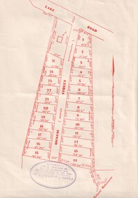 Whitehorse Historical Society Inc.
Document, Dickens Street, Blackburn
Auction of housing development in Dickens Street, Blackburn, comprising 25 sites, leading off Lake Road. Agent Frank Fisher & Co.dickens street, blackburn, frank fisher co., lake road