Showing 1182 items matching "municipality"
-
 Warrnambool and District Historical Society Inc.
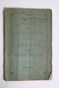
Document - Town of Warrnambool By-laws and Regulations 1898, M Hassett "The Reporter" Printing Works, 1898
Warrnambool was created as a municipality on 7th December 1855, declared a Borough on 1st October 1863, proclaimed a Town on 2nd February 1883, and a City on 8th April 1955. This booklet is of significance as it shows the governance of the Town of Warrnambool in 1898, fifteen years after Warrnambool was proclaimed as a town.A 54 page bound paper booklet with a green cover. The inside front page has a handwritten Government Gazette reference to the proclamation of Warrnambool as a town.Town of Warrnambool By-Laws and Regulations Warrnambool M Hassett "The Reporter" Printing Works Timor Street 1898 Higgins & Parrington handwritten in inkwarrnambool, town of warrnambool, municipal bylaws and regulations -
 Greensborough Historical Society
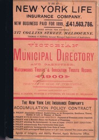
Book - Directory, Arnall and Jackson, Victorian Municipal Directory and Gazetteer 1900, 1900
A compilation of facts and figures of the local government areas in Victoria in 1900.659 p., text.non-fictionA compilation of facts and figures of the local government areas in Victoria in 1900.municipal directories, gazetteers, local government, victoria history -
 City of Moorabbin Historical Society (Operating the Box Cottage Museum)
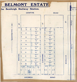
Flyer, 1922
At the end of World War One, there was a renewed interest in residential land and a number of estates opened up in the Municipality of Moorabbin. Belmont eState, Bentleigh was auction on 9 December 1922.Example of the progress of the Municipality of MoorabbinAdvertising flyer for auction of real estate sales - plan of building blocks for saleBelmont Estate, Bentleigh Railway Stationmavho street, loranne street, brewer road, bentleigh, auction, bentleigh railway station, real estate -
 Port Melbourne Historical & Preservation Society
Document - William Robert COOPER Retirement Tribute, Weekly Times, 26 August 1911
John William COOPER landed at Liardet's Beach in late 1852. A builder by trade, he settled in Sandridge and was active in creating Sandridge as an independent municipality. His was Elizabeth HARRIS. Two stapled A4 sheets with photocopy of tribute on retirement of William Robert COOPERjohn willian cooper, local government - borough of sandridge, elizabeth harris -
 St Kilda Historical Society
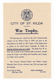
Ephemera - Flyer, War Trophy, 1923
Promotion of a ceremony to install a long-range gun captured by the AIF in 1918 and given to the Municipality of St Kilda as a war trophy at Alfred Square. The ceremony was on 23 June 1923.White paper, discoloured with age, printed in bluealfred square, st kilda war trophy (gun) -
 Eltham District Historical Society Inc
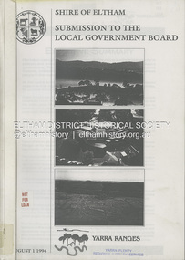
Book, Shire of Eltham, Submission to the Local Government Board: Yarra Ranges, 1 August 1994
A restructure proposal by the Shire of Eltham, named the municipality of Yarra Ranges, reflects a strategic focus. It has natural boundaries and a strong sense of place built on communities of interest. Prepared in consultation with the community and neigbouring municipalities of Diamond Valley and Heidelberg. Contents include: Principles for change, rationale for the proposal, mergers and other restructure proposals. Appendices include: community consultation, Metropolitan Green Wedge Strategy, Constituent Council Benchmark, external refernce benchmark - Moreland, communities of interest, conservation and landcare groups, social profile, key financial management strategies and more.54 pages, 11 Appendicesnon-fictionA restructure proposal by the Shire of Eltham, named the municipality of Yarra Ranges, reflects a strategic focus. It has natural boundaries and a strong sense of place built on communities of interest. Prepared in consultation with the community and neigbouring municipalities of Diamond Valley and Heidelberg. Contents include: Principles for change, rationale for the proposal, mergers and other restructure proposals. Appendices include: community consultation, Metropolitan Green Wedge Strategy, Constituent Council Benchmark, external refernce benchmark - Moreland, communities of interest, conservation and landcare groups, social profile, key financial management strategies and more.local government, municipal restructuring, council amalgamation -
![1981 Warrnambool and District Community Information Directory front cover [.6]](/media/collectors/4f729f7797f83e030860184f/items/664fef1cdd0f9ab6b51abf51/item-media/66c27aa3202c41c4ca03b234/item-fit-380x285.jpg) Warrnambool and District Historical Society Inc.
Warrnambool and District Historical Society Inc.Booklet - Booklet Collection: City of Warrnambool Directory of Services, Collett and Bain
This is a collection of nine directories published by the City of Warrnambool dating from 1952 to 1992. They contain descriptions of the municipality and lists and details of services, social and community facilities for the period covered.These directories give snapshots of the City of Warrnambool for the years covered and will be useful for research.[.1] 16 pages printed with black and white photographs. The cover is cream card with writing in blue printing and the city of Warrnambool crest in the top left corner. [.2] 16 pages printed with black and white photographs. The cover is yellow card with writing in blue printing and the city of Warrnambool crest in the top left corner. [.3] 8 pages printed with pale yellow feathered design edges on either side of the text. The cover is cream with writing in Blue print and the pale yellow feathered pattern. A coloured City of Warrnambool seal is in the centre top third of the front cover. [.4] A single sheet of buff coloured light weight card folded in half to make a booklet. Black printing with a black Warrnambool crest in the top centre. [.5] 36 page booklet. The cover is of white shiny card with printed purple text. [.6] 96 page booklet. The cover has black printed text and red stylised cartoon like drawings representing different aspects of the community. [.7] 32 page booklet. The cover is of cream card printed with a 5mm wide green line across the front and back. Black ink drawings of Warrnambool landmarks by P Bryant feature on the cover and the Warrnambool City seal is in the bottom right hand corner. [.8] 20 page booklet of white paper with black text printing. There is a photo of the Tourist information centre on the rear cover. The Warrnambool city crest on the front cover which has a black geometrical edging design. [.9] 24 page booklet of white paper with black text printing. The front cover has the Warrnambool city crest in the top left hand corner and a photograph of the Lake Pertobe playground in the bottom two thirds. The back cover has a photo of the Warrnambool Saleyards. [.1] City of Warrnambool Victoria, Australia [.2] City of Warrnambool Victoria, Australia [.3] City of Warrnambool [.4] City of Warrnambool Organisations taking part in the Community Life of the City of Warrnambool 1952 [.5] Warrnambool Directory of Social Services [.6] Community Information Directory Warrnambool and District 1981 [.7] Community Information Guide 1991/1992 City of Warrnambool [.8] Citizens' Information Handbook for 1976-1977 [.9] Citizens' Information Handbook for 1977-1978 warrnambool, warrnambool city directory, warrnambool community organisations -
 Bendigo Historical Society Inc.
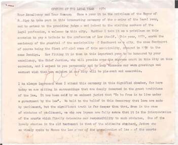
Document - NORMAN OLIVER COLLECTION: SPEECH NOTES. OPENING OF THE LEGAL YEAR 1971
The Norman Oliver collection. Norman Oliver was three times Mayor of Bendigo - 1950-51, 1964-65, 1970-71. Three typed pages, titled Opening of the Legal Year 1971. A scrawl in red ink over the front page. Mentions that 1971 marks the centenary of the gazettal of the municipality of Sandhurst as a city. Chief Justice Henry Winneke is to reside over the supreme court of the city for this occasion.bendigo, council, speech notes, norman joseph oliver , councillor norman oliver. legal year 1971. -
 South Gippsland Shire Council
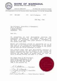
Letter
Typed letter from the Shire of Warragul to Shire of Woorayl. In recognition of Municipality achieving 100 years of local government. Sealed with Common Seal and signed by the Mayor, a Councillor and the Chief Executive Officer. Note: Item approved for deaccession August 2023. SGSC will now follow deaccession procedures as outlined in the Arts and Civic Memorabilia Collection Policy - https://www.southgippsland.vic.gov.au/downloads/file/2763/arts_and_artefacts_collection_policy_c69. -
 City of Moorabbin Historical Society (Operating the Box Cottage Museum)
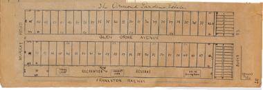
Plan - Ormond Garden Estate, Ormond, 1920
At the end of World War One, there was a renewed interest in residential land and a number of estates opened up in the Municipality of Moorabbin. Ormond Garden Estate was auctioned on Saturday 10 April, 1920.Example of the progress of the Municipality of MoorabbinHand drawn plan of subdivisionOrmond Garden Estatenorth road, glen orme avenue, murray road, ormond, auction, real estate -
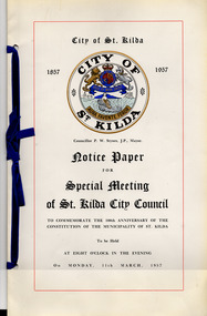 St Kilda Historical Society
Administrative record - Council notice papers, Notice Paper for Special Meeting of St Kilda City Council, 1957
The publication comprises both the notice paper for and minutes of a special meeting of St Kilda City Council to commemorate the 100th Anniversary of the constitution of the municipality of St Kilda, on 11 March 1957.Booklet of glossy white card (discoloured with age) bound with blue ribbon. Printed in black with coloured highlights.city of st kilda centenary, city of st kilda -
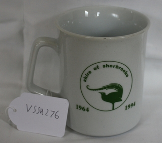 Southern Sherbrooke Historical Society Inc.
Souvenir Mug, 1994
A mug made for the staff/community party to mark the end of the Shire of Sherbrooke municipality after amalgamation with Lilydale, Healesvill and Upper Yarra councils to form the Shire of Yarra Ranges in 1995.Souvenir mug to celebrate the Shire of Sherbrooke after amalgamation.On one side says "Sherbrooke Farewell" on other side "Shire of Sherbrooke 1964-1994" with the Shire of Sherbrooke Lyrebird logo within a circle. Underneath "CS Hose Glassware Pty Ltd Glass and Ceramic Decorators Est 1945 ph 03-7811966. Blank made in China designed and decorated in Australia."sherbrooke, souvenirs -
 Kew Historical Society Inc
Photograph - Yarra in Flood from Willsmere, North Kew, 1923
Flooding of the Yarra Valley, including that section of the Yarra bordering Kew and Kew East in the north and west of the municipality, was a regular occurrence. Extreme flood events of the Yarra River are recorded to have occurred in 1891, 1901, 1916, 1923 and 1934. The Municipality of Kew's response to these floods was to enact planning decisions restricting residential development in flood prone areas following the floods of 1916, 1921 and 1934. While floods continued after the development of the Upper Yarra Reservoir (construction 1948-57), the regularity and extent of these inundations diminished. Original, large sepia photograph showing men, women and children who have gathered on a grassy verge, probably farm land, to look out across the flooded Yarra Valley at Willsmere, North Kew. In the medium distance are three houses that are largely submerged by the flood waters as well as a number of Eucalypts. Judging by the clothes of the spectators, the date might be 1901 or 1916, but probably the latter due to the hats worn by a number of the women. Inscribed reverse: "Gift of Kerrie Woollard (KCC) (P)C.1923yarra river valley, kew east (vic.), floods, willsmere -
 Kew Historical Society Inc
Photograph - Flood at Fairfield Park, 1934
Flooding of the Yarra Valley, including that section of the Yarra bordering Kew and Kew East in the north and west of the municipality, was a regular occurrence. Extreme flood events of the Yarra River are recorded to have occurred in 1891, 1901, 1916, 1923 and 1934. The Municipality of Kew's response to these floods was to enact planning decisions restricting residential development in flood prone areas following the floods of 1916, 1921 and 1934. While floods continued after the development of the Upper Yarra Reservoir (construction 1948-57), the regularity and extent of these inundations diminished.Black and white print positive. Yarra River at Fairfield in 1934. Major flood resulting in submerged buildings in middle ground and onlookers on far bankReverse: "Flood of Yarra at Fairfield Park 1934"fairfield park, yarra valley, river yarra, floods -- 1934 -
 Kew Historical Society Inc
Photograph - Yarra in Flood, 1934
Flooding of the Yarra Valley, including that section of the Yarra bordering Kew and Kew East in the north and west of the municipality, was a regular occurrence. Extreme flood events of the Yarra River are recorded to have occurred in 1891, 1901, 1916, 1923 and 1934. The Municipality of Kew's response to these floods was to enact planning decisions restricting residential development in flood prone areas following the floods of 1916, 1921 and 1934. While floods continued after the development of the Upper Yarra Reservoir (construction 1948-57), the regularity and extent of these inundations diminished.Black and white print positive. 1934 floods of the Yarra Valley. Location Fairfield looking towards wooded hillside. Houses floating in river.Reverse: "From Fairfield Park (11936?) back towards hill (Wurundjeri Spur?)"floods -- 1934, yarra valley, yarra river, fairfield park -
 Kew Historical Society Inc
Photograph - River Yarra in Flood from Kilby Road
Flooding of the Yarra Valley, including that section of the Yarra bordering Kew and Kew East in the north and west of the municipality, was a regular occurrence. Extreme flood events of the Yarra River are recorded to have occurred in 1891, 1901, 1916, 1923 and 1934. The Municipality of Kew's response to these floods was to enact planning decisions restricting residential development in flood prone areas following the floods of 1916, 1921 and 1934. While floods continued after the development of the Upper Yarra Reservoir (construction 1948-57), the regularity and extent of these inundations diminished.Print copy of an original photo of the River Yarra in Flood, taken from Kilby Road.VIEW ACROSS YARRA IN FLOOD / FROM KILBY RD KEWkilby road, floods -- kew (vic.), kilby farm -
Kew Historical Society Inc
Collection, Floods in North Kew (Series), 1929–1934
Flooding of the Yarra Valley, including that section of the Yarra bordering Kew and Kew East in the north and west of the municipality, was a regular occurrence. Extreme flood events of the Yarra River are recorded to have occurred in 1891, 1901, 1916, 1923 and 1934. The Municipality of Kew's response to these floods was to enact planning decisions restricting residential development in flood prone areas following the floods of 1916, 1921 and 1934. While floods continued after the development of the Upper Yarra Reservoir (construction 1948-57), the regularity and extent of these inundations diminished. Natural disasters had an impact on the development and settlement of Melbourne and its suburbs. Flooding in the Melbourne region was a regular event in the nineteenth and for most of the twentieth centuries. Changes in the impact of natural disasters could occur due to a number of factors. This collection of small snapshots, mostly taken from Kellett Grove in North Kew, provide provenanced evidence of flooding in the area before the development of the unnatural flood barrier that is the Eastern Freeway.Collection of 16 monochrome photographs, annotated on verso by different hands, of the flooding of the River Yarra in North Kew in the third and fourth decades of the twentieth century [1920s & 1930s]. Individual photos include the dates of different floods. Many of the photos were taken from the rear of 8 Kellett Grove; a house still extant in 2023yarra river -- north kew, floods -- yarra valley, floods -- north kew, floods -- 1929, floods -- 1934, natural disasters -- kew -
 Wodonga & District Historical Society Inc
Photograph - Framed photograph of John Woodland and Family, Wodonga, c. 1870s
John Woodland was the first President, Secretary and Engineer for the Shire of Wodonga, after it separated from the Yackandandah Shire in 1876, when the Victorian Government agreed to a ratepayers' petitions to form a new municipality.The framed photograph of John Woodland has local significance as he was the first President, Secretary and Engineer for the Shire of Wodonga when it was established in 1876. The photograph has historical significance as it is an illustration of three generations of a prominent family in Wodonga in the late 19th century in the stylised setting typical of that time. It also shows the kind of clothes and hair styles men, women and children from well-to-do familes wore.Sepia-toned photograph of John Woodland and his family in a brown wooden frame with a gold bevelled edge and grey matt board. Hand written inscription on the cardboard on the back of the frame." Mr John Woodland / & Family / first President / Secretary / Engineer } for Wodonga Shire" on the top of the cardboard back and above the following inscription: "Son Mr Charles Woodland & Grandson. / Daughters Mrs. R. F. Murphy, Secretary for Council for 35 years after her father's death / Mrs. Susan Nunan"john woodland, wodonga shire, woodland family, wodonga, john woodland photographs -
 Ringwood and District Historical Society
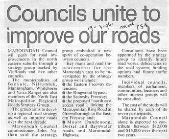
Newspaper, Scrapbook Clipping, Library Collection, Ringwood, Victoria
Newspaper Clipping from The Mail, 19-3-96, P 5. Councils unite to improve our roads.Maroondah Councilwill push for road improvements in the north eastern suburbs through a strategy group backed by Vicroads and five other councils. The municipalities of Banyule, Nillumbik, Manningham, Whitehorse and Yarra Ranges are also members of North East Metropolitan Regional Roads Strategy Group. -
 Ballarat Tramway Museum
Administrative record - Memorandum, State Electricity Commission of Victoria (SECV), "Tramways", 25/01/1962 12:00:00 AM
Yields information about the method of advising the City of Ballarat and the Borough of the planned closure of the tram system, parliamentary processes and a fare increase., Yields information about the method of advising the City of Ballarat and the Borough of the planned closure of the tram system, parliamentary processes and a fare increase.Memorandum on foolscap paper sent by the Melbourne office, Engineer and Manager SEC to the Manager Ballarat, dated 25/1/1962, advising both Managers of the Bendigo and Ballarat district of the proposal to close the tramways, that Fare increases had been approved, Notices to the Municipalities would be issued soon on 1/2/1962 by the Departmental Superintendent and an outline of the Parliamentary process to be followed and giving time for alternative services to be arranged.Date stamped 30/1/62 and has file number in the top right hand corner in ink and pencil notes in left hand margin.trams, tramways, closure, staff, sec, ballarat, city of ballarat, borough of sebastopol, fares -
Kew Historical Society Inc
Archive (Sub-series) - Subject File, Kew Historical Society, Garbage Disposal (Kew), 1958
Various partiesReference, Research, InformationSecondary Values (KHS Imposed Order)Subject file containing primary resources/publications and newspaper articles/clippings. The oldest item in the file is a ‘Report on the Sub-Committee of the Conference of Municipalities on the Best Means of Disposing of Street and House Refuse, Street Sweepings and other Garbage of the Metropolitan Area (Brunswick, Slobom & Co., Printers, 1 Union Street, 1901). The other publication dates from 1993 and is City of Kew: Your guide to total waste management.sanitation - kew (vic), garbage - kew (vic.)sanitation - kew (vic), garbage - kew (vic.) -
 Williamstown Botanic Gardens- Hobsons Bay City Council
Oral History_Williamstown Botanic Gardens_Michael Wilkins, 06/10/2014
The interview is one of a series recorded in 2013-2014 to document memories and experiences of the Williamstown Botanic GardensA primary source of information on memories of the Gardens and witness to changes in the Gardens over those years. CD and transcript of interview with Michael Wilkins. Michael first worked in the Gardens for the Municipality of Williamstown in 1987. He was there for eleven years. A few years after the amalgamation of Williamstown and Altona into the City of Hobsons Bay City Council he transferred from the Gardens to other sites within the City. He returned to the Gardens in 2006. Michael recalls people with whom he worked and horticultural practices over those years. michael wilkins, barry heath, bob anderson, 1987, shelley wood, ian mcleod, john wilson, mary malhallchek, glasshouse, maarten hulzebosch, ransome mower, buffalo lawn, parker reserve, trench digging, 2006, bird cage, palms, williamstown botanic gardens, hobsons bay city council -
 Bendigo Historical Society Inc.
Document - GOVERNOR'S RECEPTION 1861
Victorian Governor, Sir Henry Barkly visited Bendigo in Oct. 1861 as part of his regional tour that included, Castlemaine, Chewton, Back Creek and Inglewood.Buff coloured document. Written on top 'The Governor's Reception by the Loyal Citizens of the Town of Sandhurst on Thursday October 10th 1861. The program for the day is detailed, with instructions as to the order that participants should muster before the greeting of the Governor at the City Boundary at Kangaroo Flat. 'His Excellency will be welcomed to Sandhurst at the Town Boundary at Two o'clock p.m by Robert Strickland Esq. J.P. Chairman of the Municipality on behalf of the People of Sandhurst'bendigo, council, governor's reception 1861 -
 Glenelg Shire Council Cultural Collection
Mixed media - Framed Art Work, Wallace, Carmel et al, Lagoon Page 3, 2004
© Anna Lanyon , Carmel Wallace 2004. Apart from any fair dealing for the purposes of private study, research, criticism or review permitted under the Copyright Act, no text, image or part thereof may be reproduced, stored in a retrieval system, or transmitted in any form, without prior written permission from the authors.This suite of etchings explores the natural and social history of Fawthrop Lagoon, an ancient intertidal lagoon that lies at the heart of Portland on the far south-west coast of Victoria, Australia. The work records and interprets essential moments in the life of the lagoon, the plants, birds, insects, water-creatures and humans who have lived and continue to live around its shores. White card backing with white torn looking inner frame. Centre is print of an extract taken from a survey record of the Fawthrop Lagoon Portland listing the name of the reserve, Allotment number, section number, Township, and Municipality. Markings and dates have been written in. Around the outside of the centre image is hand written wording in fine black ink and a map of the town of Portland also in black ink.4/30 Lagoon, Page 3 Carmel Wallacefawthrop lagoon, portland, victoria, australia, plants, birds, insects, water, creatures, humans -
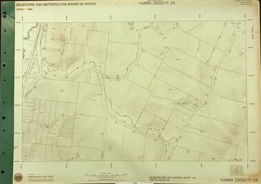 Greensborough Historical Society
Map, Melbourne and Metropolitan Board of Works. Survey Division, MMBW, Yarra 2500 / 17.25. Hurstbridge, 1978_01
Melbourne and Metropolitan Board of Works. Yarra 2500 [base map] 17-26. Hurstbridge. Municipalities of Diamond Valley 257 and Eltham 238. Prominent streets include: Silvan Road and Hurstbridge Road. MMBW Map in 1:2500 [scale] series. Cream parchment with green tape reinforcing on edges and punched holes on left edge.mmbw, melbourne and metropolitan board of works, shire of diamond valley, hurstbridge - maps -
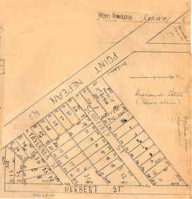 City of Moorabbin Historical Society (Operating the Box Cottage Museum)
Plan - Highlands Estate, Moorabbin
The train line from the city to Frankston was electrified in 1922 which intensified the sale in the municipality of Moorabbin, particularly land which was in the vicinity of the railway stations. This estate was auctioned on Saturday, October 20, 1923.Example of the progress of the Municipality of MoorabbinAdvertising flyer for auction of real estate sales - plan of building blocks for saleHighlands Estate, Moorabbin plan.point nepean road (nepean highway), schofield street, taverner street, herbert street (now linton street), moorabbin, real estate, auction -
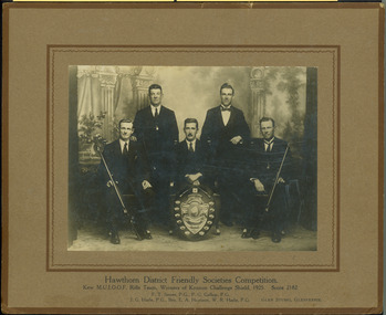 Kew Historical Society Inc
Photograph, Hawthorn District Friendly Societies Competition, 1925
Rifle competitions were popular activities for men in the nineteenth and first half of the twentieth century. The Kew MUIOOF was based in Union Street, Kew and as a friendly society competed in competitions locally and in neighbouring municipalities.Monochrome print positive mounted on card. The photo shows the Kew MUIOOF rifle team which won the Kennon Challenge Shield in 1925. In the studio portrait, taken by Glen Studio (Glenferrie), the five team members are posed, two in front with rifles with the Kennon Challenge Shield positioned at front centre."Hawthorn District Friendly Societies Competition / Kew MUIOOF Rifle Team, Winners of Lennon Challenge Shield, 1925. Score 2182 / FT James PG; PG Gallop PG / JG Harle PG; Bro EA Harrison / WR Harle PG / Glen Studio, Carnegie"muioof, kew muioof, rifle competitions, friendly societies -- kew (vic.) -
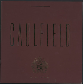 Glen Eira City Council History and Heritage Collection
Booklet, "Caulfield For All Reasons", After 1977
This booklet contains information and pictures about the suburb of Caulfield, including information regarding development, education, recreation, heritage, culture, horse racing, lifestyle in the municipality. It also includes a map of the City of Caulfield. Booklet with maroon colour cover with gold colour printed lettering on the front: "Caulfield For All Reasons", with the City of Caulfield's Caulfield Coat of Arms. The booklet is made up of 10 paper pages with images and text on both sides. -
Ringwood and District Historical Society
Newspaper Cutting, Newspaper articles from 1920 regarding Cr. A. Temple Miles of Ringwood and an 1854 house, 1. Unknown|2. 3-Dec-1920
1. Some of the history of Quambee House with two photos.|2. Personal notice stating that Cr. A. Temple Miles has been elected the first Mayor of the Municipality.|See also 3340 1-2Photocopies of two newspaper articles:; 1. Unique house built in 1854; 2. Personal notice dated 3-Dec-1920 about Cr. A. Temple Miles +Additional Keywords: Miles, A. Temple, Cr. -
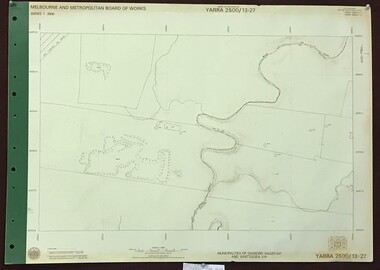 Greensborough Historical Society
Map, Melbourne and Metropolitan Board of Works. Survey Division, MMBW, Yarra 2500 / 13.27. Morang wetlands, 1977_09
Melbourne and Metropolitan Board of Works. Yarra 2500 [base map] 13.27. Morang wetlands. Municipality of Diamond Valley 257 and Whittlesea 239. Features include the Plenty River and SEC Transmission Line easement. MMBW Map in 1:2500 [scale] series. Cream parchment with green tape reinforcing on edges and punched holes on left edge.mmbw, melbourne and metropolitan board of works, shire of diamond valley, morang - maps