Showing 324 items
matching nepean road
-
 City of Kingston
Photograph - Black and white, 17 January 1951
... (top left), Park Road, Cheltenham (top right), Nepean Highway... right), Nepean Highway (left section), Graham Road and Middleton ...Moorabbin, Cheltenham and Highett are suburbs in the City of Kingston with a diverse mix of development and zoning. This 1954 image shows the market gardens, farms and paddocks of the Moorabbin and Cheltenham area. which have gradually been sub-divided into The Highett Gas Works is visible and Cheltenham Park and Victoria Golf Club.The suburbs of Cheltenham and Moorabbin were originally developed with extensive market gardens. Over time the district has been transformed with the farms and paddocks replaced by housing, factories and shopping centres. The Highett Gas Works on the Nepean Highway was a significant feature of the landscape and has now been demolished. and the site has undergone remediation.Aerial photograph of Cheltenham, Moorabbin and Highett within the City of Kingston. The area depicted in this 1951 aerial view includes Wickham Road, Highett (bottom right), Keys Road, Moorabbin (bottom left), Centre Dandenong Road Cheltenham (top left), Park Road, Cheltenham (top right), Nepean Highway (left section), Graham Road and Middleton Street, Highett (bottom right). Cheltenham Park and Victoria Golf Club are visible. Nepean Highway and the Frankston railway line run centrally through the image.White type: 1416-37 538 RUN239 LENS 5312" MELBOURNE METROPOLITAN 12150 17-1-51 ↆ M539 Black pencil: N [arrow]cheltenham, highett, highett gas works, market gardens -
City of Kingston
Photograph - Black and white, 3 March 1954
Cheltenham and Moorabbin are suburbs within the City of Kingston that were originally established as rural market gardening communities The area is bordered by Highett and Mentone. The market gardens, farms and paddocks have gradually been sub-divided into housing and industrial estates. Highett is developed with residential homes but was also the site of major facilities such as the Highett Gas Works. This aerial image covers a diverse section of the City of Kingston, taking in the suburbs of Moorabbin, Cheltenham, Highett and Mentone Residential housing development is prominent along the Frankston Railway line and the area still retains extensive market gardens and paddocks yet to be converted to a large industrial and commercial zone.Aerial photograph of Mentone, Cheltenham and Moorabbin within the City of Kingston. The area depicted in this 1954 aerial view includes Warrigal Road and Centre Dandenong Road intersection (top left); Charman Road, Patty Street, Bourke Street, Collins Street Mentone (top right); Keys Road Moorabbin (bottom left); Bay Road, Cheltenham (bottom right), Friendship Square, Cheltenham Park, Victoria Golf Club and Jack Barker Oval are visible. Nepean Highway and the Frankston railway line run centrally through the image. Highett Gasworks is also evident.White handwriting and type [indecipherable]. White image of clockface White image of compass White type 42956 Black handwriting 3/3/54 Williams [indecipherable] Black pencil: S [arrow] Black ink: 3/3/1954cheltenham, moorabbin, mentone, highett, market gardens -
City of Kingston
Photograph - Black and white, 20 December 1945
This aerial image covers a section of Cheltenham, with a large paddock yet to be converted to an industrial and later a commercial zone.This aerial photograph provides evidence of the changing landscape of Cheltenham and Highett since WWII. Photographed in 1945, the image features a large block of land now the site of site the major transformation of Cheltenham with the development of the Southland shopping centre in the 1960s and expansion in the 1990s.Aerial photograph of the Cheltenham area in the City of Kingston. This 1945 image is concentrated on the area between Bay Road and Garfield Lane with the distinctive bend into Jean Street. A large block of land runs between the Nepean Highway and the rail line. This is now the area occupied by the extension of Southland in the 1990s.cheltenham, southland, aerial photograph, highett -
City of Kingston
Photograph - Black and white, 20 December 1945
This aerial image covers a section of Cheltenham, with a large paddock yet to be converted to an industrial and later a commercial zone.This aerial photograph provides evidence of the changing landscape of Cheltenham and Highett since WWII. Photographed in 1945, the image features a large block of land now the site of site the major transformation of Cheltenham with the development of the Southland shopping centre in the 1960s and expansion in the 1990s.Aerial photograph of the Cheltenham area in the City of Kingston. This 1945 image is concentrated on the area between Bay Road and Garfield Lane with the distinctive bend into Jean Street. A large block of land runs between the Nepean Highway and the rail line. This is now the area occupied by the extension of Southland in the 1990s. It is a negative version of VKHC124.cheltenham, southland, market garden -
 City of Kingston
Photograph - Black and white, c.1945
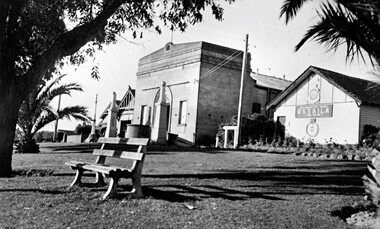
This photograph shows the Protestant Hall on Nepean Highway Cheltenham, which at the time of the photograph was used by the Returned Sailors' Soldiers' and Aimen's Imperial Leage of Australia (RSSAILA). The building facade, World War I memorials, fire station building and road plantation are also in view. The Protestants Hall was built by the Cheltenham Protestant Hall Company Limited in 1886. The hall has been used for a wide variety of purposes; in earlier times it served as the Sunday School for the Methodist Home for Children, and later as a schoolhouse when the Beaumaris School (now Cheltenham State School) No 84 met with overcrowding problems. It was also a popular venue for annual balls and regular dances held by church groups and sporting organisations. The City of Moorabbin purchased the building in the 1920's for use by the Returned Soldiers and Sailors League, in whose hands it remained until the late 1970s when it was taken over by a catering firm. During the 1920s, and right up to the late 1950s, it also served as Cheltenham's picture theatre. The three memorial columns, one from the South African War, one from World War I and one from World War II previously located in front of the hall were relocated when Nepean Highway was widened. The Protestant Hall still stands at 1261 Nepean Highway CheltenhamBlack and white digital image depicting three buildings. The right hand building bears a sign that reads RSSAILA. There are trees and a bench seat in the foreground. There is a World War I memorial pictured. world war i, world war ii, protestant hall, cheltenham, returned sailors' soldiers' and aimen's imperial leage of australia (rssaila), returned and service's league (rsl) -
 City of Kingston
Photograph - Black and white, c. 1965
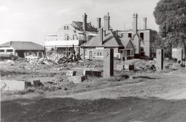
The St John of God Home for Disadvantaged Boys was located on Nepean Highway Chletenham, and was previously known as the Methodist Children's Home. It opened in approximately 1953 and was later demolished to make way for Southland Shopping Centre. The Brothers of St John of God were a Catholic order that first arrived in Australia in 1947, establishing their first school for boys with learning difficulties. They soon acquired 20 acres in Cheltenham in 1953, which became home to 100 boys and young men who could no longer live with their familiesBlack and white image of a demolition site where the St John of God Home for Disadvantaged Boys once stood. Buildings are visible behind the boys' home site, although also slated for demolition.Black printed text on white round sticker on reverse: 231 Handwritten in red ink on reverse: 95%religion, cheltenham, orphanage, boys home -
 City of Kingston
Photograph - Black and white, c. 1940
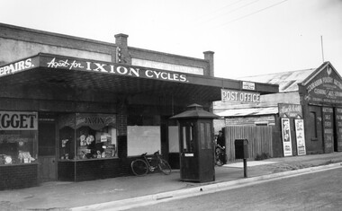
Black and white image featuring Mr Whalebone's bicycle shop, the post office and the Poultry Auction Centre along Nepean Highway, Moorabbin. In front of the shops is a telephone booth. There is a bike leaning against the front window of the post office and between the post office and the poulty auction shop is a picket fence with a gate, and two boys are coming through the gate, one of them wheeling a bike.Black printed ink on a round white sticker on reverse: 160 -
Linton Mechanics Institute and Free Library Collection
Book - Novel, Gibbs, Philip (Philip Armand Hamilton Gibbs), The age of reason, [n.d.] [1928?]
288 p. : section of original dust jacket pasted to front cover, with image of a man engrossed by scientific instruments while a woman dances in the background.fictionfiction, philip gibbs -
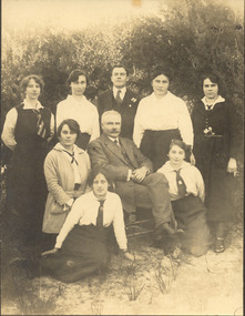
 City of Kingston
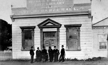
Photograph - Black and white, Percy Fairlam, Mechanics Institute and Temperance Hall, Cheltenham, c.1910
... of the land where Charman Road joined Point Nepean Road ...The Institute movement came to Melbourne in 1839 with the establishment of the Melbourne Mechanics’ Institute later known as the Melbourne Athenaeum. Adopting the principles of self help, social improvement and the recognition of the importance of useful knowledge, it maintained a library, a reading room and an art gallery, while also establishing classes and lectures in a variety of fields. Various dates have been suggested for the founding of the Cheltenham Mechanics’ Institute with the range being somewhere between 1853 and 1856. The first Institute building erected on the tip of the land where Charman Road joined Point Nepean Road was of weatherboard construction. It consisted of a small hall, a reading room and a library. Later it was realized that the building was inadequate for community functions that attracted a large number of participants; consequently additions and modifications were needed. The Shire Council in 1888 voted £10 to the building fund but stipulated that the money would only be paid when the new building was commenced. Major contributors to the fund were the temperance societies who were regular users of the Institute’s facilities. As a result of their contributions the building was named Mechanics’ Institute Free Library and Temperance Hall with this title being proudly painted on its façade in ‘gold letters shaded with blue’.Black and white image of a group of six men dressed in suits and wearing hats, standing at the front entrance of the Mechanics Institute, Free Library and Temperance Hall, Cheltenham -
 Greensborough Historical Society
Poster - Planning Document, City of Heidelberg, Subdivision Plan # G 27, Greensborough and Diamond Creek, 1922 and 1963
Plan of Subdivisions in City of Heidelberg: Side 1: 2 plans, Parish of Keelbundoora: plan 1: Henry Street, Vermont Avenue, Lyell Street, Nell Street, McDowell Street, 1922. Plan 2: Henry Street, Nepean Street, Charles Street, 1922. Side 2: 2 plans Parish of Nillumbik, Portion 13: Plan 1: Diamond Creek Road, Delfin Crescent, Ridge Road, 1963. Plan 2: Kinglake Road, Eltham Road, 1963.An example of hard copy subdivision plans from the Greensborough area. Mainly from the Shire of Diamond Valley era (1964-1994).Plan (2 sided) mounted on heavy card. Contains 2 sheets pasted together.Stamped and handwritten Council permissions, dates and other details.subdivision plans, city of heidelberg -
 Melbourne Tram Museum
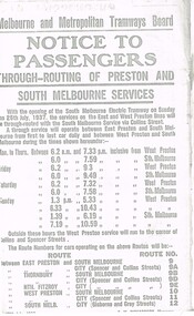
Document - Photocopy, Melbourne & Metropolitan Tramways Board (MMTB), "Notice to Passengers - Through routing of Preston and South Melbourne Services", Originals - 1937
... Cemetery tramway via Hawthorn Road, to Point Nepean Rd, East...Melbourne Tram Museum 8 Wallen Road Hawthorn melbourne ...Set of three photocopied notices onto foolscap, heat sensitive paper, c1937, with details of alterations due to revised or new tram routes. All signed S. M. Richardson as Manager. .1 - "Notice to Passengers - Through routing of Preston and South Melbourne Services" Gives new route numbers. Dated 10th July 1937. .2 - "Notice to Passengers - Extension of Brighton Cemetery tramway via Hawthorn Road, to Point Nepean Rd, East Brighton" - November 1937, part of copy missing on left hand side. Opening date to be 5th December 1937. .3 - "Notice to Passengers - Collingwood cable tramway bus service on Sunday mornings", gives details of bus times and frequency - and commencement times for the cable trams. Dated 3rd November 1937.trams, tramways, preston, south melbourne, east brighton, hawthorn rd, opening, routes, buses, cable trams, collingwood -
 Melbourne Tram Museum
Letter, Australian Electric Traction Association (AETA), "Proposal to build a tramline down Nepean Highway to Southland", May. 1977
Letter with supplementary document - "Proposal to build a tramline down Nepean Highway to Southland", advocating residents support a study into a possible tram line to Southland, May 1977. The Nepean Highway was being widened at the time. Produced by the AETA. Printed by duplicating process on white foolscap paper.trams, tramways, public transport, mmtb, proposals, moorabbin -
 City of Moorabbin Historical Society (Operating the Box Cottage Museum)
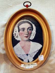
Print - Mary Ann Charman 1820 - 1870
... ground and Chapel in Balcombe Road. Mary died 1870. Stephen... ground and Chapel in Balcombe Road. Mary died 1870. Stephen ...Mary Ann Charman was a pioneer settler in the Cheltenham area of the Parish of Moorabbin c1850 Stephen Charman , who emigrated in 1942 as a Henry Dendy employee aged 21 years, sadly lost his wife and child shortly after arriving in Brighton. When Dendy could not employ him he found other work. In 1850 he met Mary Gettens a widow with 5 children who supported her family by managing her late husband’s Inn in Collins St. Melbourne. Stephen purchased land in Spring Grove, now Cheltenham, in 1852 and the family moved to the wattle and daub hut after their marriage. Mary and Stephen worked very hard to establish a market garden, poultry and pork farm . They specialised in Marigolds which they sold to Martin & Pleasance Pharmacy , Melbourne for medicinal purposes. Mary and Stephen had 7 more children and Mary still managed to find time to sell the pork, poultry and vegetables from a horse drawn cart she drove around St Kilda. 1857 Stephen donated land to the Methodist Church for a School, burial ground and Chapel in Balcombe Road. Mary died 1870. Stephen remarried in 1878 and died aged 85 years 1906. Charman Road runs from Nepean Highway , Cheltenham through Beaumaris to the Beach Road at Mentone. Mr Les Jones was the Great Grandson of Mary Ann CharmanAn oval framed colour copy of a painting of the likeness of Mary Ann Charman, 1820 - 1870 pioneer settler in the Cheltenham area of the Parish of Moorabbinpioneers, early settlers, dendy henry, charman mary ann, jones les, cheltenham, moorabbin, brighton, market gardeners, dairy farmers, charman road -
 Chelsea & District Historical Society Inc
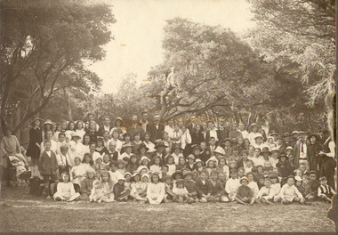
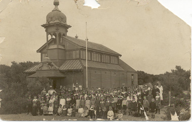
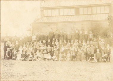
Photograph - Chelsea State School, Students, staff and Family on a picnic, c 1912-14
... , with 65 students, in Hoadley’s Hall, located on Main Road, Chelsea..., with 65 students, in Hoadley’s Hall, located on Main Road, Chelsea ...In January 1912, a small school was established at Chelsea, with 65 students, in Hoadley’s Hall, located on Main Road, Chelsea, near the Nepean Highway. Due to its Oriental appearance, the local people called this hall “The Joss House.” Hoadley's Hall was was originally used at the Melbourne Show Grounds by Hoadley's which was moved to Chelsea. The Hall was also used for church services by different religions before they built their own churches. A new brick school was built on Argyle Avenue and officially opened on 27 January 1915.Sepia photo of children, staff and family from Chelsea State School, at a picnic, amongst the te trees.chelsea, education, chelsea primary school, school, hoadleys hall, joss house, picnic, te trees -
 Chelsea & District Historical Society Inc
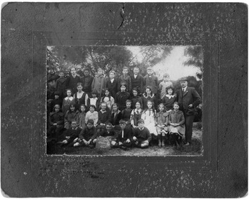
Photograph - Chelsea State School, Grade 6, 1920
... , with 65 students, in Hoadley’s Hall, located on Main Road, Chelsea..., with 65 students, in Hoadley’s Hall, located on Main Road, Chelsea ...In January 1912, a small school was established at Chelsea, with 65 students, in Hoadley’s Hall, located on Main Road, Chelsea, near the Nepean Highway. Due to its Oriental appearance, the local people called this hall “The Joss House.” A new brick school was built on Argyle Avenue and officially opened on 27 January 1915.Black and white photo of Grade 6 children at Chelsea State School, in 1920, with the Headmaster, George Rogerschelsea, education, grade 6, george rogers, school, chelsea state school -
 Chelsea & District Historical Society Inc
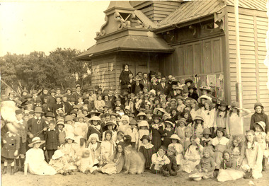
Photograph - Chelsea State School, Children outside Hoadleys Hall "Joss House", 1912
... , with 65 students, in Hoadley’s Hall, located on Main Road, Chelsea..., with 65 students, in Hoadley’s Hall, located on Main Road, Chelsea ...In January 1912, a small school was established at Chelsea, with 65 students, in Hoadley’s Hall, located on Main Road, Chelsea, near the Nepean Highway. Due to its Oriental appearance, the local people called this hall “The Joss House.” Hoadley's Hall was was originally used at the Melbourne Show Grounds by Hoadley's which was moved to Chelsea. The Hall was also used for church services by different religions before they built their own churches. A new brick school was built on Argyle Avenue and officially opened on 27 January 1915.Black and white photo of children at Chelsea State School, in 1912, standing in front of Hoadley's Hall.chelsea, education, chelsea primary school, school, hoadleys hall, joss house -
 Chelsea & District Historical Society Inc
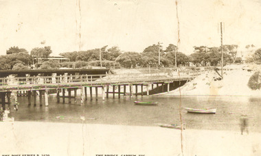
Photograph - Patterson River, Rail and Road Bridge, c 1912
... Sepia photo of the road bridge (Point Nepean / Nepean... Bridge Carrum Bridge Sepia photo of the road bridge (Point Nepean ...The first bridge over the river was built in the early 1880's, prior to this it was a pontoon bridge.Sepia photo of the road bridge (Point Nepean / Nepean Highway) and rail bridge, near the mouth of the Patterson River., Carrum patterson river, road bridge, rail bridge, chelsea, transport, patterson river bridge, carrum bridge -
 Chelsea & District Historical Society Inc
Photograph - Patterson River, Rail and Road Bridge
... Black and white photo of the road bridge (Point Nepean... road bridge rail bridge Chelsea transport Patterson River ...The first bridge over the river was built in the early 1880's, prior to this it was a pontoon bridge.Black and white photo of the road bridge (Point Nepean / Nepean Highway) and rail bridge, near the mouth of the Patterson River. Taken from the mouth of the river.patterson river, road bridge, rail bridge, chelsea, transport, patterson river bridge, carrum bridge -
 Chelsea & District Historical Society Inc
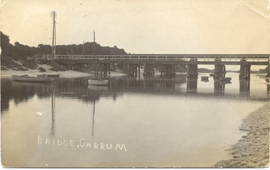
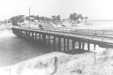
Photograph - Patterson River, Rail and Road Bridge, c 1910
... Black and white photo of the wooden road bridge (Point... road bridge rail bridge Chelsea transport Patterson River ...The first bridge over the river was built in the early 1880's, prior to this it was a pontoon bridge.Black and white photo of the wooden road bridge (Point Nepean / Nepean Highway), over Patterson River, Carrum near the mouth of the river. patterson river, road bridge, rail bridge, chelsea, transport, patterson river bridge, carrum bridge -
 Chelsea & District Historical Society Inc
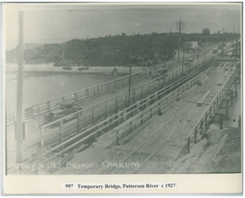
Photograph - Patterson River, Temporary and Old Bridge, c 1927
... Black and white photo of the old wooden road bridge (Point... the construction of a concrete bridge was undertaken. Patterson River road ...The first bridge over the river was built in the early 1880's, prior to this it was a pontoon bridge. In 1927 the construction of a concrete bridge was undertaken.Black and white photo of the old wooden road bridge (Point Nepean / Nepean Highway), and a temporary bridge over Patterson River, Carrum near the mouth of the river. Cars using the old bridge. Rowing boats on shore. Temporary and old bridge, Carrumpatterson river, road bridge, rail bridge, chelsea, transport, patterson river bridge, carrum bridge, temporary bridge, cars -
 Chelsea & District Historical Society Inc
Photograph - Chelsea State School, Children outside Hoadleys Hall "Joss House", 1914
... , with 65 students, in Hoadley’s Hall, located on Main Road, Chelsea..., with 65 students, in Hoadley’s Hall, located on Main Road, Chelsea ...In January 1912, a small school was established at Chelsea, with 65 students, in Hoadley’s Hall, located on Main Road, Chelsea, near the Nepean Highway. Due to its Oriental appearance, the local people called this hall “The Joss House.” Hoadley's Hall was was originally used at the Melbourne Show Grounds by Hoadley's which was moved to Chelsea. The Hall was also used for church services by different religions before they built their own churches. A new brick school was built on Argyle Avenue and officially opened on 27 January 1915.Sepia photo of children and adults at Chelsea State School, in 1914, standing in front of Hoadley's Hall.chelsea, education, chelsea primary school, school, hoadleys hall, joss house, chelsea state school -
 Chelsea & District Historical Society Inc
Photograph - Chelsea State School, Children outside Hoadleys Hall "Joss House", 1912
... , with 65 students, in Hoadley’s Hall, located on Main Road, Chelsea..., with 65 students, in Hoadley’s Hall, located on Main Road, Chelsea ...In January 1912, a small school was established at Chelsea, with 65 students, in Hoadley’s Hall, located on Main Road, Chelsea, near the Nepean Highway. Due to its Oriental appearance, the local people called this hall “The Joss House.” Hoadley's Hall was was originally used at the Melbourne Show Grounds by Hoadley's which was moved to Chelsea. The Hall was also used for church services by different religions before they built their own churches. A new brick school was built on Argyle Avenue and officially opened on 27 January 1915.Sepia photo of children and adults at Chelsea State School, in 1912, standing in front of Hoadley's Hall.chelsea, education, chelsea primary school, school, hoadleys hall, joss house, chelsea state school -
 Chelsea & District Historical Society Inc
Photograph - Chelsea State School, Mr Rogers with staff and family, 1918
... , with 65 students, in Hoadley’s Hall, located on Main Road, Chelsea..., with 65 students, in Hoadley’s Hall, located on Main Road, Chelsea ...In January 1912, a small school was established at Chelsea, with 65 students, in Hoadley’s Hall, located on Main Road, Chelsea, near the Nepean Highway. Due to its Oriental appearance, the local people called this hall “The Joss House.” Hoadley's Hall was was originally used at the Melbourne Show Grounds by Hoadley's which was moved to Chelsea. The Hall was also used for church services by different religions before they built their own churches. Chelsea State School was built on Argyle Avenue and officially opened on 27 January 1915.Sepia photo of Mr Rogers, his staff and family. Mr Rogers was the first Head teacher of Chelsea State School from 1912 to 1917.chelsea, education, chelsea primary school, school, students, school yard, mr rogers, teachers, chelsea state school -
 Chelsea & District Historical Society Inc
Photograph - Chelsea State School, Parents Committee at "Joss House", 1914
... , with 65 students, in Hoadley’s Hall, located on Main Road, Chelsea..., with 65 students, in Hoadley’s Hall, located on Main Road, Chelsea ...In January 1912, a small school was established at Chelsea, with 65 students, in Hoadley’s Hall, located on Main Road, Chelsea, near the Nepean Highway. Due to its Oriental appearance, the local people called this hall “The Joss House.” A new brick school was built on Argyle Avenue and officially opened on 27 January 1915.Black and white photo Parents Committee of Chelsea State School, in front of the school with four scouts with English flags.chelsea, education, chelsea primary school, school, parents committee, scouts, joss house, chelsea state school