Showing 841 items matching "parish plan"
-
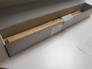
 Rutherglen Historical Society
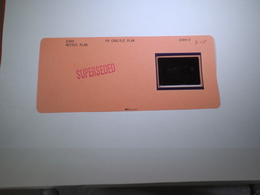
Aperture Card microfilm, Victorian Land Tiltes Office, Parish Plan Carlyle (Superseded)
... Parish Plan Carlyle (Superseded)... with a single microfilm insert Parish Plan Carlyle (Superseded) Aperture ...Town layout of Carlylecard with a single microfilm insertplan, town, boundries, lots, roads -
 Rutherglen Historical Society
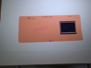
Aperture Card microfilm, Victorian Land Tiltes Office, Parish Plan Carlyle (Superseded)
... Parish Plan Carlyle (Superseded)... with a single microfilm insert Parish Plan Carlyle (Superseded) Aperture ...Town layout of Carlylecard with a single microfilm insertplan, town, boundries, lots, roads -
 Rutherglen Historical Society
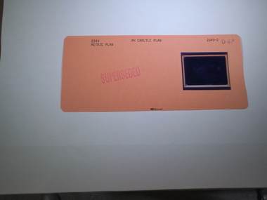
Aperture Card microfilm, Victorian Land Tiltes Office, Parish Plan Carlyle (Superseded)
... Parish Plan Carlyle (Superseded)... with a single microfilm insert Parish Plan Carlyle (Superseded) Aperture ...Town layout of Carlylecard with a single microfilm insertplan, town, boundries, lots, roads -
 Rutherglen Historical Society
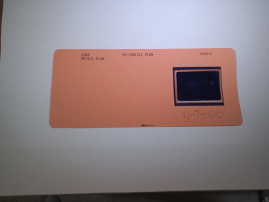
Aperture Card microfilm, Victorian Land Tiltes Office, Parish Plan Carlyle (Superseded), 11/07/2000
... Parish Plan Carlyle (Superseded)... with a single microfilm insert Parish Plan Carlyle (Superseded) Aperture ...Town layout of Carlylecard with a single microfilm insertplan, town, boundries, lots, roads -
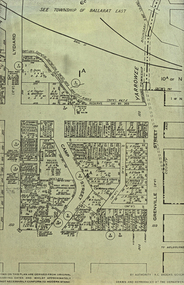 Federation University Historical Collection
Plan, Camp Street Ballarat Parish Plan
... Camp Street Ballarat Parish Plan... of Camp Street Ballarat Camp Street Ballarat Parish Plan Plan Plan ...Camp Street was the site of the original goldfields camp reserve, and it is from here that soldiers and police troopers left to attack the Eureka Stockade on 03 December 1854.PLan of Camp Street Ballaratcamp street, police reserve, old colonists' association, grenville street, lydiard street north, t. cowan, r. surtees, c.m. watson, w.h. foster, j.b. humffray, j.j. goller, h.r. caselli, henry caselli, market reserve, e.v. gribble, old colonists' association of ballarat -
 Bendigo Historical Society Inc.
Map - SANDHURST (PART), Circa 1880's
... parish plan...Map: Parish plan covering the area from Belle Vue Rd... Bendigo parish plan Sandhurst Belle Vue Road Barnard street Maple ...Map: Parish plan covering the area from Belle Vue Rd. to Barnard St. and Maple St to Short St. ( number 230 in Map Cupboard 1)map, bendigo, parish plan, sandhurst, belle vue road, barnard street, maple street , short street -
Bendigo Historical Society Inc.
Map - BENDIGO (SANDHURST) PART, No date visible
... parish plan...Map: Parish plan showing an area North West from... Bendigo parish plan Bendigo Long Gully Map: Parish plan showing ...Map: Parish plan showing an area North West from the McKenzie St. View St. corner to Long Gully ( number 220 in Map Cupboard 1)map, bendigo, parish plan, bendigo, long gully -
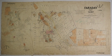 Bendigo Historical Society Inc.
Map - FARADAY, 10/01/1879
... parish plan...Map: Parish of Faraday, County of Talbot. Parish plan...MAP Talbot parish plan Faraday J. H. Morgan J. T. Thomson ...Map: Parish of Faraday, County of Talbot. Parish plan. Draughtsman J T Thomson December 1877. Examined by J H Morgan 8/11/78map, talbot, parish plan, faraday, j. h. morgan, j. t. thomson -
Bendigo Historical Society Inc.
Map - BENDIGO (PART), No date visible
... Bendig parish plan ...Map: Portion of Bendigo parish plan, showing from Murphy St... Bendigo city streets Bendig parish plan Bendigo city streets Map ...Map: Portion of Bendigo parish plan, showing from Murphy St. East to Bob St and between rail line to old saleyards to the old Heathcote line Canvas backed.map, bendigo, city streets, bendig parish plan , bendigo city streets -
Bendigo Historical Society Inc.
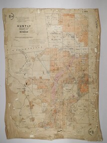
Map - HUNTLY, SHEET 4, 29/03/1876
... parish plan... Draughted Parish plan. Originally in Map Cupboard. Relocated to Map... Bendigo parish plan Huntly Map: Parish of Huntly, Sheet 4, County ...Map: Parish of Huntly, Sheet 4, County of Bendigo. Hand Draughted Parish plan. Originally in Map Cupboard. Relocated to Map Drawer 5 on 22.9.22. Too long for the map cupboard.map, bendigo, parish plan, huntly -
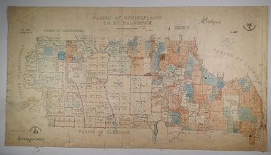 Bendigo Historical Society Inc.
Map - SPRING PLAINS, Examined 31/01/1876
... parish plan...Map: Parish of Springplains, County of Dalhousie. Parish...MAP Dalhousie parish plan Spring Plains A. D. Scott Map ...Map: Parish of Springplains, County of Dalhousie. Parish plan June 1874 A.D. Scott Examined E.D. 4.7.74 Additions made March 1877 Written in blue " See new plan."map, dalhousie, parish plan, spring plains, a. d. scott -
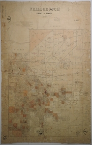
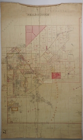 Bendigo Historical Society Inc.
Map - NEILBOROUGH, 21/01/1875
... parish plan... draughted Parish plan. Resurveyed by Mr Assistant-Surveyor G Black...MAP Bendigo parish plan Neilborough G. Black W.A. Taylor ...Map: Parish of Neilborough, County of Bendigo. Hand draughted Parish plan. Resurveyed by Mr Assistant-Surveyor G Black. Drawn by W A Taylor. Map dated 21/1/1875.map, bendigo, parish plan, neilborough, g. black, w.a. taylor -
Bendigo Historical Society Inc.
Map - PARISHES OF CORNELLA AND TOOLLEEN, Circa 1880
... parish plan... hand draughted parish plans applied to vanvas backing... parish plan Cornella Toolleen Map: Parishes of Cornella ...Map: Parishes of Cornella and Toolleen, Compilation of 2 hand draughted parish plans applied to vanvas backing. Originally in Map Cupboard. Relocated to Map Drawer 5 on 5.22.9.22. Too long for the map cupboard.map, parish plan, cornella , toolleen -
 Bendigo Historical Society Inc.
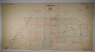
Map - PARISH OF CAMPASPE, November 1880
... parish plan...Map: Parish of Campaspe, County of Rodney. Parish plan...MAP Rodney parish plan Campaspe Map: Parish of Campaspe ...Map: Parish of Campaspe, County of Rodney. Parish plan G.H.H. Smith Draughtsman August 1880 Examined J.A. Morrison 7.10.80 Photo- Lithographed J. Noone. 1.11.80 Written in green " Cancelled 16.2.66."map, rodney, parish plan, campaspe -
 Bendigo Historical Society Inc.
Map - HUNTLY, 16/11/1903
... parish plan...Map: Huntly, County of Bendigo. Parish plan. Drawn...MAP Bendigo parish plan Bartholomew Becket W S Stephen J ...Map: Huntly, County of Bendigo. Parish plan. Drawn by Bartholomew Becket, examined by W S Stephen 15/3/80, examined by J Walshe Sept 1903, additions H Hansford August 1903map, bendigo, parish plan, bartholomew becket, w s stephen, j walshe, h hansford, huntly -
 Bendigo Historical Society Inc.
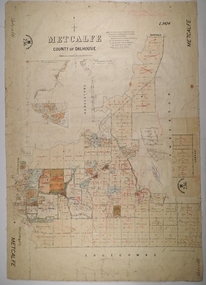
Map - METCALFE, 30/10/1878
... parish plan...Map: Metcalfe, County of Dalhousie. Parish plan (also has...MAP Dalhousie parish plan Metcalfe F. J. Vincent Map ...Map: Metcalfe, County of Dalhousie. Parish plan (also has a smaller addition glued onto the right hand side) F. J. Vincent Draftsman Oct. 1876 Ex (unreadable signature) Oct 1878map, dalhousie, parish plan, metcalfe, f. j. vincent -
Bendigo Historical Society Inc.
Map - CAMPBELL COLLECTION: BENDIGO AND DISTRICT MAPS
... parish plan.... from Field Survey and Parish Plans. Crusoe Reservoir... Bendigo parish plan Map. Marong, Parishes of Marong, Lockwood ...Map. Marong, Parishes of Marong, Lockwood and Mandurang. Scale 20 chains to an inch. Total 5106 acres. Compiled in W.P.B. from Field Survey and Parish Plans. Crusoe Reservoir to the right of map. (number 362 in map cupboard 1)map, bendigo, parish plan -
 Bendigo Historical Society Inc.
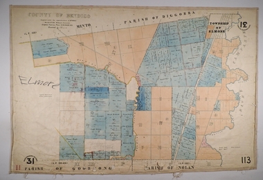
Map - ELMORE, 3/03/1875
... parish plan...Map: Elmore, County of Bendigo. Parish plan Paper canvas...MAP Bendigo parish plan Elmore W.H. Gregson Mr. Biers Map ...Map: Elmore, County of Bendigo. Parish plan Paper canvas backed. Compiled under the superintendence of Mr. BIERS November 12th W. H. GREGSON DRAUGHTSMAN Compiled from local plans 31.215.216.502.833. Examined by E. D. 27.11.74map, bendigo, parish plan, elmore, w.h. gregson, mr. biers -
 Bendigo Historical Society Inc.
Map - NEILBOROUGH, 6/12/1882
... parish plan...Map: Parish of Neilborough, County of Bendigo. Parish plan...MAP Bendigo parish plan Neilborough J A Morrison Jr. Harvey ...Map: Parish of Neilborough, County of Bendigo. Parish plan. J A Morrison Junior June 1877. Examined by ? Harvey 21/8/1877. Additions made by J V Walshe24/10/82. Examined by E D 39/10/82.map, bendigo, parish plan, neilborough, j a morrison jr., harvey, j v walshe -
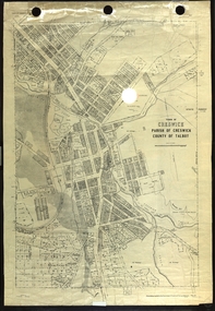 Federation University Historical Collection
Plan, Creswick, Parish of Creswick, County of Talbot, 1928, 1928
... parish plan...Parish Plan of Creswick showing Slaty Creek, Old Gold... creswick Eureka Terracotta Tile Co parish plan Parish Plan ...Parish Plan of Creswick showing Slaty Creek, Old Gold Workings, Police Reserve, Railway Station, Public Gardens, Sawpit Gully, Hospital Reserve, Nigh Soil Depot, Eureka Terracotta Tile COmpany, Creswick Creek, Forest COmmission, Roycroft's Racecreswick, eureka terracotta tile co, parish plan -
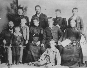 Federation University Historical Collection
Photograph - Photograph and Documents, Anne Beggs Sunter, Latta/Downing Family, Mount Helen
... parish plan... Family. .1) Parish Plan, including E. Latta, M. Fiscalini, R... j.u. smith j. davis parish plan john latta elizabeth latta ...The Federation University Mt Helen Campus was once the farm of John Latta and his wife Elizabeth Ann Dean. The couple married in 1867 and had three children at the time of John Latta's death (Elizabeth Ann b.1870; Mary b.1873; John b.1875). Elizabeth later married George Downing, and had another six children. The house was situated in the vicinity of the current Administration and Caro Conference Centre buildings, surrounded by an orchard, and a well under the current Albert Coates Building (Union Building). The land was purchased by the Ballarat School of Mines for their tertiary division from the Stapleton family.Various items relating to the Federation University Mount Helen Campus, and the early settlers on the land, the Latta Family. .1) Parish Plan, including E. Latta, M. Fiscalini, R. Wynne, R. Nixon, J.U. Smith, J. Davis .2) Part of a 1930s ordinance map showing Ballarat, Buninyong and Greenhill .3) Contour Map with the first two Mt Helen Campus buildings included. .4) Drawing a a proposed campus plan .5) Latta Family negativemount helen campus, latta family, greenhill, e. latta, m. fiscalini, r. wynne, r. nixon, j.u. smith, j. davis, parish plan, john latta, elizabeth latta, george downing, elezabeth downing, green hill, pontresina, abraham baxter, g. dean, market gardens, jim downing, bob thornton, j. hateley, martin fanning, toll keeper, anne beggs sunter -
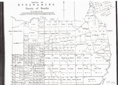 Whitehorse Historical Society Inc.
Document, Plan of Parish of Nunawading, 01/05/1864
... Plan of Parish of Nunawading...Copy of plan of Parish of Nunawading, County of Bourke... dandenong creek Copy of plan of Parish of Nunawading Copy of plan ...Copy of plan of Parish of NunawadingCopy of plan of Parish of Nunawading, County of Bourke, lithographed at the Office of Lands and Survey, Melbourne, 13th May, 1864 showing boundaries of Koonung, Mullum Mullum and Dandenong Creeks.Copy of plan of Parish of Nunawadingland subdivision, parish of nunawading, county of bourke, elgars special survey, koonung creek, mullum mullum creek, dandenong creek -
 Greensborough Historical Society
Poster - Planning Document, Shire of Diamond Valley et al, Subdivision Plan # 1044 - Parish of Nillumbik, County Bourke, Crown Allotment B Section 12, Eltham North, 1981-1987
... Subdivision Plan # 1044 - Parish of Nillumbik, County...Subdivision Plan # 1044 - Parish of Nillumbik, County...Subdivision Plan # 1044 - Parish of Nillumbik, County ...Subdivision Plan # 1044 - Parish of Nillumbik, County Bourke, Crown Allotment B Section 12, Eltham North. This subdivision plan includes Weidlich Road and St Clems Street. The developer for this subdivision is Taunton Developments and the Surveyors are Fisher Cleeland Turner & Dwyer Vic, Surveyors and Engineers.An example of hard copy subdivision plans from the Greensborough area. Mainly from the Shire of Diamond Valley era (1964-1994).Plan (single sided) mounted on heavy card. Stamped and handwritten Council permissions, dates and other details. subdivision plans, shire of diamond valley, taunton developments -
 Greensborough Historical Society
Poster - Planning Document, Shire of Diamond Valley et al, Subdivision Plan # 1026 - Parish of Nillumbik, County Bourke, Crown Allotment B Section 12, Eltham North, 1981-1984
... Subdivision Plan # 1026 - Parish of Nillumbik, County...Subdivision Plan # 1026 - Parish of Nillumbik, County...Subdivision Plan # 1026 - Parish of Nillumbik, County ...Subdivision Plan # 1026 - Parish of Nillumbik, County Bourke, Crown Allotment B Section 12, Eltham North. This subdivision plan includes Ryans Road (also known as Government Road) and St Clems Street. The developer for this subdivision is Taunton Developments and the Surveyors are Fisher Cleeland Turner & Dwyer Vic, Surveyors and Engineers.An example of hard copy subdivision plans from the Greensborough area. Mainly from the Shire of Diamond Valley era (1964-1994).Plan (single sided) mounted on heavy card. Stamped and handwritten Council permissions, dates and other details. subdivision plans, shire of diamond valley, taunton developments -
 Greensborough Historical Society
Poster - Planning Document, Shire of Diamond Valley et al, Subdivision Plan # 1018 - Parish of Nillumbik, County Bourke, Crown Allotment 4 Section 15, and Crown Allotment B Section 12, Eltham North, 1981-1982
... Subdivision Plan # 1018 - Parish of Nillumbik, County...Subdivision Plan # 1018 - Parish of Nillumbik, County...Subdivision Plan # 1018 - Parish of Nillumbik, County ...Subdivision Plan # 1018 - Parish of Nillumbik, County Bourke, Crown Allotment 4 Section 15, and Crown Allotment B Section 12, Eltham North. This subdivision plan includes Ryans Road (also known as Government Road) and St Clems Street. The developer for this subdivision is Taunton Developments and the Surveyors are Fisher Cleeland Turner & Dwyer Vic, Surveyors and Engineers.An example of hard copy subdivision plans from the Greensborough area. Mainly from the Shire of Diamond Valley era (1964-1994).Plan (single sided) mounted on heavy card. Stamped and handwritten Council permissions, dates and other details. subdivision plans, shire of diamond valley, taunton developments -
 Greensborough Historical Society
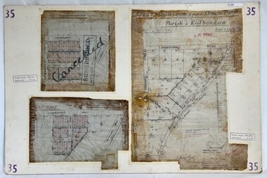
Poster - Planning Document, City of Heidelberg, Subdivision Plan # 35 - Parish of Keelbundoora, Crown Portion 16, Watsonia, 1918
... Subdivision Plan # 35 - Parish of Keelbundoora, Crown...Subdivision Plan # 35 Parish of Keelbundoora, Crown Portion...Subdivision Plan # 35 Parish of Keelbundoora, Crown Portion ...Subdivision Plan # 35 Parish of Keelbundoora, Crown Portion 16: 3 plans on one sheet. Plan 1: Lambourn Road, Boger Street, Kenmare Street, Greensborough Road, Devonshire Road, Watsonia (stamped "Superseded"). Plan 2: an update of plan 1. Plan 3: Also Lambourn Road, Boger Street, Kenmare Street, dated 1918, Shire of Heidelberg.An example of hard copy subdivision plans from the Greensborough area. Mainly from the Shire of Diamond Valley era (1964-1994).3 Plans (single sided) mounted on heavy card. Stamped and handwritten Council permissions, dates and other details. Plan 1 has been stamped in red "SUPERCEDED" and overwritten by hand "Cancelled".subdivision plans, city of heidelberg, greensborough, main street greensborough, shire of heidelberg, watsonia -
 Federation University Historical Collection
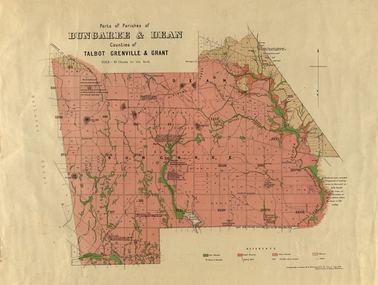
Plan, Bungaree and Dean Parish and Geological Plan, 1890, 07/1890
... Bungaree and Dean Parish and Geological Plan, 1890.... Bungaree and Dean Parish and Geological Plan, 1890 Plan Plan ...Ferdinand M. Krause was a Professor at the Ballarat School of Mines.Geological and Parish Map of parts of the Parishes of Bungaree and Dean in the Counties of Talbot, Grenville and Grant. The scale is 40 chains to one inch. bungaree, deen, krause, f.m. krause, musk creek, clarkes hill, badger hill, beale's reservoir, acquainted. -
 Greensborough Historical Society
Poster - Planning Document, City of Heidelberg, Subdivision Plan # 19 - Parish of Keelbundoora, Crown Portion 16, Watsonia "Black's subdivision', 1924
... Subdivision Plan # 19 - Parish of Keelbundoora, Crown...Subdivision Plan # 19 - Parish of Keelbundoora, Crown...Subdivision Plan # 19 - Parish of Keelbundoora, Crown ...Subdivision Plan # 19 - Parish of Keelbundoora, Crown Portion 16, Watsonia "Black's subdivision". This subdivision plan includes proposed street names which were later changed (e.g. Morwell Street (not Morwell Avenue) now called Greenwood Drive). Includes Lambourn Road, Black Street, Grace Street, Eden Avenue, High Street, Kenmare Street, Morwell Avenue, Greensborough Road, Mundy Street, Ladd Street.An example of hard copy subdivision plans from the Greensborough area. Mainly from the Shire of Diamond Valley era (1964-1994).Plan (single sided) mounted on heavy card. Stamped and handwritten Council permissions, dates and other details. subdivision plans, city of heidelberg, greensborough, main street greensborough, shire of heidelberg, watsonia, black family -
 Bendigo Historical Society Inc.
Map - SANDHURST SHEET 3, June 29th 1967
... Map: Sandhurst sheet 3. Parish plan.... 3. Parish plan. Map SANDHURST SHEET 3 ...Map: Sandhurst sheet 3. Parish plan.map, bendigo, city streets, sandhurst, early bendigo -
 Bendigo Historical Society Inc.
Map - SANDHURST SHEET 2, March 12th 1867
... Map: Sandhurst sheet 2 . Parish plan.... 2 . Parish plan. Map SANDHURST SHEET 2 ...Map: Sandhurst sheet 2 . Parish plan.map, bendigo, city streets, sandhurst, early bendigo