Showing 603 items matching "rail line"
-
 Orbost & District Historical Society
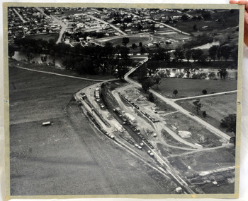
aerial photograph, 1970's
... The line was completely closed to freightage in 1987.The track infrastructure was dismantled in 1994 and has been redeveloped as the East Gippsland Rail Trail. railway photography orbost railway photography orbost A large black and white aerial photograph of Orbost Railway Station in the foreground and the Orbost township in the background. ...This photograph was taken prior to the closure of the Orbost -Bairnsdale freight line in 1987.The Orbost-Bairnsdale railway initially played a crucial role in developing agricultural industries in Gippsland as well as tourism. It opened in 1916 and operated until 1987, principally carrying timber and farming produce. In the early days of the railway's operation dedicated passenger trains ran but these ceased by the 1930s. The line was completely closed to freightage in 1987.The track infrastructure was dismantled in 1994 and has been redeveloped as the East Gippsland Rail Trail.A large black and white aerial photograph of Orbost Railway Station in the foreground and the Orbost township in the background. It has been pasted onto a piece of Masonite. railway photography orbost, railway photography orbost -
 Orbost & District Historical Society
railway stamps, c. 1916-1987
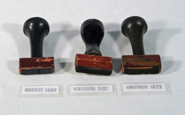
... This item is associated with the history of the Orbost-Bairnsdale railway line and therefore reflects the role that the rail line played in the social and economic history of Orbost. railway-stamp railway-history orbost-railway-line WAYGARA BRUTHEN ORBOST Three stamps used by Victorian Railways, for WAYGARA, BRUTHEN, and ORBOST stations. ...Used by station staff on the Bairnsdale to Orbost railway line which closed in 1987. The Bairnsdale-Orbost railway was opened in 1916 to serve the agricultural and timber industry. Because of the decline in traffic and heavy operating costs, the line was finally closed in August, 1987.This item is associated with the history of the Orbost-Bairnsdale railway line and therefore reflects the role that the rail line played in the social and economic history of Orbost.Three stamps used by Victorian Railways, for WAYGARA, BRUTHEN, and ORBOST stations. All stamps have black painted handles. The stamp is made of rubber and the handles are wood.WAYGARA BRUTHEN ORBOSTrailway-stamp railway-history orbost-railway-line -
 Orbost & District Historical Society
stamps, c. 1916-1987
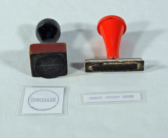
... This item is associated with the history of the Orbost-Bairnsdale railway line and therefore reflects the role that the rail line played in the social and economic history of Orbost. railway-history orbost-railway CANCELLED ORBOST FREIGHT DEPOT Two stamps, one with a black handle, one with red handle. ...Used by Victorian Railways at the Orbost Railway Station. The line to Orbost closed in 1987.This item is associated with the history of the Orbost-Bairnsdale railway line and therefore reflects the role that the rail line played in the social and economic history of Orbost.Two stamps, one with a black handle, one with red handle. One is square and has the word CANCELLED within a circle. The other is rectangular in shape and has the words ORBOST FREIGHT DEPOT. CANCELLED ORBOST FREIGHT DEPOTrailway-history orbost-railway -
 Orbost & District Historical Society
ticket voucher book, Victorian Railways Commission, c. 1939 - 1987
... This item is associated with the history of the Orbost-Bairnsdale railway line and therefore reflects the role that the rail line played in the social and economic history of Orbost. railway-history orbost-bairnsdale-railway-line TR88 Victorian Railways BRUTHEN 6879 STATION 7/1/1939. ...A ticket voucher book used on the railway line between Bairnsdale and Orbost which closed in 1987. Escept for special events, passenger trains ceased in 1937 and after that time, passengers wishing to travel by train had to take the good trains and be issued with this ticket. The train guard may have issued these tickets.This item is associated with the history of the Orbost-Bairnsdale railway line and therefore reflects the role that the rail line played in the social and economic history of Orbost.A Victorian Railways ticket voucher book. This is a tear-off ticket book, stapled at the left margin. It was used for passengers travelling on goods trains from Bruthen Railway Station.TR88 Victorian Railways BRUTHEN 6879 STATION 7/1/1939. In consideration of my being able to travel by the ......goods train on the 7/1/39 from BRUTHEN 6879 to NOWA NOWA, I hereby unertake ........................... etc.railway-history orbost-bairnsdale-railway-line -
 Orbost & District Historical Society
stamp holder and numbers, Victorian Government Railways, c. 1930s- 1980s
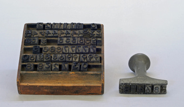
... The station was located on the west side of the Snowy River despite the town of Orbost being on the east side of the river, in order to save on the costs of a bridge over the river, which at the time had highly variable levels This item is associated with the history of the Orbost-Bairnsdale railway line and therefore reflects the role that the rail line played in the social and economic history of Orbost. railway-history orbost-bairnsdale-railway possibly V G R A stamp holder made of aluminium into which numbers and possibly letters can be inserted. ...Used on the Orbost-Bairnsdale railway line which closed in 1987. The Bairnsdale-Orbost railway was opened in 1916 to serve the agricultural and timber industry. Because of the decline in traffic and heavy operating costs, the line was finally closed in August, 1987. Orbost Railway Station was opened on Monday 10 April 1916 as the terminus of the Orbost railway line, and closed in 1987. The station was located on the west side of the Snowy River despite the town of Orbost being on the east side of the river, in order to save on the costs of a bridge over the river, which at the time had highly variable levels This item is associated with the history of the Orbost-Bairnsdale railway line and therefore reflects the role that the rail line played in the social and economic history of Orbost.A stamp holder made of aluminium into which numbers and possibly letters can be inserted. Also a square shallow wooden box containing numbers which are used with the stamp. The numbers appear to be made of rubber.possibly V G R railway-history orbost-bairnsdale-railway -
 Orbost & District Historical Society
railways envelope, Victorian Railways, c. 1970s-1980s
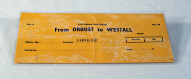
... This item is associated with the history of the Orbost-Bairnsdale railway line and therefore reflects the role that the rail line played in the social and economic history of Orbost. railway-history orbost-bairnsdale-railway 2498-78 VICTORIAN RAILWAYS From ORBOST to WESTALL Contents TIMBER An unused brown/buff coloured goods/freight consignment envelope used by Victorian Railways, this one for timber from Orbost to Westall. railways envelope Victorian Railways ...Used at Orbost railway station for the consignment of goods/freight, in this case, timber to Westall. The Bairnsdale-Orbost railway was opened in 1916 to serve the agricultural and timber industry. Because of the decline in traffic and heavy operating costs, the line was finally closed in August, 1987. Orbost Railway Station was opened on Monday 10 April 1916 as the terminus of the Orbost railway line, and closed in 1987. The station was located on the west side of the Snowy River despite the town of Orbost being on the east side of the river, in order to save on the costs of a bridge over the river, which at the time had highly variable levels. This item is associated with the history of the Orbost-Bairnsdale railway line and therefore reflects the role that the rail line played in the social and economic history of Orbost.An unused brown/buff coloured goods/freight consignment envelope used by Victorian Railways, this one for timber from Orbost to Westall. 2498-78 VICTORIAN RAILWAYS From ORBOST to WESTALL Contents TIMBER railway-history orbost-bairnsdale-railway -
 Orbost & District Historical Society
Victorian Railways pencil, Victorian Railways, c. 1960s-1980s
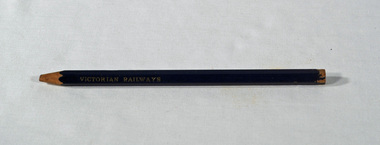
... This item is associated with the history of the Orbost-Bairnsdale railway line and therefore reflects the role that the rail line played in the social and economic history of Orbost. railway-history victorian-railways orbost-bairnsdale-railway VICTORIA RAILWAYS written in gold lettering Emperor, Made in Australia A thick, hexagonal shaped pencil made of wood, painted dark blue, containing blue graphite marker. ...Used by Victorian Railways at stations on the Orbost-Bairnsdale line. The Bairnsdale-Orbost railway was opened in 1916 to serve the agricultural and timber industry. Because of the decline in traffic and heavy operating costs, the line was finally closed in August, 1987. Orbost Railway Station was opened on Monday 10 April 1916 as the terminus of the Orbost railway line, and closed in 1987. The station was located on the west side of the Snowy River despite the town of Orbost being on the east side of the river, in order to save on the costs of a bridge over the river, which at the time had highly variable levels. This item is associated with the history of the Orbost-Bairnsdale railway line and therefore reflects the role that the rail line played in the social and economic history of Orbost.A thick, hexagonal shaped pencil made of wood, painted dark blue, containing blue graphite marker.VICTORIA RAILWAYS written in gold lettering Emperor, Made in Australia railway-history victorian-railways orbost-bairnsdale-railway -
 Orbost & District Historical Society
Victorian Railways remarks book, Victorian Railways, c. 1940s
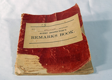
... This item is associated with the history of the Orbost-Bairnsdale railway line and therefore reflects the role that the rail line played in the social and economic history of Orbost. railway-history orbost-bairnsdale-railway VICTORIAN RAILWAYS Audit Inspectors Remarks Book, Orbost. ...Used at Orbost Railway Station, possibly by the Station Master, between 1944 and 1984. The Bairnsdale-Orbost railway was opened in 1916 to serve the agricultural and timber industry. Because of the decline in traffic and heavy operating costs, the line was finally closed in August, 1987. Orbost Railway Station was opened on Monday 10 April 1916 as the terminus of the Orbost railway line, and closed in 1987. The station was located on the west side of the Snowy River despite the town of Orbost being on the east side of the river, in order to save on the costs of a bridge over the river, which at the time had highly variable levels. This item is associated with the history of the Orbost-Bairnsdale railway line and therefore reflects the role that the rail line played in the social and economic history of Orbost.Book with a red cover. On the front cover VICTORIAN RAILWAYS Audit Inspectors Remarks Book, Orbost. Inside are numbered and lined pages with hand written information dating from 28/3/1944-13/8/1984, dated and signed by various station masters. Cover has a section missing from the bottom left.VICTORIAN RAILWAYS Audit Inspectors Remarks Book, Orbost.railway-history orbost-bairnsdale-railway -
 Orbost & District Historical Society
seal, 1928
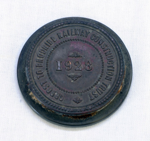
... This item is associated with the history of the Orbost-Bairnsdale railway line and therefore reflects the role that the rail line played in the social and economic history of Orbost. seal railway orbost-bairnsdale-railway A round copper disc with a metal seal on top. ...On 23 December an act was passed to authorise the construction by the State (Victoria) of a line of railway from Orbost to Brodribb. Even as late as 1913 the railway was still expected to go through Orbost and beyond. In the Orbost area a committee was formed called the Bairnsdale to Orbost Railway Trust. The business of the trust was to acquire the land necessary for the railway and levy a rate on the property owners. The other cost to the area wanting a railway was the guarantee against loss in working expenses of the railway, the Orbost Shire had to provide up to £3000 per annum. The line was never constructed and the Bairnsdale to Orbost Railway terminated on the western side of the Snowy River. This item is associated with the history of the Orbost-Bairnsdale railway line and therefore reflects the role that the rail line played in the social and economic history of Orbost.A round copper disc with a metal seal on top. "Orbost to Brodribb Railway Construction Trust - 1928"seal railway orbost-bairnsdale-railway -
 Frankston RSL Sub Branch
Rail, Steel
... Frankston RSL Sub Branch 183 Cranbourne Road Frankston mornington-peninsula A small section of steel railway line from the Thai Burma railway. Rail, Steel ...A small section of steel railway line from the Thai Burma railway. -
 Eltham District Historical Society Inc
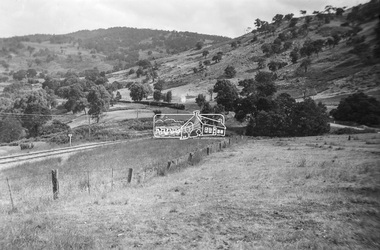
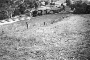
Photograph, George Burton Coop, Steam locomotive K-157 at Trawool Gap on the Tallarook-Mansfield-Alexandria branch line, c.1949
... rail trail. Photograph by George Burton Coop (George Coop's father). George Coop Collection K-157 K-Class Steam Locomotive (VR Newport Workshops) Trawool Gap Digital TIFF file Scan of Kopdak 620 black and white negative transparency Steam locomotive K-157 at Trawool Gap on the Tallarook-Mansfield-Alexandria branch line Photograph Photograph George Burton Coop ...This is a road and rail connection to Yea, Mansfield and Alexandra from Tallarook, Vic. The railway was converted many years ago into a long and spectacular rail trail. Photograph by George Burton Coop (George Coop's father).Digital TIFF file Scan of Kopdak 620 black and white negative transparencygeorge coop collection, k-157, k-class steam locomotive (vr newport workshops), trawool gap -
 Eltham District Historical Society Inc
Journal - Newsletter, Newsletter, No. 283 August 2025
... by Rachel Amel • Rail Tales – “The Beginning of Our Line” Part One by Terry Beaton • Rob Roy Revival by Jim Connor • “Little Eltham” farms • Remembrance Tower at Kangaroo Ground by Marguerite Marshall • Experience Eltham Cemetery – Restoring Honour: The Story of a Stolen Memorial by Julia Drew...by Rachel Amel • Rail Tales – “The Beginning of Our Line” Part One by Terry Beaton • Rob Roy Revival by Jim Connor • “Little Eltham” farms • Remembrance Tower at Kangaroo Ground by Marguerite Marshall • Experience Eltham Cemetery – Restoring Honour: The Story of a Stolen Memorial by Julia Drew The Shire of Eltham Historical Society was formed in October 1967. ...Contents: • War Memorials by Jim Connor • Next meeting – 2:00pm Saturday 9th August 2025 • Excursion – Saturday 6th September – St Katherine’s Church and Cemetery, St Helena • Eltham South Pre School by Jim Connor • “What is that on top of Kinder?” by Rachel Amel • Rail Tales – “The Beginning of Our Line” Part One by Terry Beaton • Rob Roy Revival by Jim Connor • “Little Eltham” farms • Remembrance Tower at Kangaroo Ground by Marguerite Marshall • Experience Eltham Cemetery – Restoring Honour: The Story of a Stolen Memorial by Julia DrewThe Shire of Eltham Historical Society was formed in October 1967. The first newsletter of the Society was issued May 1978 and has been published continuously ever since on a bi-monthly basis. With the cessation of the Shire of Eltham in late 1994, the Society's name was revised to Eltham District Historical Society and this name first appeared with issue No. 103, July 1995. The collection of the Society's newsletters provides a valuable resource on the history of the Society's activities, office bearers and committee members, guest speakers and subjects of historical interest pertinent to the former Shire of Eltham and the Eltham District.A4 newsletter distributed to members (Digital and A4 photocopy)newsletter, eltham district historical society -
 Eltham District Historical Society Inc
Journal - Newsletter, Newsletter, No. 284 October 2025
... Diamond Valley Local, Tuesday February 16th, 1954 • Meanjin by Jim Connor • Rail Tales – “The Beginning of Our Line” Part Two by Terry Beaton • Eltham Living and Learning Centre - 50th Anniversary ...Diamond Valley Local, Tuesday February 16th, 1954 • Meanjin by Jim Connor • Rail Tales – “The Beginning of Our Line” Part Two by Terry Beaton • Eltham Living and Learning Centre - 50th Anniversary The Shire of Eltham Historical Society was formed in October 1967. ...Contents: • War Memorial Tower at Kangaroo Ground by Jim Connor • Next meeting – 7.30pm Wednesday 8th October 2025 • Heritage Excursion - Saturday 1st November - Eltham Cemetery Tour • Fred looks back; article by Linley Hartley, Diamond Valley News c.1985 • Was woman found from well put in it? Diamond Valley Local, Tuesday February 16th, 1954 • Meanjin by Jim Connor • Rail Tales – “The Beginning of Our Line” Part Two by Terry Beaton • Eltham Living and Learning Centre - 50th Anniversary The Shire of Eltham Historical Society was formed in October 1967. The first newsletter of the Society was issued May 1978 and has been published continuously ever since on a bi-monthly basis. With the cessation of the Shire of Eltham in late 1994, the Society's name was revised to Eltham District Historical Society and this name first appeared with issue No. 103, July 1995. The collection of the Society's newsletters provides a valuable resource on the history of the Society's activities, office bearers and committee members, guest speakers and subjects of historical interest pertinent to the former Shire of Eltham and the Eltham District.A4 newsletter distributed to members (Digital and A4 photocopy)newsletter, eltham district historical society -
Glen Eira Historical Society
Article - OUTER CIRCLE RAILWAY
... They include ten black and white images of various aspects of the railway and three line maps. The first article is titled ‘Rail Link with the Past’. ...They include ten black and white images of various aspects of the railway and three line maps. The first article is titled ‘Rail Link with the Past’. ...This file contains five items: 1/Two copies of a document titled THE OUTER CIRCLE RAILWAY by the Royal Historical Society of Victoria and the Australian Railway Historical Society, Vic div. It details the history of the construction of the Outer Circle Railway and discussed expenses and other factors affecting the construction of the line. Notes compiled by R.K Whitehead, Research and Archives Officer Australian Railway Historical Society Victoria Division. The document includes three maps of the outer circle railway line. 2/Four newspaper articles detailing the history of the Outer Circle Railway Line. They include ten black and white images of various aspects of the railway and three line maps. The first article is titled ‘Rail Link with the Past’. In the COLLINGWOOD COURIER dated 07/10/1970, author unknown. The second article titled ‘Ghost trains of the Outer’ by Kenneth Joachim in the HERALD dated 18/04/1975. The third article is titled ‘Tracks in Time’ by Norman Thompson from NEWS, dated 13/02/1973. The fourth article is titled ‘Our Ghost Railway’ by John Townsley from the HERALD, dated 06/11/1974. 3/A letter from Victorian Railways Chief Estate Officer N.A Wigmore to the Honorary Secretary of the Caulfield Historical Society, dated 19/11/1975 regarding the leasing of land along the Outer Circle Railway Reserve from Dandenong Road to the Hughesdale Station. 4/Two copies of an article titled ‘Outer Circle Railway’ in the CAULFIELD HISTORICAL SOCIETY NEWSLETTER undated detailing the history of the outer circle line. The article includes a map of the section of the line in Caulfield. 5/A Photocopy of two images of train line locations on the Outer Circle Line. One on Warrigal Road, looking south from Ashburton dated 1936. The second is of the Black Bridge over Gardiners Creek dated 1935.outer circle railway, normanby road, caulfield station, outer circle line, rosstown junction railway, monash john, caulfield historical society, poath road, deepdene dasher, ashby dasher, dandenong road, gippsy goods, mallee root mercury, outer circle railway reserve, railway lines, railway stations, steam trains -
Glen Eira Historical Society
Article - Rosstown Railway
... The review explains the purpose of the Rail Trail with a brief narrative of the history behind Rosstown Sugar Mill Railway line. ...The review explains the purpose of the Rail Trail with a brief narrative of the history behind Rosstown Sugar Mill Railway line. ...This file contains three items: 1/A review of the ROSSTOWN RAIL TRAIL from LIVING IN GLEN EIRA, vol. 11, 2004, Issue 4, no. 25, date and author unknown. The review explains the purpose of the Rail Trail with a brief narrative of the history behind Rosstown Sugar Mill Railway line. Concluding with information on the location of the Trail and the expected time required to walk the entire track included in the review is a map of the Rail Trail, which marks significant sites along the trail with historic pictures. 2/A newspaper article from THE AGE, dated Tuesday 21/10/1980 and written by Iola Matthews, reporting on the circumstances that led to the publication of the book RETURN TO ROSSTOWN written by Des Jowett and Ian Weickhardt. The article begins with a brief biography of the authors before moving into details of the book’s content, providing a further biography of W. Murray Ross which includes information on his financial ventures – particularly the Rosstown Rail – his marriage and children. The article includes a black and white photograph of Weickhardt and Jowett walking along the route of the railway line, an illustration of the Rosstown sugar works and a map of the area surrounding the site of the mill. 3/Three photocopies of a black and white illustration of the Rosstown sugar works from the east, undated and artist unknown.rosstown rail trail, rosstown, ross william, ross w. murray, ross murray, sugar beet mills, mills, elsternwick, land transport, railways, railway lines, railway routes, carnegie neville street, carnegie miller street, factories, market gardens, horticulture, peat, soils, land forms, topography, geology, civic issues, cone sugar industry, elsternwick plaza, elsternwick, glenhuntly road, parks and reserves, ee gunn reserve, caulfield racecourse, sportsgrounds, caulfield, carnegie, riddell parade, clarence street, aileen avenue, princes park, dover street, marara road, oakleigh road, rosanna street, murrumbeena crescent, north road, kooyong road, hawthorn road, booran road, koornang road, poath road, warragul road, railway platforms, railway buildings, bambra road, swamps, landforms, landfill, council landfill, railway bridges, bridges, railway underpasses, sporting clubs, tennis clubs, bowls clubs, rosstown railway, rosanna street reserve, maps, railway maps, living in glen eira, weickhardt ian, jowett des, caulfield south, curraweena road, oakleigh, caulfield technical school, return to rosstown, beet sugar industry, crops, land booms, land development and subdivisions, bent thomas, fink benjamin, sugar works, rosstown hotel, oamdenong road, rosstown dry cleaners, shops, rosstown road, rosstown plate, people by circumstance, migrants, accountants, occupations, professionals, the grange, real estate, grange road, financial agents, judges, rosstown estate, financial trouble, rabbit preserving, breweries, political debates, political issues, political electorates, politics, political science, debt, financial loans, court procedures, court cases, legal events and activities, malleson and riggall, widowers, seabeach railway, economics, economic deadline, depression 1890s, economic crash, mortgages, divorce, social problems, poverty, ross claude, ross roderick, world war 1914-1918, wars, military history, servicemen, australian flying corps, engineers, caulfield council, swagmen, homelessness, glenhuntly road, glenhuntly road tram, woornack road, leila road, wild cherry road, melten avenue, illustrations, steam trains, trains, horse and cart, horse-drawn transport, railway stations -
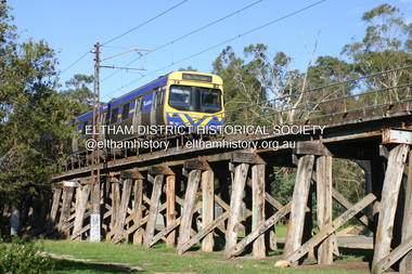 Eltham District Historical Society Inc
Photograph - Digital Photograph, Alan King, Eltham Railway Trestle Bridge, 28 December 2007
... Opened in 1902, it is also one of Victoria’s very few timber rail bridges that still carries trains.1 The bridge is part of the railway line extension from Heidelberg - extended to Hurstbridge in 1912. ...Opened in 1902, it is also one of Victoria’s very few timber rail bridges that still carries trains.1 The bridge is part of the railway line extension from Heidelberg - extended to Hurstbridge in 1912. ...Covered under National Trust of Australia (Victoria) State Significance and Heritage Overlay, Nillumbik Planning Scheme. Published: Nillumbik Now and Then / Marguerite Marshall 2008; photographs Alan King with Marguerite Marshall.; p103 The Eltham railway trestle bridge is the only one of its kind still regularly used in Melbourne’s metropolitan railway network. Opened in 1902, it is also one of Victoria’s very few timber rail bridges that still carries trains.1 The bridge is part of the railway line extension from Heidelberg - extended to Hurstbridge in 1912. This extension resulted in one of the greatest social changes experienced in Eltham Shire, as it considerably lessened its isolation attracting tourists, artists and suburban commuters particularly after World War Two.2 The bridge has been classified by the National Trust as historically, scientifically, aesthetically and socially significant at state level. But this has not always been recognised, and in 1977, locals fought to save it from destruction. The Victorian Railways proposed to replace the bridge with an earth embankment and large culverts to avoid maintenance problems and fire. This was rejected by the Eltham Council who protested that the bridge helped maintain the area’s rural character, historic link and beauty, as well as avoiding possible serious flooding on the flood plain if a culvert was blocked. The bridge stands as part of a National Trust classified landscape which includes the Alistair Knox Park, named after the local conservationist and architect who helped to make Eltham famous for its mud-brick houses. The landscape includes tall and spreading manna gums and candlebarks, and the historic Shillinglaw Cottage. Artist Walter Withers, one of the Heidelberg School of painters, painted the bridge early in the 20th century. The 38 span single-track railway bridge over creek and road has 34 timber-beam spans and four steel-joist spans, supported by four-pile timber piers and timber abutments. It has almost 200m of timber deck. All of the timbers have been replaced over the years, but the only change to the bridge’s character was the addition of pylons and wiring for electric trains in 1923. A petition for a railway to the shire was first made in 1883. A large deputation of local citizens to the Commissioner of Railways proposed a route passing through Alphington to midway between Greensborough and Eltham up the Diamond Creek valley towards Queenstown and Kinglake. As a result the Princes Bridge-Heidelberg Railway was opened in 1888. From 1888 locals demanded a railway extension. Kangaroo Ground farmers in particular, led by Shire Councillor and Member for Evelyn, Ewen Cameron, said it would assist local farmers and orchardists send their produce to the Melbourne market. In 1890, before the severe economic Depression, an extension of the line to Hurst’s Bridge (now Hurstbridge) was included in a new Railways Bill. The parliamentary delegations were regaled with a banquet at Hurst’s barn and entertained by the Diamond Creek Brass Band, but the extension was abandoned when the Depression struck in 1892-1893. The extension of the railway to Eltham, completed in 1902, was one of the few built in those hard times. That is why the Eltham timber-trestle railway bridge is a rare example of a broad-gauge rail bridge constructed between 1893 and 1910. At the opening, despite persistent drizzle, 300 children waving flags and banners were among the large crowd welcoming the first train, carrying official dignitaries, to Eltham. It had taken 24 years to bring the railway to Eltham. From then Eltham became a popular destination for outings. Mr Orford of Eltham recalled that after the railway came to Eltham ‘the craze for picnics on weekends and holidays began…. During the wattle season, wattle trains came to Eltham frequently. The visitors roamed the creek pulling great armfuls of wattle blossom to take back with them to Melbourne’.3 In 1926 the railway line was electrified as part of the metropolitan rail network. But the Victorian Railways decided not to complete the formerly planned Diamond Valley Railway to Queenstown (now St Andrews) and Kinglake.This collection of almost 130 photos about places and people within the Shire of Nillumbik, an urban and rural municipality in Melbourne's north, contributes to an understanding of the history of the Shire. Published in 2008 immediately prior to the Black Saturday bushfires of February 7, 2009, it documents sites that were impacted, and in some cases destroyed by the fires. It includes photographs taken especially for the publication, creating a unique time capsule representing the Shire in the early 21st century. It remains the most recent comprehenesive publication devoted to the Shire's history connecting local residents to the past. nillumbik now and then (marshall-king) collection, eltham railway trestle bridge, eltham trestle bridge -
 Bendigo Historical Society Inc.
Film - HUGH ENNES COLLECTION: VIDEO CLIPS ON A DVD
... Crossing at Buckrabanyule with rail motor from Sea Lake. Wirths Circus passing home. Spraying of line for weeds. ...Crossing at Buckrabanyule with rail motor from Sea Lake. Wirths Circus passing home. Spraying of line for weeds. ...The Hugh Ennes collection. A number of video clips on a DVD. the subject list on the DVD: J.D.C. McLean stock special. Crossing at Buckrabanyule with rail motor from Sea Lake. Wirths Circus passing home. Spraying of line for weeds. Rail derailment between Buckrabanyule and Wychitella. Puffing Billy coming into Upper Ferntree Gully.australia, history -
 The Beechworth Burke Museum
Photograph
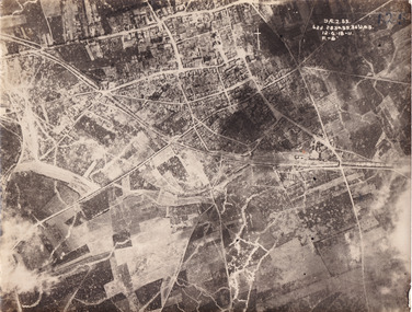
... line of fortified trenches, stretching from the North Sea to the Swiss frontier with France. The First Battle of Villers-Bretonneux occurred between 30 March - 5 April 1918. It took place during Operation Michael, part of the German Spring Offensive on the Western Front. The offensive began against the British Fifth Army and the Third Army on the Somme, and pushed back the British and French reinforcements on the north side of the Somme. The capture of Villers-Bretonneux, close to Amiens, a strategically important road and rail...line of fortified trenches, stretching from the North Sea to the Swiss frontier with France. The First Battle of Villers-Bretonneux occurred between 30 March - 5 April 1918. It took place during Operation Michael, part of the German Spring Offensive on the Western Front. The offensive began against the British Fifth Army and the Third Army on the Somme, and pushed back the British and French reinforcements on the north side of the Somme. The capture of Villers-Bretonneux, close to Amiens, a strategically important road and rail ...Taken some time between 1914-18, the photograph depicts an aerial view of Villers-Bretonneux in France, a region which was part of the Western Front during World War I. The image mostly shows rural landscape. The Western Front was the main theatre of war during World War I. Following the outbreak of war in August 1914, the German Army opened the Western Front by invading Luxembourg and Belgium, then gaining military control of important industrial regions in France. The German advance was halted with the Battle of the Marne. Following the Race to the Sea, both the French-British and German armies dug in along a meandering line of fortified trenches, stretching from the North Sea to the Swiss frontier with France. The First Battle of Villers-Bretonneux occurred between 30 March - 5 April 1918. It took place during Operation Michael, part of the German Spring Offensive on the Western Front. The offensive began against the British Fifth Army and the Third Army on the Somme, and pushed back the British and French reinforcements on the north side of the Somme. The capture of Villers-Bretonneux, close to Amiens, a strategically important road and rail-junction, would have brought the Germans within artillery-range. In late March, troops from the Australian Imperial Force were brought south from Belgium as reinforcements to help shore up the line. In early April, the Germans launched an attack to capture Villers-Bretonneux. After a determined defence by British and Australian troops, the attackers were close to success until a counter-attack by the 9th Australian Infantry Brigade and British troops late in the afternoon of 4 April restored the situation and halted the German advance on Amiens. The Second Battle of Villers-Bretonneux occurred between 24 - 27 April 1918, during the German Spring Offensive to the east of Amiens. It is notable for being the first occasion on which tanks fought against each other. A counter-attack by two Australian brigades and a British brigade during the night of 24 April partly surrounded Villers-Bretonneux, and on 25 April, the town was recaptured. On 26 April, the role of the Moroccan division of the French army was crucial in pushing back German units. Australian, British and French troops nearly restored the original front line by 27 April.The record is historically significant due to its connection to World War I. This conflict is integral to Australian culture as it was the single greatest loss of life and the greatest repatriation of casualties in the country's history. Australia’s involvement in the First World War began when the Australian government established the Australian Imperial Force (AIF) in August 1914. Immediately, men were recruited to serve the British Empire in the Middle East and on the Western Front. Additionally, the record's significance is enhanced by its depiction of Villers-Bretonneux. The battles that occurred in this town during World War I are especially historically significant to Australia as this is where the Australian Imperial Force had one their greatest World War I victories. An Australian flag still flies over Villers-Bretonneux in the present. Furthermore, a plaque outside the Villers-Bretonneux Town Hall recounts the battles fought to save the town in 1918. Kangaroos feature over the entrance to the Town Hall, and the main street is named Rue de Melbourne. More officially, recognition of the significance of the battle in Villers-Bretonneux is found at the Australian National Memorial, which was built just outside the town. It commemorates all Australians who fought in France and Belgium and includes the names of 10,772 who died in France and have no known grave. Each year, a small ceremony is held at the memorial to mark the sacrifice made by the soldiers. Lastly, the record has strong research potential. This is due to the ongoing public and scholarly interest in war, history, and especially the ANZAC legend, which is commemorated annually on 25 April, known as ANZAC Day.Sepia rectangular photograph printed on matte photographic paper.Obverse: yAE.2.35. / 125 / 62d.2834.35.36.VA.5. / 12.G.18-11 / F.-(?)" /military album, wwi, world war i, villers-bretonneux, australian imperial force, aif, france, war, army, conflict, germany, 1918, battle -
 Greensborough Historical Society
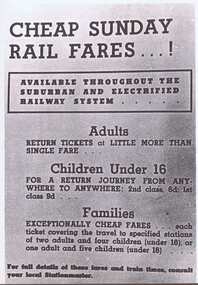
Advertisement - Digital image, Rail notices 1950s, 1950s
... These are notices to variations in rail services. husrstbridge railway line Digital copy of newspaper advertisement. ...These advertisements were collected from a local newspaper. These are notices to variations in rail services.Digital copy of newspaper advertisement.husrstbridge railway line -
Greensborough Historical Society
DVD, Channel 5 Productions et al, The Inner Circle Railway Line, 1888o
... line (later electrified) in Melbourne, Australia. It served the inner-northern suburbs of Parkville, Carlton North, Fitzroy North, and Fitzroy and later expanded to outer suburbs. It opened in 1888. In this video, the viewer is taken on a train journey around the Melbourne rail...Original footage of Melbourne's railways. melbourne rail network transportation railways 1 x DVD in black case. DVD of approx 43 minutes. The Inner Circle Railway Line DVD Channel 5 Productions Transport Video International ...The Inner Circle was a steam era suburban railway line (later electrified) in Melbourne, Australia. It served the inner-northern suburbs of Parkville, Carlton North, Fitzroy North, and Fitzroy and later expanded to outer suburbs. It opened in 1888. In this video, the viewer is taken on a train journey around the Melbourne rail network and also looks at the stations and lines that have since closed.Original footage of Melbourne's railways.1 x DVD in black case. DVD of approx 43 minutes.melbourne rail network, transportation, railways -
 Greensborough Historical Society
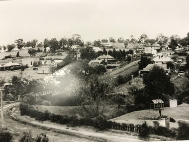
Photograph, Main Road bridge looking to township of Greensborough, 1929c
... line and the rather undeveloped roadside area of the park. Looking up Main Street we see the old Chapman house at the corner of Poulter Avenue and some newer houses below this. The stone river bridge appears to be only a single lane wide and the road approaching the bridge is unsealed. The rail...line and the rather undeveloped roadside area of the park. Looking up Main Street we see the old Chapman house at the corner of Poulter Avenue and some newer houses below this. The stone river bridge appears to be only a single lane wide and the road approaching the bridge is unsealed. The rail ...View of Main Street Greensborough from Partington's Hill including Plenty River bridge and Marble Hall on corner of Carter Street (now Para Road) and Main Street. This view of Greensborough Park shows the old pan toilets, the hawthorn fence line and the rather undeveloped roadside area of the park. Looking up Main Street we see the old Chapman house at the corner of Poulter Avenue and some newer houses below this. The stone river bridge appears to be only a single lane wide and the road approaching the bridge is unsealed. The rail bridge shows evidence of soot from steam trains and at the extreme left of picture the two concrete buildings indicate the line had been electrified. This occurred in 1923. Sparse housing is seen in the Flintoff Street and Grimshaw Street area.Part of a collection of photographic enlargements of views of Greensborough in the early 1900s.Black and white enlargement of photographic imagemain street greensborough, marble hall, greensborough railway, chapman house, greensborough park, poulter avenue greensborough, carter street, para road -
 Greensborough Historical Society
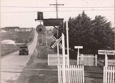
Photograph - Photograph - Digital Image, Grimshaw Street level crossing 1950s, 1950o
... A black and white photograph of Grimshaw Street rail crossing, Greensborough mid 1950s; and the removed crossing lights from the 1960s. The train line was lowered in the 1970s to remove the level crossing....Greensborough Historical Society 34A Glenauburn Road Lower Plenty Lower Plenty melbourne A black and white photograph of Grimshaw Street rail crossing, Greensborough mid 1950s; and the removed crossing lights from the 1960s. The train line was lowered in the 1970s to remove the level crossing. grimshaw street greensborough watsonia station rail crossing greensborough Digital copy of one black and white photograph, and one colour photograph Grimshaw Street level crossing 1950s Photograph Photograph - Digital Image ...A black and white photograph of Grimshaw Street rail crossing, Greensborough mid 1950s; and the removed crossing lights from the 1960s. The train line was lowered in the 1970s to remove the level crossing.Digital copy of one black and white photograph, and one colour photographgrimshaw street greensborough, watsonia station, rail crossing greensborough -
 Halls Gap & Grampians Historical Society
Photograph - B/W
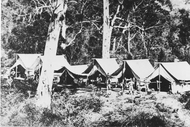
... Railway survey camp 1880 After choosing the route, the rail survey was undertaken followed by the construction of the line in less than a year. ...Halls Gap & Grampians Historical Society Centennial Hall 117-119 Grampians Road Halls Gap grampians Railway survey camp 1880 After choosing the route, the rail survey was undertaken followed by the construction of the line in less than a year. ...Railway survey camp 1880 After choosing the route, the rail survey was undertaken followed by the construction of the line in less than a year. By Nov 1881 access by rail for Heatherlie to Melbourne was a reality Railway survey camp Heatherlie quarry; 11 men, some standing, some reclining in front of 6 army style tentsstructures, tents -
 Eltham District Historical Society Inc
Booklet - Newspaper articles, Christmas Day Storm, 2011
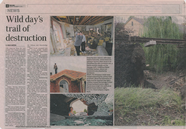
... line. Wild day's trail of destruction, by Reid sexton, The Age, Tuesday, December 21, 2011, p4 Storm toll sparks rail safety fear, Reid Saxton, The Age, Tuesday, December 21, 2011, p5...line. Wild day's trail of destruction, by Reid sexton, The Age, Tuesday, December 21, 2011, p4 Storm toll sparks rail safety fear, Reid Saxton, The Age, Tuesday, December 21, 2011, p5 storm floods flooding christmas day hurstbridge railway line 2 newspaper articles Christmas Day Storm Booklet Newspaper articles ...A severe storm with damaging hail, rain and flooding impacted Melbourne on 25 December 2011 with particular damage to Eltham and Hurstbridge areas. The storm caused destablisation of parts of the Hurstbridge railway line. Wild day's trail of destruction, by Reid sexton, The Age, Tuesday, December 21, 2011, p4 Storm toll sparks rail safety fear, Reid Saxton, The Age, Tuesday, December 21, 2011, p52 newspaper articlesstorm, floods, flooding, christmas day, hurstbridge railway line -
 Eltham District Historical Society Inc
Photograph, Peter Pidgeon, Birch Cottage, Eltham-Yarra Glen Road, Christmas Hills, 27 September 2018, 2018
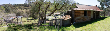
... lined with 1938 Lysaght Queens Head Australia galvanised sheet iron) and a paling clad gabled out-house. Timber outbuildings of differing eras are to the north-west of the house, with pole framing and paling infill construction and Redcliffe brand corrugated iron. Post and rail...lined with 1938 Lysaght Queens Head Australia galvanised sheet iron) and a paling clad gabled out-house. Timber outbuildings of differing eras are to the north-west of the house, with pole framing and paling infill construction and Redcliffe brand corrugated iron. Post and rail ...Originally built by John Hill, a shoemaker at Kangaroo Ground around 1878. In the late 1970s when our Society was the Shire of Eltham Historical Society, an offer was made to the Society regarding use of an old cottage at Christmas Hills. The cottage sat beside Watsons Creek just outside the then Shire of Eltham but following municipal restructuring it now lies within the Shire of Nillumbik. For various reasons the offer ultimately lapsed. At that time some research on the cottage was carried out for the Society by Keith Chappel as part of a larger research project that he was doing. Keith’s notes were taken from Lands Department records and showed that the property was the subject of a permissive occupancy of Crown land comprising the creek reserve. In 1903 a Miner’s Right of one acre in area was granted to Edwin Samuel Birch. In 1907 Birch applied to purchase this land but was unable to because it was part of the creek reserve. The documents show that the cottage existed at that time. Upon Birch’s death in 1932, his daughter, Honor Mary Birch was granted a permit to occupy the residence. Honor Mary Birch, known as Nora, was born 1900, the daughter of Edwin Samuel Birch and Honor (nee Young). In 1939 she married George Henry Williams (aka Henry). Honor died 8 July 1976. Her siblings were Margaret Martin (dec), Bert Birch and Brigidene Brinkkotter. In her will she gave and bequeathed “all the improvements on the land held by me at Christmas Hills under Permissive Occupancy from the Department of Land and Survey consisting of the house property thereon and all the contents of the said house to my nephew Brian Joseph Martin of Christmas Hills aforesaid farmer”. The will described the property as a four room, five square house, about 100 years old with enclosed verandah, including kitchen, combined lounge dining room, bedroom and store room; built of ‘bush slabs’ with a corrugated iron roof. A dairy had been erected in 1935. After her death, the property was acquired by the Melbourne Metropolitan Board of Works in 1978. The property is listed on the Victorian Heritage Database HO200-Hill, later Birch farm complex, 945 Eltham-Yarra Glen Road, Watsons Creek and described as: The house has a steep but simply gabled roof form clad with corrugated iron, vertical adzed hardwood slab front wall construction, split palings to the gable ends; rubble freestone chimney at one end (with added gsi flue), pole-framed Graeme Butler & Associates, 2006: 101 Shire of Nillurnbik Planning Scheme Amendment C13 Heritage Assessments verandah (rebuilt?); six-pane double-hung sash windows; T&G bead-edge boarded ledged & braced door; and paling clad rooms added at verandah ends. A slab-clad large fireplace is at the north corner of the house, with a gsi upper cladding added and an internal lining of rubble stone. The rear facade is different construction, being drop-slab, and sits beneath a rear skillion addition to the main gabled form: this may be more recent construction. The house appears to have been once set up for public display and may have been recreated in part for that purpose. Outbuildings are reached by a track along the east side of the house, including what may have been a creamery (typical standard inter-war design clad with corrugated iron and lined with 1938 Lysaght Queens Head Australia galvanised sheet iron) and a paling clad gabled out-house. Timber outbuildings of differing eras are to the north-west of the house, with pole framing and paling infill construction and Redcliffe brand corrugated iron. Post and rail (front) and split paling (rear) fence remnants line the front boundary. Pepper trees part of house yard landscape49 born digital images (includes one panoramic stitch and nine frames from drone video)birch cottage, christmas hills, early settlers, edwin samuel birch, honor mary birch, john hill, watsons creek -
 Eltham District Historical Society Inc
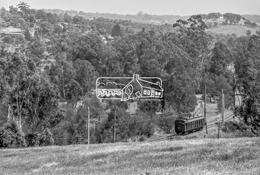
Photograph, George Coop, Single Motor Carriage (Red Rattler) Tait train, possibly 471M, heading for Eltham near Allendale Road, Diamond Creek, c.December 1980, 1980
... 471m, allendale road, challenger street, derailment guard rail, diamond creek, hurstbridge line, price court, red rattler, red rattler single carriage, single motor carriage, tait train...On the track in the straight section heading northwest are two small bridges where the track crosses the Diamond Creek, each fitted with derailment guard rails to prevent severe derailments should a train come off the tracks whilst crossing the culverts. 471m, allendale road, challenger street, derailment guard rail, diamond creek, hurstbridge line, price court, red rattler, red rattler single carriage, single motor carriage, tait train Digital TIFF file Scan of 35mm Ilford FP4 black and white transparency Single Motor Carriage (Red Rattler) Tait train, possibly 471M, heading for Eltham near Allendale Road, Diamond Creek, c.December 1980 Photograph George Coop ...View is looking northwest from the hillside just north of Allendale Road. The long rectangular house in the upper left is No. 22 Challenger Street, Diamond Creek, right at the sharp turn into Price Court. On the track in the straight section heading northwest are two small bridges where the track crosses the Diamond Creek, each fitted with derailment guard rails to prevent severe derailments should a train come off the tracks whilst crossing the culverts. Digital TIFF file Scan of 35mm Ilford FP4 black and white transparency471m, allendale road, challenger street, derailment guard rail, diamond creek, hurstbridge line, price court, red rattler, red rattler single carriage, single motor carriage, tait train -
 Eltham District Historical Society Inc
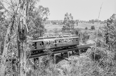
Photograph, George Coop, Single Motor Carriage 471M (Red Rattler) Tait train crossing over the Diamond Creek just north of Allendale Road, c.December 1980, 1980
... 471m, allendale road, derailment guard rail, diamond creek, hurstbridge line, railway bridge, red rattler, red rattler single carriage, single motor carriage, tait train...Eltham District Historical Society Inc 728 Main Rd Eltham melbourne 471m, allendale road, derailment guard rail, diamond creek, hurstbridge line, railway bridge, red rattler, red rattler single carriage, single motor carriage, tait train Digital TIFF file Scan of 35mm Ilford FP4 black and white transparency Single Motor Carriage 471M (Red Rattler) Tait train crossing over the Diamond Creek just north of Allendale Road, c.December 1980 Photograph George Coop ...Digital TIFF file Scan of 35mm Ilford FP4 black and white transparency471m, allendale road, derailment guard rail, diamond creek, hurstbridge line, railway bridge, red rattler, red rattler single carriage, single motor carriage, tait train -
 Eltham District Historical Society Inc
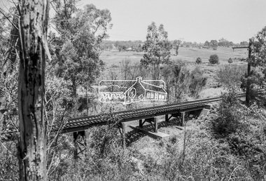
Photograph, George Coop, Railway bridge crossing over the Diamond Creek just north of Allendale Road, c.December 1980, 1980
... allendale road, derailment guard rail, diamond creek, hurstbridge line, railway bridge...Eltham District Historical Society Inc 728 Main Rd Eltham melbourne allendale road, derailment guard rail, diamond creek, hurstbridge line, railway bridge Digital TIFF file Scan of 35mm Ilford FP4 black and white transparency Railway bridge crossing over the Diamond Creek just north of Allendale Road, c.December 1980 Photograph George Coop ...Digital TIFF file Scan of 35mm Ilford FP4 black and white transparencyallendale road, derailment guard rail, diamond creek, hurstbridge line, railway bridge -
 Eltham District Historical Society Inc
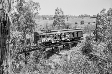
Photograph, George Coop, Single Motor Carriage 471M (Red Rattler) Tait train heading for Eltham crossing over the Diamond Creek just north of Allendale Road, c.December 1980, 1980
... 471m, allendale road, derailment guard rail, diamond creek, hurstbridge line, railway bridge, red rattler, red rattler single carriage, single motor carriage, tait train...Eltham District Historical Society Inc 728 Main Rd Eltham melbourne 471m, allendale road, derailment guard rail, diamond creek, hurstbridge line, railway bridge, red rattler, red rattler single carriage, single motor carriage, tait train Digital TIFF file Scan of 35mm Ilford FP4 black and white transparency Single Motor Carriage 471M (Red Rattler) Tait train heading for Eltham crossing over the Diamond Creek just north of Allendale Road, c.December 1980 Photograph George Coop ...Digital TIFF file Scan of 35mm Ilford FP4 black and white transparency471m, allendale road, derailment guard rail, diamond creek, hurstbridge line, railway bridge, red rattler, red rattler single carriage, single motor carriage, tait train