Showing 11853 items
matching roads for victoria
-
 Tarnagulla History Archive
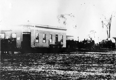
Photograph: The Newbridge Hotel, The Newbridge Hotel, 1908
... . Muddy road in foreground. Newbridge, Victoria, Australia... at right. Muddy road in foreground. Newbridge, Victoria, Australia ...Murray Comrie Collection. A monochrome photograph, image depicting a weatherboard hotel building with people seated in several carriages at right. Muddy road in foreground. Newbridge, Victoria, Australia. This is a poor quality, very dark copy of an older original. Copy probably made by Murray Comrie in the 1960s.newbridge, hotel, people -
 Bendigo Historical Society Inc.
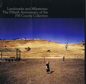
Book - LA TROBE UNIVERSITY BENDIGO COLLECTION: LANDMARKS AND MILESTONES:THE FIFTIETH ANNIVERSARY OF THE FM
... Trobe Universiy Edwards Road, Flora Hill, Victoria 3550... Faculty Bendigo, La Trobe Universiy Edwards Road, Flora Hill ...Two copies of the booklet titled "Landmarks and Milestones: The Fiftieth Anniversary of the FM Courtis Collection". Bendigo Art Gallery 5 July - 10 August 2008. Education Faculty Bendigo, La Trobe Universiy Edwards Road, Flora Hill, Victoria 3550, Australia. Published 2008. On the front of the booklet is a photo of an outdoor scene with children flying kites. Within the book is a type written article describing the art collection.bendigo, education, bendigo teachers' college, la trobe university bendigo collection, collection, art collection, person, male, individual, fm courtis collection, bendigo art gallery, art works, artist, catalogue, art catalogue, exhibition, art education, art history, landscapes, mr. f. m. courtis -
 Kew Historical Society Inc
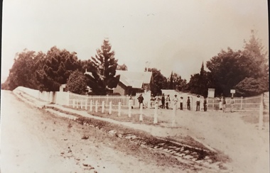
Photograph - Entrance to Boroondara General Cemetery
... an unusual triangular reserve bounded by High Street, Park Hill Road... triangular reserve bounded by High Street, Park Hill Road ...Boroondara Cemetery, established in 1858, is within an unusual triangular reserve bounded by High Street, Park Hill Road and Victoria Park, Kew. The caretaker's lodge and administrative office (1860 designed by Charles Vickers, additions, 1866-1899 by Albert Purchas) form a picturesque two-storey brick structure with a slate roof and clock tower. A rotunda or shelter (1890, Albert Purchas) is located in the centre of the cemetery: this has an octagonal hipped roof with fish scale slates and a decorative brick base with a tessellated floor and timber seating. The cemetery is surrounded by a 2.7 metre high ornamental red brick wall (1895-96, Albert Purchas) with some sections of vertical iron palisades between brick pillars. Albert Purchas was a prominent Melbourne architect who was the Secretary of the Melbourne General Cemetery from 1852 to 1907 and Chairman of the Boroondara Cemetery Board of Trustees from 1867 to 1909. He made a significant contribution to the design of the Boroondara Cemetery. (Source: Heritage Victoria)This photograph is one of the earliest known photographs of the cemetery, showing the early plantings and fences.Later print copy of an undated original photographic positive of the entrance to the Boroondara General (Kew) Cemetery. The Cemetery had been opened in 1855. This view is from Bulleen Road (now High Street) showing a group of 12 or 13 men standing in a line outside the entrance. At this time, the clocktower and high brick fence had not been constructed, but the trees have reached a substantial heightPencil inscription on reverse - "Boroondara Cemetery Entrance 1862"boroondara general (kew) cemetery, cemeteries -- melbourne (vic.) -
 Lakes Entrance Historical Society
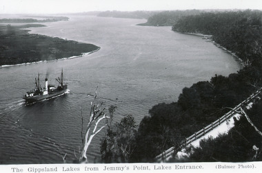
Postcard - SSTambar, c1930
... Kalimna hill with Jemmy's Point road in foreground. Lakes Entrance... from Kalimna hill with Jemmy's Point road in foreground. Lakes ...Black and white postcard of SS Tambar in the channel, heading westward toward Nungurner and Metung. Photo taken from Kalimna hill with Jemmy's Point road in foreground. Lakes Entrance VictoriaGippsland Lakes from Jemmy's Point, Lakes Entrance.ships and shipping, waterways -
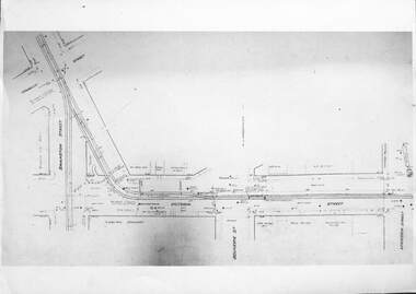 Melbourne Tram Museum
Drawing - Linking Essendon Tram lines, Melbourne & Metropolitan Tramways Board (MMTB), 1926
... connection between Haymarket (Flemington Road), Elizabeth St... connection between Haymarket (Flemington Road), Elizabeth St ...Set of three images of the track plans for the temporary connection between Haymarket (Flemington Road), Elizabeth St, Victoria St, and Swanston St to enable the transfer of electric trams between Essendon Depot and the workshops or other depots. From drawing P2466, dated 24-8-1926. Built during 1926. For details see the article by Mal Rowe "Linking up Melbourne's Electric Trams" in Bellcord No. 63, Sept. 2024.Yields information about the temporary trackwork that was laid in Elizabeth St Set of three A4 sheets reproduced from photographs of the large format drawing P2466.trams, tramways, trackwork, plans, victoria st, temporary track -
 Glenelg Shire Council Cultural Collection
Photograph - Photographic print - Weatherboard building, c. 1970
... on road outside weatherboard building. Victoria Hotel, west side... Cliff Street Portland great-ocean-road Photographic print ...Photographic print of a rephotographed photograph. Image shows a weatherboard building with 2 attic windows, next to a single storey stone building. Small Norfolk pine in treeguard on road outside weatherboard building. Victoria Hotel, west side Percy Street, between Tyers and Fern Streets. -
 Orbost & District Historical Society
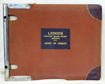
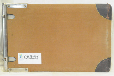
ledger, late 1950's - 1970's
... roads in Victoria between 1913 and 1983. It was succeeded... roads in Victoria between 1913 and 1983. It was succeeded ...This ledger was used by the Shire of Orbost in the late 1950's - 1970's.The item was donated to Orbost & District Historical society from P.R.O.V. as a Place of Deposit (POD) item for safe keeping by a local history group or museum. The shire covered an area of 9,347 square kilometres and existed from 1892 until 1994 when it became part of the East Gippsland Shire Council. Orbost was at first included in the Bairnsdale Shire from 1882 and was later part of the Tambo Shire. Because of travelling distances the Croajingalong Shire was created in 1892 (name changed to Orbost Shire 17.2.1893 with James Cameron as the first Shire President. In 1994 it amalgamated to become part of East Gippsland Shire Council. The Country Roads Board was the government authority for the construction and maintenance of main roads in Victoria between 1913 and 1983. It was succeeded by the Road Construction authority on 1 July 1983 and later merged with the Road Traffic Authority on July 1 1989 to form the Roads Corporation. James Cameron, an Orbost farming pioneer and Member of the Legislative Assembly, fathered the Country Roads Board This item is a hand-written record of Orbost Shire Council accounts. It pre- dates computer records. The Shire of Orbost local council no longer exists having been absorbed by the East Gippsland Shire Council.A black ledger with wooden covers. It contains hand-written records of transactions between Orbost Shire Council and the Country Roads Board.bottom left corner - Orbost in black on a white East Gippsland Shire logoledger accounts shire-of-orbost country-roads-board -
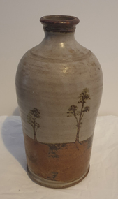 Ballarat Heritage Services
Photograph, Ceramic Bottle by Maldon Pottery
... - ) on Barringhup Road, Maldon, Victoria. Tom Metcalf and Graham Masters... Masters (1950- ) on Barringhup Road, Maldon, Victoria. Tom Metcalf ...Maldon Pottery was established in 1973 by Neville Wilson (1946-1996), Tom Metcalf (1948- ) and Graham Masters (1950- ) on Barringhup Road, Maldon, Victoria. Tom Metcalf and Graham Masters Masters graduated from Bendigo College of Advanced Education all Bendigo graduates. Wilson ) He was a skilled drawer and did all the brushwork. Metcalf (1948- ) graduated in 1968, did two years' work experience at Non-porite in Melbourne, then worked as a thrower and decorator at Bendigo Pottery from 1971-73. He is T.M. on Epsom ware. Masters (1950- ) graduated in 1973 and established the Enterprise Pottery at Myers Flat with Morris Hesse in 1974, so must have joined the partnership later than the others. He left in 1984 to set up his own Sweenies Creek Pottery. Metcalf left in the late 1980s, leaving Wilson to operate the pottery by himself until his death in 1996. As well as using the Maldon Pottery stamp, Wilson signed some of his work with his name or an impressed 'N'. Photograph of a hand thrown ceramic bottle, with glaze design depicting an Australian landscape in the 'continuous trees' pattern.maldon pottery, ceramics, australian studio pottery -
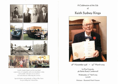 Melbourne Tram Museum
Document - Programme, Le Pine Funerals, "In Memory of Keith Sydney Kings", Apr. 2016
... on the corner of Burke Road and Victoria St Camberwell. .4 - Added 6... held on 10/4/2018 at le Pine on the corner of Burke Road ....1 - Four page - folded A4, heavy card, printed in full colour, Memorial Order of Service for Keith Sydney Kings, featuring a number of photos of Keith. Inside is the Order of Service. NOTE: The date of his birth should have been 12 November 1928. .2 - five A4 sheets, stapled titled "In Memory of Keith Sydney Kings" written by Len Millar for the service. Details Keith's tramway work. .3 - Keith's funeral car was followed by Federal Bus supplied by Driver Bus Lines which Keith and Charles Craig restored. Service held on 10/4/2018 at le Pine on the corner of Burke Road and Victoria St Camberwell. .4 - Added 6/5/2019 - Graeme Rodwell's Eulogy received by email as a word document 4/5/2019. Heading added, font changed to 12 point and page numbers added and saved as a pdf file - see image .5 - AV file - mp4 file of the service - see Reg Item 3458 in AV Files.trams, tramways, funeral, keith kings, buses -
Port Melbourne Historical & Preservation Society
Book, Ministry of Planning & Environment, South Melbourne's Heritage, Dec 1988
... on Kerferd road pier in 1890s. Victoria Hotel in background. Book... and children on Kerferd road pier in 1890s. Victoria Hotel ...Based on "City of South Melbourne Urban Conservation Study". Covers 1930s - 1960s.Paperback, illustrated guide to the history and development of South Melbourne "South Melbourne's Heritage" A4 sized book with coloured cover and blurred style picture of two women and children on Kerferd road pier in 1890s. Victoria Hotel in background. Book contains small black and white photos of buildings with descriptionsemerald hill, town planning, heritage, city of south melbourne -
 Orbost & District Historical Society
ledger, 1950's -1960's
... for the construction and maintenance of main roads in Victoria between 1913... for the construction and maintenance of main roads in Victoria between 1913 ...This ledger was used bt the Shire of Orbost local government to record Country Roads Board accounts 1950's and 1960's. The item was donated to Orbost & District Historical society from P.R.O.V. as a Place of Deposit (POD) item for safe keeping by a local history group or museum. The shire covered an area of 9,347 square kilometres and existed from 1892 until 1994 when it became part of the East Gippsland Shire Council. Orbost was at first included in the Bairnsdale Shire from 1882 and was later part of the Tambo Shire. Because of travelling distances the Croajingalong Shire was created in 1892 (name changed to Orbost Shire 17.2.1893 with James Cameron as the first Shire President. In 1994 it amalgamated to become part of East Gippsland Shire Council. The Country Roads Board was the government authority for the construction and maintenance of main roads in Victoria between 1913 and 1983. It was succeeded by the Road Construction authority on 1 July 1983 and later merged with the Road Traffic Authority on July 1 1989 to form the Roads Corporation. James Cameron, an Orbost farming pioneer and Member of the Legislative Assembly, fathered the Country Roads Board. This ledger is a hand-written record of accounts for the Orbost Shire local council. It pre-dates computer records. The Orbost Shire Council no longer exists having been absorbed into the East Gippsland Shire Council.A heavy brown coloured ledger with covered wooden covers. it has steel metal binding. Inside are strips of paper marking pages. It contains blue ink hand-written records of monies in/out (?) to Shire of Orbost Council. On the front cover inside a black rectangle in gold print is " LEDGER COUNTRY ROADS BOARD ACCOUNT ORBOST". It is an "Emu Binder".ledger orbost-shire accounts country-roads-board -
 Orbost & District Historical Society
ledger, 1950's ; 1960's
... for the construction and maintenance of main roads in Victoria between 1913... for the construction and maintenance of main roads in Victoria between 1913 ...This ledger was used by the Shire of Orbost to record transactions with the Country Roads board in 1950's and 1960's. The item was donated to Orbost & District Historical society from P.R.O.V. as a Place of Deposit (POD) item for safe keeping by a local history group or museum. The shire covered an area of 9,347 square kilometres and existed from 1892 until 1994 when it became part of the East Gippsland Shire Council. Orbost was at first included in the Bairnsdale Shire from 1882 and was later part of the Tambo Shire. Because of travelling distances the Croajingalong Shire was created in 1892 (name changed to Orbost Shire 17.2.1893 with James Cameron as the first Shire President. In 1994 it amalgamated to become part of East Gippsland Shire Council. The Country Roads Board was the government authority for the construction and maintenance of main roads in Victoria between 1913 and 1983. It was succeeded by the Road Construction authority on 1 July 1983 and later merged with the Road Traffic Authority on July 1 1989 to form the Roads Corporation. James Cameron, an Orbost farming pioneer and Member of the Legislative Assembly, fathered the Country Roads Board. This item is a hand-written record of accounts of the Orbost Shire local Government. It pre-dates computer records,The Shire of Orbost Council no longer exists having been absorbed into th East Gippsland Shire council.A heavy brown coloured ledger with steel bindings. Covers are probably wooden. It contains hand-written records of transactions the Country Roads Board. -
 Lakes Entrance Historical Society
Photograph - Historic House, 2000
... . Gable decoration above front window. Situated in Byrnes Road...Relocated from 14 Hunter Street, Lakes Entrance, Victoria ...Relocated from 14 Hunter Street, Lakes Entrance, Victoria, when owners had new home built.Colour photograph of a weatherboard dwelling with corrugated iron, hipped and gabled roof. Vernada across half front. Gable decoration above front window. Situated in Byrnes Road, Toorloo Arm, Lakes Entrance, Victoria.houses, fences, heritage study -
 Bendigo Historical Society Inc.
Newspaper - JENNY FOLEY COLLECTION: HARD YAKKA
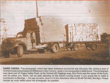
... Valley Road, at the Victoria Hill Diggings area. Eric Finch... was taken just off Happy Valley Road, at the Victoria Hill Diggings ...Bendigo Advertiser "The way we were" from Saturday, January 29, 2005. Hard yakka: this photograph, which was taken sometime around the late 40s early 50s, shows a load of finished boxes being loaded at Williamson's box factory, ready to be transported to Melbourne. the photograph was taken just off Happy Valley Road, at the Victoria Hill Diggings area. Eric Finch was the owner of the truck and his eldest son, Kevin, can be seen standing on the truck's running board. The clip is in a folder.newspaper, bendigo advertiser, the way we were -
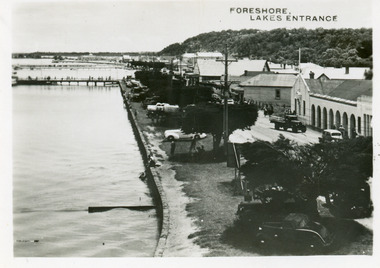 Lakes Entrance Historical Society
Postcard - Foreshore Lakes Entrance, 1945c
... between road and lake. Lakes Entrance Victoria... between road and lake. Lakes Entrance Victoria Postcard Foreshore ...From a wallet of miniature postcards published by H D Bulmer for sale as tourist souvenirs.Black and white small format postcard of the foreshore, showing jetties at the boat harbour opposite the Post Office, truck parked in front of Central Hotel, cars parked on the verge between road and lake. Lakes Entrance Victoriatownship, waterfront, transport -
 Ringwood and District Historical Society
Map - Plans of Subdivision, Part of Crown Allotments 35 & 39, Parish of Warrandyte
... in Kalinda Road and Grayling Crescent, Ringwood, Victoria. (Undated... in Kalinda Road and Grayling Crescent, Ringwood, Victoria. (Undated ...Survey maps of stages 1, 2 & 3 of residential allotments in Kalinda Road and Grayling Crescent, Ringwood, Victoria. (Undated, circa 1960). Some allotments are marked with real estate information and prices in pre decimal £s.Adshead & McGuire, Land Surveyors L.S. M.I.S. (Aust), 268 Albert Street East Melbourne (Ref 118/2a b &c) Tel 41-6960. The land colored blue is set apart for drainage & sewerage purposes. Reference Marks (R.M's) are Gal Iron Pipes 12"x1". Levels shown are to M.M.B.W. Datum. The land shown hatched is subject to innundation. -
 Whitehorse Historical Society Inc.
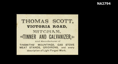
Functional object - Business Card
... the producer of tiles we have in the exhibition.|Victoria Road is now...Thomas Scott|Victoria Road, Mitcham.|Tinnner an Galvanizer....|Victoria Road is now Rooks Road. documents cards Thomas Scott ...Thomas Scott was a descendant of Sir. Walter Scott (uncle) and the grandfather of Chrissie Ottenback, mother of Mrs Ottenback the producer of tiles we have in the exhibition.|Victoria Road is now Rooks Road.White business card printed in black.Thomas Scott|Victoria Road, Mitcham.|Tinnner an Galvanizer and Manufacturer of Tinsmith's Mountings.|Meat Stands, Gridirons, and every description of light forge work.documents, cards -
 Phillip Island and District Historical Society Inc.
Financial record, Credit account from J.Kennon & Sons for N. L. Smith, Rhyll, 23 March 1914
... , Richmond and a leather warehouse in Bridge Road. [ Source -Heritage... Street, Richmond and a leather warehouse in Bridge Road. [ Source ...J.Kennon & Sons were known particularly for their use of the chrome tanning process. They were also buyers and exporters of Australian skins and wool.The firm had tanning works,, established in 1863, offices and stores in the vicinity of River Street, Richmond and a leather warehouse in Bridge Road. [ Source -Heritage Victoria https://www.google.com/url?sa=t&rct=j&q=&esrc=s&source=web&cd=&cad=rja&uact=8&ved=2ahUKEwiI7OnmofT_AhUia2wGHXNGCaUQFnoECBQQAQ&url=http%3A%2F%2Fimages.heritage.vic.gov.au%2Fattachment%2F24257&usg=AOvVaw0ER8QGZ-3eW4PAg0VM909h&opi=89978449]HistoricalCream coloured account with details eg product and amount in black ink. Includes a separate piece of paper attached to page, with a recipe for vermin destroyer typed in red ink.Credit account of N. L. Smith, Rhyll, Phillip Island. One bag of Rabbit Weevily. March 23, 1914 J. Kennon & Sons River Street, Richmondn.l.smith rhyll, j.kennon and sons, rabbit poison, account, vermin -
 Eltham District Historical Society Inc
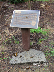
Photograph, Liz Pidgeon, Monument containing a time capsule in celebration of Victoria's 150th Anniversary and marking the location of the original centre of Eltham township, 21 June 2017, 21 June 2017
... at the comer of Pitt Street and Main Road to commemorate Victoria's...Main Road, Eltham, Victoria, Australia... at the comer of Pitt Street and Main Road to commemorate Victoria's ...A walk around Little Eltham, 21 June 2017 Newsletter No. 175 July 2007 FORTY YEARS IN HISTORY The Society has been involved with a number of one off historical projects that have lasting outcomes. Perhaps the most significant is the monument and time capsule installed at the Eltham Community Centre site at the comer of Pitt Street and Main Road to commemorate Victoria's 150th anniversary. The monument based on a blacksmith's tyring plate was designed by artist Joh Ebeli. Beneath it is a time capsule containing items from 1985 and donated by Graham Beyer. It is to be opened in 2035.Born Digitalmain road, time capsule, monuments -
 Eltham District Historical Society Inc
Photograph, Liz Pidgeon, Monument containing a time capsule in celebration of Victoria's 150th Anniversary and marking the location of the original centre of Eltham township, 21 June 2017, 21 June 2017
... at the comer of Pitt Street and Main Road to commemorate Victoria's...Main Road, Eltham, Victoria, Australia... at the comer of Pitt Street and Main Road to commemorate Victoria's ...A walk around Little Eltham, 21 June 2017 Newsletter No. 175 July 2007 FORTY YEARS IN HISTORY The Society has been involved with a number of one off historical projects that have lasting outcomes. Perhaps the most significant is the monument and time capsule installed at the Eltham Community Centre site at the comer of Pitt Street and Main Road to commemorate Victoria's 150th anniversary. The monument based on a blacksmith's tyring plate was designed by artist Joh Ebeli. Beneath it is a time capsule containing items from 1985 and donated by Graham Beyer. It is to be opened in 2035.Born Digitalmain road, time capsule, monuments -
 Surrey Hills Historical Society Collection
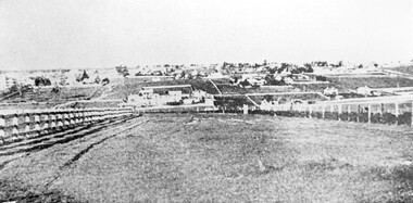
Photograph, Looking towards Box Hill from the site of the Surrey Hills Golf Club, 1902, 1902
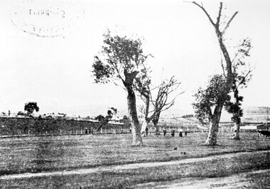
... Road and down Victoria Crescent to where Box Hill TAFE is now... Trafalgar Street, Mont Albert to Whitehorse Road and down Victoria ...Reproduced by permission of Mr John Arnold from his book: "The Riversdale Golf Club - a history, 1892-1977." Copyright to book: Riversdale Golf Club. Surrey Hills Golf Club operated from 1892-1908 then moved and became Riversdale Golf Club. The game was played across paddocks from Trafalgar Street, Mont Albert to Whitehorse Road and down Victoria Crescent to where Box Hill TAFE is now located in Elgar Road. There were problems with cows eating the tee flags! The clubhouse still exists as 30 Trafalgar Street.Black and white photo with a large grassy paddock in the foreground. From the bottom left and right post-and-rail fences converge on a group of large industrial buildings in the centre middle distance. In the background are paddocks and buildings."Top: Looking towards Box Hill from the links in 1902. The old Box Hill Gas Works is in the centre of the picture."sports grounds, surrey hills golf club, riversdale golf club, box hill gas works, gasworks, public utilities, gas -
 Surrey Hills Historical Society Collection
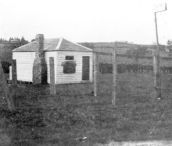
Photograph, The gate-keeper's shed, Surrey Hills Golf Club
... Road and down Victoria Crescent to where Box Hill TAFE is now... Trafalgar Street, Mont Albert to Whitehorse Road and down Victoria ...Reproduced by permission of Mr John Arnold from his book: "The Riversdale Golf Club - a history, 1892-1977." Copyright to book: Riversdale Golf Club. Surrey Hills Golf Club operated from 1892-1908 then moved and became Riversdale Golf Club. The game was played across paddocks from Trafalgar Street, Mont Albert to Whitehorse Road and down Victoria Crescent to where Box Hill TAFE is now located in Elgar Road. There were problems with cows eating the tee flags! The clubhouse still exists as 30 Trafalgar Street.Apart from it association with the Surrey Hills Golf Club which is long gone, this image documents the landscape of pre-urban Surrey Hills.Black and white photo of a rectangular timber building with a slate hip roof and brick chimney on the LHS. The one visible window appears to be boarded up and has a door to its right. The building is fenced by posts and wire. A (?) street sign bearing the letters FLINT is at the right of the picture."The gate-keeper's shed was used as a clubhouse from 1895-1900."sports grounds, surrey hills golf club, riversdale golf club, timber building, john arnold -
 Surrey Hills Historical Society Collection
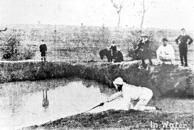
Photograph, Surrey Hills Golf Club water hazard, 1895, 1895
... Road and down Victoria Crescent to where Box Hill TAFE is now... Trafalgar Street, Mont Albert to Whitehorse Road and down Victoria ...Reproduced by permission of Mr John Arnold from his book: "The Riversdale Golf Club - a history, 1892-1977." Copyright to book: Riversdale Golf Club. Surrey Hills Golf Club operated from 1892-1908 then moved and became Riversdale Golf Club. The game was played across paddocks from Trafalgar Street, Mont Albert to Whitehorse Road and down Victoria Crescent to where Box Hill TAFE is now located in Elgar Road. There were problems with cows eating the tee flags! The clubhouse still exists as 30 Trafalgar Street.Apart from its association in documenting the Surrey Hills Golf Club which has long disappeared, this image documents the landscape in the pre-urban era.Black and white photo of a scene at Surrey Hills Golf Club. There is a water hazard in the foreground with a lady on her knees trying to retrieve a ball from the water's edge. Three lads, one on a horse, are watching, as are 3 males to the right."In water" in the bottom right of the photo. Caption: "Captain Fred Andrew watches his partner's misfortunes during a game at Surrey Hills in 1895."sports grounds, surrey hills golf club, riversdale golf club -
 Surrey Hills Historical Society Collection
Photograph, Surrey Hills Golf Club - looking towards Doncaster, 1902, 1902
... Road and down Victoria Crescent to where Box Hill TAFE is now... Trafalgar Street, Mont Albert to Whitehorse Road and down Victoria ...Reproduced by permission of Mr John Arnold from his book: "The Riversdale Golf Club - a history, 1892-1977." Copyright to book: Riversdale Golf Club. Surrey Hills Golf Club operated from 1892-1908 then moved and became Riversdale Golf Club. The game was played across paddocks from Trafalgar Street, Mont Albert to Whitehorse Road and down Victoria Crescent to where Box Hill TAFE is now located in Elgar Road. There were problems with cows eating the tee flags! The clubhouse still exists as 30 Trafalgar Street.This image is important for reference to the landscape and vegetation prior to urbanisation.Black and white photo in the foreground of which is a path running diagonally from left to right. Behind are 5 mature trees whose condition is not vigourous (showing signs of die-back). Several figures are beneath the trees, behind which is a post-and-wire fence, paddocks and distant houses. There is the shadow of a stamp in the top LH corner, suggestive of this having been copied from an earlier image.Caption: "Top: Looking towards Doncaster from the links in 1902."sports grounds, surrey hills golf club, riversdale golf club, john arnold -
 Surrey Hills Historical Society Collection
Photograph, Corner of Braemar and Melrose Streets, Box Hill North
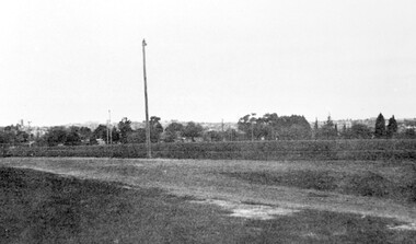
... Road and down Victoria Crescent to where Box Hill TAFE is now... Trafalgar Street, Mont Albert to Whitehorse Road and down Victoria ...Reproduced by permission of Mr John Arnold from his book: "The Riversdale Golf Club - a history, 1892-1977." Copyright to book: Riversdale Golf Club. Surrey Hills Golf Club operated from 1892-1908 then moved and became Riversdale Golf Club. The game was played across paddocks from Trafalgar Street, Mont Albert to Whitehorse Road and down Victoria Crescent to where Box Hill TAFE is now located in Elgar Road. There were problems with cows eating the tee flags! The clubhouse still exists as 30 Trafalgar Street.Black and white panoramic photo taken from the corner of Braemar and Melrose Streets, Box Hill North. There is a large area of ground in the front. A fence and hedge traverse the photo in the middle distance in front of which is a tall light pole. Behind the hedge mature trees and houses can be made out.Caption: "Bottom: The same view today taken from the corner of Braemar and Melrose Streets, Box Hill North, or, from the position of the threesome to the left in the above photograph." + in grey lead pencil in Jocelyn Hall's hand (No 290)sports grounds, surrey hills golf club, riversdale golf club, melrose street, braemar street, surrey hills, john arnold -
 Melbourne Tram Museum
Book - Cable tram records - book 1 of 4, Alf Twentyman, c1940 to 1985
... stock, sketch of St Kilda Road, Victoria Parade - Brunswick St... stock, sketch of St Kilda Road, Victoria Parade - Brunswick St ...First of four documents compiled by Alf Twentyman about the history of Melbourne cable trams. On the inside of the rear cover has a table of contents - see image 1. Includes sketches of San Francisco grips, sketches of destination signs on the cable cars, Auburn Road and Kew horse tram timetables rolling stock, sketch of St Kilda Road, Victoria Parade - Brunswick St, listing of ropes and their life spans, tables of cars out for various depots, timetables, list of visitors to Northcote, new MMTB rolling stock listing.Demonstrates the recording and drawing work of Alf Twentyman and his notes.Exercise book - part ruled - part plain pages - 92 numbered pages + fawn coloured covers, centre stapled.tramways, cable trams, alf twentyman, history, track plans, records -
 Lakes Entrance Historical Society
Photograph - Historic House, 2000
... site in Williams Road. The entrance steps and stonework were... site in Williams Road. The entrance steps and stonework were ...This residence named 'Mourilyan' was built in 1892 beside Harbeck's Store, Lakes Entrance, as a family residence. It was altered and extended in 1927. In 1968 it was relocated to present site in Williams Road. The entrance steps and stonework were constructed by Rev A E Clark. Internal renovations during 1990's. Continually occupied by Harbeck family and descendents. Also a colour photograph of the front entrance of same dwelling in new location at Williams Road, Lakes Entrance. Also one colour photograph of the front entrance of same dwelling in new location at Williams Road Lakes Entrance VictoriaBlack and white photograph of a fibro dwelling on Esplanade, beside Harbecks's Store. Lakes Entrance Victoriahouses, heritage study -
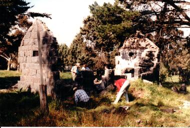 Hume City Civic Collection
Photograph, c 1993
... ) and Calder Highway (Victoria St/Mt. Alexander Road). It was part...) and Calder Highway (Victoria St/Mt. Alexander Road). It was part ...Aitkens Gap Police Lock up was originally constructed at The Gap which was south of the junction of Gap Road (Sunbury Road) and Calder Highway (Victoria St/Mt. Alexander Road). It was part of a police complex which was a changeover station for the gaol escort. The goal was relocated and rebuilt in the police station grounds in Sunbury in 1993.A coloured photograph of five men working on the removal of Aitkens Gap Gaol from its original site. Two end walls of the gaol are standing and the work is being done on the front and back of the building. Conifers and cypress trees are growing around the site.peter free, aitkens gap gaol, police historical association, sunbury police station, george evans collection