Showing 4273 items
matching street plan
-
 Glen Eira Historical Society
Letter - St Aloysius Church, Caulfield
A series of correspondence dated between 21/08/1985 to 10/11/1988 regarding the Historic Buildings Council adding St Aloysius Church on Balaclava Road, Caulfield to the Historic Buildings Register. Four of the letters are between the Historic Buildings Council, the Caulfield Historical Society and the City of Caulfield. Copies of the replies by the Historical society (as indicated by handwritten notes in the letters) are not included in the file. A fifth letter dated 14/09/1989, addressed to Reverend Father John Fraser, Parish Priest at St Aloysius, advises him of the inclusion of St Aloysius on the National Trust Register due to its historic significance. Also included is a photocopy of the Caulfield Conservation study of St Aloysius, dated February 1994, by Andrew Ward. This study details the architectural features and historic significance of the church, recommending planning scheme control. It includes a front view photograph, which is not clear, and references.caulfield, catherine street, tonkin ray, st aloysius church, grey karen, fraser john rev. fr., catholic church, wills cathie, davies stephen, balaclava road, ballantyne r mr, ward andrew, city of caulfield, head stephen, moriarty bartholemew, de carle henry, mannix archbishop, caulfield historical society, caulfield conservation study, foundation stones, town halls, local officials and employees, registers, committees and inquiries, gothie (revival) architecture, architectural features. -
Glen Eira Historical Society
Document - Helenslea, Shelford CEGGS
Three copies of a photocopied fold out brochure for the auction of Helenslea mansion and stables on 25/03/1916 in association with the sale of the adjoining allotments of the Helenslea Estate. The brochure includes a map of the Helenslea Estate, a photograph of the view from Helenslea Mansion, an illustration of the exterior of the Mansion and a detailed floor plan of the Mansion and stables.helenslea mansion, helenslea estate plan, glen eira road, hood crescent, merton street, stables, hawthorn road, orrong road, morrice street, helenslea road, st kilda east, auctions, st mary’s church, caulfield north, land subdivision, land brochures, residential development -
Glen Eira Historical Society
Book - Hillcrest Estate Draft Heritage Guidelines July 2000
2 items about Hillcrest Estate and heritage: 1/A 20 page report giving draft heritage guidelines by the City of Glen Eira for properties within the Hillcrest Estate Heritage Area of Caulfield South, including Hillcrest Avenue numbers 1 and 3-12 and Marara Road numbers 27 and 28. The Heritage Area has been assessed as noteworthy as 'the first housing estate developed by the AV Jennings Construction Co., later known as Jennings Group Limited.' Developed during the Depression years of the early 1930s, it is considered an 'unusually intact example of an interwar garden estate' and is also considered noteworthy for its aesthetic values. The Report describes typical features for two house forms typical of the area: the single-storey villa with decorative porch and the single storey villa with decorative verandah. It gives guidelines on the types of changes which can be made to houses within the Heritage Area. Included are photographs of typical houses and design features, maps, and diagrams showing acceptable zones for additions, amongst other Sections (eg. Key design checklist). 2/A three page photocopy taken from Andrew Ward's Heritage Study for The Hillcrest Estate Historic Area.hillcrest estate, glen eira heritage management plan, glen eira planning scheme, glen eira city council, hillcrest estate heritage area, hillcrest avenue, merri street, marara road, eumerella street, av jennings construction co, jennings group limited, caulfield south, jennings albert, brick houses, architectural styles, architectural features, housing estates, garden estate, heritage studies, glen eira city council, city of glen eira, draft heritage guidelines july 2000, glen huntly, vines william, gurney edward, eumeralla street, 'karkill', house names, cropmpton court, booran road, estate agents -
Glen Eira Historical Society
Document - Hopetoun, Hopetoun Street, 2, Elsternwick
Photocopy of Caulfield Conservation Study for this address, conducted in September 1994. It outlines a description of the Italianate villa architectural aspects of Hopetoun Private Hospital, the history of the owners of the property and the recommendations for inclusion on the National Estate Register and for the planning Scheme control. By Andrew Ward. Includes two photocopied photographs of the exterior of the exterior.italianate style, hopetoun, melrose, hospitals, verandahs, mansions, towers, architectural features, architectural styles, webb charles, architects, glenhuntly road, elsternwick, cutts joseph, korong street, king street, hopetoun street, geoghegan hanbury, webb alfred, kopat pty ltd, webb florence mabel, o’brien annie, reeve charles, haines edith, thomas albert, ward andrew, hopetoun private hospital -
Glen Eira Historical Society
Document - Grange Road, Corner of Neerim Road, Glen Huntly
This file contains 3 items about the construction of this property: 1/An original typed building agreement dated 25/09/1936 between the contractor Ernest F Barnard and the purchaser Mr & Mrs Hulbert Gorrie 2/The original blue print plan of a brick villa at the corner of Grange & Neerim Road for Mr & Mrs Hulbert Gorrie. Dated 25/09/1936 3/The original specification for the dwelling on the corner of Grange & Neerim Road, Glen Huntly for Mrs Gertrude Gorrie & Mr Hulbert Hopetoun Gorrie by builder Ernest F Barnardbarnard ernest f, gorrie gertrude, gorrie hulbert hopetoun, hobart john bertram, coorigil road, carnegie, holloway st, ormond, chemists, parish of prahran, caulfield county of bourke, building agreement, brick houses, builders, plans, architectural drawings, grange road, glen huntly, holloway street, ormond, emma street, grange road, neerim road, barnard ernest f, gorrie h.h, gorrie gertrude, gorrie hulbert h, legal documents -
Glen Eira Historical Society
Document - Classic Retirement Village, Brighton
Four documents about the history of this site pre Classic Retirement Village: 1/A copy of a description of the sale process of the Gascor site, cnr Nepean Highway and Thomas Street, to Becton Corporation in 1997 And 1998. Printed on 31/07/2010 from the Victorian Auditor General’s Department website with aerial photograph 2/A copy of page one of the Gleneira Planning Scheme dated 19/01/2006 which mentions the Gascor site. 3/Research note by Andrew Frederick dated August 2010 listing occupiers of the site in the 1960 and the 1970 Sands and Mc Dougall Directories. 4/Research note by Claire Barton dated May 2010 containing Ian Swan’s recollections of working at Daylesford Worsted Woollen, occupier of the site, in the 1960s.thomas street, brewer road, bentleigh, gascor, becton corporation pty ltd, virginia park, gas and fuel, hughesdale dairy, east boundary road, moorabin, east bentleigh, hooblerstone, clairmont avenue, glen eira, daylesford centenary woollen and worsted mills pty ltd., nepean highway, f and j industries australia plastic and rubber division., swan ian, korman stanley, mills, wool industry, weaving mills, textile factories, textile manufacturing, manufacturing industry -
 Glen Eira Historical Society
Photograph - NETTALIE
Various documents about and photographs of Nettalie or Netley House or The Nest on Balaclava Road Caulfield now part of Melbourne Grammar School: 1/The first is an article undated and unattributed accessed from Beresford.org on 14/07/2006 detailing with bibliography the history of Netley House including the owners especially the Shaw family. 2/There are several separately colour-printed photographs of the front facade of Nettalie most undated and unattributed, and one family portrait of the Shaw family circa 1863. All were also accessed from Beresford.org on 14/07/2006. 3/One black and white photograph is inscribed '73 Balaclava Rd Caulfield 3/9/72 Neg 16A'. 4/Two copies of a plan of Nettalie next to The Curragh and Harleston, also in the article and likely accessed from same source on same date. 5/A copy of Dr Cameron’s letter to Herbert Shaw dated 24/05/1949. 6/One copy of a letter from Herbert Shaw to Dr William Cameron dated 25/05/1949. 7/A plan of Melbourne Grammar School with each building dated to when it was built including Netley House in 1863.shaw herbert, shaw alfred henry, shaw arthur, shaw amelia, shaw lavinia, forsyth william, blundell mary, fosbery john, bakewell john, hailes george b, blundell miss, stephen george sir, billings richard, ware martha, desailly alfred, cameron william dr, cameron j mrs, nettalie, the nest, netley house, house names, caulfield north, balaclava road, grimwade house, orrong road, harleston, caulfield road district, st kilda east, the curragh, shelford, helenslea, sylliot hall, labassa, o’loughlin street, ormond, hotham street, melbourne grammar school, caulfield conservation study, mansions, teachers, schools, independent schools, hardware stores, business people, lawyers, businesses, brick houses, outbuildings, architectural styles, classrooms, bunya bunya pine trees, trees, orchards, land subdivisions, land sales, doctors -
Glen Eira Historical Society
Plan - Nettalie
An A4 photocopy of the 'Plan of the Caulfield Road District' dated 1867. This plan shows the location of the properties owned by A Shaw and Blundell on Balaclava and Orrong Roads where Nettalie is situated. The plan includes all the landowners listed where their property was, the street names and other landmarks of 1867 including railways, hotels and reserves.caulfield, caulfield north, elsternwick, st kilda east, parish of prahran, parish of moorabbin, caulfield road district, melbourne and brighton railway, rosstown railway, elsternwick railway station, caulfield railway station, rosstown railway station, murrumbeena railway station, baptist church, paddy’s swamp reserve, cemetery reserve, leman swamp reserve, caulfield racecourse reserve, brighton cemetery, the vine caulfield hotel, the tam o’shanter hotel, melbourne hunt hotel, royal hotel, hotham street, horne street, nepean highway, north road, orrong road, dandenong road, princes highway, kooyong road, alma road, inkerman road, balaclava road, glen eira road, glen huntly road, hawthorn road, cemetery road, bambra road, redan road, kambrook road, neerim road, booran road, racecourse road, grange road, koornang road, murrumbeena road, crosbie road, kangaroo road, poath road, ford w, lempriere, cople j, riddell j c, manifold j, testar t, billing r h, semple, blundell, shaw a, butchart g, stephen j w, stephen g sir, hart j, duncan g, blackie r, stephen f, mccombie t, woollaston h, higgins j, lloyd j c, daish j, mcleod j, hughes d, wilson a, jamieson g, webb g h, renwick s, pennington h, dunn j, kirkpatrick w, ricketson w, toad a, sayce j, watts t, widgery, store, guess j, anketell j, clack j, sissen w, clayton g, dickson d, bevan j, hart t, anderson j, hart mrs, webb h, masters s, waghorn j, hemming c, hiam c, farquhar w, newing t, payne t, cooper r, snipe s, chambers j, forster w, summers r, harriman b, warrick, o’connell, long j, peck r, cochrane c, murray ross w, evans c, kennedy j, maclean n, forster, lyall w, dean j, newton h, looker w, baker c, johnston, crosbie j, kerr, jones, parr, nelson c, montgomery l, parsons w, james j c, sibon c, smith sydney w, plans, maps, land subdivisions, land use, settlements, roads and streets, hotels, churches, police stations, post offices, land surveys, railway stations, railways, schoolhouses, commerce, clergy residences, official buildings, local government, road districts -
Glen Eira Historical Society
Plan - Monkleigh, Gladstone Parade, 12, Elsternwick
... Trevelyan Street Mansions Plan Monkleigh, Gladstone Parade, 12 ...This file contains three items, the first a typed evaluation of Monkleigh to J.C. Ellis, Esq. from A.E. Lillie dated 02/12/1907. Also included is an original memo to J.C. Ellis, Esq. from A.E.Lillie dated 14/05/1908 with description and condition of house. Also included is a plan with outline dimensions of Monkleigh Land Unattributed, undated, handwritten note that Colin Wimberley lived at Monkleigh according to Sands and McDougall directory 1911.glenhuntly road, elsternwick, ellis j. c., lillie a.e., caulfield, gladstone parade, architectural features, monkleigh, trevelyan street, mansions -
Glen Eira Historical Society
Document - Nithsdale
Photocopied copy of flyer for forthcoming subdivision of Caulfield Heights Estate on 27/10/1888. Includes locality plan and subdivisions. Photocopied copy of flyer for forthcoming sale of properties and mansion, Nithsdale on 18/09/1889, includes map of area.carriages and coaches, caulfield heights estate, caulfield north, maxwell grove, kambrook road, neerim road, blake street, bambra road, racecourse road, auctioneers, station street, glen eira road, paynes j., mansion, beauchamp brothers -
Glen Eira Historical Society
Plan - Nithsdale
This file contains one item about this property: Three postcard sized photographs of a flyer for the subdivision sale of the area incorporating this property for Saturday 22/11/1924. The flyer shows photographs (black and white) and plan of the area around 'Nithsdale'.nithsdale', caulfield north, hudson street, bambra road, kambrook road, centre way, oak court, caulfield railway station, balaclava road, glenhuntly road, caulfield racecourse -
Glen Eira Historical Society
Plan - Oswald Street, 6/17, Elsternwick
... . Oswald Street Elsternwick Home Units Verandahs Plans Brick Houses ...Copy of letter to Mr. and Mrs. J.M. Cunningham from sworn valuator W.V. Scott regarding detailed valuation of 6/17 Oswald Street Gardenvale dated 27 September 1977. Handwritten notes and plan recording the measurements of all the rooms. A cover copy letter to Mr. and Mrs. J.M. Cunningham from W.V. Scott 27 September 1977 with handwritten notes.cunningham j.m., oswald street, elsternwick, home units, verandahs, plans, brick houses, scott. w.v., bay windows, valuation -
Glen Eira Historical Society
Plan - Centre Road, 734, Bentleigh East
A one page typed letter, dated 30/09/1970 addressed to S P Simmonds Estate Agency from William Lasica and Co Solicitors requesting a valuation of the property at 734 Centre Road, Bentleigh East. The file also includes four pages of handwritten, undated and unattributed working notes with property description, calculations and a rough plan (96mm x 94mm) of the ground floor of the building for the valuation. Also included in the file is a two page duplicate copy of a typed letter, dated 08/10/1970 from W V Scott to William and Lasica Co Solicitors containing the valuation of the relevant property and rental details. The file also includes a one page photocopy of a handwritten document dated 15/11/1967. It gives details of a previous mortgage. The file also includes a photocopy, dated 26/09/1970, of the Certificate of Title of Lot 6 of Subdivision No 60044 Parish of Moorabbin. It includes a plan of the property (139mm x 123mm).klauss anna sara, klauss edward, green william james, green margaret estelle, green william thomas, myers thomas lee, lombard joseph patrick, graham george kinnell, tobin thomas norman, mcintosh edward joseph, bentleigh east, east bentleigh, centre road, bentleigh station, omeo court, east boundary road, s p l constructions pty ltd, r k c nominees pty ltd, maryland street caulfield investors, flats, land values, land titles, rents, renting, \ -
Glen Eira Historical Society
Plan - Clarinda Street, 27, Caulfield South
... Sycamore Road South Caulfield Glenhuntly Road Plan Clarinda Street ...A one page typed letter from Plante and Henty Solicitors on behalf of the Executor of the will of the late Grace Ellen Gillespie, to W V Scott of S P Simmonds and Co, dated 04/03/1957, requesting valuation of 27 Clarinda Street, Caulfield South for Probate purposes. The letter is accompanied by the Certificate of Title for the property which includes a map (87mm x 67mm) of the property. It is also accompanied by a floor plan (300mm x 205mm) of the house. The file also includes a two page copy of correspondence from W V Scott to Plante and Henty, dated 22/03/1957, providing the valuation of 27 Clarinda Street. The file also includes three pages of handwritten working notes for the purposes of the valuation which provide dimensions and estimated value of the property.scott w v, gillespie grace ellen, clarinda street, solicitors, s p simmonds and co estate agents, property values, land values, plans, architectural features, land titles, certificates, caulfield south, prahran east, elsternwick county of bourke, sycamore road, south caulfield, glenhuntly road -
Glen Eira Historical Society
Document - Craigellachie
A documentary and physical investigation into the history and development of Craigellachie, located at 2B Lynedoch Avenue, St Kilda East, by Debra Lewis. Includes an examination of the house’s condition as at 2002, photocopies of photographs and plans of the house illustrating key architectural features and changes to the house. Includes a handwritten letter dated 08/02/2002 from Debra Lewis regarding the donation of the copy of her research paper.craigellachie, lynedoch avenue, st kilda east, lewis debra, gill j, lyall w, young william, smith w sydney, pearson william, orrong road, inkerman street, caulfield, italianate style, architectural styles, sawers john, mcculloch david, crawford minnie, crawford robert, thomson emma, thomson percy, elliot sibley c, saint pearl, roche james, yorston james, griffiths william, francis newton, francis marie, cocks norman, heisler geraldine, freeman julie, freeman richard, cast iron work, stained glass, bibliography, plans, architectural drawings, architectural features -
Glen Eira Historical Society
Book - Dalkeith
A 69 page bound history of the McConchie family who occupied Dalkeith. Mention is also made of the Lade family who had associations with the McConchie family and Dalkeith. The book includes numerous stories and memories concerning places, residents and locals from areas where the McConchie and Lade families holidayed and lived. The book also includes copies of marriage certificates of the family, family photographs, birth certificates, newspaper articles relating to the McConchie family, relevant correspondence, a hand drawn plan of the Dalkeith property, school records and some other relevant extracts. The file also includes a one page hand drawn family tree and one page of handwritten research notes.mcconchie william, dick agnes, elsternwick, dalkeith, kooyong road, caulfield, davis street, bootmakers, staniland grove, saddleries, glenhuntly road, orrong road, carre street, charles street, hopetoun street, mcconchie harry, mcconchie alan, mcconchie don, grocers, caulfield citizen band, st johns presbyterian church, hawthorn road, caulfield methodist church, crocket mr, mcconchie janet, mcconchie agnes, mcconchie annie, lade family, lade ruth, lade marjorie, mcconchie thomas, blacksmiths, murray street, weatherboard buildings, st mary’s, glen eira road, bands, hopetoun gardens, elsternwick station, hansom cabs, tin lizzie vans, postal services, brighton cemetery, cemeteries, grange road, ripponlea, mcconchie david, caulfield state school -
Glen Eira Historical Society
Article - Elizabeth Street, 30, Elsternwick, formerly Trengrove
A one page article from the Southern Cross newspaper, dated 09/12/1998, on page 12, for the auction of the mansion at 30 Elizabeth Street. The article includes a brief history of the existence of a 1908 property called "Trengrove", occupancy of the current house built for Mrs SJ Hannon after the demolition of "Trengrove" in 1937, mention of the Edna Walling-designed garden, a description of the property and the interior plan and three colour photographs (168mm x 121mm; 59mm x 78mm; 58mm x 73mm) taken by Maurice Grant-Drew.rippon lea estate, elizabeth street, elsternwick, sargood fredericl sir, bent thomas, hannon s j mrs, georgian revival style, gardens, architectural features, walling edna, flats, house names, talbot birner morley, trengrove, architectural styles, grant-drew maurice -
Glen Eira Historical Society
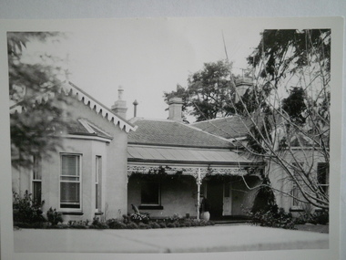
Article - Glenfern
Caulfield Conservation Study conducted by Andrew Ward in October 1994, outlining a description of the gothic revival architectural aspects of Glenfern. It includes the history of the owners and the forthcoming recommendations for planning scheme control. Includes three exterior photographs.inkerman road, glenfern, gothic revival architecture, gothic style, bakewell john, st kilda east, hotham street, mcdonnell francis, mansions, laing charles, watson thomas, du frayer agnes, boyd john, boyd lucy, hennessy m., architect, smith and johnson, danne mary, primary school, newington college, ostberg anders, inkerman street, ostberg sarah, mair agnes, glenfern college, ostberg amy, ostberg ebba, stables -
Glen Eira Historical Society
Plan - a'Beckett Street, 11, East St Kilda
... a’Beckett Street East St Kilda Flats Plans Garages Outbuildings ...A hand drawn site and floor plan of a building subdivided into 3 flats at 11 a'Beckett Street, East St Kilda; undated but prior to November 2010 by person unknowna’beckett street, east st kilda, flats, plans, garages, outbuildings, residential development -
Glen Eira Historical Society
Letter - Anselm, Glenferrie Street, 4, Caulfield North
Various detailed descriptions of the architectural features of Anselm. Includes a photocopy of the Caulfield Conservation Study report on Anselm by Andrew Ward, dated 02/1994, with a photo (152mm x 97mm). Also includes 3 pages of unattributed, undated, typed and handwritten research notes with detailed descriptions of the architectural features of Anselm. Also includes a photocopy of two hand-drawn room plans (100mm x 82mm; 81mm x 75mm), detailed hand-written descriptions of the rooms (3 pages) and a hand-drawn crest (41mm x 29mm), compiled by Mrs J O’Donnell in 1972. The file also includes a copy of the tile and inscription located at the base of the tower (41 mm x 56 mm). Also included is a copy of the letter, dated 31/10/2011, from the National Trust of Australia, regarding the classification upgrading of Anselm. Includes references.cohen samuel, haddon robert joseph, graham c. g., o’donnell j., ward andrew, anselm, caulfield north, glenferrie street, balaclava road, st. stephen’s presbyterian church caulfield, architectural features, architectural styles, attics, towers -
Glen Eira Historical Society
Document - Riddell Parade, 48, Elsternwick
Two items about this property: 1/A typed Research report on the history of the property at 48 Riddell Parade, Elsternwick, built in 1916/1917 on a subdivision of John Carre Riddell’s land. Prepared by Hilary Bullock and Rosalind Landells of the Brighton Historical Society, dated 14/08/1992. Includes a list of past owners and residents of the property. Their handwritten working notes, undated, are also included. 2/A plan of the subdivision of Riddell Estate from Sand Swamp and Heath (photocopy).cavers carre, riddell john carre, elsternwick, riddell parade, weedon james, walker alice o mrs, foley christina mrs, foley aileen c dr, 'carmel', house names, mcmillan archibald, mcmillan street, 'sand swamp and heath', carre street, gisborne street, landells rosalind, bullock hilary -
Glen Eira Historical Society
Letter - Bellecourt, Seymour Road, 85, Elsternwick
A typewritten letter to Mr Johnston from the National Trust Victoria, concerning the listing of Bellecourt by the Trust. The file also includes a print of the Victorian Heritage Database web page on Bellecourt with a black and white photograph (60mm x 45mm) of the house. Also included is a document giving additional details on Bellecourt with a black and white illustration (85mm x 130mm) of the house, source unknown though handwritten notes provide that it is a duplicate from the book Caulfield’s Building Heritagebellecourt, buildings, heritage studies, architectural features, history, johnston mr, hart trevor, town clerks, caulfield south, filbert street, beemery, glen eira road, kooyong road, seymour road, blanche street, kooyong estate, caulfield, caulfield north, langdon charles pettey, rosecraddock, rose craddock, tarqua, hengar, victorian style, seymour street, kooyong estate, beemery park extension, langdon h j, langdon montague, lirrewa, rennick samuel, the garrell, langdon family, victorian era, neringa, little gromer, little cromer, parson charles, moloney james, trezise alex, vassy albert, johnston mrs, solomon g, caulfield’s heritage , volume 1 city of caulfield, city of glen eira heritage management plan, ward andrew, belemery park, johnston archibald -
Glen Eira Historical Society
Plan - Brady Road, 10, Bentleigh East
... Wingate Street Plan Brady Road, 10, Bentleigh East ...A two page letter, dated 20/03/1973, from J M Smith and Emmerton Solicitors on behalf of Mrs J V Maxted to S P Simmons Estate Agent, requesting a sworn valuation of property at 10 Brady Road, Bentleigh East. The file also includes a photocopy of the certificate of title of the property, dated 28/02/1973. The certificate of title includes a plan (57mm x 65mm) of the property. The file also includes a two page letter, dated 30/03/1973, from S P Simmons responding to the request for valuation. Also included is a copy of these two pages. The file also includes one page of handwritten working notes for the property valuation including measurements and sales history of the property. The file also includes a hand drawn plan (114mm x 163mm) of the property with measurements.maxed j v, bentleigh east, brady road, wingate street -
Glen Eira Historical Society
Document - Cavers Carre
Three articles about Cavers Carre. Handwritten document giving details of the location of the house. Built c.1866 and demolished prior to 1905 when the block was subdivided. No details of the house. Two plans of Gardenvale and Riddell Estate dated 29/11/1884 and unknown from State Library Victoria records.gardenvale estate, glen huntly road, riddell estate, melbourne and brighton railway, mcmillan street, orrong road, archibald street, rowan street, hamilton street, downshire road, shoobra road, madden walter, tuxen august, fraser and co., surveyors, muntz and muntz, cavers carre, elsternwick, stanley street, carre street, railway cresent, riddell parade, riddell john carre, land subdivisions -
 Eltham District Historical Society Inc
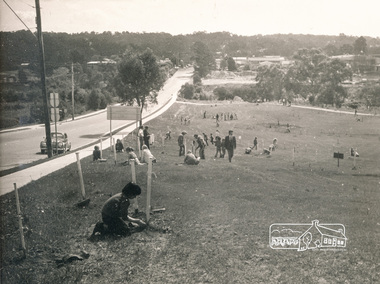
Photograph, ELTHAM ARBOR DAY 1973 - Alistair Knox with school children of the Shire of Eltham, Vic, planting native trees in the Town Park, 10 October 1973, 1973-10-10
ELTHAM - ARBOR DAY, 10 Oct 1973. School children of the Shire of Eltham planting trees (previously planned to take place during the visit of Sir Rohan Delacombe to the Shire on 19th September, 1973 but cancelled that day due to inclement weather). REF: 783 SOURCE: Shire of Eltham (Eltham District Historical Society) Eltham Town Park would later be renamed Alistair Knox ParkBlack and white photographeltham, arbor day, alistair knox, alistair knox park, eltham town park, bridge street -
 Eltham District Historical Society Inc
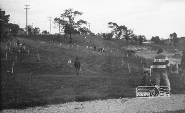
Photograph, ELTHAM ARBOR DAY 1973 - Alistair Knox with school children of the Shire of Eltham, Vic, planting native trees in the Town Park, 10 October 1973, 1973-10-10
ELTHAM - ARBOR DAY, 10 Oct 1973. School children of the Shire of Eltham planting trees (previously planned to take place during the visit of Sir Rohan Delacombe to the Shire on 19th September, 1973 but cancelled that day due to inclement weather). REF: 783 SOURCE: Shire of Eltham (Eltham District Historical Society) Eltham Town Park would later be renamed Alistair Knox Park Main Road to left and Bridge Street to right - looking southeastBlack and white photographeltham, arbor day, alistair knox, alistair knox park, eltham town park, main road, bridge street -
 Eltham District Historical Society Inc
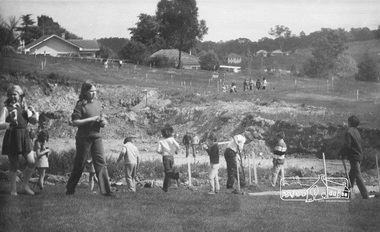
Photograph, ELTHAM ARBOR DAY 1973 - Alistair Knox with school children of the Shire of Eltham, Vic, planting native trees in the Town Park, 10 October 1973, 1973-10-10
ELTHAM - ARBOR DAY, 10 Oct 1973. School children of the Shire of Eltham planting trees (previously planned to take place during the visit of Sir Rohan Delacombe to the Shire on 19th September, 1973 but cancelled that day due to inclement weather). REF: 783 SOURCE: Shire of Eltham (Eltham District Historical Society) Eltham Town Park would later be renamed Alistair Knox Park Bridge Street in backgroundBlack and white photographeltham, arbor day, alistair knox, alistair knox park, eltham town park -
 Eltham District Historical Society Inc
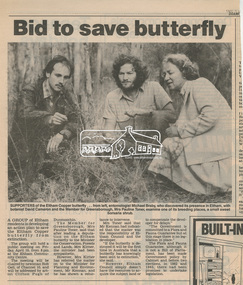
Newsclipping, Bid to save butterfly, Diamond Valley News, 1987, 1987
Local Newspaper article promoting a community meeting for the purposes of developing an action plan to save the Eltham copper Butterfly from extinction after its discovery in its breeding place, the sweet bursaria shrub. Michael Braby, David Cameron and Pauline Toner M.P. are pictured. Early 1987. After the re-discovery of the rare Eltham copper Butterfly in large numbers in Eltham in 1987 Pauline Toner M.P. worked to preserve its habitat. Her work is recognised in the naming of the Pauline Toner Butterfly Reserve on the corner of Pitt Street and Eucalyptus Road in ElthamDigital file only - Digitised by EDHS from a scrapbook on loan from Beryl Bradbury (nee Stokes), daughter of Frank Stokes.beryl bradbury (nee stokes) collection, david cameron, eltham copper butterfly, michael braby, pauline toner -
 Eltham District Historical Society Inc
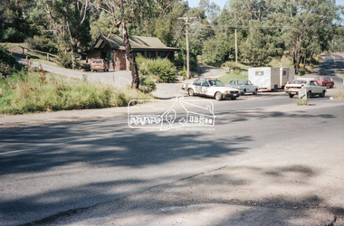
Negative - Photograph, Intersection of Mt Pleasant Road at Main Road, Eltham, c.Dec. 1983
Reconstruction work was planned for Main Road to install a roundabout at Mount Pleasant Road. Traffic to Lower Plenty and Templestowe to be diverted down Bridge Street (and Bolton Street) effective January 1984. The proposed roundabout did not proceed. Instead traffic islands on Mount Pleasant Road were installed in place of temporary blocked out islands and revised extended driveway to properties 622-642 Main Road with access off Mount Pleasant Road instead.Film - Kodak CM 400 5079 7 strips, 26 framesinfrastructure, roads, road construction, roundabout, road sign, main road, mount pleasant road, eltham -
 Eltham District Historical Society Inc
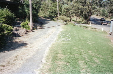
Negative - Photograph, Intersection of Mt Pleasant Road at Main Road, Eltham, c.Dec. 1983
Reconstruction work was planned for Main Road to install a roundabout at Mount Pleasant Road. Traffic to Lower Plenty and Templestowe to be diverted down Bridge Street (and Bolton Street) effective January 1984. The proposed roundabout did not proceed. Instead traffic islands on Mount Pleasant Road were installed in place of temporary blocked out islands and revised extended driveway to properties 622-642 Main Road with access off Mount Pleasant Road instead.Film - Kodak CM 400 5079 7 strips, 26 framesinfrastructure, roads, road construction, roundabout, road sign, main road, mount pleasant road, eltham