Showing 920 items
matching suburban
-
 Eltham District Historical Society Inc
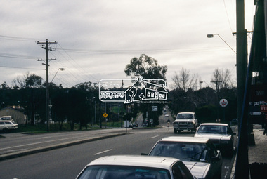
Slide - Photograph, Main Road, Lower Plenty, c.Aug. 1990
Part of a presentation, "Roads and Byways of the Shire of Eltham", by Russell Yeoman to the 12 September 1990 Society meeting. Slides shown included copies of old photos and recent images ranging from the suburban streets of Eltham and Montmorency to the mountain roads of Kinglake. In the byways category are views of some iof the Shire's bicycle paths including then recently completed sections of the Main Yarra Trail at Lower Plenty.35mm colour positive transparency (1 of 37) Mount - Agfachrome Agfa CS System black 8 dotsinfrastructure, lower plenty, roads, edward willis court, main road -
 Eltham District Historical Society Inc
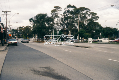
Slide - Photograph, Grand Boulevard, Montmorency, c.Aug. 1990
Part of a presentation, "Roads and Byways of the Shire of Eltham", by Russell Yeoman to the 12 September 1990 Society meeting. Slides shown included copies of old photos and recent images ranging from the suburban streets of Eltham and Montmorency to the mountain roads of Kinglake. In the byways category are views of some iof the Shire's bicycle paths including then recently completed sections of the Main Yarra Trail at Lower Plenty.35mm colour positive transparency (1 of 37) Mount - Agfachrome Agfa CS System black 8 dotsinfrastructure, roads, grand boulevard, montmorency -
 Eltham District Historical Society Inc
Slide - Photograph, Kangaroo Ground Supply Store, Eltham-Yarra Glen Road, Kangaroo Ground, c.Aug. 1990
Part of a presentation, "Roads and Byways of the Shire of Eltham", by Russell Yeoman to the 12 September 1990 Society meeting. Slides shown included copies of old photos and recent images ranging from the suburban streets of Eltham and Montmorency to the mountain roads of Kinglake. In the byways category are views of some iof the Shire's bicycle paths including then recently completed sections of the Main Yarra Trail at Lower Plenty.35mm colour positive transparency (1 of 37) Mount - Agfachrome Agfa CS System black 8 dotsinfrastructure, roads, eltham-yarra glen road, kangaroo ground, kangaroo ground store, kangaroo ground supply store -
 Eltham District Historical Society Inc
Slide - Photograph, Eltham-Yarra Glen Road, Kangaroo Ground, c.Aug. 1990
Part of a presentation, "Roads and Byways of the Shire of Eltham", by Russell Yeoman to the 12 September 1990 Society meeting. Slides shown included copies of old photos and recent images ranging from the suburban streets of Eltham and Montmorency to the mountain roads of Kinglake. In the byways category are views of some iof the Shire's bicycle paths including then recently completed sections of the Main Yarra Trail at Lower Plenty.35mm colour positive transparency (1 of 37) Mount - Agfachrome Agfa CS System black 8 dotsinfrastructure, roads, eltham-yarra glen road, kangaroo ground, kangaroo ground store, kangaroo ground supply store -
 Eltham District Historical Society Inc
Slide - Photograph, Shopping Centre, Main Road, Eltham, c.Aug. 1990
Part of a presentation, "Roads and Byways of the Shire of Eltham", by Russell Yeoman to the 12 September 1990 Society meeting. Slides shown included copies of old photos and recent images ranging from the suburban streets of Eltham and Montmorency to the mountain roads of Kinglake. In the byways category are views of some iof the Shire's bicycle paths including then recently completed sections of the Main Yarra Trail at Lower Plenty.35mm colour positive transparency (1 of 37) Mount - Agfachrome Agfa CS System black 8 dotsinfrastructure, roads, eltham, luck street, main road, shopping centre -
 Eltham District Historical Society Inc
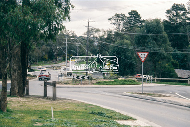
Slide - Photograph, Main Road, Research, c.Aug. 1990
Part of a presentation, "Roads and Byways of the Shire of Eltham", by Russell Yeoman to the 12 September 1990 Society meeting. Slides shown included copies of old photos and recent images ranging from the suburban streets of Eltham and Montmorency to the mountain roads of Kinglake. In the byways category are views of some iof the Shire's bicycle paths including then recently completed sections of the Main Yarra Trail at Lower Plenty.35mm colour positive transparency (1 of 37) Mount - Agfachrome Agfa CS System black 8 dotsinfrastructure, roads, ingrams road, main road, raglan road, research (vic.) -
 Eltham District Historical Society Inc
Slide - Photograph, Ingrams Road, Research, c.Aug. 1990
Part of a presentation, "Roads and Byways of the Shire of Eltham", by Russell Yeoman to the 12 September 1990 Society meeting. Slides shown included copies of old photos and recent images ranging from the suburban streets of Eltham and Montmorency to the mountain roads of Kinglake. In the byways category are views of some iof the Shire's bicycle paths including then recently completed sections of the Main Yarra Trail at Lower Plenty.35mm colour positive transparency (1 of 37) Mount - Agfachrome Agfa CS System black 8 dotsinfrastructure, roads, ingrams road, research (vic.), research preschool -
 Eltham District Historical Society Inc
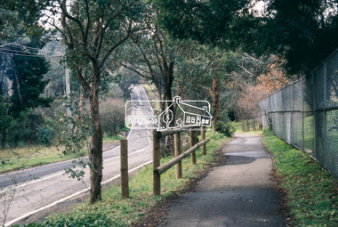
Slide - Photograph, Eltham-Yarra Glen Road, Research, c.Aug. 1990
Part of a presentation, "Roads and Byways of the Shire of Eltham", by Russell Yeoman to the 12 September 1990 Society meeting. Slides shown included copies of old photos and recent images ranging from the suburban streets of Eltham and Montmorency to the mountain roads of Kinglake. In the byways category are views of some iof the Shire's bicycle paths including then recently completed sections of the Main Yarra Trail at Lower Plenty.35mm colour positive transparency (1 of 37) Mount - Agfachrome Agfa CS System black 8 dotsinfrastructure, roads, research (vic.), cassells road, eltham-yarra glen road -
 Eltham District Historical Society Inc
Slide - Photograph, Eltham-Yarra Glen Road, Research, c.Aug. 1990
Part of a presentation, "Roads and Byways of the Shire of Eltham", by Russell Yeoman to the 12 September 1990 Society meeting. Slides shown included copies of old photos and recent images ranging from the suburban streets of Eltham and Montmorency to the mountain roads of Kinglake. In the byways category are views of some iof the Shire's bicycle paths including then recently completed sections of the Main Yarra Trail at Lower Plenty.35mm colour positive transparency (1 of 37) Mount - Agfachrome Agfa CS System black 8 dotsinfrastructure, roads, research (vic.), eltham-yarra glen road -
 Eltham District Historical Society Inc
Slide - Photograph, Catherine Court, Eltham, c.Aug. 1990
Part of a presentation, "Roads and Byways of the Shire of Eltham", by Russell Yeoman to the 12 September 1990 Society meeting. Slides shown included copies of old photos and recent images ranging from the suburban streets of Eltham and Montmorency to the mountain roads of Kinglake. In the byways category are views of some iof the Shire's bicycle paths including then recently completed sections of the Main Yarra Trail at Lower Plenty.35mm colour positive transparency (1 of 37) Mount - Agfachrome Agfa CS System black 8 dotsinfrastructure, roads, catherine court, eltham -
 Kew Historical Society Inc
Headwear - Iridescent Feather 'Saucer' Hat, 1950s
The 'flat' hat dominated millinery design in the 1950s. Most women sourced their hats from numerous Melbourne or suburban milliners while others purchased the products of French designers. A number of Australian companies were licensed to reproduce French designs. In very rare cases, Australian women purchased directly from a French couturier's collection. This inverted flat 'saucer' hat is an example of the latter.The Kew Historical Society’s fashion and design collection is comprised of costumes, hats, shoes and personal accessories. Many of these items were purchased or handmade in Victoria; some locally in Kew. The extensive hat collection comprises items dating from the 1860s to the 1970s. While most of the hats in the collection were created by milliners for women, there are a number of early and important men’s hats in the collection. The headwear collection is particularly significant in that it includes the work of notable Australian and international milliners. This feather hat was donated by Marion Blatchley, a resident of 7 John Street, Kew, a member of the Society, and a collector of vintage fashion items. In terms of fine workmanship, it is the highest quality hat in the collection.A fashionably flat woman’s hat with an inverted rim. The whole is covered in tiny iridescent dark feathers. A numbered label stitched to the interior of the hat identifies that the hat was made in Paris, France. The label includes a stamped number 9102 and a handwritten ‘Col 10’.Label: Stamped number 9102 and a handwritten ‘Col 10’.hats, women's clothing, costume accessories, french fashion - 1950s -
 Melbourne Tram Museum
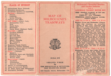
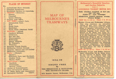
Map, Melbourne & Metropolitan Tramways Board (MMTB), "Map of Melbourne Tramways", 1934
Map booklet consists of three pages of bus and tram round trips, 3 center pages for a map of electric and cable trams, route numbers, and points of interest. Has 4 pages giving an index to routes and first and last trams to and from the City. Shows points where suburban routes are intersected by City routes. One page of places of interest. Dated 1934/35.Demonstrates methods of giving information to visitors to Melbourne and yields information about tram services at the time in Melbourne.Map - 2 octavo cards stapled and folded into 12 pages. All printing is in black with red headings and highlights except for the map which is in four colours.tramways, trams, mmtb, map, timetables, tourist trips -
 Kew Historical Society Inc
Photograph - 'Mynda', 5 Molesworth Street, 1979
'A suburban villa of 1885 designed by Lloyd Tayler for his daughter and son-in-law on a plan centred upon an octagonal top-lit hall. A square bay window to the drawing room projects from the front corner of the house at 45 degress, showing for the first time the diagonal emphasis which was to be developed in other works of the architect and to become in due course a characteristic of the Federation Style.' (National Trust Victoria Citation)Original colour positive photograph (Kodak print) of the front garden of 'Mynda', 5 Molesworth Street, KewInk on reverse: "Miss Anderson's / No.5 Molesworth St. / Cottage garden / Taken and ***"historic gardens -- kew (vic.), mynda, 5 molesworth street -- kew (vic.) -
 Kew Historical Society Inc
Photograph - Opening of the Dorothy Rogers Reserve, 1976
Dorothy Rogers wrote two major books on Kew's history: Lovely Old Homes of Kew (1961) and A History of Kew (1973). In addition to her published works, she was a regular contributor on issues of local history to suburban newspapers. Her archives are held in the collections of the State Library of Victoria and Kew Historical Society. Three years after her death in 1973, the Reserve was opened in her honour.Faded colour positive photograph of the opening of the Dorothy Rogers Reserve in 1976. The naming of the reserve honoured the contribution of the historian Dorothy Rogers, foundation member of the Society. The reserve is located on the north side of Studley Park Road just west of Kew Junction. Inscribed verso: "Members and relatives of the late Dorothy Rogers. Memorial reserve named and unveiled in her honour by (Cr Whiting Mayor) and City Manager Mr Fell 1978. In respect for her great research and service to the history of early Kew, and other places."dorothy rogers reserve, public parks -- kew (vic.) -
 Kew Historical Society Inc
Photograph - Opening of the Dorothy Rogers Reserve, 1976
Dorothy Rogers wrote two major books on Kew's history: Lovely Old Homes of Kew (1961) and A History of Kew (1973). In addition to her published works, she was a regular contributor on issues of local history to suburban newspapers. Her archives are held in the collections of the State Library of Victoria and Kew Historical Society. Three years after her death in 1973, the Reserve was opened in her honour.Faded colour positive photograph of the opening of the Dorothy Rogers Reserve in 1976. The naming of the reserve honoured the contribution of the historian Dorothy Rogers, foundation member of the Society. The reserve is located on the north side of Studley Park Road just west of Kew Junction. Inscribed verso: "Left to right: Mrs Rogers Jnr, Joy Stewart, Miss Jenkins sitting / Mrs Richardson and Mr Richardson, Brother of D. Rogers), Mayor Cr Whiting, City Manager Mr Fell, Background / KHS President Miss Hall, Mr B O'Neill KHS member, / taken during the memorial unveiling of the Dorothy Rogers Reserve"dorothy rogers reserve, public parks -- kew (vic.) -
 Melbourne Tram Museum
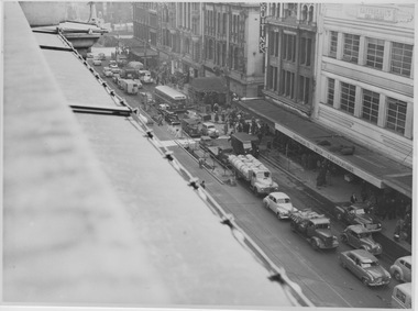
Album - City Traffic Congestion, Various dates September 1954
Six photographs showing traffic congestion that detains progress of trams in city streets. Road traffic congestion that detained tramcars in the city centre and on selected suburban roads had been a major concern to tramway operators dating back to the early 1900s. During the 1960s, and perhaps earlier, the Tramways Board regularly proposed ways of keeping motor traffic off the trams tracks, but little progress was achieved.Yields information about the perennial issue of motor traffic detaining trams. Incomplete series of photographs showing street traffic congestion in Flinders Street and Spencer Street5. Date 10/9/54, Time 1355 hrs, Flinders St, from Railway Buildings looking West over Degraves St. General traffic clear of tram tracks. 7. Date 17/9/54, Time 1355 hrs, Flinders St, from Railway Buildings looking West near Degraves St. 2 cars, 1 truck & 1 van parked & unattended. All moved within ten minutes. 8. Date 17/9/54, Time 1359 hrs, Flinders St, from Railway Buildings looking East towards Swanston St. Two utilities parked & unattended outside SEC. (Note policeman directing traffic.) See also Photo No 9. 9. Date 17/9/54, Time 1417 hrs, Flinders St, from Railway Buildings looking East towards Swanston St. Progressive view to No 8, two utilities in same position after 18 minutes. 12. Date 17/9/54, Time 1431 hrs, Flinders St, from Railway Building, Safety Zone at Swanston St. Progressive view to No 11 (missing from this album). Front truck about to leave after 10 minutes, rear truck remained parked. 11. Date 28/9/54, Time 0910 hrs, Spencer St, from roof of J S Gordon's near Flinders Lane, looking South. Three Northbound & 2 Southbound tramcars held up by truck caught in Southbound traffic when turning into lane. congestion, flinders st, spencer st, motor traffic -
 Warrnambool and District Historical Society Inc.
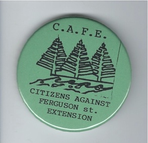
Badge, Citizens against Ferguson St Extension
This badge was issued to supporters of the 1980s campaign called ‘Citizens Against Ferguson Street Extension’. Ferguson Street is in East Warrnambool and at the time the road was formed but there were no houses on the north side. The proposal was to extend the street at the north east end so that access could be made to east Warrnambool and Deakin University. The local residents opposed the proposal because it would increase traffic in the quiet suburban areas. The scheme did not go ahead. This badge is of minor interest as an example of a local campaign against an unpopular City Council proposal. This is a green circular-shaped badge made of plastic. It has black printing with a sketch of three Norfolk Island pine trees on the front and a metal clip at the back for attachment to a person’s clothing. The back has an image of a map of Australia.‘C.A.F.E. Citizens Against Ferguson St. Extension’ ferguson street, history of warrnambool -
 Hume City Civic Collection
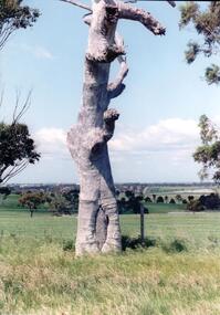
Photograph, early 1990's
The scarred tree is located on a hillside in a local reserve. The bark has been removed in the past to make a boat or other large utensil. Melbourne's skyline can be seen faintly in the distance in the middle of the photograph with local suburban development in the middle distance. The set of 20 photographs were taken of a number of archaeological ands sacred sites in the Bulla district. The photographs were included in a study published by the Shire of Bulla in the early 1990's.A scarred tree aboriginal ring sites, george evans collection -
 Vision Australia
Administrative record - Text, Royal Victorian Institute for the Blind annual report 1967-1968, 1967-1968
Events that occurred in 1967 : Eight suburban craft centres for elderly blind people were established allowing a half day each week for people, the institute's secretary E.E. Petersen went on a study tour overseas, F.F. Knight senior Vice President and member of the board for more than seventeen years was honored for his work with a CBE, and the Insurance Institute of Victoria met the cost of a 16mm version of the film "A matter of independence".1 volume of printed and illustrated materialannual reports, royal victorian institute for the blind -
 Bendigo Historical Society Inc.
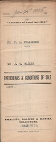
Document - H.A. & S.R. WILKINSON COLLECTION: CONDITION OF SALE
Conditions of sale issued by Smalley, Balmer & Davies solicitors, Swan Hill and dated 24th January 1925 between H. A. Wilkinson as seller and J. G. Walker as buyer. Particulars and conditions of sale of freehold land, particulars: the surface and down to a depth of fifty feet below the surface of all that piece of land being part of Crown Allotment 6 Suburban Section 2 town of Swan Hill, Parish of Castle Donnington County of Tatchera and being the whole of the land described in certificate of title volume 4390 folio 877911. Price 400 pounds.organization, business, h.a. & s.r wilkinson real estate -
 Ballarat Tramway Museum
Map, Melbourne and Metropolitan Tramways Board (MMTB), "MMTB Map of Melbourne Tramways 1934-5", 1934
Demonstrates methods of giving information to visitors to Melbourne and yields information about tram services at the time in Melbourne.Very small pocket sized timetable and map book, consisting of 2 octavo cards stapled and folded into 12 pages consisting of three pages of bus and tram round trips, 3 center pages for map of electric and cable trams, route numbers and interest points. Map printed in 4 colours. 4 pages index to routes and first and last trams to City and from City. Also gives points where suburban routes are intersected by City routes. One page devoted to places of interest. All printing in black with red headings and highlights.trams, tramways, mmtb map, mmtb, timetables, tourist trips, map -
 Bendigo Historical Society Inc.
Document - LANDS OFFICE: SANDHURST CROWN LAND SOLD BY AUCTION 1854
Document: LANDS OFFICE: SANDHURST CROWN LAND SOLD BY AUCTION 1854 booklet - brown paper cover with blue pages. On front cover ' copy of sale books, town lots Sandhurst, April 18,19,20,21, 22 and 24 also suburban lots on the Bendigo Creek sold May 10TH.? 1854' Booklet contains copies of advertisement for auctions, written alongside, name of purchaser and amount paid per acre. White sticker fixed to pocket ' Book 1, Sandhurst Land Sales, 10 May 1854 to 18 May 1854Lands Officelands office, bendigo, sandhurst, land sales -
 Bendigo Historical Society Inc.
Book - CROWN LAND SALES: RECORDS OF SALE 1860 - 1865
Land sale journal, blue lined pages, no cover. On top of LH page: Crown Land surveyed in the District of Sandhurst. On top of RH page: Crown Lands sold in the District of Sandhurst' Entries contain details of town lands, suburban lands, country lands, total lands surveyed and date of survey. Date of sale, by auction, by selection and total amount paid. Names of purchasers listed. Entries date from 1860 - 1865. Written across all pages in blue pencil 'Cancelled' and a date for each cancellation: Wm. Rundell 8.9.80.bendigo, land sales, sandhurst -
 Vision Australia
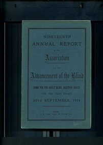
Administrative record - Text, Nineteenth Annual Report of the Association for the Advancement of the Blind 1914, 1914
Annual report of the Association for the Advancement of the Blind outlined activities and events over the year, including the opening of the new wing at the Adult Home for the Blind by Lady Denman, removal of a 300 pound debt due the combined efforts of the Police, Military and Fire Brigades who hosted a monster carnival at Luna Park to raise funds for this, and with the help of the Minister of Railways - Hon. Donald Mackinnon - free suburban train for guides has now been granted.1 volume of printed material with some illustrationsassociation for the advancement of the blind, annual reports -
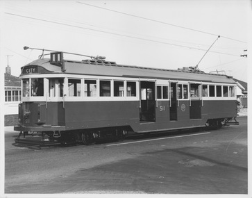 Melbourne Tram Museum
Photograph - W2 class 511 with refreshed livery, c1970s
Photograph of W2 class tram 511 in suburban street displaying destination "City route 11". The tram is fitted with side lights installed in the early 1970s and appears to be freshly painted in green and cream livery. A man stands in the driver's cab hands on controls and the off-side weather blinds are down, but no passengers or conductor appear to be in the tram. The incorrect destination and lack of run number and passengers suggest the tram is being moved by workshop staff.Yields information about W2 class tram in 1970s. Black and white photograph with nothing on rearw2 class, tram number 511, city route 11, side lights, livery, workshop staff -
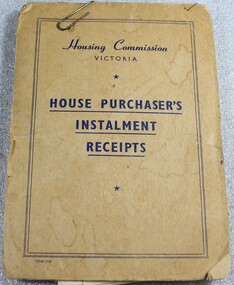 Wodonga & District Historical Society Inc
Financial record - Housing Commission Victoria House Purchaser's payment book, C. 1950's
The Housing Commission of Victoria (HCV) was established by the Victorian Government in 1938 after a public campaign for housing reform. After 1942 the HCV was responsible for developing regional and outer suburban housing estates where low-income families were located in proximity to expanding population areas and post-war industries. With greater funding and a severe housing shortage, the Commission's activities greatly expanded through the late 1940s into the 1950s. They began to build larger and larger estates of housing in the suburban fringes, as well as country towns The Housing Commission was largely responsible for the development of Wodonga up to 1973 and in 1975 was said to have built one-third of all homes in Wodonga, though many of these were handed to the Army. Criticism of the bureaucratic and undemocratic nature of the Commission and scandals over corruption in relation to housing developments in Melbourne's fringe areas resulted in the disbandment of the HCV and the formation of a Ministry of Housing in 1984. The work of the Housing Commission of Victoria allowed many people in Wodonga to acquire affordable housing and pay it off over time through monthly instalments. This booklet is of local and state significance as it is evidence of the role of the Victorian Government is providing access to affordable housing. It supported the development of Wodonga and the realisation of the "Australian dream" of home ownership.A small receipt book issued by the Housing Commission of Victoria to record payments and receipts for tenants who were purchasing their home through the Housing Commission. Monthly installments allowed people to access and purchase, affordable housing. On the front cover "Housing Commission/VICTORIA/ HOUSE PURCHASER'S/ INSTALMENT/RECEIPTS"housing wodonga, housing commission of victoria, public housing wodonga -
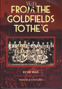 Warrnambool and District Historical Society Inc.
Book, Kevin Reed, From the Goldfields to the G, 2014
An account of the development of Australian Rules football in both rural and suburban Victoria.This is a paper back book with a red and gold cover with a photograph of Costerfield Football Team, 1919 on the cover (335 pages) The book is signed inside by Kevin Reed non-fictionAn account of the development of Australian Rules football in both rural and suburban Victoria.warrnambool, kevin reed, dr john douglas, warrnambool cricket 1980's, warrnambool football 1970's 1980's -
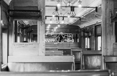 Eltham District Historical Society Inc
Photograph, George Coop, Interior of a Red Rattler Tait train passenger carriage, 22 August 1983, 1983
Note the graffiti. Older 20th.c and earlier railway cars were rolling palaces of the cabinet makers art. Full of polished timber, plated & embossed metal fittings, soft upholstery & beveled glass. In their earliest form, the Tait’s and earlier swing door cars for even modest suburban work, reflected some level of this design approach. Plus of course large sepia toned photographs on dividing walls displaying tourist spots trains could take you to.Digital TIFF file Scan of 35mm Kodak Safety 5062 black and white transparencygraffiti, interior, passenger carriage, red rattler, tait train