Showing 666 items matching "survey plan"
-
 Federation University Historical Collection
Map, Town of Buninyong, 1927, 09/1927
The date of this map is September 1927 revised from the original 1910 map. Buninyong was created a district on 09 July 1858, proclaimed a Shire on 16 February 1864, and the Buninyong Borough united on 01 October 1915.Township plan of the Town of Buninyong showing government roads and crown allotments. Earlier detail pencilled on (commercial buildings, etc) appears to be from an 1850 survey. Scale: 4 chains to 1 inch (1:3168)buninyong, map, buninyong botanical gardens, tannery dam, buninyong reservoir, chapel school, rev. hastie -
 Federation University Historical Collection
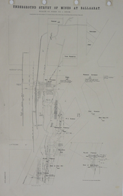
Plan, Underground Survey of Mines at Ballarat, 1886, 1886
Plan showing the streets of Ballarat (Sebastopol Street, LaTrobe Street, Drummond Street, Errard Street). Mines include Williams' Freehold, Band of Hope Quartz, Wilson's Freehold, Smith's Freehold, Washington Freehold, Kohinoor No. 2, East Korinoor, Burra Burra No 1, Wareham's, Hawthorne's, Jones', Young Washington, New Kohinoor, Benn's,plan, mining, cgt, williams' freehold, band of hope quartz, wilson's freehold, smith's freehold, washington freehold, kohinoor no. 2, east korinoor, burra burra no 1, wareham's, hawthorne's, jones', young washington, new kohinoor, benn's -
 Federation University Historical Collection
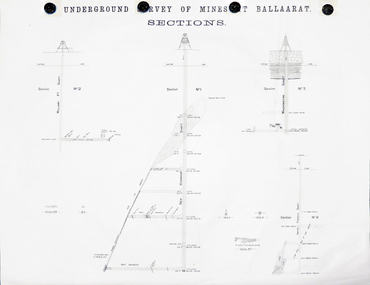
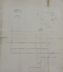
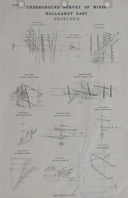
Plan, Underground Survey of Mines at Ballarat Sections
A plan showing the underground sections of the Washington Shaft, Smith's Freehold Shaft and the New Kohinoor Shaft.plans, mining, cgt, washington shaft, smith's freehold shaft, new kohinoor shaft, koh-i-nor -
 Federation University Historical Collection
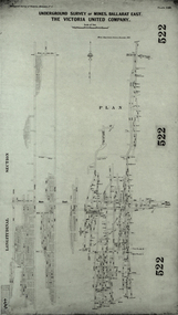
Plan, Underground Survey of Mines, Ballarat East. The Victoria United Company, 1903
Underground Survey of The Victoria United Company from Geological Survey of Victoria, Memoirs No. 4.ballarat east, victoria united company, cgt, mining, geological survey, longitudinal section -
 Federation University Historical Collection
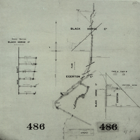
Plan, Black Horse Co
Plan showing a plan and cross section of the Black Horse Co. It also shows the Egerton Co, black horse co, cgt, mining, geological survey, cross section, egerton co -
 Flagstaff Hill Maritime Museum and Village
Document - Navigation Chart, Admiralty Office, Lady Bay and Warrnambool Harbour, 1893
This navigation cart of Lady Bay and Warrnambool Harbour was originally surveyed in 1870 but this version includes the update for magnetic variation in 1893. Since the printing of the chart several annotations have been added. These include an additional stamp dated 15-8-1910, a handwritten comment across the top of the page dated August 1910, and another handwritten comment regarding the ‘Proposed Extension of Dock’ dated 19-2-1925, plus connected drawings, notes and figures. The 1925 proposal on this chart may have been a reaction to the Royal Commission of 1923, when the damaged stonework on the seaward side of the Warrnambool Breakwater, caused by the action of the sea, was the subject of enquiry. A conference between the Public Works, Water Commission and the Harbour Trust concluded that it would less costly to make repairs to prevent further damage rather than replaced the damage portion of the wall. A contract was raised in late 1924 to deposit rubble on the damaged side of the breakwater to minimise the Southern Ocean’s destructive action and work had started by August 1925. The Breakwater construction had begun in 1874 and was completed in 1890. The Victorian Government had commissioned Sir John Coode, a British harbour engineer, to present a plan to complete the Warrnambool Breakwater but his original plan was too expensive. He prepared a revised plan for a shorter structure. The construction proved to be too short to protect adequately from the weather and didn't allow enough depth for larger vessels to come into port. The decreasing trade was further affected by siltation in the bay due to the breakwater, and the completion of the railway line. The situation of the harbour became a real problem by 1910 and required continuous dredging. In 1914 the Breakwater was extended but proved to be a failure because the work began to subside and by 1920 about two thirds of the harbour was silted up. Alterations made in the 1920's increased the silting problem and by the 1940's the harbour was no longer used. More alterations were made in the 1950's and 1960's. This chart is significant for its strong connection to the maritime history of Warrnambool Harbour and Lady Bay and the Warrnambool Breakwater. The Warrnambool Breakwater is registered as a place of significance on the Victorian Heritage Database (VHR H2024). The Warrnambool Breakwater is one of the most important late 19th century maritime engineering projects in Victoria and significant in the development of Victorian coastal shipping. It is also significant for its connection with British harbour engineer, Sir John Coode. The chart is a historical record of structures existing in 1893; the Warrnambool Jetties, Warrnambool Breakwater in Lady Bay, the leading lights (lighthouses), streets, roads, bridges and many buildings. It also shows the lay of the land and seabed. Navigation Chart: Lady Bay and Warrnambool Harbour, Australia - South Coast - Victoria. Surveyed by Nav. Lieut. H.J. Stanley, R.N., 1870. Updated for Magnetic Variation, 1893. The rectangular chart is printed on heavy cream paper. Stamps are shaped rectangular, oval and round. Around the Breakwater and Jetty area are handwritten notes, dotted and joined lines, numbers and signatures, and shading of red and green. The chart shows the surrounds of Warrnambool Harbour, Lady Bay, the Breakwater and Jetty, roads, bridges and the streets in Warrnambool. It has sounding details, and angles of line from the leading lights.Stamp, rectangular, including "AUG 1910" Stamp, double oval " - - - -CHART" Stamp, hand drawn, red circle, with "B" inside Hand written note "22-8-1910 - - - - - of surveying C. Ca - - - request of 15-8-10 [initials] " Notes and lines in red pen, including a grid of sounding numbers: "1300" "1050" "1200" "Possible Extension of Dock" "19-2-25" "Dock Dredged to 20 Ft" Notes and lines in blue pen "Extension of Dock to accommodate vessels drawing 20 Feet" and "Light not visible south of this line" Red dots (4) with yellow highlight at both leading lights, breakwater and jettyflagstaff hill, warrnambool, flagstaff hill maritime museum & village, maritime museum, maritime village, shipwreck coast, map, chart, navigation chart, plan, lady bay, warrnambool harbour, port of warrnambool, breakwater, jetty, pier, dock extension, proposed extension, vhr h2024, 1870, 1893, 1910, 1925, warrnambool town late 1800s, warrnambool streets late 1800s royal commission, 1923, public works, water commission, harbour trust, victorian harbours, sir jon coode -
 Flagstaff Hill Maritime Museum and Village
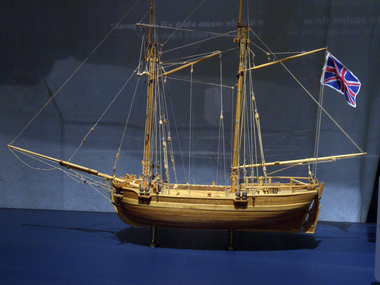
Craft - Ship Model, H.M.S. Lady Nelson, 1988
This model of the ship H.M.S. Lady Nelson was researched and built as the vessel Lady Nelson by David Lumsden, a professional ship model builder. His Majesty's Armed Survey Vessel Lady Nelson was commissioned in 1799 to survey the coast of Australia. This vessel was purpose-built before the British Admiralty requested plans for a Schooner for Port Jackson. At the time large parts of the Australian coast were unmapped and Britain had claimed only part of the continent. The British Government were concerned that, in the event of settlers of another European power becoming established in Australia, any future conflict in Europe would lead to a widening of the conflict into the southern hemisphere to the detriment of the trade that Britain sought to develop. Against this background, Lady Nelson was chosen to survey and establish sovereignty over strategic parts of the continent. Lady Nelson left Portsmouth on 18 March 1800 and arrived at Sydney on 16th December 1800 after having been the first vessel to reach the east coast of Australia via the Bass Strait. Before that date, all vessels had sailed around the southern tip of Tasmania to reach their destination. Lady Nelson's survey work commenced shortly after she arrived in Sydney, initially in the Bass Strait area. She was involved in the discovery of Port Phillip, on the coast of Victoria, in establishing settlements on the River Derwent and at Port Dalrymple in Tasmania. She also successfully chartered much of the Victorian coastline and was heavily involved with the exploration of the Queensland coast with Matthew Flinders; investigated the Hunter River; made numerous visits to New Zealand and Norfolk Island and was involved in the founding of numerous settlements. In comparison to most colonial vessels, the Lady Nelson was technically unique she was fitted with sliding keels, or centreboards, and water-tight trunks reaching to the deck. Captain Schank invented these sliding keels that, when raised, reduced her draught to less than six feet. Her life as an exploration vessel ended while accompanying HMS 'Tamar' to Melville Island in 1825, the 'Lady Nelson' was captured and later abandoned by pirates off the island of Babar (Indonesia). This brought the vessel's 25 years of coastal exploration and navigation to a close.The Lady Nelson made was the first British ship to survey of the southern or south-western coast of Australia and traverse the Bass Strait. The vessel holds a special place in Australia's history of exploration as the first to explore and establish settlements in the then-new British colony of Van Diemans Land. The model gives an insight into what life must have been like onboard sailing vessels of the time and Australia's early history of establishment and exploration. This model acts as an important legacy of the full-scale ship which no longer survives. Ship model of the 60 ton British brig HMS Lady Nelson. Timber model of a two-masted brig with rigging but no sails, displaying the British Union Jack flag. The ship is in a glass exhibition display case on metal stand. HMS Lady Nelsonflagstaff hill, warrnambool, shipwrecked coast, flagstaff hill maritime museum, maritime museum, shipwreck coast, flagstaff hill maritime village, great ocean road, by captain john schanck, sliding keels or centreboards, lady nelson, british brig hms lady nelson, david lumsden ship model builder, lieutennant james grant, bass strait discovery, surveying king island and port phillip bay, philip gidley king -
 Federation University Historical Collection
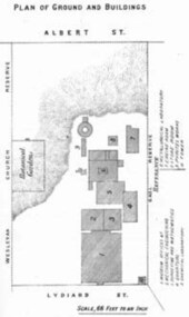
Book - Annual Report 1880, The School of Mines Ballaarat Annual Report, 9 February, 1880, 1880
The School of Mines Annual Report, 9 February, 1881, Additional Examination Statute 1880, Balance Sheet, Certificates Granted by Council, Donations and Fees - carriage of, Extracts from Visitors' Book, Fees, Form of Bequest, Honorary Correspondents, Life Governors, Mining and Mineral Contributions Invited - Paper of Particulars, Museum - open to visitors, Office Bearers, Obituary, Report of the Lecturer in Mathematics, Report of the Lecturer in Mining-Land- and Engineering-Surveying, Report of the Lecturer in Mechanical Engineering, Report of the Lecturer in Telegraphy, Report of the Curator of the Museum (with Plans), Report of the Superintendent of Laboratories, Subjects and Lecturers, Subjects and Examiners, Statement of Receipts and Expenditure for the year 1880, Subscriptions and Donations from 1 January to 31 December 1880, The Lal-Lal Iron Ore Deposits - (with Section and Plan)Pale green booklet of 70 pages, Annual Report 1880. Image of Guage Test Tower, Image of The School of Mines, Plan of Ground and Buildings - Albert Street, The School of Mines Ballaarat - The Museum - Plan of Groundfloor, Image of the Lal-Lal Iron Ore Deposits, Moorabool Riverthe school of mines, annual report, additional examination statute 1880, balance sheet, certificates granted by council, donations and fees - carriage of, extracts from visitors' book, fees, form of bequest, honorary correspondents, life governors, mining and mineral contributions invited-paper of particulars, museum open to visitors, office bearers, obituary, report of the lecturer in mathematics, report of the lecturer in mining-land and engineering-surveying, report of the lecturer in mechanical engineering, report of the lecturer in telegraphy, report of the curator of the museum (with plans), report of the superintendent of laboratories, subjects and lecturers, subjects and examiners, statement of receipts and expenditure for the year 1880, subscriptions and donations from 1 january to 31 december 1880, the lal-lal iron ore deposits-(with section and plan), obituary - sir redmond barry - arthur leahy - jacob upfold - john day, mr james oddie, dr. r. f. hudson, john victor, chas. wm. thomas, w. h. shaw, walter d. campbell, ferdinand m. krause, joseph flude, geo. perry, w. hy. barnard, examination statute, his excellency sir wm. f. drummond jervois, charles h. pearson, t. brodribb, professor pepper, james mitchell, robert adam, wm. lant carperter, h. b. de la poer wall, w. h. brokenshire, arthur parker, henry parkinson, c. davies, simon richards, c. v. gorton, c. r. blackett, david jones, wilberforce dyke, ferdinand krause, ballarat school of mines museum, ballarat school of mines museum plan, lal lal ore deposits, moorabool river, william land carpenter, william jervois, william henry tbarnard -
 Federation University Historical Collection
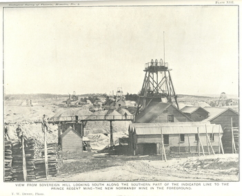
Book, J.W. Gregory, Memoirs of the Geological Survey of Victoria No. 4: The Ballarat East Gold-Field, 1907, 1907
Blue soft covered report with 40 plates and plans. Inciudes Geology of Ballarat. Little Bendigo Goldfield, Ballarat West Goldfield, Ballarat East Goldfield, history, nuggets, indicators, faults, microscopic structure of Ballarat Rocks and ores, general type of the Ballarat East Mines and the genesis of their ores. Mines include New Zealand Trust, Llanberris No. 1, Llanberris No 2, Victoria United, Britannia United, New Britannia, Last Chance, Exchange, Normanby North, New Normanby, North Woah Hawp. Photpgraphic plates include: Victoria United Mine, Llanberres No. 1, Normanby North, North Woah Hawp Mine, View looking south from the Britannia Mullock Heap, View from Sovereign Hill, The place in Learmonth Street Golden Point where gold was first discovered at Ballarat. j.w. gregory, ballarat east, ballarat east goldfield, e.j. dunn, geolological survey of victoria, new zealand trust, llanberris no. 1, llanberris no 2, victoria united, britannia united, new britannia, last chance, exchange, normanby north, new normanby, north woah hawp, mining, indicators, gold mining, poppet head -
 Federation University Historical Collection
Plan - Contour tracings, Ballarat University College residence carparks and detail survey of Mt Helen campus, 1991/1992
3 ink on tracing paper survey maps .1) Detail survey Mt Helen campus 1992 .2) Top residence car park 1991 .3) BUC residences' car park 1991ink on tracing paper, b.u.c surveys, transpotr, ballarat college of advanced education, mount helen campus, carpark, student residences -
 Federation University Historical Collection
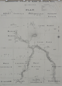
Plan, Underground Survey of Mines at Spring Hill, 1886
Plan printed by the Government Printing Office Melbourne, of underground survey at Spring Hill underground survey, spring hill, robert allen, c.w. langtree, steam litho government printing office -
 Federation University Historical Collection
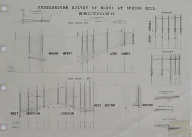
Plan, Underground Survey of Mines at Spring Hill Cross Section No 2, 1886
Plan printed by the Government Printing Office Melbourne, of underground survey at Spring Hill.underground survey, spring hill, steam litho government printing office -
 Federation University Historical Collection
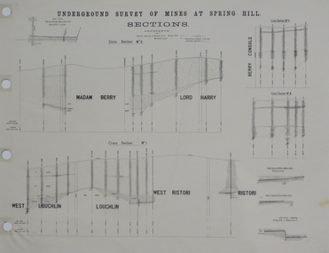
Plan, Underground Survey of Mines at Spring Hill Cross Section No 2, 1886
Plan printed by the Government Printing Office Melbourne, of underground survey at Spring Hill.underground survey, spring hill, steam litho government printing office -
 Federation University Historical Collection
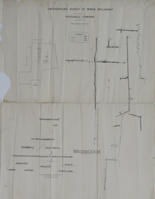
Plan, Underground Survey of Mines, Ballaarat, not dated
... of the Speedwell Company. Underground Survey of Mines, Ballaarat Plan Plan ...Printed transverse section of the Speedwell Company.underground survey, speedwell company -
 Federation University Historical Collection
Plan, Llanberris Co. Transverse Section, not dated
Printed transverse section of the Llanberris Companyunderground survey, llanberris mine, llanberris co, ballarat -
 Federation University Historical Collection
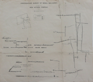
Plan, Underground Survey of Mines Ballaarat, New Victoria Company, not dated
Printed transverse section of the New Victoria Company.underground survey, new victoria company, transverse section, mining, plan -
 Federation University Historical Collection
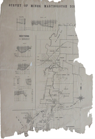
Plan, Survey of Mines, Maryborough District, not dated
Maryborough is a Central Victorian town. Printed section of the Maryborough Districtmaryborough, carisbrook, majorca, horizontal sections, vertical sections, chalk's no 4, east kong meng, craigie -
 Federation University Historical Collection
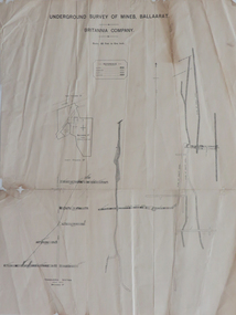
Plan, Underground Survey of Mines, Ballaarat, Britannia Company, not dated
Printed underground survey of the Britannia Companyunderground survey, britannia company, last chance company, transverse section -
 Federation University Historical Collection
Plan, Underground Survey of Mines, Ballaarat East Sections, c1890
... underground survey ballaarat east mining Printed plan showing cross ...Printed plan showing cross sections of various mine shaftsplan, underground survey, ballaarat east, mining -
 Federation University Historical Collection
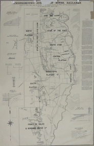
Plan, Underground Survey of Mines, Ballarat, 1887, 1887
... E.J. Barker Library (top floor) Mount Helen goldfields plan ...Printed plan with text down right side and black border, 4 holes top edge and repairsplan, underground survey, robert allen, w. langtree, prince of wales and bonshaw united, bonshaw, south plateau, north plateau, sebastopol plateau, sebastopol star, star of the east, south star, band and albion, owen's freehold, leigh river, yarrowee creek, robert allan, gay's freehold -
Federation University Historical Collection
Report, Integrated Tourism Strategy Plan for the Goldfields Region of Victoria: Volume II: Appendices - Miscellaneous, 10/1995
Black plastic ring binding on an A4 report.goldfields of victoria, goldfields tourism, marketing, goldfields campaign, mining tourism, torusim, tourism strategy, ballarat, bendigo, avoca, maryborough, castlemaine, maldon, community survey -
Federation University Historical Collection
Report, Integrated Tourism Strategy Plan for the Goldfields Region of Victoria, 1994
Black ring binding on an A4 report.goldfields of victoria, goldfields tourism, marketing, goldfields campaign, mining tourism, torusim, tourism strategy, ballarat, bendigo, avoca, maryborough, castlemaine, maldon, community survey, michael pearlman, anastasia molloy, jack harvey, avoca -
Federation University Historical Collection
Report, Goldfields Regional Tourism Development Plan, c1997, 1997
White bound report with clear cover and black plastic ring bindinggoldfields of victoria, goldfields tourism, marketing, tourism, road transport, rail transportair transport, aboriginal cultural heritage, tourism victoria, surveys, applied tourism business project -
Federation University Historical Collection
Book, Jacobs Lewis Vines Architects and Conservation Planners, Historic Sites Survey: Ballarat Study Area, 1980, 1980
This survey was commissioned by the Land Conservation Council, Australian Heritage Commission and the Ministry for Conservation 114 page report on historic sites in the Ballarat region. It includes information on sites, a schexdule of sites, silte selection and designated areas (ie around towns)historic sites, ballarat, wendy jacobs, miles lewis, gary vines, berringa, buninyong, creswick, dunnstown, fiery creek, lal lal, langi logan, cathcart, mount cole, mount egerton, nerrina, gong gong, wombat state forest, railways, explorers routes, early roads, land conservation council, ausralian hertiage commission, department of planning, icomos (burra) charter, nigel lewis, richard aitken, freehold land, public land, langi ghiran, new jubille mine, birthday tunnel mine, pitfield plains, smythesdale, buninyong company, mount clear, mt clear, canadian gully, warrenheip distillery, thomas mitchell, waterloo, trawalla, beaufort, raglan, internment camps, forestry, mining, mining, mt egerton, mary hollick collection, jubilee mine, burra charter, historica areas data form, explorers, egerton company, black horse mine, mt egerton government battery, kaolin mines, anderson brothers, barkstead, anderson's tramway, clarkesdale, berry leads, birthday tunnel mine berringa, warrenheip, australasian company, mount mercer, lanvi-kal-kal, water race -
 Ringwood and District Historical Society
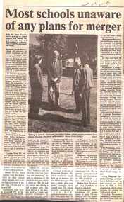
Newspaper, Scrapbook Clipping, Library Collection, Ringwood, Victoria, `
``Newspaper clipping from the "Mail" 5-11-96 P9. Most schools unaware of any plans for merger.Wih the State Government's position well known on school mergers, "The Mail" surveyed Maroondah's schools on the same subject. Most of the surveyed schools said they knew nothing of any planned mergers, or they did not wish to comment. No school said they were in favour of mergers in Maroondah. ` -
 Ringwood and District Historical Society
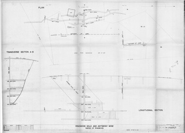
Plan - Department of Mines, Victoria, Ringwood Gold and Antimony Mine - 1921
Technical drawings of Antimony Mine - Plan view, Transverse Section view, and Longitudinal Section view. Includes Main Shaft, No.1 Level 184', No.2 Level 244', No.3 Level 304', No.4 Level 372'. Multiple copies, including copy with overlay of Civic Centre.Scale 40 feet to 1 inch. Surveyed 20-12-21. Traced 1-7-66. W-2568/B/1. -
 Ringwood and District Historical Society
Map, Plan of Country Lands in the Parishes of Nunawading Ringwood and Scoresby - circa 1855
Blueprint copy of Survey Map detailing original Selectors' names and property locations. List of Parish map references including property bearings, distances in Links, and markings on trees. Descriptive remarks include areas marked "Farmer's Common", "Poor soil thickly/moderately timbered with stringy bark", and location of water and firewood reserves."Surveyed and plotted by N.M. Bickford, Superintendant of Mr. Hodgkinson's Field Party". "The land comprised in this survey is of inferior quality, moderately undulating, and thickly wooded. It is watered by Dandenong Creek and Deep Creek." Inset map showing location of (*proposed) cemetery on southern corner of Lillydale Road from Melbourne and Sawmill Road, later Mount Dandenong Road. (*Cemetery did not eventuate.) -
 Ringwood and District Historical Society
Map, Plan of the Parish of Warrandyte County of Evelyn - 1841
Blueprint copy of Survey Map W27 detailing original Selectors' names and property locations between Yarra Yarra River (Warrandyte) and Mullum Mullum Creek (Ringwood). List of Parish map references including property bearings, distances in Links, and markings on trees. Pound Bend area of Warrandyte marked as Reserve For Aborigines. Descriptive remarks include areas marked "scrubby, flat, sandy soil". Several other references faded and illegible.(Map) by T.H. Nutt Feb 3 1841. -
 Ringwood and District Historical Society
Newspaper, Scrapbook Clipping, Library Collection, Ringwood, Victoria
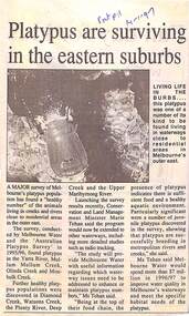
Newspaper Clipping from "The Post", 14 January 1997, Page 11, "Platypus are surviving in the eastern suburbs"'.A major survey of Melbourne's platypus population has found a "healthy number" of the animals living in creeks and rivers close to residential area in the outer east. Conservation and Land Management Minister, Marie Tehan, was present at the launching of the survey results, and spoke in detail about the results and the future planning and financial aid for the health of the Melbourne waterways. -
 City of Moorabbin Historical Society (Operating the Box Cottage Museum)
Buildings, Shingles Original Cottage c1850, c1850
The original small, pioneer cottage was built in the late 1840s to early1850s, by an unknown pioneer. It was located on part of a 30 Acre allotment that was originally part of Henry Dendy’s 'Special Survey Brighton' granted in 1841 (5120acres). There is a small display of external cladding shingles from the original pioneer cottage. Wooden shingles were usually thin (3⁄8 to 3⁄4 in or 10 to 19 mm), relatively narrow (3 to 8 in or 76 to 203 mm), of varying length (14 to 36 in or 360 to 910 mm), and almost always planed smooth. The traditional method for making wooden shingles was to rive - hand split - them from straight-grained knot-free sections of logs pre-cut to the desired length known as bolts. These bolts were quartered or split into wedges. A mallet and axe were used to split out thin pieces of wood. The wood species varied according to available local woods, but only the more durable inner section of the log was usually used. The softer sapwood generally was not used because it deteriorated quickly. Because hand-split shingles were somewhat irregular along the split surface, it was necessary to dress or plane the shingles to make them fit evenly on the roof. This reworking was necessary to provide a tight-fitting roof over typically open shingle lath or sheathing boards. These are the original shingles found on Box Cottage by L Lewis 1970 and used in the reconstruction in 19843 x wood Shingles used on roof of Box Cottage c 1850box cottage museum ormond, henry dendy special survey brighton 1841, brighton, moorabbin shire, parish of moorabbin, county of bourke,cottages, pioneers, ormond, colonial, mckinnon, dendy henry, box william, box elizabeth, reitman william, convicts, lewis timber co. ltd., deam h, museums, box alonzo, smith a,