

Historical information
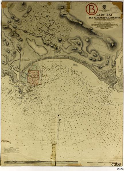
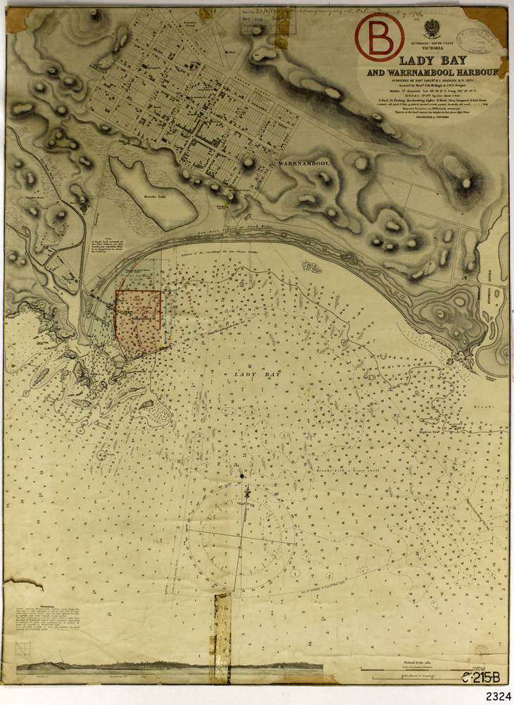
This navigation cart of Lady Bay and Warrnambool Harbour was originally surveyed in 1870 but this version includes the update for magnetic variation in 1893.
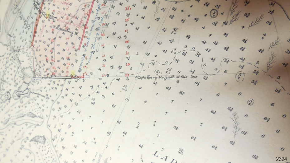
Since the printing of the chart several annotations have been added. These include an additional stamp dated 15-8-1910, a handwritten comment across the top of the page dated August 1910, and another handwritten comment regarding the ‘Proposed Extension of Dock’ dated 19-2-1925, plus connected drawings, notes and figures.
The 1925 proposal on this chart may have been a reaction to the Royal Commission of 1923, when the damaged stonework on the seaward side of the Warrnambool Breakwater, caused by the action of the sea, was the subject of enquiry. A conference between the Public Works, Water Commission and the Harbour Trust concluded that it would less costly to make repairs to prevent further damage rather than replaced the damage portion of the wall. A contract was raised in late 1924 to deposit rubble on the damaged side of the breakwater to minimise the Southern Ocean’s destructive action and work had started by August 1925.
The Breakwater construction had begun in 1874 and was completed in 1890. The Victorian Government had commissioned Sir John Coode, a British harbour engineer, to present a plan to complete the Warrnambool Breakwater but his original plan was too expensive. He prepared a revised plan for a shorter structure. The construction proved to be too short to protect adequately from the weather and didn't allow enough depth for larger vessels to come into port. The decreasing trade was further affected by siltation in the bay due to the breakwater, and the completion of the railway line.
The situation of the harbour became a real problem by 1910 and required continuous dredging. In 1914 the Breakwater was extended but proved to be a failure because the work began to subside and by 1920 about two thirds of the harbour was silted up. Alterations made in the 1920's increased the silting problem and by the 1940's the harbour was no longer used. More alterations were made in the 1950's and 1960's.
Significance
This chart is significant for its strong connection to the maritime history of Warrnambool Harbour and Lady Bay and the Warrnambool Breakwater. The Warrnambool Breakwater is registered as a place of significance on the Victorian Heritage Database (VHR H2024).
The Warrnambool Breakwater is one of the most important late 19th century maritime engineering projects in Victoria and significant in the development of Victorian coastal shipping. It is also significant for its connection with British harbour engineer, Sir John Coode.
The chart is a historical record of structures existing in 1893; the Warrnambool Jetties, Warrnambool Breakwater in Lady Bay, the leading lights (lighthouses), streets, roads, bridges and many buildings. It also shows the lay of the land and seabed.
Physical description
Navigation Chart: Lady Bay and Warrnambool Harbour, Australia - South Coast - Victoria.
Surveyed by Nav. Lieut. H.J. Stanley, R.N., 1870. Updated for Magnetic Variation, 1893.
The rectangular chart is printed on heavy cream paper. Stamps are shaped rectangular, oval and round.
Around the Breakwater and Jetty area are handwritten notes, dotted and joined lines, numbers and signatures, and shading of red and green.
The chart shows the surrounds of Warrnambool Harbour, Lady Bay, the Breakwater and Jetty, roads, bridges and the streets in Warrnambool. It has sounding details, and angles of line from the leading lights.
Inscriptions & markings
Stamp, rectangular, including "AUG 1910"
Stamp, double oval " - - - -CHART"
Stamp, hand drawn, red circle, with "B" inside
Hand written note "22-8-1910 - - - - - of surveying C. Ca - - - request of 15-8-10 [initials] "
Notes and lines in red pen, including a grid of sounding numbers: "1300" "1050" "1200" "Possible Extension of Dock" "19-2-25" "Dock Dredged to 20 Ft"
Notes and lines in blue pen "Extension of Dock to accommodate vessels drawing 20 Feet" and "Light not visible south of this line"
Red dots (4) with yellow highlight at both leading lights, breakwater and jetty
Subjects
- flagstaff hill,
- warrnambool,
- flagstaff hill maritime museum & village,
- maritime museum,
- maritime village,
- shipwreck coast,
- map,
- chart,
- navigation chart,
- plan,
- lady bay,
- warrnambool harbour,
- port of warrnambool,
- breakwater,
- jetty,
- pier,
- dock extension,
- proposed extension,
- vhr h2024,
- 1870,
- 1893,
- 1910,
- 1925,
- warrnambool town late 1800s,
- warrnambool streets late 1800s royal commission,
- 1923,
- public works,
- water commission,
- harbour trust,
- victorian harbours,
- sir jon coode
References
- VHD Warrnambool Breakwater, Viaduct and Harbour Victorian Heritage Database
- Warrnambool City Council – Warrnambool Breakwater
- The Age - Warrnambool Breakwater, Repairs being effected The Age, 16 April 1925, p.8