Showing 856 items matching "surveyors"
-
 Bendigo Historical Society Inc.
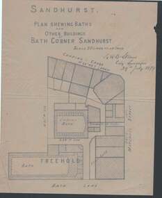
Document - PLAN OF BATH CORNER: SANDHURST 1879
Buff coloured plan showing Baths and other buildings at Bath Corner Sandhurst. Scale 50 Links to an Inch. Plan area Charing Cross, Mitchell Street and Bath Lane. Plan has bearings on it. Signed by G R B Steane, City Surveyor, 29th July 1879.place, building, commercial, plan of bath corner sandhurst 1879, charing cross, ladies' bath, g r b steane -
 Glen Eira Historical Society
Article - COANE, JOHN MONTGOMERY
... Surveyors ...This file contains one item about Coane and his family: 1/A one page extract from The Australian Dictionary of Biography Vol. 8 page 35 on John Montgomery Coane, Surveyor and Consulting Engineer, his partnership with George Hudson and later when his two sons joined the business. It details many of the projects he designed for rural Victoria and New South Wales and his other areas including Consulting to The Pacific Phosphate Co. Ltd of London and to the City of Brighton where he lived.coane john montgomery, blacker’s orchard & cannery co., victorian institute of surveyors, county donegal, ireland, mordialloc, ballyshannon, mines department sludge abatement board, coane henry edward, surveyors, engineers, land surveyors board, coane henry james, j.m. and h.e. coane, coane jane nee montgomery, coane john montgomery junior, victorian education department, australian roads, collas emma anna hunt, books, grant george hudson, coutie b.m., state electricity of victoria, melbourne, epsom racecourse, racecourses, brighton, city of brighton, brighton re-adaptation society, brighton cemetery, cemeteries, southern roger j, australian dictionary of biography vol. 8, early settlers -
 Orbost & District Historical Society
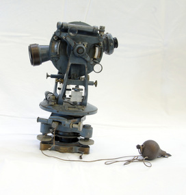
theodolite, first half 20th century
Theodolites have been used to measure horizontal and vertical angles by surveyors since the 1500s. A theodolite is a precision instrument for measuring angles in the horizontal and vertical planes. Theodolites are used mainly for surveying applications, and have been adapted for specialized purposes in fields like meteorology and rocket launch technology. Theodolites, such as this one, were instrumental to early surveyors, and would have played a significant part in their everyday work. The plumb bob was used to set the instrument exactly over a fixed survey marker.This theodolite was made by Troughton and Simms, who were significant scientific instrument makers of the 19th century and early 20th century. In 1782 John Troughton purchased Benjamin Cole's shop in Fleet Street, London enabling him to sell his own signed products. His instrument making business supported several dynasties of Troughtons before becoming Troughton and Simms and later still Cooke Troughton & Simms. This firm was one of the most well respected firms of instrument makers of the 1800s. A grey metal theodolite - probably made of brass. It has movable parts and there is a weight ( a plumb bob) attached with string.Cooke Troughton & Simms Yorke England V012318 Supplied by A. E. Parsons Melbournetheodolite scientific-instruments surveying -
 Orbost & District Historical Society
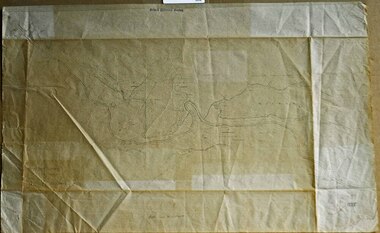
survey sheet, circa 1870's
E.L. Bruce, born in Ireland on July 1,1854, came to Australia in 1854 and joined the Lands Department. He spent most of his service in Gippsland. The journey to Sale then was made by ship to Port Albert and thence on horseback. He began his service in Gippsland as assistant district surveyor and for the last 12 years before retirement he was district surveyor and land officer. His territory extended from the boundary of Victoria in east Gippsland down to Wilson's Promontory with his headquarters at sale.This map is a useful reference tool.A survey map - Sheet No 3 SnowyRiver Survey. This is a copy of the original survey. It shows the properties of W.J.T. Clarke - two in Orbost and one in Newmeralla (sic),. it has a faded, undecipherable red stamp in the bottom right corner.Gipps Land Rivers No 32B E.L. Brucesurvey bruce-e.l snowy-river-c19th -
 Bendigo Historical Society Inc.
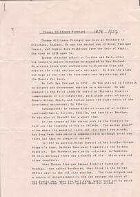
Document - RESEARCH PAPERS: THOMAS WILKINSON PINNIGER, 1828
Thomas Pinniger (1828-1927) was born in England and emigrated to New Zealand before coming to Australia in 1852. With a team of 4 he conducted the first geodetic* survey of Victoria. He became the Government Surveyor for Bendigo in 1853 and in 1854 he laid out the plans for the town of Broadford. His son George, became the Victorian Surveyor General 1925-6. * Large scale mapping based on global measurements of large land masses. It allows corrections for the curvature of the earth.Document detailing the history of district serveyor Thomas Wilkinson Pinniger and his family history. -
![Survey metal tape on reel with leather bag. 10 yards in length, the metal chain is subdivided every 10 links [2.2 yards].](/media/collectors/4f729f7e97f83e03086018d1/items/5f87f8fd13cca91a6c1db65a/item-media/615a8287eb51660bb8dc9e31/item-fit-380x285.jpg) Queenscliffe Maritime Museum
Queenscliffe Maritime MuseumInstrument - Survey tape on metal reel in leather bag with other articles
A surveyors chain is actually a thin steel band on a reel and is used for accurate measurements. This 110 yard [101m] chain is subdivided every 10 links [2.2 yards or 2m]Items belonged to J P Larkin Government marine surveyor who worked on surveys up to 1938. He worked in Port Phillip and Queenscliff related surveys [e.g. Western channel, Queenscliff channel].Survey tape on metal reel in leather bag with other articles: plumb bobs, number pegs, drawing instruments in box and steel punchesMade by A.E. Parsons surveying instruments, 215 Queen Street Melbournesurveying equipment, j p larkin -
 Melton City Libraries
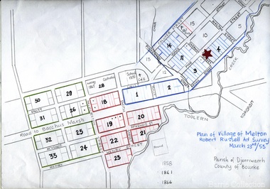
Map, Plan for the Village of Melton, 1853
Site of early village Section numbers 1 - 17 Later became the Flat known as the Common Robert Russell – Surveyor Pinkerton, Sherwin, Bryan, Pyke, Yuille, CollyerMelton Town 1853 Plancouncil -
 Eltham District Historical Society Inc
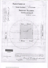
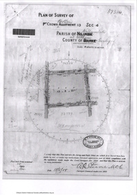
Document - Photocopy, Survey Fleld Notes of Part of Crown Portion 12, Section 4 at Eltham, Parish of Nillumbik, County of Evelyn, 20 May 1911
Portion of land bounded by: Main Road, York Street, Bible Street, Bridge Street Application 38629 Frederick Dudley Smith, M.C.E. Licensed Surveyor, 20 May 1911application 38629, bible street, bridge street, eltham, main road, map, survey plan, york street -
 Eltham District Historical Society Inc
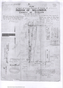
Survey Fleld Notes of Part of Crown Portion 13, Section 4 at Eltham, Parish of Nillumbik, County of Evelyn, 17 May 1926
Portion of land bounded by: Eltham Railway Station, Main Road, Luck Street, Arthur Street Application 4182/215 J.T. Robinson, Licensed Surveyor, 17 May 1926application 4182/215, arthur street, eltham, eltham railway station, luck street, main road, map, survey plan -
 Greensborough Historical Society
Plan, Plan of Manatunga Circuit Greensborough subdivision, 1970_
Plan of Manatunga Circuit subdivision. Prepared by O'Connor and Beveridge (land surveyors) for Development Underwriting (developers). Plan of subdivision. Part of Crown Portion 3. Parish of Nillumbik, County of Evelyn.An original example of a subdivision plan in the expanding suburb of Greensborough. The 1960s and 1970s saw this area develop from a rural farming area to a suburb.Plan of subdivision. Printed on buff paper, hand coloured. Mounted on cardboard. Includes 2 small cards attached.Various handwritten comments. Small cards from Survey Branch, Office of Titles.greensborough, manatunga circuit, diamond creek road, plenty river drive -
 Lakes Entrance Historical Society
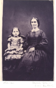
Photograph, Sarah and Marion Elizabeth Grant, 1863 c
In 1863 George Grant, Surveyor Assistant, wife Sarah and family were living at Reeves River Lakes Entrance camped below. Marion Elizabeth Grant married James HowlettBlack and white photograph of Sarah Grant nee Batten and daughter Marion Elizabeth taken at unknown location Victoria. Plus two other photos of Marion Grant genealogy, families -
 Frankston RSL Sub Branch
Compass, Plane Table
A plane table compass as used by surveyors and artillery crew complete with a protective wooden transit case. This compass is the type used by artillery units of the Australian Military Forces during World War 2. This compass was manufactured by J. W. Handley P/L of Melbourne in 1943. Refer 00330.1 and 00330.2 -
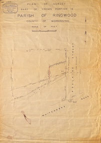 Ringwood and District Historical Society
Map, Plan of Survey, Part of CP12, Adelaide Street, Ringwood, Circa 1920s
Undated map of part of commercial area in Parish of Ringwood, County of Mornington showing Adelaide Street, Whitehorse Road, and un-named laneway behind Whitehorse Road shops marked as Road, and New Road Alignment. Made by H.J. Macey, Licensed Surveyor 36 Narissa Street Burwood BX1917. -
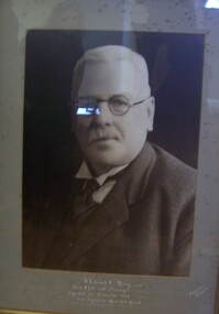 Glenelg Shire Council Cultural Collection
Photograph - Photograph - J. Edward C. Henry, Arthur & Sons, Mt. Gambier, c. 1938
Portland Town CouncilBlack and white photograph of a man with white hair parted on left and a moustache. He is wearing round glasses and a dark suit with white shirt (peaked collar) and dark tie. Mounted in grey matt, under glass in wooden frame.Front: J. Edward C. Henry, Town Clerk and Surveyor Appointed 20th November 1888, over 50 years an officer of the Council (white paint, lower centre). -
Port Melbourne Historical & Preservation Society
Plan - Fencng, Sandridge, Engineering Department, Borough of Sandridge, 1879
Design for fencing Block 19 (bounded by Lyons Street, Liardet Street and Esplanade West), Borough of Sandridge, 1879Signed by R Gabell (7-4-1879) and Chas. Clay, Surveyor (15-3-1879) and E. Clark, Town Clerk (14-4-1879):"Contract No. 355"engineering - fences, edward clark, town clerks, charles clay, r gabell -
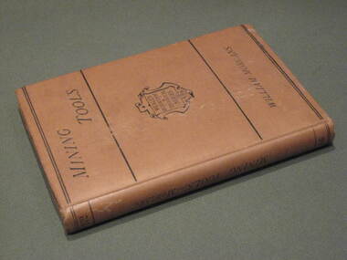 Federation University Historical Collection
Book, Manual of Mining Tools, 1871, 1871
The author, William Morgans, was a lecturer on mining at the Bristol School of Mines. The owner of the book, William Baragwanath, was a former student of the Ballarat School of Mines who held the following positions: Department of Mines (1897-1922); director of the geological survey (1922-24); chief mining surveyor (1924-32); secretary for mines (1932-34); chief mining surveyor (1934-43); consultant to the Department of Mines (1943-50); President, Royal Society of Victoria (1943-44), councillor of the Ballarat School of Mines (1916-50).Hard cover book of 207 pages with buff cloth cover. The books covers materials andf processes used in the manufacture of tools, special uses, qualities and efficiciency. It includes 235 wood engravings of mining tools drawn to scale. Tools include borers, hammers, sledges, picks, shovels, spades, saws, helves and handles.Title page handwritten in ink 'W.B.' [William Baragwanath]mining, tools, ballarat school of mines, geology, bristol school of mines, government geologist, william baragwanath -
 Orbost & District Historical Society
plans, June 15 1931
The Rising Sun Reef first opened, at Bonang in 1868.– at Goongerah Creek south west of Bonang. William Hunter (1893-1971), resident of Tatura and Mallacoota was a soldier, surveyor and amateur naturalist. This document is a useful research tool.Plans and application for the "Rising Sun Goldmine". Tery are on foolscap sized white paper with black text. hunter-william gold-mining rising-sun-goldmine bonang -
 Eltham District Historical Society Inc
Document - Photocopy, Survey Fleld Notes of Part of Crown Portion 13, Section 4 at Eltham, Parish of Nillumbik, County of Evelyn, 18 May 1908
Portion of land bounded by: Main Road, Luck Street, Bible Street, Arthur Street Application 37314 W. P. Steane, M.C.E. Civil Engineer and Surveyor, 18 May 1908application 37314, arthur street, bible street, eltham, luck street, main road, map, survey plan -
 Queenscliffe Maritime Museum
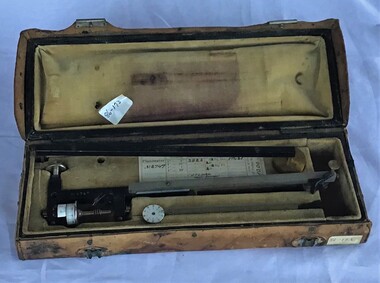
Instrument - Planimeter in leather box
This planimeter in leather box was used by P. J. Larkin, government surveyor, for measuring irregular areas in plans and charts. This type of instrument is still used today and is useful for computing dredging volumes.Surveyor active in the 20s and 30s in Port Phillip and QuennscliffA Planimeter in its own leather box.The Adams Engineering Co. Wellington N.Z. No 8747surveying instruments, p j larkin -
![Plan, Surveyor's Street Plan of Melbourne 1837 [copy], 1837_](/media/collectors/4f729f5697f83e03086015b8/items/534ccbc12162ef06c8d2cbf7/item-media/58afbfe2d0ce1616fcdf244b/item-fit-380x285.jpg) Greensborough Historical Society
Greensborough Historical SocietyPlan, Surveyor's Street Plan of Melbourne 1837 [copy], 1837_
Copy of Surveyor's Street Plan of Melbourne 1837. Donated by Patsy Coverdale and accompanied by brief details of her family connection to the map. Copies of plan available for sale from Greensborough Historical Society.Map of early Melbourne with connections to a current resident.Copy of plan, mounted on timber and framed.melbourne street plan, coverdaye, umpleby -
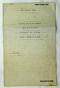
 Warrnambool and District Historical Society Inc.
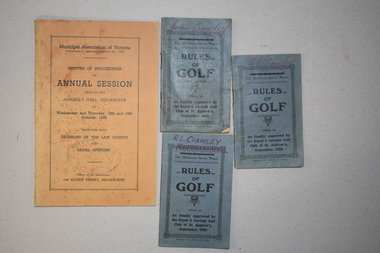
Publication, Wild & Beissel Pty Ltd, Booklet, 1939
One of these booklets contains the Minutes of Procedure of the Annual Session of the Municipal Association of Victoria in October 1939. The other three items are booklets containing the rules of golf as approved by the Golf Club of St Andrews in 1920. The four items belonged to Rolf Crawley who had a private surveying, engineering and architects practice in Warrnambool and was also the engineer for the Shire of Warrnambool from 1935 to 1968. The Shire of Warrnambool existed from 1863 to 1994. Rolf Crawley’s grandfather, father and uncle were also engineers and worked in that capacity or as the Shire Secretary for the Shire of Warrnambool, with the Crawley family recording a total of 132 years of service to the Shire. The items came into the possession of Michael Hand who took over the private surveying business of Rolf Crawley in Warrnambool. The Warrnambool and District Historical Society acquired the items, along with several ledgers and other Crawley memorabilia, from the estate of Michael Hand. These booklets are of minor interest as items that belonged to Rolf Crawley, the engineer for the Shire of Warrnambool in the mid 20th century..1 This is a buff-coloured booklet of 121 pages. It has printed matter and one black and white photograph. It has two mauve stamps on the front cover and on the first page. .2.3.4 These are three small identical booklets with blue covers. They each contain 48 pages and have black and white advertisements. They have handwritten names on the front covers. .1 ‘Rolf L. Crawley Civil Engineer, Drainage and Water Supply Engineer, Licensed Surveyor, Registered Architect, Warrnambool’ .2.3.4. ‘Rolf L. Crawley Warrnambool’ ‘Nettie Crawley’ rolf crawley, warrnambool, shire of warrnambool -
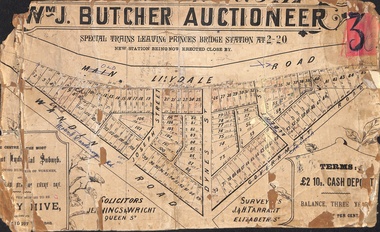 Ringwood and District Historical Society
Poster - Land Sale, Wm J. Butcher, Auctioneer - Albert Park Estate, Ringwood - c.1890
Central section of land sale subdivision advertisement glued to heavy cardboard backing. Photocopied SLV image of original advertisement shows map of 117 allotments for sale in Main Lilydale Road (later Old Lilydale Road), Wandin Road (later Mount Dandenong Road), Joseph Street, Dynes Street, Albert Street (later Wyrunga Street) and Government Road (later Carcoola Road), Ringwood East.Solicitors - Jenningw & Wright, Queen Street. Surveyors - J.&H. Tarrant, Elizabeth Street. Terms £2 10s cash deposit, balance three years at six per cent. -
University of Melbourne, Burnley Campus Archives
Plan - Photocopy, Proposed Reserve for Horticultural and Experimental Garden in the Survey Paddock Richmond, 1862-1948
Photocopy of Plan Gazetted 01.08.1863. From Central Plan Office Department of Natural Resources.Original signed by Clement Hodgkinson, Deputy Surveyor General. Stamped Department of Lands and Survey 7.12.48 Neg.18377. Handwritten notes on back "Melb Roll 23, R.19(A)"burnley, horticultural and experimental garden, survey paddock, richmond, clement hodgkinson -
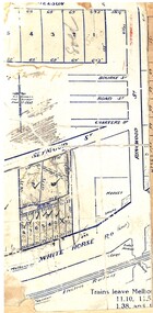 Ringwood and District Historical Society
Map, Partially trimmed copy of a retail and residential auction advertisement, Ringwood, Vic. - 1926
One of 3 unrelated land subdivision maps on cardboard backing. Numbered allotments on Nelson Street, Seymour Street and Whitehorse Road, Ringwood.W.J. Bonwick, Licensed Surveyor, Phone WU4830. Location map also includes Bourke Street, Bond Street, Charter Street, Ringwood Street, and Shops and Market sites in Ringwood. -
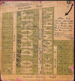 Ringwood and District Historical Society
Map, Residential Subdivision Allotment Layout on Mullum Mullum Road, Hobart Street, Paxton Street, Arnold Street and Warrandyte Road, Ringwood, Vic. (Undated, circa 1920)
Map on cardboard backing clipped from Subdivision Plan 7578 - Part of Crown Allotment 32, Parish of Warrandyte, County of Evelyn.H.C. Crouch, Licensed Surveyor, 443 Lt Collins Street, Melbourne. Includes handwritten real estate sales notations and Certificate of Title reference - Vol 3922 Fol 784242. -
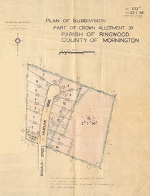 Ringwood and District Historical Society
Map - Plan of Subdivision, Part of Crown Allotment 39, Parish of Ringwood, County of Mornington - 1968
Map showing residential allotments numbered 1 to 14 Headline Court, Heathmont, Victoria, off Bronaldi Street and Yallamba Place. Adjoining lot 15 marked as 2 acres 3 roods 29.8 perches with house and garage.Paul Millar & Associates, Land & Engineering Surveyors, First Floor, 14A Main Street Croydon (Phone) 723 4493. Ref. 232B Date 23.1.68 Amended 12.3.68 & 1.12.71. -
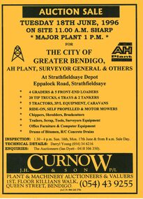 Bendigo Historical Society Inc.
Document - IAN DYETT COLLECTION: AUCTION CATALOGUE - THE CITY OF GREATER BENDIGO
Bright yellow auction catalogue with black printing for a sale on 18th June, 1996 for the City of Greater Bendigo, AH Plant, Surveyor General & Others at Strathfieldsaye Depot, Strathfieldsaye. For sale were Earth moving equipment, tractors, 3 P/L equipment, caravans, various mowers, chippers,shredders, brush cutters, trailers, scrap, tools, Surveyors equipment, office furniture & computer equipment, drums of bitumen and R/C concrete drains. J. H. Curnow & Son P/L were the auctioneers. Map of how to get to auction site inside front cover. Loose pink Supplementary List, account Coliban Water listing backhoe/F.E. loaders, tractor, tipper crane and 4WD wagon listed.business, auctioneers, j h curnow & son pty ltd, ian dyett collection - auction catalogue - the city of greater bendigo, ah plant, surveyor general & others, darryl young, ian dyett, j h curnow & son p/l, coliban water, noel dyett, fred dyett -
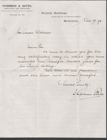 Bendigo Historical Society Inc.
Document - W.D.MASON COLLECTION: LETTER, 17 November08
Cream Document, W.D.Mason Collection, Letter from Hyndman & Bates,Architects and Surveyors Corner Collins and Swanston Streets, Melbourne, dated 17.11.(18)98 to Mr Owen Williams - we have to thank you for the very satisfactory way in which you have executed the simple leaded glass for Mrs. Craig's Cottage.business, retail, w d mason -
Kew Historical Society Inc
Archive (Sub-series) - Subject File, Kew Historical Society, HODDLE Survey, 1997
Various partiesReference, Research, InformationSecondary Values (KHS Imposed Order)Photocopied correspondence and maps (surveys) relating to surveys ordered by Robert Hoddle, Government Surveyor. Authors of letters and information include Gwen McWilliam and Jack Hackett. Much of the correspondence relates to the site of the ‘Hoddle Tree’, currently located in the Kew Golf Course. Jack Hackett’s original map is contained in the map drawers in the Society’s archive.kew historical society - archives, kew (vic) - history, robert hoddle - surveyor, hoddle tree - kew (vic), jack hackettkew historical society - archives, kew (vic) - history, robert hoddle - surveyor, hoddle tree - kew (vic), jack hackett -
 Bendigo Historical Society Inc.
Document - LANDS OFFICE - PLANS FORWARDED TO CROWN LANDS OFFICE, 1.9.1871 to 5.4.1880
Document: hard cover journal, brown cover with darker tan spine. 239 pages. Contains index at front of journal. Listings of plans forwarded to Melbourne Crown Lands Office by Bendigo Office. Alphabetical listing in front followed by numbered pages with individual details. Parish, county, allotment, section, surveyor, date remarks.Lands Officelands office, sandhurst, bendigo, land sales, land surveyed, plans