Showing 91537 items matching "tambo-shire-history"
-
 Lakes Entrance Historical Society
Photograph, Lakes Post Newspaper, Metung Singers Metung Victoria, 1994
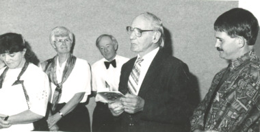
entertaining at Tambo Shire Offices Open Day Tambo VictoriaBlack and white photograph of Metung Singers with poet Len Martin and Cr. Barry Secombentertainment, people, choir -
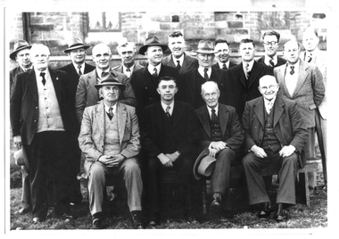
 Pyrenees Shire Council
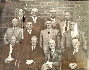
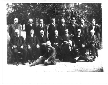
Photograph, Shire of Lexton Councillors and Officers, 1958
significant to the Pyrenees Shire and Lexton communityFramed Photograph of Shire of Lexton Councillors and Officers 1957-8 "Inscribed front: Shire of Lexton Councillors & Officers 1957-1958" -
 Lakes Entrance Historical Society
Book, Fletcher, Meredith and Kennett, Linda, East Gippsland Shire Council Thematic Environmental History, 2001
A thematic study concerning the interaction between people and the diverse environment of what is now the East Gippsland Shire, formed in 1994 by the amalgamation of the Shires of East Gippsland, The study encompasses the years since first European contatownship, transport, government -
Tatura Irrigation & Wartime Camps Museum
Book, Ardmona Cricket Club History - The Premiership Years, 2011
History of Ardmona Cricket Club premiership years 1959/60, 1960/61, 1961/62. Photocopies of items from local papers and players details. See also L0712 - 0718 for photographs, reunion and CD of reunion etc.A4 46 page history of Ardmona Cricket Club Ardmona Sport 1950-60's. History of Ardmona.ardmona cricket club, cricket clubs of victoria -
 Greensborough Historical Society
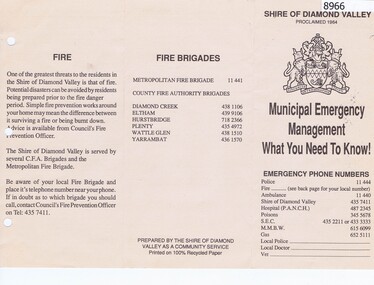
Pamphlet, Municipal Emergency Management: what you need to know: Shire of Diamond Valley, 1990c
Shire of Diamond Valley Municipal Emergency Management pamphlet with emergency phone numbers and procedures. Circa 1990s.Pamphlet 2 sided printed on cream paper, text only.shire of diamond vallety, emergency services -
 Greensborough Historical Society
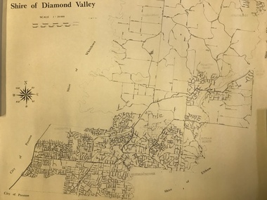
Map, Shire of Diamond Valley, 1964-1994
Map of the former Shire of Diamond Valley, 1964-1994, showing the local government area from Greensborough to Hurstbridge.Map on yellowed paper.shire of diamond valley, greensborough, hurstbridge -
 Greensborough Historical Society
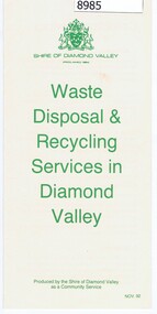
Pamphlet - Pamphlet and document, Shire of Diamond Valley, Waste Disposal & Recycling Services in Diamond Valley, 01/02/1992
Shire of Diamond Valley Pamphlet and letter to Householders regarding the Kerbside Recycling Collection Services being implemented in 1993.Pamphlet, folder printed in green on buff paper; Letter to Householders, black text on white paper.shire of diamond vallety, recycling, waste management -
 Eltham District Historical Society Inc
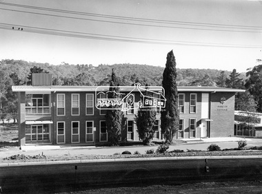
Photograph, Eltham Shire Office, shortly after duplication of Main Road, c.1968
Eltham Shire Council office built 1964 on the former site of Shillinglaw Cottage. In 1971 the offices were extended with a southern wing (to the left of the building) which housed the Eltham Library and planning offices. Taken shortly after widening of Main Road between Pitt Street and Elsa Court which was undertaken between February 1968 and August 1968. Image was most probably commissioned by Eltham Shire Council and taken by Hugh Fisher, photographer who operated from premises between Arthur and Dudely streets and was often contracted by the shire for official photographic work. The image was used in the August 1971 issue of Australian Municipal Journal This photo forms part of a collection of photographs gathered by the Shire of Eltham for their centenary project book,"Pioneers and Painters: 100 years of the Shire of Eltham" by Alan Marshall (1971). The collection of over 500 images is held in partnership between Eltham District Historical Society and Yarra Plenty Regional Library (Eltham Library) and is now formally known as the 'Shire of Eltham Pioneers Photograph Collection'. It is significant in being the first community sourced collection representing the places and people of the Shire's first one hundred years.Digital image and 120 format B&W negativesepp, shire of eltham pioneers photograph collection, eltham, main road, duplication, road widening, shillinglaw trees, local government -
Phillip Island and District Historical Society Inc.
Book, BRADLEY, David, Within the plains of paradise : a brief social history of Rhyll, Phillip Island, 1997
History of RhyllStamped 'Phillip Island & District Historical Society'. Signed by the authors, November 1997.phillip island, victoria, description, travel, rhyll, history -
 Mont De Lancey
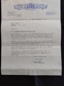
Document - Shire of Lillydale: Planning Application, Shire of Lillydale, 12th September, 1974
Vintage legal documents for land division in Victoria, especially those predating the Torrens system (October 1862), are often found in the Public Record Office Victoria (PROV). These documents, like deeds and Crown grants, can help trace the history of land ownership and division. A letter from K.H. Scott, Shire Engineer of the Shire of Lillydale Victoria to M. H. Proctor Re: Planning Application P.S./833. It is typed on the blue elaborately printed Shire letterhead and dated 12th September, 1974. The application from Mr Proctor to subdivide land situated and described as C.C. 12 Sec B Queens Road., Wandin was granted. Conditions apply.Signed 'Yours faithfully K H Scott K.H. Scott Shire Engineer' 'In reply please quote 1832:74 MGE:DW'legal documents, contracts, documents, indentures -
 Tarnagulla History Archive
Photograph of group of men, probably Shire of Bet Bet Council, circa 1920s, circa 1920s
Murray Comrie Collection. This photograph taken after the amalgamation with the Borough of Tarnagulla Council in 1915. Middle row, fourth from left is Walter (Wattie) Corrie, the Tarnagulla Baker, fourth from left is James Duggan, Tarnagulla Agent. Shire of Bet Bet Proclaimed Sept 20, 1864 Re-defined Feb 10, 1891 Tarnagulla Borough united Oct 1915 Dunolly Borough united Nov 1, 1921 Re subdivision from 5 to 3 ridings Oct 1952Monochrome photograph of a group of men assembled in rows for a photograph. No caption or explanation accompanies photograph. Probably depicts members of the Shire of Bet Bet Council in the 1920s. Location and names unknown. Walter Martin is sitting in the middle of the middle row. He was the Tarnagulla baker at the time of the photo. To the right of him in the photo is James Duggan, Tarnagulla dealer and agent. tarnagulla, council, bet bet shire, local government, councillors, mayor, shire -
 Warrnambool and District Historical Society Inc.
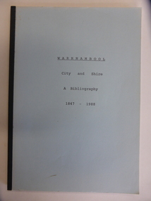
Booklet, City & Shire Bibliography 1847-1988, 1989
This 1989 booklet contains lists of publications connected with Warrnambool and District and it was compiled by W. Pinson and M. Johnstone. The publications listed were ones held at the time by the Warrnambool branch of the Corangamite Regional Library Service and the Warrnambool Institute of Advanced Education library. The publications are listed under the headings of Community, Environment, Heritage, Industry and Tourism. Although the information in this book is well out-of-date, it may be of interest to researchers today. The publications may still be available at the Warrnambool Library or at the South West College of TAFE in Timor Street Warrnambool or at Deakin University in Warrnambool. This is a soft cover booklet of 162 pages. It has a pale blue cover and is bound with black tape. It has a map of Warrnambool city, an Introduction, an alphabetical listing of publications concerning Warrnambool City and Shire and an Index. It has some photocopied black and white photographs of Warrnambool (untitled) and a reproduction of the front cover of Osburne’s History of Warrnambool.Front Cover: ‘Warrnambool City and Shire’ ‘A Bibliography 1847-1988’ history of warrnambool, history of western district, warrnambool library -
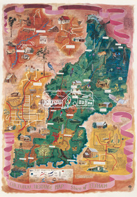
 Marysville & District Historical Society
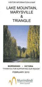
Map (Item) - Tourist map, Murrindindi Shire Council, VISITOR INFORMATION & MAP LAKE MOUNTAIN, MARYSVILLE & TRIANGLE, 02-2010
A visitor information map for Lake Mountain, Marysville and the local district produced by the Murrindindi Shire Council in February 2010. This information guide and map was produced after the 2009 Black Saturday bushfires destroyed most of the township of Marysville.A visitor information map for Lake Mountain, Marysville and the local district produced by the Murrindindi Shire Council in February 2010.Murrindindi Shire Council has made every effort to ensure the information provided at the time/ of printing is correct, but accepts no responsibility for an inaccuracies or omissions.lake mountain, marysville, victoria, australia, visitor information & map, murrindindi shire council, big 4 holiday park taggerty, black spur inn, black spur motel & caravan park, bush creek buddha, buxton hotel motel, cathedral valley farm, chestnut glade, crossways historic country inn, delderfield luxury b&b, kingbilli country estate, marapana agistment park & farm stay b&b, maryton park b&b, pinjarra gardens, sarsens rest, silverstream b&b, tower motel, willowbank at taggerty, wombat cottage, woodlands rainforest retreat, buxton general store and post office, buxton zoo nursery, cathedral view natural therapies, country touch, cross country ski hire, foodworks, highwood health retreat, lake mountain ski hire, lit & beyond, lj hooker, maroondah outdoor equipment/bait & tackle, marysville medical centre, marysville patisserie, marysville ski centre, marysville triangle real estate, marysville visitor information centre, mystic mountains ski hire/outdoors, pat's hairdressing, penni lanes country wares, plant's by shelian -
 Greensborough Historical Society
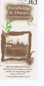
Pamphlet, Hurstbridge and District Local History Group, 2006c
This brochure details the purpose and activities of the Hurstbridge and District Local History Group. Operating out of Allwood Neighbourhood House, the Group offers a range of local history activities and access to the Hurstbridge collection.Tri-fold A4 sheet of buff paper, printed in brown with sepia illustrations.hurstbridge, allwood neighbourhood house, hurstbridge and district local history group -
 City of Greater Bendigo - Civic Collection
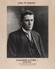
Photograph - Portrait of Alexander Guthrie, Alexander Guthrie / Secretary / Shire of Marong
c 1934 Commemorative mounted black and white portrait of Alexander Guthrie to remember his twenty eight years of service to the Shire of Marong.Shire of Marong / Alexander Guthrie ESQ / shire of marong, city of greater bendigo portraits, alexander guthrie -
 Eltham District Historical Society Inc
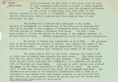
Document - Appendix, M.B. Watson, Shire Secretary, List of Former Road Board Chairmen and Shire Presidents (1856-1966), 28 Nov 1966
Appendix to Shire Secretary’s Report, 28 November 1966 SHIRE PRESIDENTS Local Government in this part of the State could be said to have commenced with election in 1846 of three trustees for "The Parish Road, leading from the Suburban Allotments in the Parish of Jika Jika, near Melbourne, to the Village Reserve in the Parish of Nillumbik". The Upper Heidelberg and Old Eltham Road follow approximately the original line of road proclaimed in 1840. The Eltham Road District was proclaimed on 24.9.1856. A meeting of landowners and householders of the Eltham Road District was held on 14.10.1856 at the Fountain of Friendship Hotel, Little Eltham, for the purpose of forming a District Road Board. To date I have been unable to locate any record of the names of the members elected, or of the first Chairman. Further research may yield the desired information. The Shire of Eltham was constituted on 28.3.1871. The proposed Roll of Shire Presidents should, I believe, also include the Road Board Chairmen. It may also be considered fitting to recognise the Heidelberg or Nillumbik (or Warringal) Road Trust in the same way. The first Minute Book of the Board, covering the period 1856 to 1863, has apparently been missing for many years. The Shire Minute Book for the period 1878 to 1885 is also missing. The absence of these vital records makes difficult the compilation of a complete and accurate list of Chairmen and Presidents. Although an early letter book yielded the names of the Shire Presidents in 1878, 1879 and 1800. The names prior to 1863 were derived from Rate Books and Government Gazettes. The information contained in the Municipal Directories 1875 to 1885 is at variance to some extent with such Council records as are available for that period, and consequently cannot be relied upon for the years where the Presidents names have not been shown. shire of eltham archives, series listing, a. armstrong, a. beale, a. brinkkotter, a. donaldson, a.h. price, a.j. braid, c.h. bath, c.m.a. pelling (mrs.), c.t. bell, d.c. o'beirne, e.d. butler, e.h. cameron, e.j. andrew, e.p. harmer, f.e. griffith, f.v. squire, f.w. nankervis, g. love, g. robertson, h. dendy, h. hewitt, h. stooke, l.t. wilmot, j. cox, j. murray, j. barr, j. bell, j. fitch, j. herbert, j. lawrey, j. mealy, j. pape, j. ryan, j. smedley, j.b. shallard, j.l. beale, l. c. docksey, r. mcadam, r.a. bell, r.c. white, r.r. woolcott, rutter, s.s. addison, s.w. scott, t. armstrong, t. irvine, w. horris, w. hubbard, w. lorimer, w. morris, w. taylor, w.c. farrell, w.f. ford, w.g. gray, w.h. bradbury, w.j. taylor, w.v. houghton -
 Greensborough Historical Society
Book, Nick Vine Hall, Tracing your family history in Australia: a guide to sources. 2nd ed, 1994_
A guide to family history/genealogy sources in Australia. 657p.genealogy resources -
 Orbost & District Historical Society
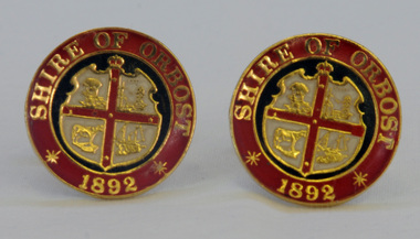
cuff links, 1992
This pair of cuff links was produced in 1992 as a memento/souvenir to commemorate the centenary of the formation of the Shire of Orbost - 1892-1992. Orbost was at first included in the Bairnsdale Shire from 1882 and was later part of the Tambo Shire. Because of travelling distances the Croajingalong Shire was created in 1892 (name changed to Orbost Shire 17.2.1893 with James Cameron as the first Shire President. In 1994 it amalgamated to become part of East Gippsland Shire Council.A pair of gold-plated and enamel cuff links embossed with the Shire of Orbost Coat of Arms and the year of inauguration.Shire of August 1892cuff-links souvenir memento orbost-shire-council -
 Greensborough Historical Society
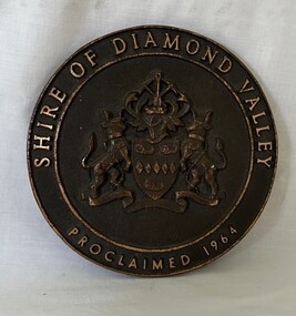
Plaque, Shire of Diamond Valley, Shire of Diamond Valley, Proclaimed 1964 Plaque, 1960s
This Logo was from the front door of the original Diamond Valley Library under Shire of Diamond Valley offices, Civic Ave, Greensborough. This was before the current Diamond Valley branch was built.Round brass plaque with writing and logoshire of diamond valley, plaques, diamond valley library -
 Tarnagulla History Archive
Photograph of Shire of Bet Bet Council, 1952, Shire of Bet Bet Council, 1952, 1952
Murray Comrie Collection. Shire of Bet Bet Proclaimed Sept 20, 1864 Re-defined Feb 10, 1891 Tarnagulla Borough united Oct 1915 Dunolly Borough united Nov 1, 1921 Re subdivision from 5 to 3 ridings Oct 1952Monochrome photograph of a group of men assembled in rows for a photograph. Accompanied by a handwritten note (catalogued separately as a Research Note) with subjects' names. Names of subjects from accompanying note (handwriting difficult to decipher) are believed to be: Left to Right Back/3rd row: Cr J. Grogan, A. Whitehead, G. Barman, J.B. Reid, I.R. Stevens (?), KAG Lowe (Shire Sec), Mr A Rescott (Maryborough Advertiser) Middle row: Crs N.K. Conera (Pres. Elect), D.E. Wood, A. Brownbill, J.P. Mason, D. Clark, K.R. Culleton (Shire Engineer). Front/1st row: Crs G. Fotheringham, J. Fremantle (1951-52), A. Green, J. Hickey. Note also states: 'Secretary Lowe passed away Sept 7, 1952' and 'Fotheringham House, Glenferrie' (location where photograph taken?)tarnagulla, council, bet bet shire, local government, councillors, mayor, shire, engineer, maryborough advertiser, reid, grogan, whitehead, barman, stevens, lowe, rescott, conera, wood, brownbill, mason, clark, culleton, fotheringham, fremantle, green, hickey -
 Eltham District Historical Society Inc
Audio - Audio Recording, Audio Recording; 2018-06-13 Jim Connor and the history of the former Shire of Eltham office site, 13 Jun 2018
June Meeting (Newsletter No. 240, Jun. 2018) Prior to Shillinglaw Cottage (c1878-80) being relocated to where it is now operated as a popular cafe near the Eltham Library, it was within Josiah Holloway’s 1850s subdivision known as Little Eltham, which later became the centre of the first Eltham township. Originally a farmer’s cottage it is historically significant because it is one of the Shire’s oldest dwellings and a fine example of the work of the well-known pioneer builder George Stebbing. In 1964 the then Shire of Eltham purchased the Shillinglaw property with the intention of demolishing the cottage and constructing new Shire offices on the site. However extensive community action resulted in funds being raised to have the building saved and relocated further south to the Eltham Common, where it was joined by the Eltham Library 1994. New Shire offices opened in 1965, but following municipal restructure in 1994 these were demolished and the land sold to a developer, which precipitated a dramatic trail of community angst, threats of legal action, the sacking of a newly elected council and several unsuccessful development proposals, by subsequent councils. After all these years the vacant site there is still guarded by the three trees that were outside the front of the Shillinglaw Cottage. At our Society meeting on Wednesday 13th June 2018 Jim Connor will speak about the dramatic tale encompassing the history of the former Eltham Shire office site and the adjoining War Memorial Buildings complex, which are now being considered for sale or redevelopment by the current Nillumbik Shire Council.1:17:57 duration Digital MP3 File 27 MB audio recording, eltham district historical society, jim connor, meeting, shire of eltham office site, society meeting -
Glenelg Shire Council Cultural Collection
Book, Glenelg Shire, 150 Years in the Making, 2014
a) Book, Glenelg Shire, 150 Years in the Making. Produced by Glenelg Shire Council, launched July 2014. Card cover, views of early Portland front and back covers, sepia tones, Glenelg Shire logo on front. Black print, black and white and coloured photographs. Signed on the fly-leaf by the then premier of Victoria, Denis Napthine. 'Congrats to Glenelg Shire 150 years in the Making. Well done, Denis Napthine PREMIER July 2014' b) Envelope for the booklocal history, history of the glenelg shire, victoria, denis napthine -
Tatura Irrigation & Wartime Camps Museum
Book, Girgarre Living History, Girgarre. Girgarre Living History, 2016
Girgarre - an extraordinary history, closer settlement, soldier settlement and family stories.Tells of the history of Girgarre, with information obtained from a collection of stories and extensive research into the Closer and Soldier Settlement of the districtRectangular shaped book ,aerial photo of the township and environs of Girgarre, on Market Day, September 2013. Photo extends over front & back covers, highly colourful cover. 251 pages. B/W photos and maps of local families and local scenes.girgarre, family histories, soldier settlement -
Tatura Irrigation & Wartime Camps Museum
Book, Girgarre Living History, Girgarre. Girgarre Living History, 2016
Girgarre - an extraordinary history, closer settlement, soldier settlement and family stories.Tells of the history of Girgarre, with information obtained from a collection of stories and extensive research into the Closer and Soldier Settlement of the districtRectangular shaped book ,aerial photo of the township and environs of Girgarre,on Market Day, September 2013. Photo extends over front & back covers, highly colourful cover. 251 pages ,B/W photos and maps of local families and local scenes.girgarre, family histories -
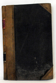 Orbost & District Historical Society
cash book, 1905 - 1914
This ledger was used by the Shire of Orbost pound keeper from 1906 - 1914. The item was donated to Orbost & District Historical society from P.R.O.V. as a Place of Deposit (POD) item for safe keeping by a local history group or museum. The shire covered an area of 9,347 square kilometres and existed from 1892 until 1994 when it became part of the East Gippsland Shire Council. Orbost was at first included in the Bairnsdale Shire from 1882 and was later part of the Tambo Shire. Because of travelling distances the Croajingalong Shire was created in 1892 (name changed to Orbost Shire 17.2.1893 with James Cameron as the first Shire President. In 1994 it amalgamated to become part of East Gippsland Shire Council. This book records the impounding of animals which have been found wandering on local roads or trespassing on land. Many are farm animals. Impounded animals were either claimed by their owners after payment of a fee or if unclaimed , they were sold. The Orbost Pound was situated on Martin Street.This book is a record of a practice which was necessary to remove stock which were wandering on local roads or trespassing on neighbours. It contains many local names and is of social interest. (ref. Vic. Collections)A ledger with a black cover, brown binding. The page edges are marbled. It contains hand-written records of payments received by the treasurer of the Orbost Pound.on spine : inside a red box in gold lettering"Pound Cash Book" inside a black box in gold lettering"Shire of Orbost"orbost-shire-council orbost-pound accounts cash-book -
 Eltham District Historical Society Inc
Map (item), Megan Evans, Cultural Heritage Map, Shire of Eltham, 1993
Copy of artist's map of the Shire of Eltham with numerous historical and cultural places of interest illustrated and notated including evidence of original Wurundjeri occupation and local flora and fauna. The original watercolour is held in the Nillumbik Shire Council Civic Collection. "Evans remembers being surprised they had asked an artist to create this map rather than a designer. Originally made as a watercolour, the map was later made into posters and adorned many homes around the area. The map creatively interprets the town and provides a wayfinding to both cultural and historical points in the area." Nillumbik Arts News December 2023. artist, buildings, cultural heritage map, fauna, flora, map, megan evans, shire of eltham, wurundjeri -
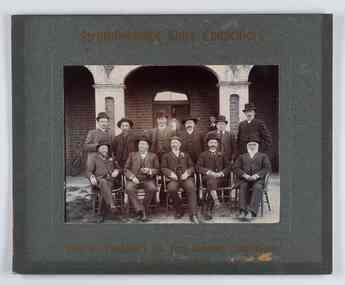 City of Greater Bendigo - Civic Collection
Photograph - Councillor group portrait, W H Robinson, Strathfieldsaye Shire Council, 1909
The district of Strathfieldsaye was proclaimed in 1861 and named a Shire on the 17th September in 1866. It remained a shire until amalgamation in 1994 when it became part of the City of Greater Bendigo. The shire was located 8 km to the south- east of Bendigo and covered an area of 601 square kilometres and extended from the Calder Highway to the Coliban and Campaspe Rivers. The shire's administration centre was in Strathfieldsaye until 1972 when new offices were opened in Kennington.Photographic group portrait of eleven Strathfieldsaye Shire Councillors in front of the Strathfieldsaye Shire Hall. Five men are seated and six standing with one man standing further in back ground on the building's verandah. Photograph is attached directly to green mount card and framed. Gold lettering on mount.Strathfieldsaye Shire Councillors / R. B. Brennan (Sec.) W. J. Lowdes S. Doak M. Burns () N Condon B. Code (Inspector) / WH Robinson Photo Bendigo / T Somerville / W. I. Long / Fred Osborne (President) H Keck / W Dresler / With the President's (Cr. Fred Osborne) Compliments / September 23rd, 1909shire of strathfieldsaye, strathfieldsaye shire council, president of strathfieldsaye shire, strathfieldsaye shire hall -
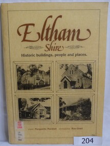 Greensborough Historical Society
Book, Eltham Shire: historic buildings, people and places, 1983_
The history of some of the Historic buildings in Eltham and the people who lived in them. Words by Marguerite Marshall, photographs by Ron Grant.This book discusses the identity of the Eltham area.Soft cover book with photographs of four Eltham buildings on front cover. 46pages, black and white illus. 3 copies.Copy 1: Withdrawn from Yarra Plenty Regional Library.eltham, kangaroo ground, marguerite marshall, ron grant -
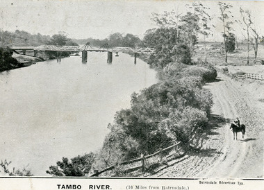 Lakes Entrance Historical Society
Postcard - Bridges, 1906
First timber road bridge over the Tambo River at Swan Reach officially opened 20 December 1905, after which punt was removed to BairnsdaleBlack and white postcard of the lifting bridge over the Tambo River at Swan Reach, Victoria. Man on horse standing on dirt road to Metung beside the river. Punt previously used to cross river visible against western bank of river.Tambo River (16 miles from Bairnsdale)bridges, waterways -
Lakes Entrance Historical Society
Book, East Gippsland Historical Society, The Growing of Hops in the Mitchell and Tambo Valleys, 1983
An account of hop growing industry in the Mitchell and Tambo Valleys, Gippsland, Victoria, from commencement c.1869 to the decline and demise in 1916. Includes biographical details of families in the industry, setting up of gardens, hop pickers.industrial