Showing 22936 items
matching the yarra
-
 Kew Historical Society Inc
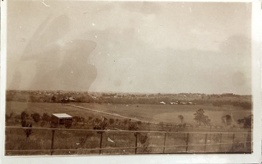
Photograph - Yarra Valley at Kew, 1918
During the nineteenth century, the land abutting the south side of the Yarra in Kew was devoted to dairy farming. In the twentieth century, before and after the construction of the Eastern Freeway, much of this low-lying area was used as golf courses and public parks.View of the farmland in the Yarra Valley at what is believed to be East Kew in 1918. Verso: "Willsmere / East Kew? / 1918"yarra river, yarra valley -
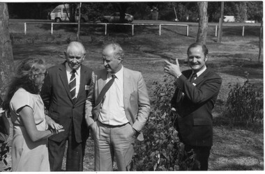
 Melbourne Legacy
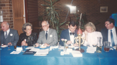
Photograph, Induction of Yarra Valley President 1989, 1989
Photos of a dinner to welcome the new president of the Yarra Valley Legacy Club's new president in 1989. Melbourne Legacy President Chas Wilks attended the induction (in the grey suit). Other names are not known.Representatives from Melbourne Legacy attended the important events of other Legacy clubs.Colour photo x 4 of the induction of the Yarra Valley's new president in 1989.legatee event, yarra valley branch -
 Greensborough Historical Society
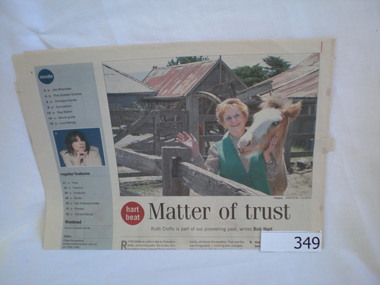
Newspaper clipping, Matter of Trust, 24/01/2004
Details the history of Gulf Station Yarra Glen and the Bell family from their time of arrival in Victoria in 1839.Origins of a pioneering family with some links to Greensborough.Newspaper article on the Gulf Station Yarra Glen and the Bell family. Includes text and photograph of Ruth Crofts.gulf station, charles la trobe, william bell, ruth crofts, bell family, happy hollow -
 Marysville & District Historical Society
Document (item) - Research Document, Judith Vimpani, Hermit of the Cumberland Goldfield-George Ernest Locke, 2020
An account of the life of George Ernest Locke who was a gold miner on the Yarra Track near Marysville in Victoria.An account of the life of George Ernest Locke who was a gold miner on the Yarra Track near Marysville in Victoria. George was a well-educated young man and had some success prospecting in the Cumberland area before partnering with William Chester with whom he opened the Golden Bower gold mine in 1896. George and William then discovered a second reef which they named the Silver Bower mine. George lived in a log cabin in the Cumberland reserve and was known to be a loner. He was clever with his money and chose not to have a bank account in Marysville, where everyone would learn about his financial status. He banked at the ES&A in Fitzroy and at the time of his death in 1941 he had accumulated the princely sum of three hundred and sixty pounds. George Locke was known as "the Hermit of Cumberland Valley" and lived in his humpy until his last few days during which he moved into a Forest Commission's patrol hut because his old humpy had started to fall to pieces. When George passed away at the age of 81 years he had not visited Marysville for over 14 years. george ernest locke, gold miner, gold mining, yarra track, william chester, golden bower mine, cumberland goldfield, silver bower mine, chesterville, marysville, victoria, jackie lewis, baron somers, big tree, picea sitchensis exotic, box hill cemetery, john edward locke, annie caroline locke, hermit of the cumberland valley -
 Kew Historical Society Inc
Photograph - Yarra in Flood, 1934
Flooding of the Yarra Valley, including that section of the Yarra bordering Kew and Kew East in the north and west of the municipality, was a regular occurrence. Extreme flood events of the Yarra River are recorded to have occurred in 1891, 1901, 1916, 1923 and 1934. The Municipality of Kew's response to these floods was to enact planning decisions restricting residential development in flood prone areas following the floods of 1916, 1921 and 1934. While floods continued after the development of the Upper Yarra Reservoir (construction 1948-57), the regularity and extent of these inundations diminished.Black and white print positive. 1934 floods of the Yarra Valley. Location Fairfield looking towards wooded hillside. Houses floating in river.Reverse: "From Fairfield Park (11936?) back towards hill (Wurundjeri Spur?)"floods -- 1934, yarra valley, yarra river, fairfield park -
Melbourne Tram Museum
Document, Dennis Cliche, Employee News, 25 October 2007
This page is a letter to all Yarra Trams employees following a tram on tram collision in Flemington Rd, North Melbourne. It outlines the media stories and expresses appreciation to all employees for their work in delivering safe transport.Yields example of public relations between CEO and staff and concern when staff and passenger safety is breached.One singled side A4 size page printed with black ink A Message from the Chief Executive Officer, Yarra Tramsyarra trams, collision, ceo, senior management -
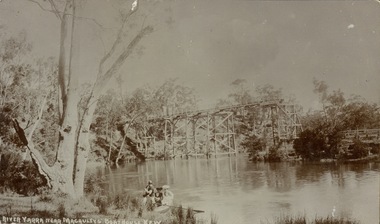
 Kew Historical Society Inc
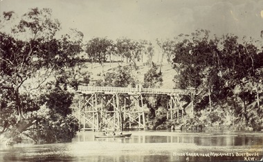
Postcard, J.W.K. & Co, River Yarra near Macauleys' Boathouse Kew, c.1910
The Zig-Zag Bridge which was constructed in the 1870s to link the Yarra Bend Asylum and Kew Asylum. Initially it transported bluestone from the west side of the Yarra to the east during the construction of the Kew Asylum.Real photo postcard of the Zig-Zag Bridge at Kew. In the middle ground there is a rowboat.Obverse: "River Yarra near Macauleys' Boathouse Kew". Reverse: "Gift from L Bennett"bridges -- river yarra, bridges - kew (vic.), zig-zag bridge -
 Kew Historical Society Inc
Photograph, Railway Viaduct, c.1900
Railway viaduct, Yarra River, linking Kew and Fairfield. Built by John Monash for the Outer Circle Railway. In 1930 converted into the Chandler Highway Bridge for vehicular traffic. Annotations on reverse: "KH-71. Outer Circle Railway Bridge (over Yarra) looking from Kew side to site of Paper Mills, Alphington.outer circle railway, railway viaduct (kew), john monash, chandler highway bridge -
 Kew Historical Society Inc
Photograph, Floods in North Kew, 1934
Living with natural processes was frequently a challenge to early European settlers and later residents of what was in the 1850s administered by the Borondara Road Board. This was compounded by the area being bounded on three sides by rivers (Yarra River, Koonung Creek and Gardiner's Creek). In 1849, the historian James Bonwick recorded that "our district [Kew] suffered considerably. Mr Wade speaks of 80 acres, out of 100 acres of his cultivated paddock, covered by water." Newspapers continued to describe major flooding in Kew in 1863, 1869, 1878, 1880, 1889, 1891, 1916 and 1934. While the construction of the Upper Yarra dam in 1957 reduced the levels of flowing downstream, local and riverine floods continue.The Kew Historical Society's pictures and map collections testify to the impact of flooding in the district. They have historical importance in documenting the extent of flooding in the district and its affects on homes, services and recreation. Numerous photographs record flooding throughout the Twentieth Century.Floods in North Kew, 1934. Unidentified location on the Yarra Flood Plain at Kew.floods (kew) 1934, yarra river -
 Kew Historical Society Inc
Photograph - Yarra Valley at Kew, 1912
During the nineteenth century, the land abutting the south side of the Yarra in Kew was devoted to dairy farming. In the twentieth century, before and after the construction of the Eastern Freeway, much of this low-lying area was used as golf courses and public parks.Real-photo postcard of the farmland in the Yarra Valley in what is believed to be North Kew in 1912. Verso: "Willsmere / East Kew / 1912"yarra river, yarra valley, farming -- kew (vic.) -
 Marysville & District Historical Society
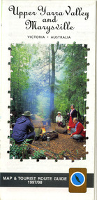
Map (Item) - Tourist map and guide, Warburton Ranges Tourism, Upper Yarra Valley and Marysville VICTORIA-AUSTRALIA, 1997
A tourist map and guide for the Upper Yarra Valley and Marysville produced by Warburton Ranges Tourism and Mystic Mountains Tourism in 1997.A tourist map and guide for the Upper Yarra Valley and Marysville produced by Warburton Ranges Tourism and Mystic Mountains Tourism in 1997.marysville, victoria, australia, tourist map, tourist guide, mystic mountains tourism, warburton ranges tourism, lake mountain, marysville post shop, the marysville museum, bruno's art and sculpture garden, marylands country house, blackwood cottages, dalrymples guest cottages, anastasia's cottage, marysville hotel motel, kerami guest house, the cumberland -
 Ringwood and District Historical Society
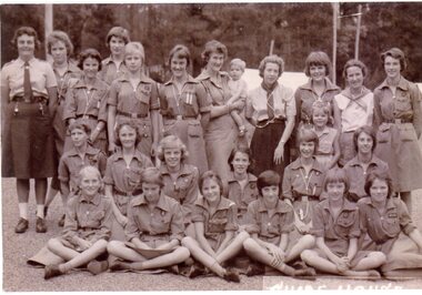
Photograph, Guide House, Yarra Junction- 1962
Photograph showing 1st Heathmont Guides at Guide House, Yarra Junction -1962"Written on back of photo" 1st Heathmont Guides -Guide House, Yarra Junction, 24/01/1962. Back Row: ?, ?, Jill Frame, ?, Kerry Fulton, Hazel Lauder, ?, Lorna Hamer, Avis Frame, Pam Crawford. Middle Row -all unknown. Front Row: ?, ?, ?, ?, Suzanne Cattermole, Marion McRae -
Whitehorse Historical Society Inc.
Mixed media - Audio Cassette, Talk - Water in the Eastern Suburbs, 12/04/2003
Cassette of a talk to the Society by David Elliott from Yarra Valley Water on the 'History of the Provision of Water in the Eastern Suburbs' on 12 April 2003.Cassette of a talk to the Society by David Elliott from Yarra Valley Water on the 'History of the Provision of Water in the Eastern Suburbs' on 12 April 2003.elliott, david, yarra valley water, water, nunawading & district historical society -
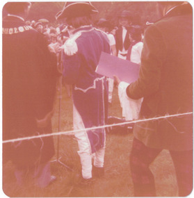
 Kew Historical Society Inc
Photograph - Historic re-enactment during the Festival of Kew, 1978
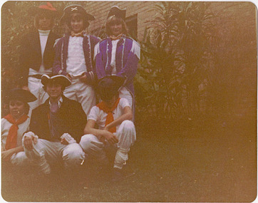
At the 1978 Festival of Kew, a number of organisations, including the City of Kew, the Kew Historical Society, Trinity Boys Grammar School and local Girl Guides participated in a re-enactment of the expedition of the party of Charles Grimes in surveying the Yarra River as far as Kew in February 1803. The location for the event was Yarra Bend Park near the Studley Park Boat House. The event was organised by the Kew Historical Society. The re-enactment was captured by a number of amateur photographers as well as by a photographer from the local Progress Press.Local communities select events to commemorate according to their shared history and values. Commemorations of colonial exploration were popular with local historical groups such as the Kew Historical Society in the twentieth century. In re-enacting events such as the Grimes survey of the Yarra, students from a local school were encouraged to take on specific roles, including play-acting individuals involved in the survey party as well as members of the local Wurundjeri People. The photographs, taken by amateur and professional photographers, represent a period in time when the dominant values were those shared by the descendants of European settlers in Victoria. Original colour photographic positive of six Trinity Grammar students, dressed in costume as members of the Charles Grimes survey of the Yarra of 1803.Annotated on reverse: "TRINITY GRAMMAR BOYS DRESSED AS GRIMES' PARTY DURING RE-ENACTMENT / K.H. SOCIETY'S CONTRIBUTION TO 1978 FESTIVAL / DONATED BY M. ROLLEY"kew historical society, trinity grammar school, kew girl guides, city of kew, yarra river, charles grimes, collins expedition, wurundjeri people, yarra bend park, colonial surveys, historic re-enactments, festival of kew, kew festival -
 Surrey Hills Historical Society Collection
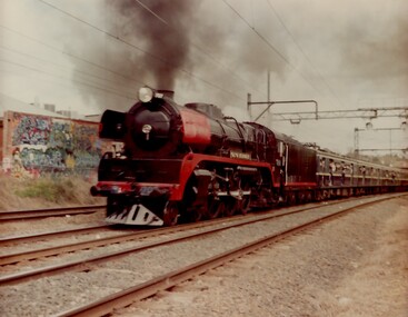
Photograph, Yarra Glen Special at Surrey Hills in 1986
Steam Rail Victoria is a Preservation Society which runs tour specials throughout Victoria. This particular train is being pulled by an R Class loco on a Yarra Glen Special. The carriages behind are Blue Harris carriages which were normally used on the electrified system. the train is approaching Surrey Hills from Chatham station.A coloured photograph of a Steam train blowing steam as it plows along pulling a number of blue carriages. There is some graffiti on the back of a building that backs onto the railway line.On back of photo: "A Yarra Glen Special / 1986 / At Surrey Hills"graffiti, surrey hills, steam trains, trains, 1986, harris carriages -
 Kew Historical Society Inc
Postcard, River Yarra near Macauleys' Boathouse Kew
Sepia postcard of the Zig-zaf Bridge joining Yarra Bend and Studley Park. In the foreground is a rowboat in which a man is standing, behind whom are two women in hats and a young child. The man appears to be pushing the boat away from the Bank. In the distance is the wooden Zig-Zag Bridge, constructed in the 1870s to link the Yarra Bend and Kew Lunatic Asylums. [Destroyed by flood, 1929.]Obverse: "River Yarra near Macauleys' Boathouse Kew". Reverse: "Zig Zag Bridge / Gift from L Bennett 1980 / Bridge between Old Asylum & new Mental Hosp. / Kew side"zig-zag bridge -- kew (vic.), bridges -- river yarra, bridges -- kew (vic.) -
 University of Melbourne, Burnley Campus Archives
Photograph - Black and white print, Minette Russell-Young Explaining Planned Revegetation of Yarra Bank, 1985
See "Green Grows Our Garden," A. P. Winzenried, for further details about the Yarra Revegetation Programme.Black and white photograph. Minette Russell-Young Explaining Planned Revegetation of Yarra Bank, talking to David Aldous (Principal Lecturer) and 2 visitors. Clyde Holding and ?david aldous, lecturer, clyde holding, minette russell-young, revegetation, yarra bank, vice-principal -
 Eltham District Historical Society Inc
Photograph, Doug Orford, Completion of bridge works across Yarra River at rear of Eltham Lower Park, July 2004
Bitumen shared pathway under construction at the new Eltham-Templestowe footbridge over the Yarra River off Homestead Road, Eltham which was completed in July 2004. The Yarra River Footbridge was opened in August 2004 and links the Diamond Creek Trail between the Shire of Nillumbik and City of Manningham. It is a shared pathway and also links with the Main Yarra Trail. It affords lovely views over the Yarra River.Three colour photographs showing commencement of construction of Eltham-Templestowe footbridge over Yarra River off Homestead Road, Eltham which was completed July 2004. Third photograph of dedictaion plaque at opening 30 Aug 2004bridges, yarra river, eltham south, eltham lower park, lenister farm, homestead road, asphaldt, bitumen, shared pathway, diamond creek trail -
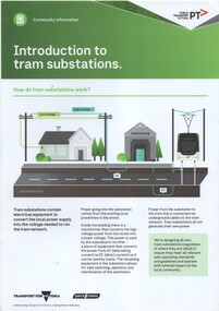 Melbourne Tram Museum
Pamphlet, Public Transport Victoria (PTV), Introduction to tram substations
Explains with diagrams how tram substations work. Published Transport for Victoria and Yarra Trams for Community Information purposes. Notes that currently (2019) trams substation were in use and that at least another 30 planned.Yields information on tramway substations for community information purposes.Pamphlet - printed on 200gms A4 card titled "Introduction to tram substations". Published by Public Transport Victoria and Yarra Trams 2019.yarra trams, substations, tramways, electrical engineering, consultation -
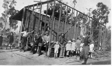 Upper Yarra Museum
Negative Photographic Reproduction, Warburton East, Primary School being demolished, 1988
Extract Local residents often had to provide their own school. These men with a little help from their offspring, are pulling down the Old East Warburton School to make way for a new one. Page 73, " The Upper Yarra An Illustrated History" by Brian Carroll, The Shire of Upper Yarra, 1988Warburton East, Primary School under construction Negative Black white Scanned at 600 dpi. Printed album presented to Upper Yarra Historical Society, compiled by R. Crowleyschool, east warburton -
Whitehorse Historical Society Inc.
Document, F. S. Baker/ Yarra Hill country map, 1950s
Advertising leaflet for F. S. Baker, Mt. Pleasant Road Nunawading,Advertising leaflet for F. S. Baker, Mt. Pleasant Road Nunawading, Real Estate Agent c. 1950s, backed by Broadbent's Map no. 280, Yarra Hill CountryAdvertising leaflet for F. S. Baker, Mt. Pleasant Road Nunawading, broadbents, baker, f. s., mount pleasant road, nunawading, no. 20 -
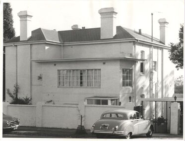 Kew Historical Society Inc
Photograph, 'Yarra Bluff', Redmond Street, c.1965
This work forms part of the collection assembled by the historian Dorothy Rogers, that was donated to the Kew Historical Society by her son John Rogers in 2015. The manuscripts, photographs, maps, and documents were sourced by her from both family and local collections or produced as references for her print publications. Many were directly used by Rogers in writing ‘Lovely Old Homes of Kew’ (1961) and 'A History of Kew' (1973), or the numerous articles on local history that she produced for suburban newspapers. Most of the photographs in the collection include detailed annotations in her hand. The Rogers Collection provides a comprehensive insight into the working habits of a historian in the 1960s and 1970s. Together it forms the largest privately-donated collection within the archives of the Kew Historical Society.'Yarra Bluffs' was the home of George Henry (1831-1906) and Allegra Charnock Mott (1831-1905), newspaper proprietor (and also a friend of John Inglis, father of Kew doctor, Edgar Inglis, who bought land adjacent to this property in the 1890s). Walter was a son who drowned in the Yarra in a swimming accident January 2, 1890. George & Allegra had fourteen children and the family continued newspaper publishing interests from 1853 until 1986, over four generations.' (Andrew Mott, 2015)[Annotation on reverse by Dorothy Rogers] "Walter Mott's house - formerly Yarra Bluff, Redmond St Kew. This was formerly the back entrance. It is now 2 flats. The upper is occupied by the present owner Mr. Tyler. Walter was drowned in the Yarra. He built the house about ____. He commenced the Kew Mercury in 188_. Back view of George Motts home (1890) Redmond Street".walter mott, yarra bluff, studley park, dorothy rogers -
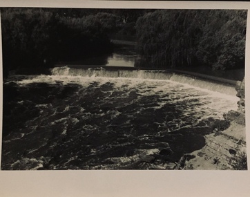 Kew Historical Society Inc
Photograph - Dight's Falls, 1920s
Dight’s Falls in Studley Park is an artificial weir built on a natural rock bar across the Yarra. The weir was built in the 1840s to provide water to the ‘Ceres’ flour-mill, one of the first in Victoria. The falls were later to become known as Dight’s Falls after the owners of the mill. Later, a pumping station was built on the Kew side of the river, which pumped water uphill to a reservoir in Walmer Street that provided water to the Melbourne Botanical Gardens and to Albert Park Lake. The area around Dight’s Falls was and is frequently used for recreational activities.One of a series of photographs, probably taken by Henry Christian of the Yarra River in Kew. An item from an outstanding and diverse photographic collection, assembled by members of the Christian and Washfold families of Kew.River Yarra at Dight’s Falls, Kew/Fairfield photographed from Kew bank.dight's falls, river yarra, christian-washfold collection -
University of Melbourne, Burnley Campus Archives
Photograph, James Leslie Provan, Burnley 1942 Album Page 2, 1942-1943
View of Yarra River from Yarra Boulevard.yarra river, yarra boulevard, burnley, 1942, j.l. provan -
 Kew Historical Society Inc
Photograph - Historic re-enactment during the Festival of Kew, 1978
At the 1978 Festival of Kew, a number of organisations, including the City of Kew, the Kew Historical Society, Trinity Boys Grammar School and local Girl Guides participated in a re-enactment of the expedition of the party of Charles Grimes in surveying the Yarra River as far as Kew in February 1803. The location for the event was Yarra Bend Park near the Studley Park Boat House. The event was organised by the Kew Historical Society. The re-enactment was captured by a number of amateur photographers as well as by a photographer from the local Progress Press.Local communities select events to commemorate according to their shared history and values. Commemorations of colonial exploration were popular with local historical groups such as the Kew Historical Society in the twentieth century. In re-enacting events such as the Grimes survey of the Yarra, students from a local school were encouraged to take on specific roles, including play-acting individuals involved in the survey party as well as members of the local Wurundjeri People. The photographs, taken by amateur and professional photographers, represent a period in time when the dominant values were those shared by the descendants of European settlers in Victoria. Original colour photographic positive of a Trinity Grammar School student in period costume reciting the report of his survey of the Yarra at the 1978 Kew Festival. . Annotated on reverse: "GRIMES GIVING A REPORT OF HIS JOURNEY / BACK VIEW"kew historical society, trinity grammar school, kew girl guides, city of kew, yarra river, charles grimes, collins expedition, wurundjeri people, yarra bend park, colonial surveys, historic re-enactments, festival of kew, kew festival -
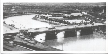
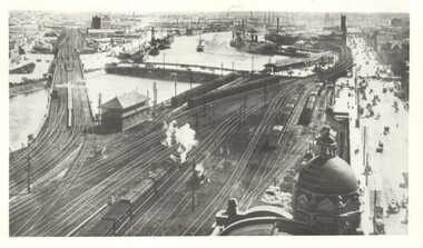 Melbourne Tram Museum
Photograph - Yarra River from Flinders St Station clock tower, Town and Country Journal, 1909
Photos show the Yarra river and the shipping turning basin that was used prior to the construction of the Spencer St bridge. In the view are are steam hauled suburban trains, Flinders St A signal box, Queensbridge, and the wharves on either side of the river. The viaduct was expanded to four tracks in 1915. Yields information about Yarra River, Flinders St railway station yards and shipping,Set of two photographs looking west from the Flinders St Station clocktower. over the Yarra River and station yards.On rear of both prints in ink: 1 – Melbourne - West from clock tower on Flinders St station - “Town and Country Journal 21/7/1909” Copy neg Mark Plummer collections ex late John Alfred collection. .2 - Melbourne, Looking west along Flinders St from clocktower of Flinders St station. Copy neg Mark Plummer collections ex late John Alfred collection. Has “T&C 20/12/09” in pencil on rear. bridges, flinders st station, yarra river, wharves, railways, signal boxes, queens bridge, shipping -
Whitehorse Historical Society Inc.
Article, Manufacturer a driving domestic force during war, 2004
Obituary of Ren Turner, horticulturist and manufacturer.Obituary of Ren Turner, horticulturist and manufacturer. His company, Turner Manufacturing Company made the distinctive Turner screwdrivers. He also developed the Yarra Farm Bulb Company.Obituary of Ren Turner, horticulturist and manufacturer. turner, rene, turner manufacturing co., yarra farm bulb company -
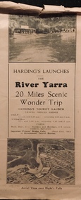 Kew Historical Society Inc
Flyer, Melbourne Ferries Pty Ltd, River Yarra: 20 Miles Scenic Wonder Trip
Bifold brochure including route map of the full 44 mile 'Wonder Trip' on pages 2 & 3. Photos used include an 'Aerial view over Dight's Falls', two ferries, and a 'Scene near Dight's Falls'.Flyer for Harding’s Launches on the River Yarra: 20 miles scenic wonder trip. Aerial view over Dight’s Falls on front. non-fictionBifold brochure including route map of the full 44 mile 'Wonder Trip' on pages 2 & 3. Photos used include an 'Aerial view over Dight's Falls', two ferries, and a 'Scene near Dight's Falls'.river yarra, melbourne ferries pty ltd, yarra river -- tourism, harding's cruises, christian-washfold collection -
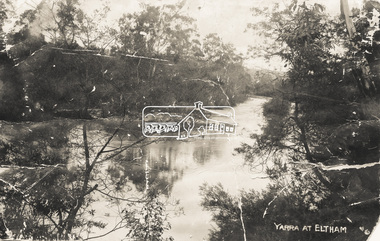 Eltham District Historical Society Inc
Photograph - Photo postcard, J.H. Clark, Yarra at Eltham, c.1910
This card depicts the Yarra River at Eltham circa 1910. It was addressed to "Mr J. L. Brown, "Elthamville", Tinning Street, Brunswick" most probably from an extended family member. From the same collection as accession no 00779, (Pond near Eltham Park) and no. 00780 (Eltham, J.H. Clark Photo - dated 20 May 1911). Sending postcards to family and friends including short messages was a common form of communication in the early 20th century. Photographer: J.H. Clark John Henry Clark was the youngest of three boys born to William Henry Clark (1823-1877) and Maria White (1843-1914). He and his brothers, William Charles Clark (1872-1945), Clement Kent Clark (1874-1912) operated a photography business (Clark Bros.) from 25 Thomas Street, Windsor near Prahran during the period c.1894 to 1914. Following death of Clement in September 1912 and their mother in 1914, the Clark Bros business appears to have dissolved, the premises demolished, and a new house was under construction in 1915. John set up business independently in 1914 operating out of 29 Moor Street, Fitzroy where he is registered in the 1914 and 1915 Electoral Rolls. By 1916 John had relocated to Eltham where he continued his practice as a photographer and took many of the early images around the district of Little Eltham. Around 1930 John changed professions and opened a small cobbler's shop in 1931 near the pond opposite Dalton Street adjacent to the Jarrold family cottage. He never married and continued his profession as a bootmaker from this little shop, maintaining a close relationship with Mrs Jarrold for the rest of their lives. His bootmaker shop remains today beside the Whitecloud cottage and is one of only three remaining shops in the area from the early 20th century. There are a couple of images of Eltham taken by Clark Bros. in the Eltham District Historical Society collection, one such example being Hunniford’s Post Office with Miss Anne Hunniford out front (EDHS_00140 - marked on the back of the print, Clark Bros., 25 Thomas St. Windsor), which would date this image between c.1894 and 1914. Other early images of Eltham taken by John Henry Clark are marked on the face “J. H. Clark Photo” and it is assumed these are dated between 1914 and 1930. It is noted that the Grant of Probate for John H Clark of Eltham South dated 5 April !957 (513/387) records his occupation as "X Photographer".Sending postcards to family and friends including short messages was a common form of communication in the early 20th century.Postcard in very poor condition which has been removed from an album. Glue residue and album page adhering preventing information being readFront: Yarra at Elthameltham, yarra river, brown family, j.h. clark photo -
 Melbourne Tram Museum
Photograph - Yarra River and Princes Bridge from Flinders St Station clock tower, Town and Country Journal, 1909
Photos show the Yarra river looking east over Princes Bridge. In both photos are cable trams, the rowing sheds and parts of Flinders St station. The first phtograph shows the nearly completed ramps from the platform, while the second has the former exit structure that allowed passengers to exit to Princes Bridge and St Kilda Road. Yields information about Yarra River, Flinders St railway station yards and Princes Bridge.Set of two photographs looking east from a Flinders St Station clocktower. over the Yarra River and Princes Bridge..1 – Melbourne Princes Bridge. Copy neg Mark Plummer collections ex late John Alfred collection. Has “T&C 20/12/09” in pencil on rear. .2 – Melbourne – Princes Bridge “Town and Country Journal 29/12/1909” Copy neg Mark Plummer collections ex late John Alfred collection.bridges, flinders st station, yarra river, railways, princes bridge, cable trams