Showing 2422 items
matching townships
-
 Orbost & District Historical Society
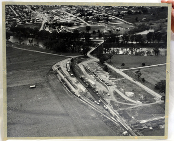
aerial photograph, 1970's
This photograph was taken prior to the closure of the Orbost -Bairnsdale freight line in 1987.The Orbost-Bairnsdale railway initially played a crucial role in developing agricultural industries in Gippsland as well as tourism. It opened in 1916 and operated until 1987, principally carrying timber and farming produce. In the early days of the railway's operation dedicated passenger trains ran but these ceased by the 1930s. The line was completely closed to freightage in 1987.The track infrastructure was dismantled in 1994 and has been redeveloped as the East Gippsland Rail Trail.A large black and white aerial photograph of Orbost Railway Station in the foreground and the Orbost township in the background. It has been pasted onto a piece of Masonite. railway photography orbost, railway photography orbost -
 Phillip Island and District Historical Society Inc.
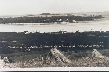
Photograph, Early 20th Century
One of 20 photographs/postcards donated by Mary KarneyBlack & White copy of postcard. View taken from San Remo overlooking township across the water to Newhaven, with Churchill Island and Rhyll in the background."Overlooking San Remo, Newhaven, Churchill Island; Rhyll in the distance. 285"san remo, newhaven phillip island, churchill island, rhyll phillip island, mary karney -
 Glenelg Shire Council Cultural Collection
Postcard - Postcard - Nelson, Victoria, n.d
Coloured photo postcard, aerial view of Nelson, Victoria, showing the bridge, township and river mouth. Rose Series De Luxe colorview NO 1213Back: Maker details. 'Aerial view of Nelson Victoria'postcard, nelson -
Glenelg Shire Council Cultural Collection
Certificate - Certificate - Syd Cuffe, Town Crier, 14/07/1997
Syd Cuffe was the Portland Town Crier from 1983 to 2013. The role of Town Crier was created for Syd Cuffe in 1983 in the lead up to Portland’s 150th anniversary celebrations held in 1984-85. 200 items from Mr. Cuffe’s estate were donated to the Glenelg Shire Cultural Collection. The items relate to his town crying activities and community work across the Shire and further afield.Certificate of welcome from township of Malden, to Syd Cuffe, July 14 1997. Grey card, black print, red and black seal of Malden. -
 Kiewa Valley Historical Society
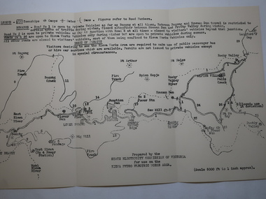
Map - Kiewa Hydro Electric Works Area
An early map of the Kiewa Hydro Electric Scheme Works Area prepared by the SECV for use when requesting access to the area. The regulations are printed regarding permits.During construction of the KHES there were restrictions on access to the area. This map identifies the land marks and states the regulations for entry to the area.Black and white map folded into three showing a legend with the townships, camps, gates and dams marked.Also indicating the roads, rivers, mountains and infrastructure of the KHES. khes works area, map of khes -
 Kiewa Valley Historical Society
Photos x53 - Ewan Stebbins Collection
Photos were digitized (instead of printed) onto CDs for preservation, easy storage and enabling multiple copies.These photos are a record of the early days of the Kiewa Hydro Electric Scheme including the town of Mt Beauty in the late 1940s to early 1950s Bronwyn Gray inherited these photos of Mt Beauty and the construction of the KHES. Her uncle Ewan Stebbins puchased a piece of furniture from a garage sale in Boston Rd., Torquay in 1981. The developed film were photos of Mt Beauty and surrounding area. He was an SEC employee and knew the area well.Case is hard plastic, black on the back and clear on the front. The 53 black and white photos are of Mt Beauty township and the Kiewa Hydro Electric Scheme. On the CD in black texta: "Mt Beauty / Film found in / furniture from house / in Boston Rd. / Torquay in 1981" Added in blue texta: "MTB 001 - MTB 053"mt beauty c1949, bogong c1949, stebbins photo collection -
 Ringwood and District Historical Society
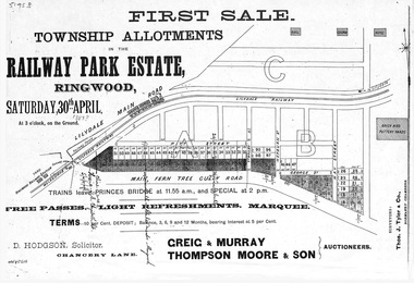
Flyer, Subdivision advertisement - Railway Park Estate, Ringwood, Victoria - circa 1887
Photocopy of advertisement for auction sale of township allotments in Railway Park Estate, Ringwood, on Saturday 30th April (1887?), with terms of sale and location map.Subdivision map includes Pitt Street and Main Ferntree Gully Road (later Bedford Road). (Agents) Greig & Murray, Thompson Moore & Son, Auctioneers. -
 Federation University Historical Collection
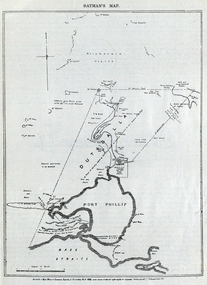
Image, Batman's Map of Port Phillip
Scanned from "The Old Pioneers' Memorial History of Melbourne From the Discovery of Port Phillip to the World War". It is a facsimile map from the House of Commons Reports of Committee.John Batman's map of Port Phillip showing Dutigalla (Batman's Tract), a township reserve, open plains, public common reserve, fresh water"A tract of country [called?] by the native chief of Southern Ausralia to be John Batman 6th June 1935."port phillip bay, john batman, melbourne, iramoo, r. sarsh, river sarsh, river batman, yarra river -
Lakes Entrance Regional Historical Society (operating as Lakes Entrance History Centre & Museum)
Book, Maddern I T, Shire of Rosedale Centenary 1871-1971, 1971
The history of the Rosedale Shire written for the centenary in 1971 includes history of the township schools churches cemetery and the original settlers who developed this region of Victoria.township, settlers -
Lakes Entrance Regional Historical Society (operating as Lakes Entrance History Centre & Museum)
Postcard, H D Bulmer, 1910 c
Black and white postcard taken from the hummocks looking across one of the low islands and the Snowy River showing view of the township of Marlo Victoriawaterways, jetties, boats and boating -
Clunes Museum
Photograph, KODAK, 1999
VIEW OF POWDER MAGAZINE USED IN MINING DAYS TO STORE EXPLOSIVES. BUILDING MATERIALS SOLID BRICKCOLOURED REPRINT PHOTOGRAPH OF POWDER MAGAZINE INTERIOR. SITUATED IN A PADOCK ON SMEATON ROAD APPROX. 2 KM. FROM TOWNSHIP ON LEFT HAND SIDE.local history, photographs, mining, powder magazine -
Clunes Museum
Negative - NEGATIVES, Mar-00
COLLECTION OF NEGATIVES -CLUNES TOWN HALL & COURT HOUSE, CLUNES HOSPITAL, CLUNES IN THE 60S, TOWNSHIP OF CLUNES FROM THE ROCKS , BUTTER FACTORY CLUNES.CLUNES BOROUGH COUNCIL ELECTED COUNCILLOR 28/8/1930.MAYOR 1934-35. HORNSBY STUDIO BALLARAT.photography, photography, negatives -
 Clunes Museum
Photograph, J. BAWDEN PHOTOGRAPHER STUDIO FRASER STREET, CLUNES, CIRCA 1890
TULLAROOP CREEK FROM "ROCKS" NEAR SITE OF PORT PHILLIP MINE. ABOUT 1890 - NOTE GOVERNMENT BRIDGE IN DISTANCE. THIS WAS REBUILT IN STRAIGHT STEEL GIRDERS IN 1896.ORIGINAL SEPIA PHOTOGRAPH OF TULLAROOP CREEK, IN FOREGROUND VIEWS OF CLUNES TOWNSHIP. TWO MILE HILL IN LEFT FAR DISTANCE. (SUSPENSION BRIDGE IN FOREGROUND)local history, photography, bridges - buildings and landscape of clunes -
 Lakes Entrance Regional Historical Society (operating as Lakes Entrance History Centre & Museum)
Photograph, 1960c
Copied from postcardColour photograph aerial view of the township, shows also Cunninghame Arm, the hummocks and distant view of Bullock Island and the entrance. Lakes Entrance Victoriaislands, jetties, memorials, hotels -
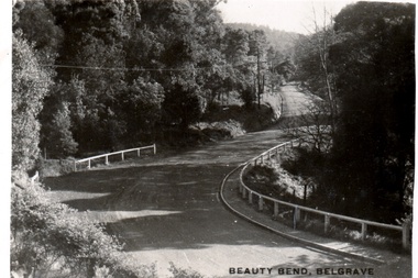 Southern Sherbrooke Historical Society Inc.
Postcard - Postcard-original-Beauty Bend, Belgrave, Vic. c. early 1930s, Beauty Bend
Sepia-toned postcard featuring Beauty Bend just outside Belgrave Township on Monbulk Road. There is heavy bush to either side. A house is in the distance. -
 Wodonga & District Historical Society Inc
Album - Hume Reservoir Australia Album - Workmen's Dwellings during Hume Reservoir construction, Department of Public Works, N.S.W, C. 1927
This set of photos is from a leather bound album bearing the inscription "HUME RESERVOIR AUSTRALIA" plus 'The Rt. Hon. L. C. M. S. Amery, P. C., M .P.' all inscribed in gold. It was presented to The Rt. Hon. L. C. M. S. Amery, P. C., M. P, Secretary of State for Dominion Affairs on the occasion of his visit to the Hume Reservoir on 2nd November 1927. This album is of local and national significance as it documents the planning and development of the Hume Reservoir up to 1927. It was the largest water reservoir in the British Empire. The album records the pioneering engineering work that went into its construction.DEPARTMENT OF PUBLIC WORKS, N.S.W. RIVER MURRAY WATERS SCHEME. HUME RESERVOIR. 8. Types of Workmen's Dwellings in the New South Wales Township. hume reservoir australia, river murray waters scheme, workmen's dwellings hume -
Lakes Entrance Regional Historical Society (operating as Lakes Entrance History Centre & Museum)
Postcard, 1908
Message on reverse: From Mabel at Tarnagulla to Zilpah Westerson at Clifcrest CunninghameBlack and white postcard showing buildings around shore line, ferry docked at business wharf , steam train around bay , township in distancetourism -
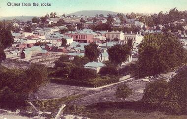 Clunes Museum
Postcard - PHOTOGRAPH, PRINTED IN GERMANY, CLUNES FROM THE ROCKS
COLOURED POSTCARD OF VIEW OF CLUNES - TAKEN FROM THE ROCKS CLUNES FROM THE ROCKS. COLOURED COPY OF PHOTOGRAPH OF CLUNES TOWNSHIP, SHOWING BANKS AND PUBLIC BUILDINGS IN FRASER STREET. PRINTED AS A POSTCARD. 3 COPIES759.2. DEAR ROD. WITH BEST LOVE TO YOU ALL FOR A MERRY XMAS AND A BRIGHT NEW YEAR HOPING YOU HAVE A GOOD TIME FROM AUNT MARIA.local history, document, postcard, clunes township -
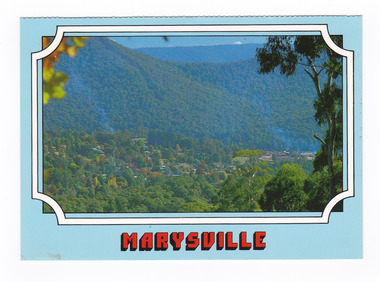
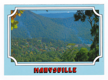 Marysville & District Historical Society
Postcard (item) - Colour postcard, Scancolor (Australia) Pty Ltd, Marysville, Pre 2009
A colour photograph of the view of Marysville from Cumberland lookout.A colour photograph of the view of Marysville from Cumberland lookout. This postcard was produced by Scancolor Australia as a souvenir of Marysville.MARYSVILLE Victoria - Australia View to Marysville township from Cumberland/ lookout. scancolor Australia (03) 555 1944 CS 4064marysville, cumberland lookout, victoria, scancolor australia, postcard, souvenir -
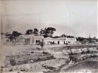 Pyrenees Shire Council
photograph, Untitled (Main thoroughfare through the township of Lexton ), c1880s
significant to the Pyrenees Shire and Lexton communityphotograph of Lexton streetscape "Throughfare through the township of Lexton in approx. 1880-1885 showing the Lexton Shop, Lexton Hotel and St. Mary's Anglican Church" -
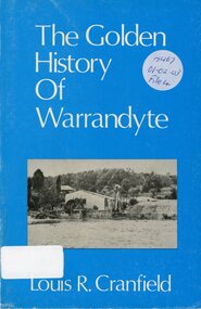 Ringwood and District Historical Society
Book, The Golden History of Warrandyte - Louis R. Cranfield
History of more than a 100 years from the earliest days of the discovery of gold and the setting up of a mining camp through to the transition of becoming a thriving township -
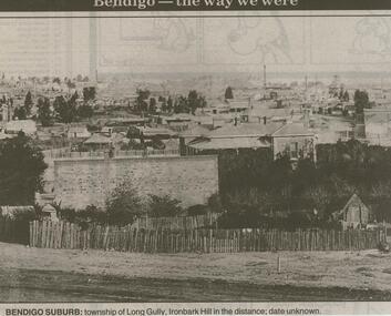 Bendigo Historical Society Inc.
Newspaper - JENNY FOLEY COLLECTION: BENDIGO SUBURB
Bendigo Advertiser ''The way we were'' from 2000. Bendigo suburb: township of Long Gully, Ironbark Hill in the distance; date unknown. The clip is in a folder.newspaper, bendigo advertiser, the way we were -
Bendigo Historical Society Inc.
Map - PROPOSED TOWNSHIP PARISH OF CAMPASPE, 24th May 1875
Map: Proposed Township, Parish of Campaspe(This has been crossed out and 'Creek View' written above). Hand Draughted Parish plan Stapled to the backingmap, township, proposed township, campaspe, creek view -
Clunes Museum
Map, FENTON CHARLES, 1987
TRANSPARENT PLASTIC SHEET WITH A MAP OF CLUNES TOWNSHIP DRAWN IN BLACK WITH TINY WHITE STICKERS DENOTING POINTS OF INTEREST, MOUNTED TO BROWN PAPER AND PINNED IN PLACE ON REVERSE OF BROWN PAPER WRITTEN IN BLACK IN "CLUNES 1987 TRACINGS"clunes 1987, clunes township map -
Tatura Irrigation & Wartime Camps Museum
Book, Warwick Finlay, The Doctor, The Captain, The Poet and Others, 2004
This book was printed to commemorate the 150th Anniversary of the survey, naming of the town and sale of land at Murchison.Black and white cover featuring the Goulburn River and portraits of Doctor McMillan, Captain John Murchison and Orion Horne over and early plan of Murchison Townshipmurchison -
 Victorian Aboriginal Corporation for Languages
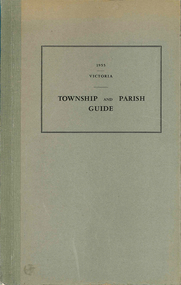
Book, Department of Crown Lands and Survey Victoria, Township and parish guide : Victoria, 1955
A alphabetical list of townships proclaimed under the Land Acts of Victoria. Shows the parish, land district and the municipality in which each is situated, and the particulars of Gazettal of Proclamation.victorian geographical names, victorian administration -
Lakes Entrance Regional Historical Society (operating as Lakes Entrance History Centre & Museum)
Postcard, 1915 c
Black and white postcard showing SS Gippsland in Cunninghame Arm opposite New Works houses and works buildings with township in background Lakes Entrance Victoriaships and shipping, jetties -
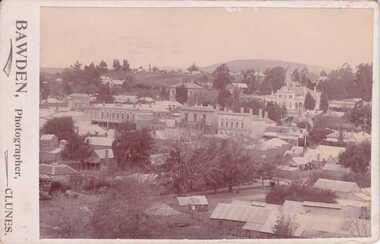 Clunes Museum
Photograph, BAWDEN - PHOTOGRAPHER, CLUNES, VICTORIA
SEPIA POSTCARD / PHOTOGRAPH - OVERVIEW OF CLUNES TOWNSHIP. S.S. BANK. CLUB HOTEL, POST OFFICE, TOWNHALL, WESLEY CHURCH AND TWO MILE HILL IN BACKGROUND.TO WISH YOU ALL GOOD CHRISTMAS BLESSINGS AND A HAPPY NEW YEAR. J. PATIENCE DEC. 1907.local history, photography, photographs, clunes township -
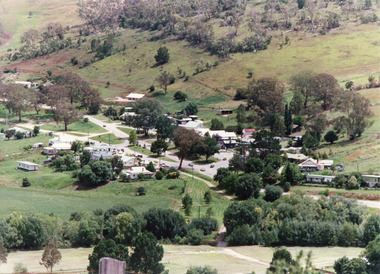 Lakes Entrance Regional Historical Society (operating as Lakes Entrance History Centre & Museum)
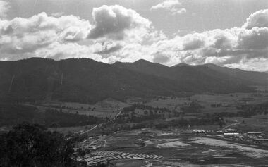
Photograph, Tambo Shire, 1994 c
Also second identical copyColour photograph of the township of Buchan, taken from a high point above the town which is situated in a valley with hills rising on all sides. Buchan Victoriawaterways, topography