Showing 112639 items
matching tracks/roads
-
 Phillip Island and District Historical Society Inc.
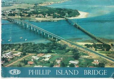
Booklet, Official Opening of the Phillip Island Bridge at San Remo 1969 and notes by the Bridge engineer, Tom Russell, 1969
... Country Roads Board ...Prior to 1939 access to the Island was by punt from San Remo or car ferry from Stony Point. A bridge was opened in 1940 but increased traffic and low load capacity was a problem. The decision to build a new bridge was made in the 1960s.HistoricalColoured, bound booklet with a photo of the old and new Phillip Island bridges on the cover and the CRB logo and name on rear. It includes the order of proceedings for the opening and bridge statistics, plans and contractor information. Also photos of construction and a history of travel to the Island before a bridge was built and the first bridge. There is also a 2 page typed document written by the bridge engineer who gives a brief history of access to the Island and problems at the opening with access and a rebel who tried to open it unofficially.Official Opening of the Phillip Island Bridge at San Remo by The Hon. M.V. Porter, MLA. Minister of Public Works. November 21 1969bridges, 2nd phillip island bridge construction, tom russell, phillip island bridge opening 1969 -
 Ringwood and District Historical Society
Pamphlets, Vic Roads, Pamphlets about Ringwood Bypass development, and one map. 1991-96, 1991-1996
... Vic Roads ...Pamphlets about Ringwood Bypass development. Qty 6. With one map. -
Clunes Museum
Book, NSW ROADS AND TRAFFIC AUTHORITY, ORAL HISTORY PROGRAM - A VITAL LINK THE EUSTON TO ROBINVALE MURRAY RIVER CROSSING, 2007
... NSW ROADS AND TRAFFIC AUTHORITY ...AN ORAL HISTORY PROJECT ABOUT A VITAL LINK BETWEEN EUSTON AND ROBINVALESPIRAL BOUND WITH IMAGES OF AN OLD IRON BRIDGE AND A NEW CONCRETE BRIDGE ON THE FRONT COVER DETAILING AN ORAL HISTORY PROJECT WITHIN THE TITLE OF THE BOOK. 81 PAGES AND AN ORAL HISTORY CD IS ATTACHED TO THE BACK PAGEnon-fictionAN ORAL HISTORY PROJECT ABOUT A VITAL LINK BETWEEN EUSTON AND ROBINVALEeuston to robinvale, river crossing, oral history -
 Eltham District Historical Society Inc
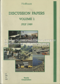
Book, VicRoads, Discussion Papers Volume 1, July 1989
... Roads...Roads Corporation ...VICROADS Discussion papers address key issues that have been identified by the community, through regional workshops, as having particular significance in determining the direction that should be taken in managing the rural arterial road system in Victoria to the year 2000. Volume One consists of the following discussion papers: road safety, rural development, conservation and the environment, future rural transport task and traffic in towns.non-fictionVICROADS Discussion papers address key issues that have been identified by the community, through regional workshops, as having particular significance in determining the direction that should be taken in managing the rural arterial road system in Victoria to the year 2000. Volume One consists of the following discussion papers: road safety, rural development, conservation and the environment, future rural transport task and traffic in towns.roads, vicroads, rural areas, road safety, rural development, conservation, traffic -
 Lakes Entrance Historical Society
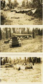
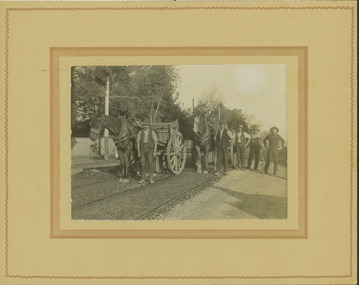
Photograph - Foundation piles for Swan Reach Bridge, Country Roads Board, 1925 c
... Country Roads Board ...Black and white photographs of preparation for construction of the Swan Reach bridge showing five large piles cut at the CRB timber coup at Won Wron South Gippsland Victoriabridges, construction, machinery -
 Kew Historical Society Inc
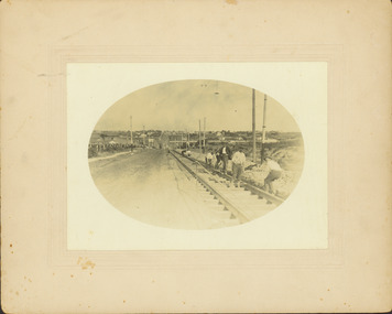
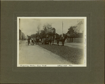
Photograph - Construction of the electric tram line in Riversdale Road, Surrey Hills, E.J. Dower, 1916
One of a series of photographs, taken by Edgar James Dower in the second decade of the twentieth century. Born and raised in Olinda, his family later moved to Surrey Hills. He worked as an adult as a clerk in the city office of the Metropolitan Gas Company, and in his role as a 'collector', he was able to photograph scenes including the construction of tramlines and associated buildings in Kew, Hawthorn, Camberwell and Surrey Hills. Later he established a real estate agency with his brother - the E.J. Dower Real Estate Agency, Dandenong Office.The image is an historically significant record of the development of transport infrastructure which was used to connect Victorians in the first two decades of the twentieth century. This development resulted from increases in population and the consequent extension of Melbourne's suburbs. The photographs, both individually and collectively, richly detail the labour of workers and the tools and machinery used to create and extend Melbourne's tram network in the years preceding and during World War 1.Digital copy of an original oval mounted photograph of the construction of the tracks for the new electric tramline in Riversdale Road, Surrey Hills. Annotated verso: "Preparing for electric tram line, Riversdale Road, Surrey Hills / Taken from near Warrigul [sic] Road / note Essex Road on right with picket fencing."theme --- travelling by tram, theme -- connecting victorians by transport and communications, trams -- boroondara (vic.), riversdale road -- surrey hills -
 Mt Dandenong & District Historical Society Inc.
Photograph, Farringdon Road
Mt Dandenong Road (CRB Road, New Road, Main Road) was begun in the early 1920s and completed c1926. This would be a very early photograph in the history of the road and shows a Jeeves coach travelling along the new road at the base of Farringdon Road in Kalorama. Ellis Jeeves established the coach sevice between Kalorama and Croydon in 1904. It originally travelled down the Old Coach Road. John Lundy-Clarke grew up in the Kalorama/Mt Dandenong area and later in life (1972-74) began to write a comprehensive history of the area working from an original settlement map in an effort to cover all areas.Black and white photograph looking down an unmade road showing a coach travelling along another unmade road at the bottom. Roads are tree lined. handwritten inscription on reverse by John Lundy-Clarke.1920 Farringdon Road, looking at Jeeves Coach on Mt Dandenong Road.mt dandenong road, crb road, farringdon road, jeeves, ellis jeeves, coach, mt dandenong tourist road, kalorama -
 Kew Historical Society Inc
Photograph - Electric tram line construction in Cotham Road, Kew, E.J. Dower, 1913
One of a series of photographs, taken by Edgar James Dower in the second decade of the twentieth century. Born and raised in Olinda, his family later moved to Surrey Hills. He worked as an adult as a clerk in the city office of the Metropolitan Gas Company, and in his role as a 'collector', he was able to photograph scenes including the construction of tramlines and associated buildings in Kew, Hawthorn, Camberwell and Surrey Hills. Later he established a real estate agency with his brother - the E.J. Dower Real Estate Agency, Dandenong Office.The image is an historically significant record of the development of transport infrastructure which was used to connect Victorians in the first two decades of the twentieth century. This development resulted from increases in population and the consequent extension of Melbourne's suburbs. The photographs, both individually and collectively, richly detail the labour of workers and the tools and machinery used to create and extend Melbourne's tram network in the years preceding and during World War 1.Digital copy of an original mounted photograph depicting construction of a new electric tramline in Cotham Road, Kew. The photo shows a pair of horse drawn drays with workers posed beside them. An annotation on the reverse of the photo notes that the drays were used to transport the steel tram tracks from the Hawthorn Railway Station siding. Annotated verso: "1913 / Preparing for Electric Tram Cotham Road Kew / Metal [tracks] transported by horse and dray from Hawthorn Railway siding"theme --- travelling by tram, theme -- connecting victorians by transport and communications, cotham road -- kew (vic.), trams -- kew (vic.) -
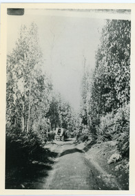
 Orbost & District Historical Society
black and white photograph, 1939
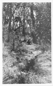
Buldah School was No. 4555. Mrs L. Petterson made application for a school at Buldah during 1936. It was opened on 8th of August 1937 by Herbert H. Eynstone acting as Head Teacher. He held this position for only about two weeks. The school closed during 1941. The Petterson brothers were early settlers in Cann River - late 19th century. This is a pictorial record of a school route in the first half of the 20th century. The Buldah School no longer exists.A black / white photograph of a bush track in a forest. There is water running across the track.on back - Don. by Mrs D. Petterson, only track to Buldah School in winter 1939...."buldah-east-gippsland -
 Kew Historical Society Inc
Photograph - Construction of the electric tram line in Riversdale Road, Camberwell, E.J. Dower, 1916
One of a series of photographs, taken by Edgar James Dower in the second decade of the twentieth century. Born and raised in Olinda, his family later moved to Surrey Hills. He worked as an adult as a clerk in the city office of the Metropolitan Gas Company, and in his role as a 'collector', he was able to photograph scenes including the construction of tramlines and associated buildings in Kew, Hawthorn, Camberwell and Surrey Hills. Later he established a real estate agency with his brother - the E.J. Dower Real Estate Agency, Dandenong Office.The image is an historically significant record of the development of transport infrastructure which was used to connect Victorians in the first two decades of the twentieth century. This development resulted from increases in population and the consequent extension of Melbourne's suburbs. The photographs, both individually and collectively, richly detail the labour of workers and the tools and machinery used to create and extend Melbourne's tram network in the years preceding and during World War 1.Digital copy of an original oval mounted photograph depicting preparation for laying the tracks for the new electric tramline in Riversdale Road, Camberwell. Annotated verso: "Riversdale Road / Preparing for electric tram line / Taken from near corner of Coolangatta Road"theme --- travelling by tram, theme -- connecting victorians by transport and communications, riversdale road -- camberwell, trams -- camberwell -
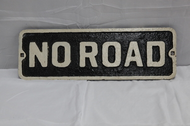 Puffing Billy Railway
No Road - End of platform sign
Historic - Railway - No Road Plate Sign Historic - Railway - No Road Plate Sign No Road Plate Sign Long rectangular plate that has been painted black and white with the words "no road" written across it. made of cast metal"No Road"puffing billy, sign, plate, no road sign -
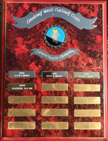 Geelong Cycling Club
Shield, 1996
This shield has an important place in the history of men in track cycling in the Geelong region at that time.Indicates the importance of men's track cycling competitions at this period.A mahogany coloured rectangular wooden shield with brass plated plaques containing inscriptions of winners of the senior men's track aggregate during the years 1996-2008. There is an emblem of a cyclist and two banners at the top centre of the shield. "Geelong West Cycling Club/Senior Track Championship/1996/Scott Moro/1997/Scott Moro/1998/Scott Moro/1999/Darren Allan"geelong west cycling club; senior track championship; scott moro;darren allan; -
 Melbourne Tram Museum
Slide - Set of 2, Keith Kings, 23/03/1968 12:00:00 AM
35mm Kodak white cardboard colour slide by Keith Kings of 23/3/68 and 6/4/68. .1 - Glenferrie Road Kooyong track renewal showing the first section of completed track. Shows two road crossovers. .2 - ditto, showing one end of the new crossover with temporary track on the right. See Keith's slide notes.Keith Kings stamp and number "20-19" and "20-32", with details of exposure. 23/3/68 and 6/4/68. .1 - "New concrete trackwork in Glenferrie Rd north from Kooyong railway Xing ready to be brought into use. Temporary track still in use at right" .2 - "New design for xover in Glenferrie Rd, near cnr Gardiner Rd Kooyong, Removable sections form the road surface and facilitate maintenance and renewal."trams, tramways, glenferrie road, trackwork, temporary track, kooyong -
 Glen Eira Historical Society
Photograph - Blencairn
... Corner Hawthorn and Glen Eira Roads, Caulfield, Victoria ...Four items about this mansion: 1/A black and white copy of a photograph (140mm x 110mm) of a Caulfield property with 2 adults and 4 young people positioned across the garden 2/Photocopied pages (2) out of the article '100 Years of Local Government - Early Caulfield' contained in 'Caulfield Centenary 1857-1957' by Mrs A. P. Bell showing the same photograph above as 'Slaney's Home, Hawthorn Road, Cnr Glen Eira Road'. Refer file 1441C for orignial copy of this booklet. 3/A one page typed document of the Caulfield Historical Society that identifies the property in the photograph as a Caulfield home and requests help in further identifying the property. The document contains handwritten notes concerning the property’s identification as 'Slaney's Home' and 'Blencairn'. 4/Additional research notes of cataloguer Lee Johns, taken 12/08/2011, concerning the identification and occupation of the house shown in the photograph and sourced from the book 'Caulfield’s Heritage' Volume 1 1989.blencairn, slaney’s home, hart thomas, centenaries, mansions, hawthorn road, slaney family, blencairn, caulfield, bell a. p. mrs, solomon geulah dr, glen eira road -
 Kew Historical Society Inc
Photograph - Electric tram line construction in Cotham Road, Kew, E.J. Dower, 1913
One of a series of photographs, taken by Edgar James Dower in the second decade of the twentieth century. Born and raised in Olinda, his family later moved to Surrey Hills. He worked as an adult as a clerk in the city office of the Metropolitan Gas Company, and in his role as a 'collector', he was able to photograph scenes including the construction of tramlines and associated buildings in Kew, Hawthorn, Camberwell and Surrey Hills. Later he established a real estate agency with his brother - the E.J. Dower Real Estate Agency, Dandenong Office.The image is an historically significant record of the development of transport infrastructure which was used to connect Victorians in the first two decades of the twentieth century. This development resulted from increases in population and the consequent extension of Melbourne's suburbs. The photographs, both individually and collectively, richly detail the labour of workers and the tools and machinery used to create and extend Melbourne's tram network in the years preceding and during World War 1.Digital copy of an original mounted photograph depicting construction of a new electric tramline in Cotham Road, Kew. The photo shows both a horse drawn and steam roller. A works supervisor and two men on bikes stand on the road to the left of the horse drawn roller. Annotated recto: "Preparing electric tram track / Cotham Road Kew / Near Normanby Road x. Annotated verso: "Preparing for electric tram / Cotham Road Kew / Taken near Normanby Road.theme --- travelling by tram, theme -- connecting victorians by transport and communications, cotham road -- kew (vic.), trams -- kew (vic.) -
 Mt Dandenong & District Historical Society Inc.
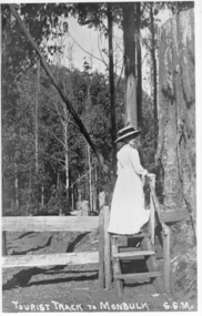
Photograph, Tourist Track To Monbulk, c1917
Miss Gwen Roberts, daughter of John and Roberta Roberts of Sunnyside, South Sassafras (now Kallista), climbing a style on the Monbulk Track.Tourist Track To Monbulk G.G.M.gwen roberts, monbulk track -
 Whitehorse Historical Society Inc.
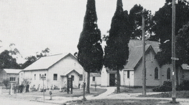
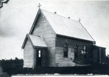
Photograph, St. Lukes Church, C.1950's
... Vermont, Mitcham & Canterbury Roads. ...Part of The Shambrook Collection for 'This is Vermont'. Not used.Black and white photo of St. Lukes Church, Corner of Mitcham and Canterbury Roads, Vermont in 1950's.st. lukes anglican church, vermont, shambrook, tim -
 Melbourne Tram Museum
Slide, Keith Kings, 10/08/1968 12:00:00 AM
35mm Kodak white cardboard colour slide by Keith Kings of 10/8/1968 Queensway, St Kilda Junction road works, track tamping using a VR hired tamper. Note the cloth wrapped up caps on two of the workers - Italian immigrants most likely. See Keith's slide notes.Keith Kings stamp and number "32-27", with details of exposure. "VR tampers on hire in Freeway section of new track near Punt Road 10/8/68".trams, tramways, st kilda junction, trackwork, road works, queensway, ballast -
 Whitehorse Historical Society Inc.
Photograph, St. Lukes Church, Vermont, 1910, C.1910
... Vermont, Canterbury & Mitcham Roads. ...Part of Tim Shambrook's Collection for 'This is Vermont', P. 21.Black and white photo of original wooden St. Lukes Church, 1910, corner of Mitcham and Canterbury Roads, Vermont.shambrook, tim -
 Kew Historical Society Inc
Photograph - Removal of the horse tram line in Riversdale Road, Hawthorn, E.J. Dower, c.1916
One of a series of photographs, taken by Edgar James Dower in the second decade of the twentieth century. Born and raised in Olinda, his family later moved to Surrey Hills. He worked as an adult as a clerk in the city office of the Metropolitan Gas Company, and in his role as a 'collector', he was able to photograph scenes including the construction of tramlines and associated buildings in Kew, Hawthorn, Camberwell and Surrey Hills. Later he established a real estate agency with his brother - the E.J. Dower Real Estate Agency, Dandenong Office.The image is an historically significant record of the development of transport infrastructure which was used to connect Victorians in the first two decades of the twentieth century. This development resulted from increases in population and the consequent extension of Melbourne's suburbs. The photographs, both individually and collectively, richly detail the labour of workers and the tools and machinery used to create and extend Melbourne's tram network in the years preceding and during World War 1.Digital copy of an original mounted photograph of the removal of the horse tram tracks in Riversdale Road, Hawthorn, in preparation for laying the new electric tramline.Annotated verso: "Pulling up Hawthorn horse tram line in Riversdale Road, which ran from Hawthorn Bridge to Auburn Road"theme --- travelling by tram, theme -- connecting victorians by transport and communications, trams -- boroondara (vic.), horse tram -- hawthorn (vic.), riversdale road -
 Kew Historical Society Inc
Photograph - Construction of the electric tram line in Riversdale Road, Surrey Hills, E.J. Dower, 1916
Contextual or historic information One of a series of photographs, taken by Edgar James Dower in the second decade of the twentieth century. Born and raised in Olinda, his family later moved to Surrey Hills. He worked as an adult as a clerk in the city office of the Metropolitan Gas Company, and in his role as a 'collector', he was able to photograph scenes including the construction of tramlines and associated buildings in Kew, Hawthorn, Camberwell and Surrey Hills. Later he established a real estate agency with his brother - the E.J. Dower Real Estate Agency, Dandenong Office.The image is an historically significant record of the development of transport infrastructure which was used to connect Victorians in the first two decades of the twentieth century. This development resulted from increases in population and the consequent extension of Melbourne's suburbs. The photographs, both individually and collectively, richly detail the labour of workers and the tools and machinery used to create and extend Melbourne's tram network in the years preceding and during World War 1.Digital copy of an original oval mounted photograph depicting preparation for laying the tracks for the new electric tramline in Riversdale Road, Surrey Hills. Annotated verso: "Riversdale Road Surry Hills / preparing for electric tram line / Taken just west of Middlesex Road, looking west"theme --- travelling by tram, theme -- connecting victorians by transport and communications, trams -- boroondara (vic.), riversdale road -- surrey hills -
 Halls Gap & Grampians Historical Society
Photograph - B/W
Photo shows a sheep on Zumstein's/MacKenzie Falls track 1925Sheep on Zumstein McKenzie Falls walking track / Stan Parfettaccess routes, walking track -
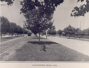 St Kilda Historical Society
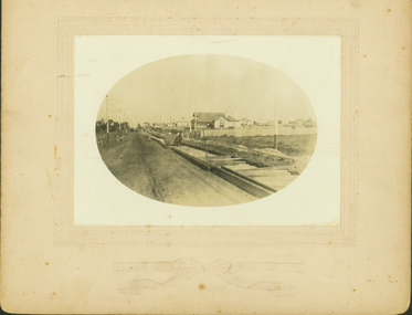
Photograph - Photograph of Dandenong Rd, Dandenong Road 1931, 1931
A black and white photograph of an earlier print, showing the central park in the middle of Dandenong Road, including trees and the tram tracks along with a tram several cars and some pedestrians walking by.Dandenong Road, 1931 -
 Kew Historical Society Inc
Photograph - Electric tram line construction in Cotham Road, Kew, E.J. Dower, 1913
One of a series of photographs, taken by Edgar James Dower in the second decade of the twentieth century. Born and raised in Olinda, his family later moved to Surrey Hills. He worked as an adult as a clerk in the city office of the Metropolitan Gas Company, and in his role as a 'collector', he was able to photograph scenes including the construction of tramlines and associated buildings in Kew, Hawthorn, Camberwell and Surrey Hills. Later he established a real estate agency with his brother - the E.J. Dower Real Estate Agency, Dandenong Office.The image is an historically significant record of the development of transport infrastructure which was used to connect Victorians in the first two decades of the twentieth century. This development resulted from increases in population and the consequent extension of Melbourne's suburbs. The photographs, both individually and collectively, richly detail the labour of workers and the tools and machinery used to create and extend Melbourne's tram network in the years preceding and during World War 1.Digital copy of an original mounted photograph depicting construction of a new electric tramline in Cotham Road, Kew. The photo shows a worker standing on the tracks at the then terminus.Annotated verso: "Preparing for electric trams / Cotham Road Kew / Taken from corner of Burke Road / 1913"theme --- travelling by tram, theme -- connecting victorians by transport and communications, cotham road -- kew (vic.), trams -- kew (vic.) -
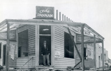 Whitehorse Historical Society Inc.
Photograph, Chas. Pannam's General Store
... Vermont, Canterbury & Boronia Roads. ...Part of Tim Shambrook's Collection for 'This is Vermont', but not used.Black and white photo of Chas. Pannam standing in doorway of his General Strore which stood on corner of Boronia and Canterbury Roads, Vermont.pannam's store, pannam, charles., shambrook, tim -
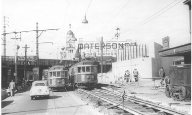 Melbourne Tram Museum
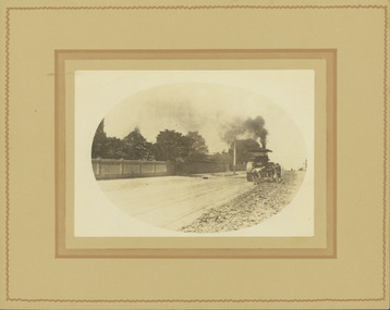
Photograph - Black and White - Swan Street track lowering, John Alfred, 1957
Photo shows - works in Swan Street Richmond to lower the tram tracks under the Railway bridge which were later replaced by an open web girder truss bridge. The track on the left has been completed while on the right, the original road surface can be seen as well as the temporary track. Shows the abutment for a new railway bridge on the right, for the six tracks to South Yarra. Tram W2 330 (left, Camberwell Depot, route 76) and 339 (City, route 77) are passing each other. In the background is a large advertisement for Pattersons home furnishings. Photo dated 1957.Yields information about alterations to tram services during road reconstruction project.Photograph - Black and White - Swan Street track lowering Has details handwritten on rear, date stamp and John Alfred Stamp. tramways, tramcars, swan street, richmond, route 77, railways, bridges, tram 330, tram 339 -
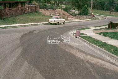
 Eltham District Historical Society Inc
Slide - Photograph, Eltham Shire Council, Unidentified road; Infrastructure works, roads, footpaths and drainage, Shire of Eltham, c.1972
... Unidentified road; Infrastructure works, roads, footpaths ...35mm colour positive transparency blue Agfacolour Service plastic mount1972, footpaths and gutters, infrastructure, road construction, road drainage, roadworks, shire of eltham, unidentified -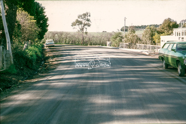
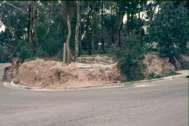
 Eltham District Historical Society Inc
Slide - Photograph, Eltham Shire Council, Unidentified road, possibly Kangaroo Ground; Infrastructure works, roads, footpaths and drainage, Shire of Eltham, c.1972
... works, roads, footpaths and drainage, Shire of Eltham ...35mm colour positive transparency blue Agfacolour Service plastic mount1972, footpaths and gutters, infrastructure, road construction, road drainage, roadworks, shire of eltham, unidentified, kangaroo ground -
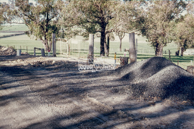 Eltham District Historical Society Inc
Slide - Photograph, Eltham Shire Council, Unidentified road, possibly Kangaroo Ground; Infrastructure works, roads, footpaths and drainage, Shire of Eltham, c.1972
... works, roads, footpaths and drainage, Shire of Eltham ...35mm colour positive transparency blue Agfacolour Service plastic mount1972, footpaths and gutters, infrastructure, road construction, road drainage, roadworks, shire of eltham, unidentified, kangaroo ground