Showing 10893 items
matching village
-
 Canterbury History Group
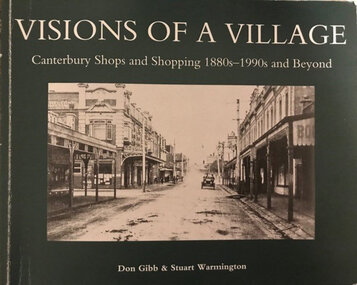
Book, Don Gibb et al, Visions of a Village : Canterbury shops and shopping 1880s-1990s, 2007
Focussing on the growth and activities that took place in the shopping and service centre of Canterbury and Maling Roads in Canterbury from the 1880s to the present, it is partly a guide book to the present buildings of the centre through the streetscapes and brief lives of each of the premises.74 pages; black and white illustrations and photographs, including sketches of streetscapes. Includes bibliographical references and indexnon-fictionFocussing on the growth and activities that took place in the shopping and service centre of Canterbury and Maling Roads in Canterbury from the 1880s to the present, it is partly a guide book to the present buildings of the centre through the streetscapes and brief lives of each of the premises.canterbury road shopping centre, maling road, maling road> shops, shops, retail trade, commercial establishments, streetscapes, gibb> don, warmington> stuart -
 Canterbury History Group
Book, Don Gibb et al, Visions of a Village : Canterbury shops and shopping 1880s-1990s and Beyond, 2016
Focussing on the growth and activities that took place in the shopping and service centre of Canterbury and Maling Roads in Canterbury from the 1880s to the present, it is partly a guide book to the present buildings of the centre through the streetscapes and brief lives of each of the premises.74 pages; black and white illustrations and photographs, including sketches of streetscapes. Includes bibliographical references and indexnon-fictionFocussing on the growth and activities that took place in the shopping and service centre of Canterbury and Maling Roads in Canterbury from the 1880s to the present, it is partly a guide book to the present buildings of the centre through the streetscapes and brief lives of each of the premises.canterbury road shopping centre, maling road, maling road> shops, shops, retail trade, commercial establishments, streetscapes, gibb> don, warmington> stuart -
 National Vietnam Veterans Museum (NVVM)
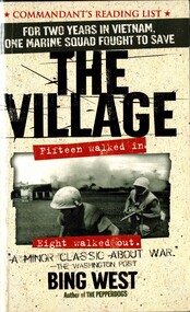
Book, West, Bing, The Village: Fifteen Walked In, Eight Walked Out
For two years in Vietnam,one marine squad fought to save the village.For two years in Vietnam,one marine squad fought to save the village.vietnam war, 1961-1975 - personal narratives, american, combined action platoons (caps), viet cong, united states. marine corps - biography -
 Eltham District Historical Society Inc
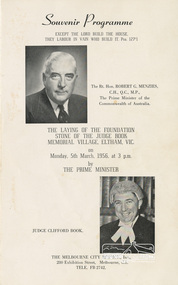
Souvenir Program, J.S., McClelland Pty Ltd, Souvenir Programme: The Laying of the Foundation Stone of the Judge Book Village, Eltham, Vic. on Monday, 5th March, 1956, at 3 p.m. by The Prime Minister, 1956
Melbourne City Mission celebrated the laying of the Foundation stone by the Prime Minister Robert Menzies for their aged care residences. The program includes images and program for the event incuding national anthem, Welcome by the Shire Presidnet T. E. Shepherd, a scripture and prayer, a welcome to the PM, the laying of the stone, a musical item by Ella Johnson, an address by Rev. J. Arthur Lewis, annoucements, afternoon tea and a list of costs associated with the venture.Bi-fold (4 pages) printed both sides 23.7 x 14.7 cmjudge book village, plaisted & warner architects, prime minister, robert menzies, judge clifford book, foundation, melbourne city mission -
 Whitehorse Historical Society Inc.
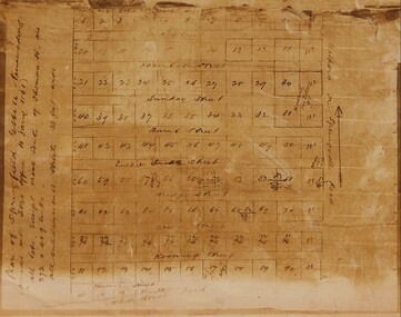
Map - Civic Map, Subdivision of Village of Springfield, 1861
Map of the subdivision of the Springfield Estate, Nunawading, 1861. The Springfield Estate was located in the Northwest corner of Whitehorse Road and Springvale Road.Map of the subdivision of the Springfield Estate, Nunawading, 1861. Springfield Estate was located in the Northwest corner of Whitehorse Road and Springvale Road.non-fictionMap of the subdivision of the Springfield Estate, Nunawading, 1861. The Springfield Estate was located in the Northwest corner of Whitehorse Road and Springvale Road.springfield estate, whitehorse road nunawading, springvale road nunawading -
 Greensborough Historical Society
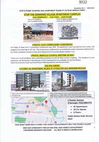
Document - Planning Document, Diamond Village Apartment Complex, 2019
A collection of documents discussing opposition to the Diamond Valley Apartment Complex, a high-rise apartment development planned for Nepean Street Greensborough.13 pages of Text with coloured photographs and mapdiamond village apartment complex, building permits, nepean street greensborough -
 Marriner Group Theatres Archive
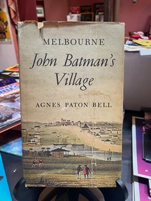
Book, Melbourne John Batman's Village
-
 Darebin Art Collection
Painting, Sharon West, No Place for a Village, 2006
painting -
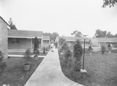
 Ringwood and District Historical Society
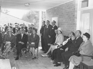
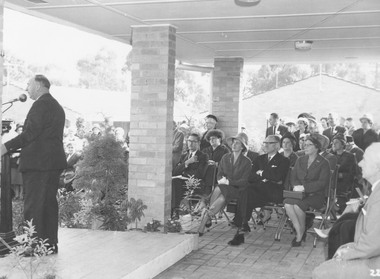
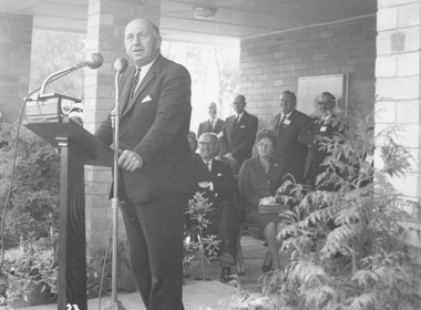
Photograph, Opening of Lionswood Retirement Village, Kirk Street, Ringwood - May, 1963
Black and white photograph showing a group of personalities seated and standing during opening ceremony.Written on back of photograph: "Lionswood opening, May 1963." Attendees include Sir Henry Bolte second (from) RHS. Mayor of Ringwood Max Deuter and Mrs Deuter. -
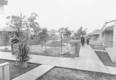
 Ringwood and District Historical Society
Photograph, Opening day of Lionswood Retirement Village, Kirk Street, Ringwood - May, 1963
Black and white photograph showing exterior view of units, with garden areas under construction.Written on back of photograph: "Lionswood Opening, May 1963." -
 Ringwood and District Historical Society
Photograph, Opening day of Lionswood Retirement Village, Kirk Street, Ringwood - May, 1963
Black and white photograph showing exterior view of units, with garden areas under costruction.Written on back of photograph: "Lionswood Opening, May 1963." -
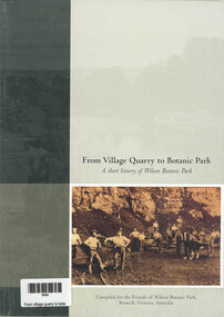 Narre Warren and District Family History Group
Book, Friends of Wilson Botanic Park, From Village Quarry to Botanic Park - A short History of Wilson Botanic Park, 2004
A history of Wilson Botanic Park, including its geological history and palaeobotany, and chapters on pre-European history and Aboriginal settlement, European settlement, the growth of the township of Berwick, the Wilson Quarry, the gift of the site to the people of Berwick, and the growth of the park since its opening in 1992.40 p.; 24 cmnon-fictionA history of Wilson Botanic Park, including its geological history and palaeobotany, and chapters on pre-European history and Aboriginal settlement, European settlement, the growth of the township of Berwick, the Wilson Quarry, the gift of the site to the people of Berwick, and the growth of the park since its opening in 1992.berwick (vic.), wilson botanic park, george lindsay wilson, fay wilson (nee duff), george pritchard harvey wilson, james wilson -
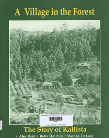 Narre Warren and District Family History Group
Book, Alec Reid et al, A village in the forest : the story of Kallista, 1993
A history of the Kallista district, divided into chronological sections. Includes illustrations and index.164 p.; 27 cmnon-fictionA history of the Kallista district, divided into chronological sections. Includes illustrations and index. kallista (vic.), sassafras (vic.) -
 Ringwood and District Historical Society
Photograph, Opening of Lionswood Retirement Village, Kirk Street, Ringwood - May, 1963
Black and white photographWritten on rear of backing sheet: "Lionswood opening 1963. Sir Henry Bolte (speaking)." -
 Ringwood and District Historical Society
Photograph, Opening of Lionswood Retirement Village, Kirk Street, Ringwood - May, 1963
Black and white photographWritten on back of photograph: "Lionswood opening, May 1963." -
 Ringwood and District Historical Society
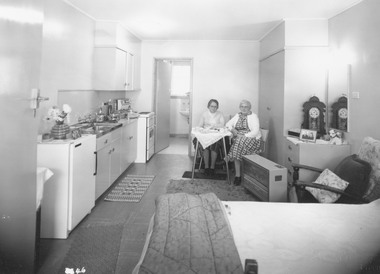
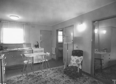
Photograph, Opening day of Lionswood Retirement Village, Kirk Street, Ringwood - May, 1963
Black and white photograph showing two ladies sitting inside unit.Written on back of photograph: "Lionswood opening. Interior of a flat." -
 Ringwood and District Historical Society
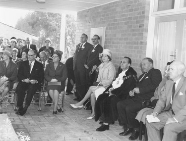
Photograph, Opening of Lionswood Retirement Village, Kirk Street, Ringwood - May, 1963
Black and white photograph showing a group of personalities seated and standing during opening ceremony.Written on back of photograph: "Lionswood opening, May 1963." Attendees include Sir Henry Bolte, Mayor of Ringwood Cr Max Deuter and Mrs Deuter. -
 Ringwood and District Historical Society
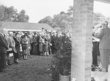
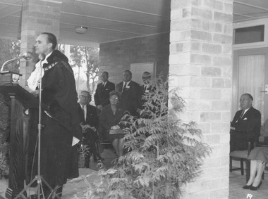
Photograph, Opening of Lionswood Retirement Village, Kirk Street, Ringwood - May, 1963
Black and white photograph showing Premier of Victoria Mr.H.E. Bolte speaking at opening ceremony.Written on rear of backing sheet: "Opening Lionswood, May 1963." -
 Ringwood and District Historical Society
Photograph, Opening of Lionswood Retirement Village, Kirk Street, Ringwood - May, 1963
Black and white photograph showing Ringwood Mayor, Cr Max Deuter speaking at opening ceremony.Written on back of photograph: "Lionswood opening, May 1963." -
 Ringwood and District Historical Society
Photograph, Opening day of Lionswood Retirement Village, Kirk Street, Ringwood - May, 1963
Black and white photograph showing interior of unit.Written on rear of backing sheet: "Lionswood opening, May 1963. Interior of a flat." -
Buninyong & District Historical Society
Photograph - B/W photograph, Buninyong Town Choir, winners of Provincial Choral Contest, South Street Competition, 1908, (photo) 1908
Buninyong Town Choir (aka "Ye Ancient Village Choir) winner at South Street Competitions 1908Historical record, ephemeraSmall group of documents relating to Buninyong Town Choir, copy of photograph and original (on Songbook) songbook(On songbook) stamp "YE ANCIENT VILLAGE CHOIRbuninyong, choir, south street competiton -
 Marysville & District Historical Society
Photograph (Item) - Colour photograph, 1998
A colour photograph that shows the entrance to The Village in Marysville in Victoria.A colour photograph that shows the entrance to The Village in Marysville in Victoria. This residential village was destroyed in the 2009 Black Saturday bushfires.the village, marysville, victoria, 2009 black saturday bushfires, photograph -
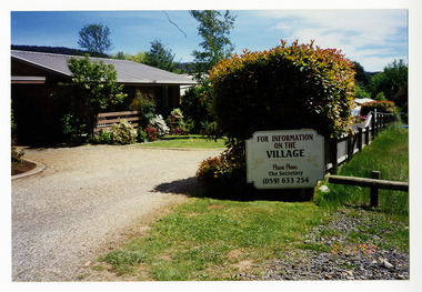
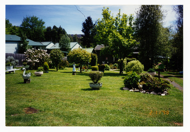 Marysville & District Historical Society
Photograph (Item) - Colour photograph, 1998
A colour photograph that shows the gardens at The Village in Marysville in Victoria.A colour photograph that shows the gardens at The Village in Marysville in Victoria. This residential village was destroyed in the 2009 Black Saturday bushfires.the village, marysville, victoria, 2009 black saturday bushfires, photograph -
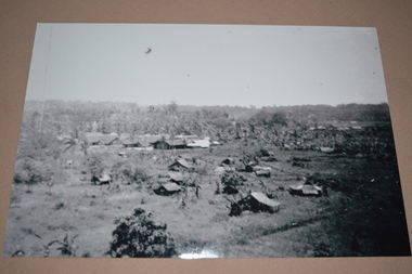 Wangaratta RSL Sub Branch
Photograph
Image appears to be of rural village and outlying buildings on Tarakan Island The 2/24th Battalion was an infantry battalion of the Australian Army, which served during World War II .A unit of all-volunteers, it was formed in July 1940 from primarily Victorian volunteers and was known as "Wangaratta's Own" because of the time the battalion spent in the town during its formative period prior to deployment overseas. It served in North Africa in 1941–1942 as part of the 26th Brigade, which was assigned to the 7th Division, before being reassigned to the 9th Division. In early 1943, the battalion returned to Australia and later took part in campaigns against the Japanese in New Guinea in 1943–1944 and Borneo in 1945, before being disbanded in 1946. The 2/24th suffered the highest number of casualties of any 2nd AIF infantry battalion. The Unit was granted the Freedom of the City by the Rural City of Wangaratta in 1996 and one of the first, if not the first, to receive this type of honour. Reproduced black and white photograph of distant village in countrysideOn rear - Tarakan2/24th battalion, tarakan, ww2 -
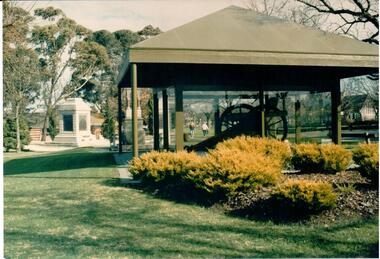 Hume City Civic Collection
Photograph, 1980s
The Sunbury Gun was placed in this airconditioned room in the Village Green after it was restored. A coloured photograph of the Sunbury Gun in the Village Green precinct.gun, sunbury, village green, starkie fountain, fountains, clarke, william (sir), russell, janet (lady), starkie, joseph, war memorials, monuments and statues, church of england, churches, george evans collection -
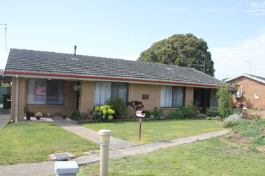 Old Colonists' Association of Ballarat Inc.
Photograph - Photograph - Colour, Clare Gervasoni, Titheridge Cottage, Charles Anderson Grove, Ballarat, 2017, 14/06/2017
The Old Colonists' Association Retirement Village is located at Charles Anderson Grove. The Titheridge home in the Ballarat Old Colonists' Association Retirement Village.charles anderson grove, ballarat, ballarat old colonists' club, old colonists' association, ballarat, titheridge cottage -
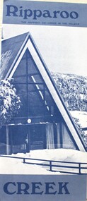 Falls Creek Historical Society
Booklet - Ripparoo Lodge, 1973
Ripparoo Lodge was one of the earliest Lodges established in the Falls Creek Village. In the 1960s, Bob and Noelene Lee moved to Falls Creek to run Ripparoo Lodge. They later built Attunga Ski Lodge. Both of these lodges still operate successfully in the 2020s.This brochure is significant because it represents one of the early lodges at Falls Creek. A fold out brochure printed in blue and white, it include some images and cartoons of people enjoying hospitality at Ripparoo. Information on tariffs and services is included.Title - Ripparoo The happiest ski lodge in the village.falls creek accommodation, ripparoo, falls creek lodges -
 Kew Historical Society Inc
Photograph - K Class 217 (Birney Safety Car) in Doncaster & North Balwyn Village, 1990
This colour photograph, with 15 others are enlargements gifted to the Society by Mel Lawrence in 2016. They were taken at a commemorative event from the Kew Tram Depot. Laminated colour enlargement of a K Class 217 (Birney Car) in Doncaster & North Balwyn Village taken at a re-enactment from the Kew Depot in 1990.Annotation reverse: "Kew Depot 1990. K Class 217 (Birney Car) in Doncaster & North Balwyn village. Original location of East Kew Depot"kew tram depot, k class trams, birney safety car -
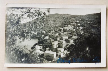 Ithacan Historical Society
Photograph, Kioni, Ithaca, 1920s
View across the picturesque Ithacan village of Kioni taken by Thalia Paizis (Papadopoulos) when she returned to Greece in 1921. Thalia later returned to Australia where she married Anastasios Papadopoulos.Many Ithacans from the village of Kioni migrated to Australia and settled in Melbourne. These days Kioni is one of the most popular destinations for visitors to Ithaca and for yachts cruising the Ionian islands in the some months.A black and white photograph of a view of a village on a hillside by the sea. -
 Kiewa Valley Historical Society
Photo - Bogong Township, March 1944
In 1940 Field Headquarters for the Kiewa Scheme were established at Bogong with office, workshop facilities and accommodation for workmen, staff and some families constructed. (There had been a 'tent camp' on this site in 1939 but was destroyed by bushfires) Construction of accommodation continued until 1947. A total of 40 houses plus a hostel for single staff, post office, police station, medical centre and primary school all with water and sewerage and electricity supply. The staff hostel was known as Kiewa House and is now occupied by the Education Department. Lake Guy was named after Mr. L.T. Guy who was the Resident Engineer in charge of construction work and associated activities on the Kiewa area. He held this position from 1939 to November 1946 when he was transferred to Head Office. The Bogong Township was developed firstly as an accommodation centre (base camp) for construction workers employed under the Kiewa Hydroelectric Scheme. Due to the influx of European workers into the Township the beautification of the immediate surrounds (gardens etc.) had a distinct European flavour. This environment has been very beneficial for tourism in later years. At the completion of the scheme, in the 1960's, the village was opened to public/tourism use. Strict environmental control has not allowed for any extensive redevelopment in tourist accommodation and basically restricted it to the accommodation initially built for the construction workers. Activities such a bike riding, snow skiing, restricted horse riding and bush walking on the Alpine plains and mountains are now a viable part of the Kiewa Valley Tourist Industry. The lake is one of the many water storage reservoirs used to supply the power stations their main power to run the huge turbines generating the final product, electricityBlack and white photograph of Bogong Township taken March 1944Handwritten on the back of photo - Township March '44bogong village, secv