Showing 389 items
matching water reserve
-
 Ballarat Tramway Museum
Pamphlet, State Electricity Commission of Victoria (SECV), advertising free briquettes to SEC employees, late 1960's
Yields information about the method of promotion of the sales of briquettes amongst SEC employees and the sale of gas heaters.Printed - two colours - pamphlet, with black border top and bottom of the sheets, advertising free briquettes to SEC employees and relatives on the installation of a hot water heater or space heater. Late 1960's - has a 7 digit telephone contact number. In top left hand corner has the name "Everett" On rear has various calculations in pencil. Was loose with the group of track diaries - eg around Reg Item 3703.trams, tramways, sec, briquettes, personnel -
 Ballarat Tramway Museum
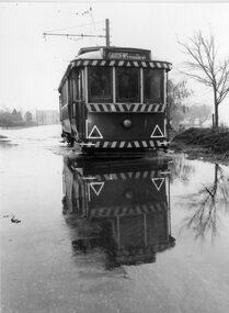
Photograph - Black & White Photograph/s, The Courier Ballarat, 27/05/1963 12:00:00 AM
Yields information about the occasional weather conditions that a tramway operation around Lake Wendouree could encounter - flooding.Black and White copy photograph of a newspaper photograph taken by The Courier - 27/5/1963, published 28/5/1963 of No. 14 in water (blocked drain), Wendouree Parade & St Aidans Dve - wading through the floods. Collected by Alan Bradley from the Ballarat Courier early 1980's. See Excel file "Record of Ballarat Courier Photos SEC era" (Archive Documents) for source of details. See Reg Item 5604 for original of newspaper cutting.On rear stamped "Copyright, The Ballarat Courier Proprietary Limited." and in pencil "B.C. Battern".tramways, trams, wendouree parade, flooding, st aidans drive, tram 14 -
 Ballarat Tramway Museum
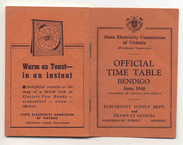
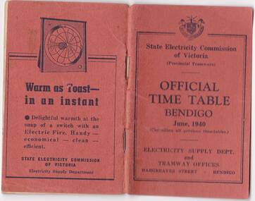
Ephemera - Timetable/s, State Electricity Commission of Victoria (SECV), "Official Time Table Bendigo June 1940", Jun. 1940
Centre pages show a map of the system and the sections. The extension to North Bendigo is yet to be constructed. Gives times for trams leaving the city or the terminals for the routes and for the Eaglehawk route, leaving Long Gully Bridge. Has four SECV Advertisements within the book for hot water, ovens - cookers, toasters and electric fan heaters. Three copies held. See item 5356 for a digital image of the same document with a photograph of Len Smith of Geelong loading a pram into a Birney tram.Provides details of 1940 tram services in Bendigo.Forty-page booklet, with orange lightweight covers, saddle-stapled, SECV Provincial Tramways with the title "Official Time Table Bendigo June 1940". Has address if Hargreaves St Bendigo on bottom of the cover. Two copies held.bendigo, timetables, secv -
 Ballarat Tramway Museum
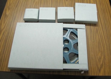
Film - Movie Film & Box, 1970s
Movie Film - 16mm on a black metal reel, 91mm dia. Title: Train Carriages Interior Shots – Length 1:20 mins, colour, 16mm Colour with sound. (Reg Item 4110 - source not known at this time.) Time Sequence Description 0:00 Starts with a training running past, view of wooden carriages, C van and then interior shots of train, toilets, washbasin, electrical equipment, water dispenser, signs, seats, walk ways between carriages and light fittings. 1:20 End Placed in a blue cardboard box specially made for the item 30/08/2010. trams, tramways, victorian railways -
 Ballarat Tramway Museum
Photograph - Black & White Photograph/s - set of 2, John Phillips, late 1960's
Black and White photograph of No. 41 and 21 at the Sebastopol terminus. No. 41 has the destination of "Bell St" (shown for the photographer?) and two Johnnie Walker roof advertisements. Photo taken late 1960's. Believed that the print and photo by John Phillips. .1 - Display copy mounted on heavy cardboard, with remnants of Velcro strips on the back, minor water damage, sticky tape from use. tramways, trams, sebastopol, tram 41, tram 21 -
 Ballarat Tramway Museum
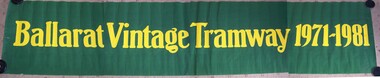
Poster, Ballarat Tramway Preservation Society (BTPS), "Ballarat Vintage Tramway 1971 - 1981", Sep. 1981
Poster of banner, "Ballarat Vintage Tramway 1971 - 1981" used in the opening of the new or depot extension 14/6/2001 at the depot at the opening on 19/9/1981. Painted using water based poster paint, onto a roll of white paper, with a green background, the words have been pained in yellow blue. Has been torn or broken centrally at the time of the launch. Has been stored rolled - partially oval. btm1777i1 - shows banner - photographed in four stages and then joined using photoshop. btm1777i2 - shows banner - in use at the depot on 19/9/1981 - See 1981- 1982 BTPS Annual Report for further details. See Annual Report 1981 - 1982trams, tramways, depot extensions, btps, launch, banner -
 Ballarat Tramway Museum
document - Correspondence, State Electricity Commission of Victoria (SECV), "Opening up of tram tracks by Plumber etc", Mar. 1937
Yields information about the correspondence between the SEC staff about the opening of tram tracks for underground services.Original of a report, handwritten in pencil from a copy book (pages 26 and 27), dated 23/3/1937, addressed to the Manager, from Mr. Mawby titled "Opening up of tram tracks by Plumber etc" reporting on a Mr. McLean excavating under track in Drummond St on 23/3 for a Ballarat Water Board pipe and the issues that arose. No notification to the SEC, underground services, and the absence of advice from traffic crews. Gas company also mentioned in the letter.Various initials and notes in red pencil or ink.tram, trams, letters, sec, tram track -
 Ballarat Tramway Museum
Photograph - Digital image, 1/08/2009 12:00:00 AM
Yields information about the condition of Lake Wendouree following a prolonged drought, photographed with some water in it during the winter of 2009.Digital Image of BTM Tram No. 14 at the St Aidans Drive terminus, 1/8/2009 with an almost dry Lake Wendouree in the background and green grass on the lake bed. There is some water in the lake after a long drought..trams, tramways, lake wendouree, drought, st aidans drive, tram 14 -
 Ballarat Tramway Museum
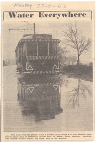
Newspaper, The Courier Ballarat, "Water Everywhere", 28/05/1963 12:00:00 AM
Yields information about the occasional weather conditions that a tramway operation around Lake Wendouree could encounter - flooding.Newspaper clipping from The Courier, 28/5/1963, titled "Water Everywhere", of No. 14 in water (blocked drain), Wendouree Parade & St Aidans Dve - wading through the floods. See Reg Item 3735 for a print of the photograph. Contained originally within Reg Item 5507 at the back of the binder. For items see btm5507 loose items list.pdf "Monday 27-5-63", in ink.wendouree parade, flooding, st aidans drive -
 Ballarat Tramway Museum
Photograph - Digital image, State Electricity Commission of Victoria (SECV), "Official Timetable Bendigo June 1940"
Yields information about the Bendigo Tram services.Digital image or copy of the SEC "Official Timetable Bendigo June 1940", 22 image files - 44 pages, giving details of the fares, transfers, luggage or parcels, lost property, times of each tram on the Quarry Hill, Eaglehawk, Lake Weeroona and Golden Square for both directions and Monday to Thursday, Friday, Saturday and Sunday. Has a number of advertisements for SEC home equipment, cookers, toasters, refrigerator, electric radiators and hot water. In the middle page is a map of the Tramway Routes, which has been hand drawn to shown North Bendigo and the depot location. Inside the rear cover, on a sheet headed "Memorandum" is a photograph, taped in of a conductor loading a pram onto a Birney tram. Under the photograph is in ink "Len Smith (Geelong)" See item3127 for an original copy and pdf scan. trams, tramways, bendigo, timetables -
 Ballarat Tramway Museum
Photograph - Colour Photograph/s - set of 2, Stephen Butler, c9/1978
Yields information about the construction of the BTPS Depot extensions c Sept. 1978.Set of 2 colour prints of tram the depot extensions being constructed c September 1978. .1 - view from 2 /3 road points with a tram on the 3 road extension. .2 - photo of 4 road pit with water in it. See Annual Report and September 1978 Fares Please!trams, tramways, btps, depot extensions -
 Ballarat Tramway Museum
Negative - Copy, Ray Pearson
Set of 19 copy negatives, of black and white photographs of Geelong trams from Ray Pearson Collection, taken by Dave Macartney in 1975c. Original negative held in the negative file. Scanned at 2400 dpi and cropped as necessary. Images as shown replaced by scan from the original Ray Pearson Album provided by Mal Rowe, April 2020 or that there is a better image. .1 - sprinkler/water tram - see Reg Item 5894 for a better version of this photograph. .2 - No. 11 summer car, side on view - image replaced. .3 - Postcard, No. 14 summer car, Moorabool St Geelong, Real Photo 1535 - image replaced. .4 - Postcard, No. 27, Valentine Series No. 1468, Ryrie St - image replaced .5 - Postcard No. 23, Valentine 1434, Moorabool St - image replaced .6 - Postcard, Rose Series P75, Moorabool St - image replaced .7 - No. 8 - image replaced .8 - old tram after sale .9 - No. 29 Birney - See also Reg Item 5852 for a better version of this photograph .10 - No. 14 - East - see also Reg Item 5847 for a better version of this photograph. .11 - No. 25 - Belmont - see also Reg Item 5870 for a better version of this photograph. .12 - sprinkler/water tram - image replaced .13 - No. 303, in Adelaide - before becoming Geelong 27, has destination of Rosewater - image replaced .14 - 9, 20 and 22 at depot - image replaced .15 - No. 3 - see also Reg item 5826 for a better version of this photograph. .16 - No. 26 - see also Reg Item 5872 for a better version of this photograph. .17 - No. 27 0 see also Reg Item 5851 for a better version of this photograph. .18 - Floral Tram - 1938 - image replaced .19 - No. 28 at Station, Newtown - image replaced trams, tramways, geelong, floral tram, birney -
 Ballarat Tramway Museum
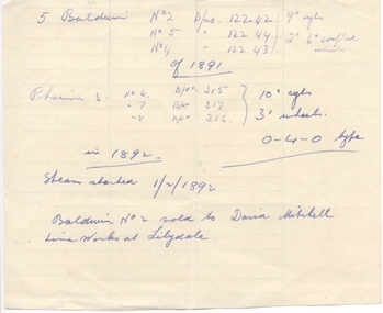
Document - Handwritten Notes, Wal Jack, Bendigo steam trams, 1940's
Hand made note regarding the Bendigo steam trams, their builders, builder numbers, sizes and dates. Notes one sold to the David Mitchell Lime Works at Lilydale. Contained within Reg Item 5485 - Service Exercise Book, black covers, with label, red binding titled "No. 2 - Ballarat Tramways & S.E.C. Systems". Item was located inside the front cover of this book - see list, The sheet of paper has the water mark - "GOVERNMENT SUPERFINE" with a crown over the top of words. trams, tramways, bendigo, steam trams -
 Ballarat Tramway Museum
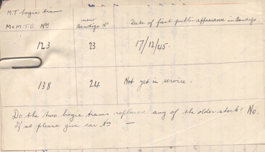
Document - Handwritten Notes, Wal Jack, Tram mileage notes, 1945
Hand made note regarding the Bendigo bogie tramcars No. 23 and 24, ex Melbourne numbers and date in service and whether they replaced any previous Bendigo tramcars - answer No. Contained within Reg Item 5485 - Service Exercise Book, black covers, with label, red binding titled "No. 2 - Ballarat Tramways & S.E.C. Systems". Item was located inside this book - see list - in the Bendigo tram list and held with a paper clip - remnant as marks remain. Scanned when held with the paper clip. The sheet of paper has the water mark - "'COLNE VALLEY PARCHMENT" trams, tramways, bendigo, bogie trams -
 Ballarat Tramway Museum
Photograph - Digital image, late to mid 1930's
Yields information about the appearance of one of Ballarat Scrubber tram soon after it was converted from a Ballarat Sebastopol car in Wendouree Parade.Digital image from the Wal Jack Ballarat Album of the Ballarat Scrubber, in Wendouree Parade mid to late 1930's. Could have been photographed after completion. Wal's album notes "Water & Scrubber car ex "Sebastopol Type No. 23 converted 1935". Has a broom inside the tram. Lake Wendouree in the background. See image i2 for rear of photograph. See image i3 for hi res scan of print. See image i4 for hi res scan of negativeon rear of photo in ink, "Ballarat Tramways water car"trams, tramways, scrubber tram, lake wendouree, scrubber -
 Ballarat Tramway Museum
Photograph - Digital image, March 1958
Yields information about the size of the water tank that was fitted to the ESCo built sprinkler tram for Ballarat.Digital image from the Wal Jack Ballarat Album of the storage tank from the old or original ESCo sprinkler car, noted in use on a local farm at Invermay. No details as to source of print, Wal's notes the date as March 1958. See image i2 for rear of photograph.On rear of photograph in ink "Ballarat Tramways, Storage tank from old Sprinkler car, now in use on local farm at Invermay"trams, tramways, sprinkler tram, scrubber tram, esco -
 Ballarat Tramway Museum
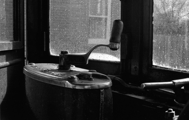
Photograph - Digital image, 1970s
Yields information about the driver's tram controller in a single trucker or four wheel tram.Digital image looking out of the cab from the drivers seat across a WH T1F controller with water on the windscreen. Photo taken by Peter Bruce 1970's and 1971, prior to the closure of the Ballarat tramway system. Peter's Title of image: "A thing of beauty"trams, tramways, ballarat, controllers, drivers -
 Ballarat Tramway Museum
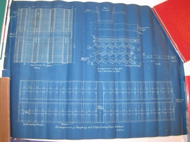
Drawing, Electric Supply Co. of Vic (ESCo), "Arrangements of Troughing at ESCo Cooling Tower Ballarat", 4/12/1914 12:00:00 AM
Yields information about the cooling tower troughing arrangements within the cooling tower itself at the power station.Rolled blue print of the "Arrangements of Troughing at ESCo Cooling Tower Ballarat" showing how the various systems to pipe and pass air through the water falling onto timber hurdles was made. Gives dimensions and details of the timber and arrangements made. Date 4.12.1914.ballarat, power station, ballarat a power station, esco -
 Ballarat Tramway Museum
Photograph - Black & White Photograph/s, Oct. 1939
Black and White print contained within the Wal Jack Bendigo and Geelong Album, see Reg Item 5003 for more details. Photo of Bendigo sprinkler or scrubber tram just inside the depot gates, October 1939. Shows the curtains around one side of the tram, hose lines and lights underneath the ends of the tram. Printed on Velox paper. i1 - scan of print in the album i2 - rear of image i3 - scan of negative at 3200dpi added 6/6/2020.On the rear in blue ink "Bendigo Brush Water Tram built by Brush Engineering Co. England"trams, tramways, bendigo, sprinkler tram, scrubber tram, depot, sprinkler, scrubber -
 Ballarat Tramway Museum
Photograph - Black & White Photograph/s, Wal Jack, 7/03/1954 12:00:00 AM
Black and White print contained within the Wal Jack Bendigo and Geelong Album, see Reg Item 5003 for more details. Photo of the first or old Bendigo Water tram or scrubber inside the depot, 7-3-1954, Photo by Wal Jack. Wal's album notes say that the vehicle is "now out of use". See Reg Item 7880 for another photograph from the other side. See image i2 for rear of photograph. See image i3 for hi res scan of negative On the rear in blue ink "SEC old "Brush" scrubber inside depot 7-3-54" with Wal Jack copyright stamp in the top right hand corner and the number "T73PC" written in.trams, tramways, bendigo, depot, scrubber tram, sprinkler tram, scrubber, sprinkler -
 Ballarat Tramway Museum
Photograph - Black & White Photograph/s, Wal Jack, 1940
Black and White print contained within the Wal Jack Bendigo and Geelong Album, see Reg Item 5003 for more details. Photograph of the Geelong Scrubber, sprinkler or water tram in Corio Terrace 1940. Photo has a large "blotch" in the negative over the tramcar itself. No details as to photographer. Printed on Kodak Velox Paper, but negative located in the Wal Jack negative envelopes. i1 - scan of print in the album i2 - rear of image i3 - scan of negative at 3200dpi added 18/6/2020.On rear is "35-" in penciltrams, tramways, geelong, corio terrace, scrubber tram, sprinkler tram, scrubber, water tram, sprinkler -
 Ballarat Tramway Museum
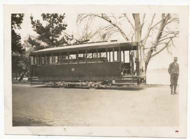
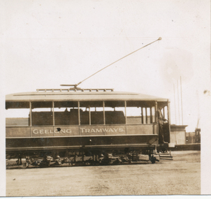
Photograph - Black & White Photograph/s, c1930
Black and White print contained within the Wal Jack Bendigo and Geelong Album, see Reg Item 5003 for more details. Photograph of the Geelong Scrubber, sprinkler or water tram at the wharf. Tram lettered "Geelong Tramways", possibly prior to SEC takeover, c1930. Printed on Kodak Paper. Photographer unknown. On rear in ink "Geelong Tramways Water car"trams, tramways, geelong, wharf, scrubber tram, sprinkler tram, scrubber, water tram, sprinkler -
 Ballarat Tramway Museum
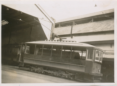
Photograph - Black & White Photograph/s, Leon Marshal Wood, 29/03/1948 12:00:00 AM
Black and White print contained within the Wal Jack Bendigo and Geelong Album, see Reg Item 5003 for more details. Photograph of the Geelong Scrubber, sprinkler or water tram at the depot, Photo by Leon Marshal Wood, 29-3-1948, photo printed on Kodak Velox Paper.On rear in ink "Geelong 29-4-48" and the Leon Marshal Wood copyright stamp.trams, tramways, geelong, depot, scrubber tram, sprinkler tram, scrubber, water tram, sprinkler -
 Ballarat Tramway Museum
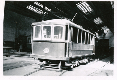
Photograph - Black & White Photograph/s, Wal Jack, 24/06/1949 12:00:00 AM
Black and White print contained within the Wal Jack Bendigo and Geelong Album, see Reg Item 5003 for more details. Photograph of the Geelong Scrubber, sprinkler or water tram in the depot, Photo by Wal Jack 24-6-1949, i1 - scan of print in the album i2 - rear of image i3 - scan of negative at 3200dpi added 27/6/2020.On rear in ink SEC Geelong / Scrubber inside Geelong Car Sheds / 24-6-49". Has the Wal Jack copyright stamp in the top right hand corner with the number T299 written in.trams, tramways, geelong, depot, scrubber tram, sprinkler tram, track cleaner, scrubber, water tram, sprinkler -
 Bendigo Historical Society Inc.
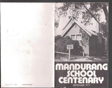
Book - JOHN JONES COLLECTION: MANDURANG SCHOOL CENTENARY SEPTEMBER 1977, September 1977
Small booklet titled Mandurang School Centenary September 1977. It has a black and white picture of the school on the front cover. Mentioned in the book is the History of Mandurang State School and District, Industries, Wine, Milk, Gold, Tannery, The Look-Out, Timber, Hotels, Water Race, Floods, Post Office, Sports, Churches, Fire Brigade, List of Head Teachers 1861 - 1975, The School opens 1877 and Mothers' Club. Photos include Mr & Mrs J T Deravin Pioneer settlers of Mandurang, Deravin's Barn & Wine Cellars, Bernado Togno's Vineyard, Hargreave's Milk Cart, J Pearce & Sons Milk Delivery Bike, The Tannery, Wooden Poppet Head Tower, Kerr's Hotel, The Wine Hall (Previously Junction Hotel), Harry & Len Kofoed's Wood Trucks, Mandurang Recreation Reserve 1977, Mandurang Cricket Club (1889 or thereabouts), Methodist Church, School Pupils 1894, Early School Group, School Pupils 1960 and 1962, Working Bee before shifting School Building to it's Present Site, School Pupils 1922 and School Pupils 1977.Edwin J. Watts. Express Print, Bendigoeducation, primary, mandurang primary school no 1952, john jones collection - mandurang school centenary september 1977, edwin j watts, kevin o'brien, g pearce, j sloan, v togno, r pearce, j french, i adams, b adams, g grose, i kofoed, j pearce, f pentland, g shaw, n todd, i grose, h koefoed, m macdonald, k pearce, t french -
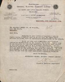 Ballarat Tramway Museum
Letter - re controller parts - ESCo, Australian General Electric, 9/1924
Letter from the Australian General Electric Co. Ltd, agents for General Electric and British Thomson Houston (BTH) tramway equipment to ESCo Ballarat regarding spare parts for B-49 controllers manufactured by BTH. Enclosed a copy of the B-23 controller which had similar parts. Dated 13/9/1924.Demonstrates the issues of spare parts for old equipment.Letter typed on quarto sheet - has a water mark and the GE ad BTH logos.tramways, tramcars, controllers, general electric, bth, spare parts -
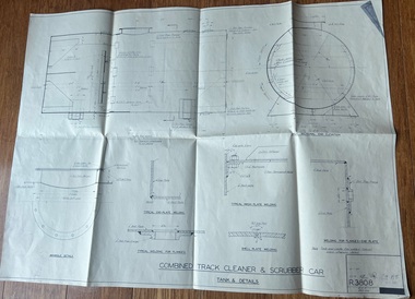 Ballarat Tramway Museum
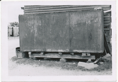
Drawing - R3808, Melbourne and Metropolitan Tramways Board (MMTB), Combined Track Cleaner & Scrubber Car - Tank & Details, 1934
Drawing of the water tank for scrubber car 8 operated by the Ballarat Tramway Museum, showing the materials, welding and dimensions.Yields information about the water tank for scrubber tank fitted to scrubber tram 8Drawing - dyeline print folded into 8tramcars, work cars, scrubber tram, water tank, tram 8 -
 Bayside Gallery - Bayside City Council Art & Heritage Collection
Sculpture, Lenton Parr, Windhover, 2001
Inspired by a well-loved poem of Gerard Manley Hopkins, the abstract sculpture is reflective of the elements of Bayside's coastal environment: wind, water and waves.welded steel Public Art Commission located on Sandringham Foreshore Reserve, Beach Rd, near Sandringham Life Saving Club, Sandringham, Victoria.sculpture, windhover, clouds, wind, waves, lenton parr, public art, sandringham, foreshore, bayside art coastal trail, beach road -
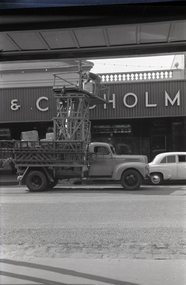 Ballarat Tramway Museum
Negative, Wal Jack, mid 1950's
Yields information about the Ballarat Tower truck and its use to put up festoon lighting in Bridge St.Negative and Digital images of the Wal Jack Ballarat Negative file of the SEC Ballarat tower truck in the Bridge Mall, putting up festoon lighting for the an event or season. Truck outside the McDougall & Chisholm shop. Truck has the SEC logo on the door and a water bag.trams, tramways, bridge st, events, tower truck -
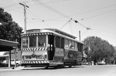 Ballarat Tramway Museum
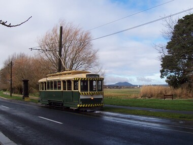
Photograph - Ballarat Tram 12 at Mt Pleasant terminus, Robert Wilson, 11-11-1967
Image of Ballarat tram 12 at the Mt Pleasant terminus before returning to the Gardens via Drummond St North. The tram has a dash panel advert for the Twin Lakes, a long closed water ski resort near Ballan.Yields information about the Mt Pleasant terminus in late 1967.Digital image of Ballarat Tram 12 at Mt Pleasant terminus 11-11-1967.trams, tramways, mt pleasant, ballarat tramways, tram 12, twin lakes