Showing 600 items matching "weir"
-
 Rutherglen Historical Society
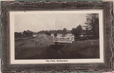
Image, 1900s
Black and white photo shows the weir and Lake King in the Rutherglen Park. The colour photograph is of an ocean liner, the Osterley.Two postcards pasted onto either side of a piece of green cardboard, probably cut from an album. One photo is a black and white photograph. One is in colour.At bottom of black and white photograph: "The Park, Rutherglen" On the top left corner of the colour photograph: "R.M.S. Osterley | 12 129 tons, 14 000 H. Power" rutherglen park, lake king, rms osterley -
 Yarrawonga and Mulwala Pioneer Museum
Ashtrays
Two metal ashtrays . One round with three cigarette indentations and a small blue meal picture of Weir Bridge on outside rim. One square metal ashtray with four cigarette indentations - small blue picture on metal medallion in the centre.Yarrawonga Keywords - Souvenirs, Ashtray -
 Kew Historical Society Inc
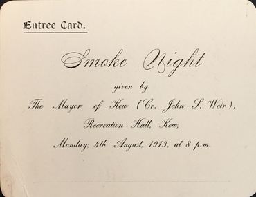
Document (item) - Entree Card, Town of Kew, Smoke Night, 1913
The Municipality of Kew (1860-1863), the Borough of Kew (1863-1910), the Town of Kew (1910-1921) and the City of Kew (1921-1994) were local government instrumentalities in the State of Victoria. In 1994, the City of Kew was amalgamated, together with the former Cities of Camberwell and Hawthorn, into the new City of Boroondara (1994- ). Like other local government entities of the period, Kew was administered by town clerks. The two notable town clerks in Kew's history were H. H. (Henry Hirst) Harrison (1868-1955) and W. D. (William Dickie) Birrell (1899-1974). Harrison was appointed to the position in 1901 and retired in 1938 after 37 years. Birrell, appointed Acting Town Clerk in 1921, became Town Clerk in 1938, following Harrison's retirement. He continued in this role until his retirement in 1966.This card is part of an historically significant civic collection, containing hundreds of separate invitations, documents, greeting cards, programmes and tickets issued and/or collected by successive town clerks. Items in the collection illuminate the political, social and cultural history of the district. As a continuous record, ranging across most decades of the Twentieth Century, they reveal changing tastes in design, values and relationships in the history of local government in Victoria.ENTREE CARD / SMOKE NIGHT GIVEN BY THE MAYOR OF KEW (CR JOHN S WEIR) / RECREATION HALL, KEW / MONDAY; 4TH AUGUST, 1913, AT 8 P.M.civic ephemera -- town of kew, entree cards, smoke nights -
 Kew Historical Society Inc
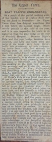
Newspaper - Article, The Upper Yarra: boat traffic endangered, 1918-20
An item of ephemera relating to tourism and recreation on the Yarra River in Melbourne in the first half of the twentieth century.An item from a large collection assembled by the Christian and Washfold families of Kew, including photographs, postcards, and ephemera. Many of the items in the Christian-Washfold Collection relate to the Yarra River and its use as as a recreational resource. Numerous items in the collection are historically important in that they are rare and often unique records of vanished locations or past recreational activities.Article describing the effects of the partial collapse of the weir at Dight’s Falls and its impact on water levels between Kew, Fairfield, and Heidelberg. The article is undated however as it describes Cr Harry Tompkins as Mayor of Kew it must date to the years 1918-20.christian-washfold collection, river yarra -- recreation, dight's falls -
Tatura Irrigation & Wartime Camps Museum
Folder, Articles on History of Waranga Basin, 2000
Extract from Waranga News on early history of Waranga Basin. Maps. Other stories of families at Basin, Goulburn River and Goulburn WeirBlue cover. Black spiral spine. White label. Title in blue penhistory of waranga basin, knee l, tatura, irrigation, books, history, local, rural -
Tatura Irrigation & Wartime Camps Museum
Folder, Irrigation Structures, 1995
Photos of Waranga Basin outlet. Construction of new Torrumbarry Weir 1997 and newspaper report of Hume Dam and other Rural Water information.Grey plastic cover, black spine. Title label insideirrigation, documents, reports, books, history, local, rural, industry -
 Rutherglen Historical Society
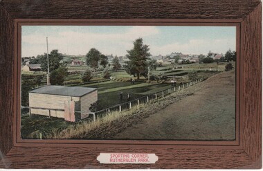
Image, Sporting Corner, Rutherglen Park, 1910 to 1912
Rutherglen Park is located in Murray Street. The grounds shown are now the bowling club. Photo taken from the top of the weir of Lake King.Coloured photograph on a post card, with brown border, showing a view of a one end of the Rutherglen Parksports grounds, rutherglen bowling club, rutherglen park, murray street -
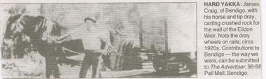 Bendigo Historical Society Inc.
Newspaper - JENNY FOLEY COLLECTION: HARD YAKKA
Bendigo Advertiser "The way we were" from Thursday, February 17, 2005. Hard yakka: James Craig of Bendigo with his horse and tip dray, carting crushed rock for the wall of the Eildon weir. Note the dray wheels on rails, circa 1920s.newspaper, bendigo advertiser, the way we were -
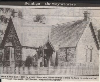 Bendigo Historical Society Inc.
Newspaper - JENNY FOLEY COLLECTION: HOPE PARK
Bendigo Advertiser "The way we were" from 1999. Hope park: built in 1867 by architect David Weir, he literally tried to make his home his castle and had two acres of vines and by 1872 he was calling himself a vigneron.newspaper, bendigo advertiser, the way we were -
Tatura Irrigation & Wartime Camps Museum
Photograph, May, 1888
Taken by photographer for State Rivers and Water Supply Commission.Medium sized black and white photograph. Weir being constructed of granite blocks quarried from nearby Mt. Black. Four men standing on the granite steps - gantry right mid-picture. Note: Empty cart resting mid-top of picture.goulburn weir, victorian state rivers and supply commission -
 Clunes Museum
Photograph
BLACK AND WHITE PHOTOGRAPH WILLIAM UNWIN COWLAND BUILT BALLARAT AND CLUNES TOWN HALLS AND VARIOUS OTHER BUILDINGS - ALSO GLENORCHY WEIR. HE BECAME PRESIDENT OF STAWELL 11 CHILDREN - 3 WIVES - BORN 1825 - DIED 1900 - BURIED GLENORCHY.AS ABOVElocal history, photography, photograph, town halls, builder -
Tatura Irrigation & Wartime Camps Museum
Leaflet, Local Places of Historical Interest, 1972
Recorded by Nagambie Historical Society. History of Kirwan's Bridge, Angustown, Aboriginal Camp ovens, Day's Mill, Oold pumping site, Goulburn WeirGold cover, black writing. Compiled September, 1972books, history, local -
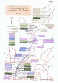 Greensborough Historical Society
Maps, Yan Yean Water Supply System Conservation Management Plan: Construction dates Map 1, 2007_
Plan of Yan Yean Water Supply System, showing natural and constructed features from 1850s to 1930s from Silver Creek Weirs to Eastern Freeway.Printed in colour one side. 3 copieswater supply, yan yean reservoir, plenty river -
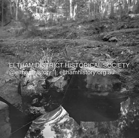 Eltham District Historical Society Inc
Negative - Photograph, J.A. McDonald, Hurstbridge Water Scheme, 11 May 1961
Weir on Running Creek at Map Ref YAN YEAN 249699 11 May 1961 Reading 8” V http://wikimapia.org/10473910/Running-Creek-ReservoirRecord of various Shire of Eltham infrastructure works undertaken during the period of 1952-1962 involving bridge and road reconstruction projects, sometimes with Eltham Shire Council Project Reference numbers quoted. It was during this period that a number of significant improvements were made to roads and new bridges constructed within the shire that remain in place as of present day (2022). In many situations, the photos provide a tangible visible record of infrastructure that existed throughout the early days of the Shire. The album was put together by or under the direction of the Shire Engineer, J.A. McDonald.infrastructure, road construction, shire of eltham, 1961-05-11, hurstbridge water scheme -
Tatura Irrigation & Wartime Camps Museum
Leaflet, Local Places of Historical Interest, 1972
Recorded by Nagambie & District Historical Society. History of Kirwan's Bridge, Angustown, Aboriginal Camp Ovens, Day's Mill, Old pumping station site, Goulburn Weir.Gold cover, black writing. Compiled September 1972books, history, local -
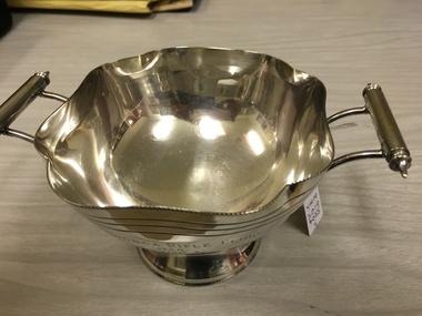 Yarrawonga and Mulwala Pioneer Museum
Memorabilia - Yarrawonga Rifle club trophy, 1950
Ollie Meritan was the manager for Whiteheads who bought Sloanes Mulwala station on the Murray River. I D Forbes was the Weir Manager at the time and a member of the rifle clubSilver sugar basin. Round bowl with petal shaped edges on a small stand. It has two handles attachedYarrawonga rifle club 1950. Donated by O. Meritan won by I D Forbes -
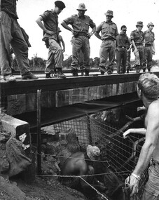 National Vietnam Veterans Museum (NVVM)
Photograph, Gibbons, Denis, Bridge Inspection
Denis Gibbons (1937 – 2011) Trained with the Australian Army, before travelling to Vietnam in January 1966, Denis stayed with the 1st Australian Task Force in Nui Dat working as a photographer. For almost five years Gibbons toured with nine Australian infantry battalions, posting compelling war images from within many combat zones before being flown out in late November 1970 after sustaining injuries. The images held within the National Vietnam Veterans Museum make up the Gibbons Collection. A black and white photograph of the 1st Australian Task Force Commander (Aug 1969 - Jun 1970) Brigadier Stewart Weir MC, inspects a bridge built by 17 Construction Squadron over a creek northwest of the province capital Baria. The Engineers are fitting screens to protect the foundations.photograph, brig stewart weir, 1st atf base, baria, gibbons collection catalogue, 17th construction squadron, engineers, military cross, 1st australian task force, denis gibbons -
Tatura Irrigation & Wartime Camps Museum
Booklet - Book, History of the Waranga Basin, 1977
As part of rich history of Rushworth after gold was discovered. Gunn's swamp became Waranga Basin when a 24 miles channel was constructed from the Goulburn Weir to the inlet.Blue cover, black writing, yachting scene on front cover. Waranga basin inlet and outlet pictures on the backJoyce Hammond 19/8/77irrigation, books, history, local -
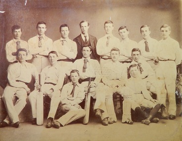 Ballarat Clarendon College
Photograph, Ballarat College Premiers 1893-94
Sepia toned formal pose; mount has title at top and names inscribed below photograph very faintly; students are dressed in cricket whites; teacher in centre of top row.Inscribed on mount below photograph: A Nevett, ....watt, S Swan, Mr Alston, W Paterson, J Weir, ...Bell, E Bryant / N Booth, A Tuthill, E A Uthwatt, ...., ...., / A McRae, ....,cricket, 1893, ballarat college, premiers -
Clunes Museum
Document - REPORT
PHOTOCOPY PORTION OF REPORT OF DAMAGED WEIR AT GLENORCHY JULY 1882 WHEN WILLIAM COWLAND, WORK SUPERVISOR, AND HIS GANG WORKED DAY AND NIGHT TO REINFORCE THE DAMAGED BANKS. THE EMBANKMENT HAD BEEN BUILT SEVERAL TIMES BEFORE IT WAS FINALLY SUCCESSFUL AND WITHSTOOD THE BIG FLOOD 1883local history, pamphlet, report, cowland, history -
 Eltham District Historical Society Inc
Document - Series Listing, Fraser Faithfull et al, Series 55: Art in Public Places Awards 1992 & 1994, photographic negatives, 2000
Series consists of: * 59 colour and 21 B&W negatives taken on the night of the award presentation and at Weir St Park in Montmorency. * 24 colour negatives from 1994 ceremony.shire of eltham archives, series listing -
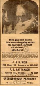 Greensborough Historical Society
Advertisement - Digital image, Diamond Valley News, Greensborough Pharmacy, 1967, 28/11/1967
Advertisement in the local paper for Greensborough Pharmacy, Main Street Greensborough 1967. Also associated with J & D Weir of Plenty Road Bundoora and A.S. Cattanach of Watsonia Road Watsonia.Part of a collection of historic advertisements from local newspapers, showing local businesses from the mid 20th century.Digital copy of newspaper advertisement.watsonia road, pharmacies, greensborough pharmacy, weir pharmacy, cattanach pharmacy -
Tatura Irrigation & Wartime Camps Museum
Book, Water Ledger, 1928
Ledger used at State Rivers & Water Supply Commission - Rodney District, showing water discharges from Waranga and Goulburn Reservoir and Weir and channels. Also rainfall. 1928 to 1950Large book.Green cardboard cover. suede leather spine and cornersirrigation, rural, industries, irrigaiton -
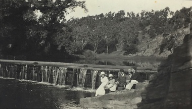 Kew Historical Society Inc
Photograph, Richardson Family at Dight's Falls, 1920
Dight’s Falls in Studley Park is an artificial weir built on a natural rock bar across the Yarra. The weir was built in the 1840s to provide water to the ‘Ceres’ flour-mill, one of the first in Victoria. The falls were later to become known as Dight’s Falls after the owners of the mill. Later, a pumping station was built on the Kew side of the river, which pumped water uphill to a reservoir in Walmer Street that provided water to the Melbourne Botanical Gardens and to Albert Park Lake. The area around Dight’s Falls was and is frequently used for recreational activities.This photograph forms part of the collection assembled by the historian Dorothy Rogers, that was donated to the Kew Historical Society by her son John Rogers in 2015. The manuscripts, photographs, maps, and documents were sourced by her from both family and local collections or produced as references for her print publications. Many were directly used by Rogers in writing ‘Lovely Old Homes of Kew’ (1961) and 'A History of Kew' (1973), or the numerous articles on local history that she produced for suburban newspapers. Most of the photographs in the collection include detailed annotations in her hand. The Rogers Collection provides a comprehensive insight into the working habits of a historian in the 1960s and 1970s. Together it forms the largest privately-donated collection within the archives of the Kew Historical Society.Black and white photograph of the Richardson family seated on the Kew side of Dight's Falls in 1920. One of the girls in the photograph was to become the Melbourne historian Dorothy (Richardson) Rogers.Annotation on reverse: "Mrs D. Rogers, 29 Park Crst Kew. Dights Falls 1920"dight's falls - kew (vic) - fairfield (vic), sport and recreation - kew (vic), dorothy rogers -
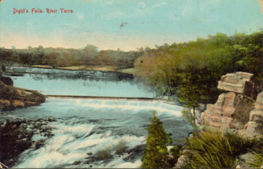 Kew Historical Society Inc
Postcard - Dight's Falls, River Yarra, c.1911
Dight’s Falls in Studley Park is an artificial weir built on a natural rock bar across the Yarra. The weir was built in the 1840s to provide water to the ‘Ceres’ flour-mill, one of the first in Victoria. The falls were later to become known as Dight’s Falls after the owners of the mill. Later, a pumping station was built on the Kew side of the river, which pumped water uphill to a reservoir in Walmer Street that provided water to the Melbourne Botanical Gardens and to Albert Park Lake. The area around Dight’s Falls was and is frequently used for recreational activities.Dated postcard allowing one to analyse the form of the Falls in 1911Colour postcard, of Dight's Falls on the River Yarra between Kew and Fairfield. The photograph is taken looking upstream towards the Falls from the Kew side, from the embankment in the vicinity of the Pumping Station. Obverse: "Dight's falls, Kew" Reverse: "Printed in Great Britain Writing in ink on Reverse: "31/3/1911 / To dear Nell with best wishes for a happy birthday from your old friend Eve / [Addressed to] "Mrs N Dunn, Prahran" Franked Victorian 1d stamp on Reverse top rightdight's falls, dight's falls - kew (vic) - fairfield (vic) -
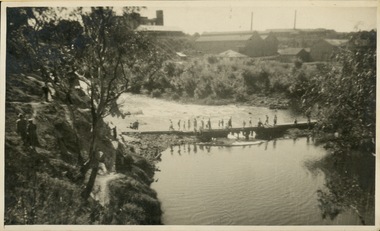 Kew Historical Society Inc
Photograph - Crossing Dights' Falls on the Yarra by foot
Dight’s Falls in Studley Park is an artificial weir built on a natural rock bar across the Yarra. The weir was built in the 1840s to provide water to the ‘Ceres’ flour-mill, one of the first in Victoria. The falls were later to become known as Dight’s Falls after the owners of the mill. Later, a pumping station was built on the Kew side of the river, which pumped water uphill to a reservoir in Walmer Street that provided water to the Melbourne Botanical Gardens and to Albert Park Lake. The area around Dight’s Falls was and is frequently used for recreational activities.Rare original print photograph of people walking across Dight's Falls when the river flow was low. View west towards Abbotsford. Photograph taken from Kew side of river above the Falls.Reverse: "M Holmes"dight's falls, river yarra -- kew - abbotsford -
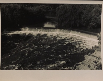 Kew Historical Society Inc
Photograph - Dight's Falls, 1920s
Dight’s Falls in Studley Park is an artificial weir built on a natural rock bar across the Yarra. The weir was built in the 1840s to provide water to the ‘Ceres’ flour-mill, one of the first in Victoria. The falls were later to become known as Dight’s Falls after the owners of the mill. Later, a pumping station was built on the Kew side of the river, which pumped water uphill to a reservoir in Walmer Street that provided water to the Melbourne Botanical Gardens and to Albert Park Lake. The area around Dight’s Falls was and is frequently used for recreational activities.One of a series of photographs, probably taken by Henry Christian of the Yarra River in Kew. An item from an outstanding and diverse photographic collection, assembled by members of the Christian and Washfold families of Kew.River Yarra at Dight’s Falls, Kew/Fairfield photographed from Kew bank.dight's falls, river yarra, christian-washfold collection -
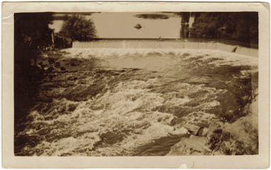 Kew Historical Society Inc
Photograph - The Race at Dight's Falls, 1925
Dight’s Falls in Studley Park is an artificial weir built on a natural rock bar across the Yarra. The weir was built in the 1840s to provide water to the ‘Ceres’ flour-mill, one of the first in Victoria. The falls were later to become known as Dight’s Falls after the owners of the mill. Later, a pumping station was built on the Kew side of the river, which pumped water uphill to a reservoir in Walmer Street that provided water to the Melbourne Botanical Gardens and to Albert Park Lake. The area around Dight’s Falls was and is frequently used for recreational activities.Original, black and white positive of water flowing over the 'Race' at Dight's Falls in MelbourneInscribed verso: "The Race at Dight's Falls / River Yarra Melbourne / 1.3.25" "Kodak Print"dight's falls, river yarra, yarra -- kew (vic.)